No matching terms. Try an alternate spelling or choose all geology subjects.
Average seismic velocity
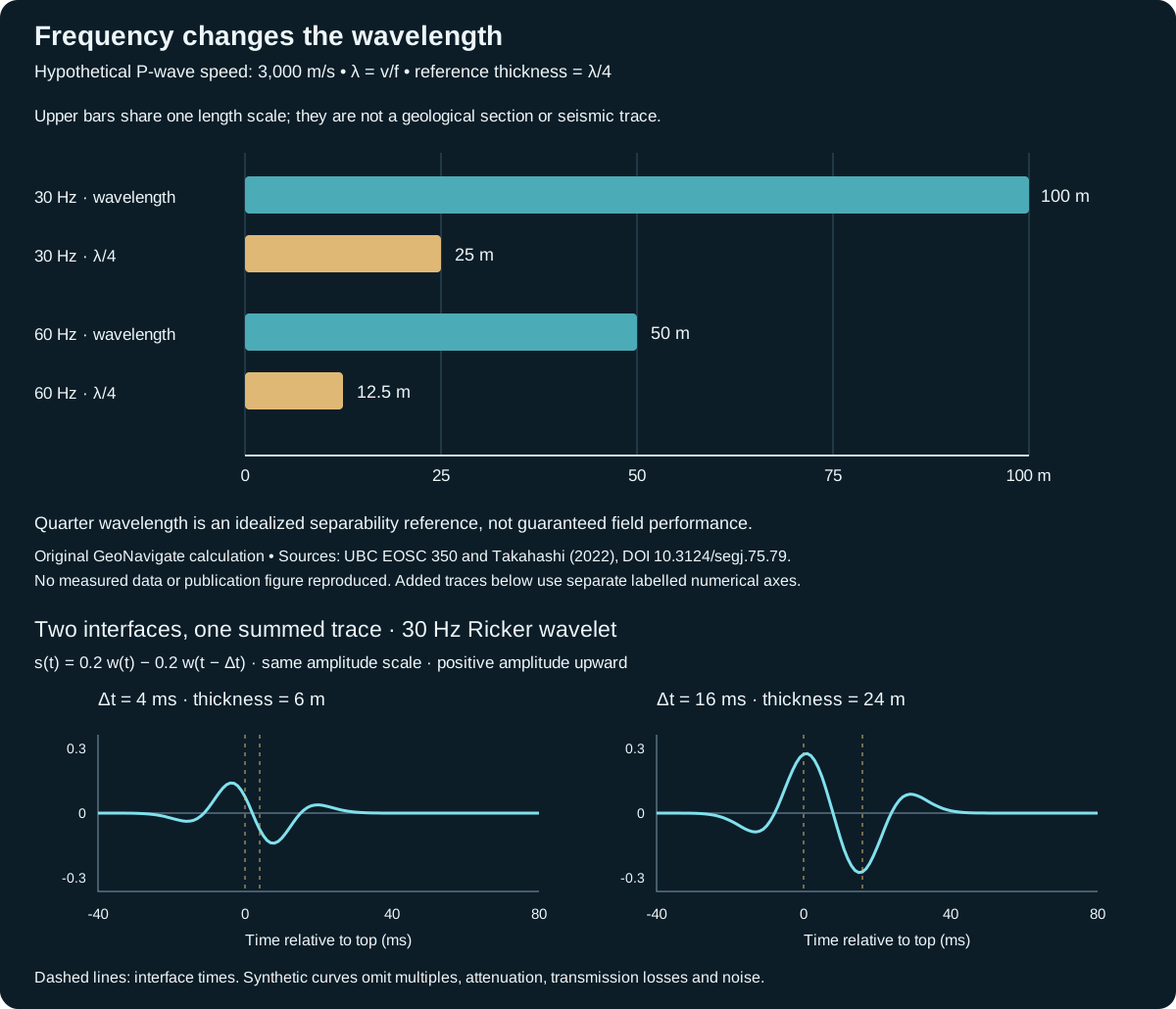
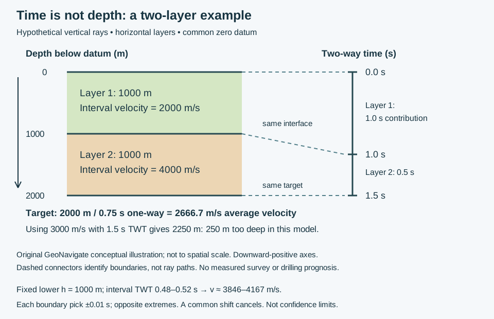
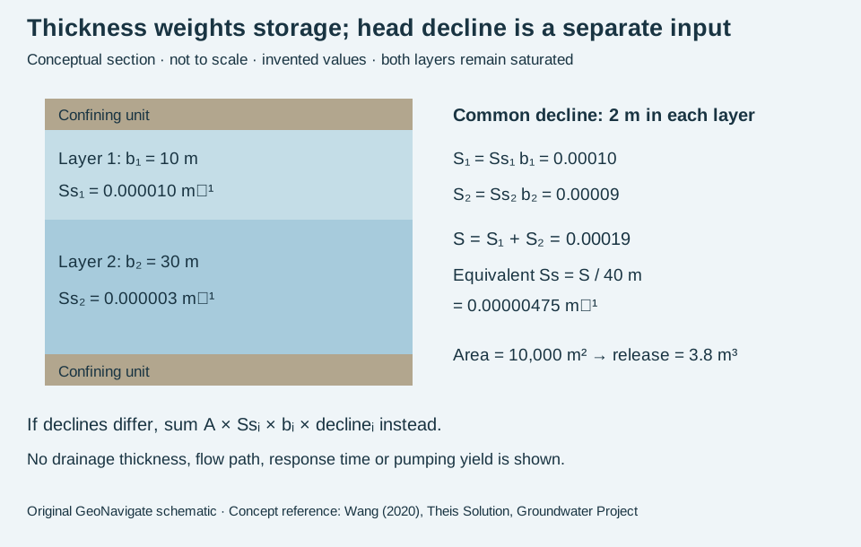
Effective vertical seismic speed from a specified datum to a target, calculated as vertical distance divided by one-way travel time under the stated ray-path assumptions. For a vertical two-way reflection time t, the equivalent average is 2z/t; it is not generally the arithmetic mean of the interval velocities.
Worked example: two layers, travel time and depth
Also called: Average velocity (seismic)
Reference & related terms
SLB Energy Glossary — average velocityReference reviewed 2026-10-28
Related: Interval velocity · Two-way travel time · Depth conversion · Checkshot survey · Root-mean-square velocity
View schematic: Two layers: travel time and depth are different coordinates
View in the Oilfield Glossary →
Depth conversion
Transformation of seismic interpretations from travel-time coordinates into estimated depth using a velocity model and consistent reference datums. The result depends on the velocity information and imaging assumptions; changing the axis label alone does not establish a depth model.
Worked example: two layers, travel time and depth
Also called: Seismic time-to-depth conversion
Reference & related terms
US EPA — Seismic ReflectionReference reviewed 2026-10-28
Related: Average seismic velocity · Two-way travel time · Interval velocity · Seismic datum · Depth migration · Checkshot survey
View schematic: Two layers: travel time and depth are different coordinates
View in the Oilfield Glossary →
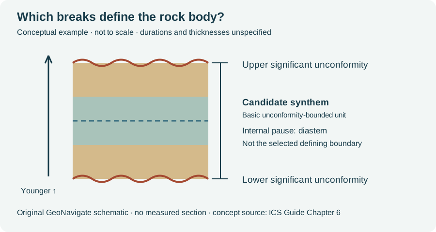
Geological time & dating# Global Boundary Stratotype Section and Point GSSP
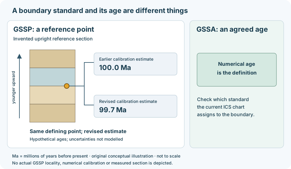
An internationally ratified reference point in a specified stratigraphic section that fixes a boundary on the geological time scale. Correlation markers help identify its time-equivalent level in other successions.
Interpretation note A local fossil occurrence or log pick is evidence for correlation, not a new GSSP. Check the ratified reference and supporting markers.
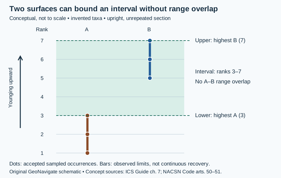
Worked example: a fixed boundary and a revised age
Also called: Golden spike
Reference & related terms
ICS — Global Boundary Stratotype Sections and PointsReference reviewed 2026-10-25
Related: Global Standard Stratigraphic Age · Chronostratigraphic unit · Geochronologic unit
View schematic: Boundary definition and numerical calibration
View in the Oilfield Glossary →
Geological time & dating# Global Standard Stratigraphic Age GSSA
An internationally agreed numerical age used to define a boundary on the geological time scale, particularly in parts of the Precambrian. Its defining reference is a number rather than a designated point in a stratigraphic section.
Interpretation note Distinguish a defining GSSA from the estimated numerical age of a GSSP. Consult the current ICS chart for the standard assigned to a particular boundary.
Worked example: a fixed boundary and a revised age
Reference & related terms
ICS Guide — Chronostratigraphic Units, Precambrian subdivisionReference reviewed 2026-10-25
Additional clarification reference
Related: Global Boundary Stratotype Section and Point · Geochronologic unit · Radiometric dating
View schematic: Boundary definition and numerical calibration
View in the Oilfield Glossary →
Sedimentology & sedimentary rocks# Graded bedding
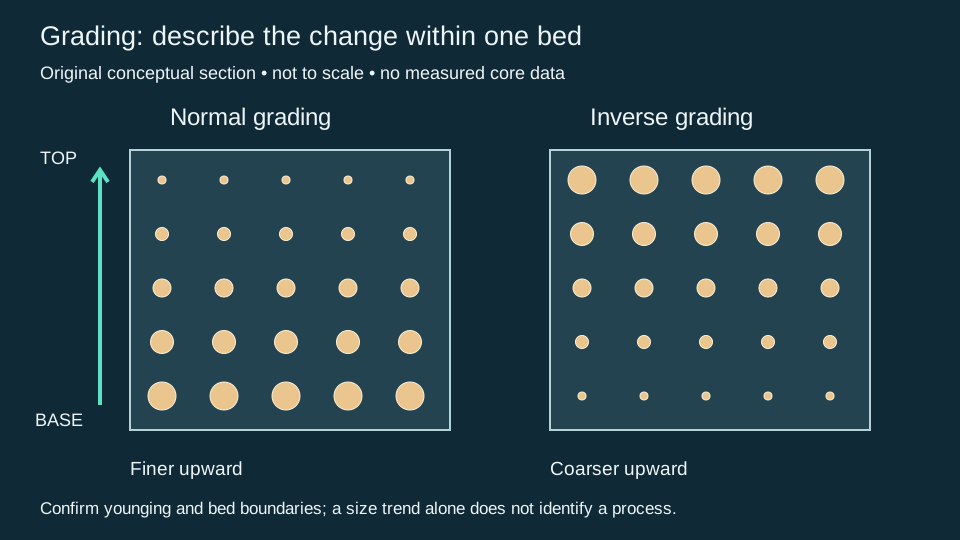
A systematic change in grain size through the thickness of a sedimentary bed. Describe the direction and scale of the change before interpreting the depositional process.
Worked example: grading within one bed
Also called: Sedimentary grading
Reference & related terms
IODP Expedition 400 — Methods: sedimentary structuresReference reviewed 2026-10-25
Related: Normal grading · Inverse grading · Grain size · Turbidite
View schematic: Normal and inverse sedimentary grading
View in the Oilfield Glossary →
Sedimentology & sedimentary rocks# Normal grading
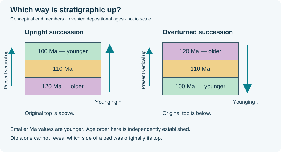
An upward decrease in grain size within a bed, with coarser particles below finer particles. Upward refers to stratigraphic younging, which need not coincide with present vertical.
Interpretation note Determine stratigraphic way-up separately from present vertical: a normal graded bed fines toward its original top even after overturning. Confirm the depositional interpretation with other indicators before assigning younging.
Worked example: which way is stratigraphic up?
Also called: Normally graded bedding
Reference & related terms
IODP Expedition 400 — Methods: sedimentary structuresReference reviewed 2026-10-25
Related: Graded bedding · Inverse grading · Grain size · Turbidite · Younging direction · Overturned bedding
View schematic: Normal and inverse sedimentary grading
View in the Oilfield Glossary →
Sedimentology & sedimentary rocks# Inverse grading
An upward increase in grain size within a bed. The observation describes a texture; it does not by itself identify a unique transport mechanism or depositional environment.
Worked example: grading within one bed
Also called: Reverse grading, Inversely graded bedding
Reference & related terms
IODP Expedition 400 — Methods: sedimentary structuresReference reviewed 2026-10-25
Related: Graded bedding · Normal grading · Grain size · Turbidite
View schematic: Normal and inverse sedimentary grading
View in the Oilfield Glossary →
Igneous rocks & volcanology# Aa lava
Basaltic lava characterized by a rough, broken, clinker-covered surface.
Also called: A'a, ‘A‘ā
Reference & related terms
USGS — Volcano Hazards Program GlossaryReference reviewed 2026-10-25
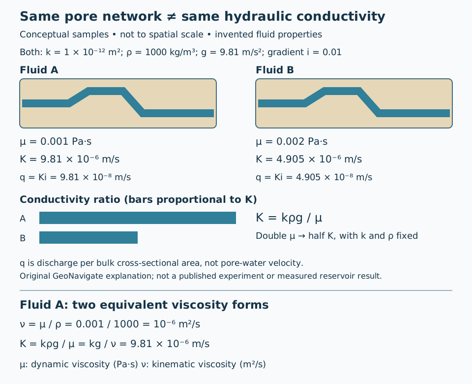
Hydrogeology & pore systems# Absolute permeability
Rock permeability measured with a single fluid phase occupying its connected pores.
Interpretation note In the single-phase Darcy-flow context, this corresponds to intrinsic permeability of the pore network. Hydraulic conductivity additionally incorporates fluid properties: K = kρg/μ. This comparison assumes unchanged pore geometry and a fully saturated medium.
Worked example: permeability versus hydraulic conductivity
Also called: Intrinsic permeability
Reference & related terms
SLB Energy Glossary — absolute permeabilityReference reviewed 2026-10-24
Related: Permeability · Hydraulic conductivity
View schematic: Same pore network, different hydraulic conductivity
View in the Oilfield Glossary →
Stratigraphy & correlation# Accommodation space
Space available for sediment accumulation, influenced by subsidence and changes in sea level.
Also called: Accommodation
Reference & related terms
SLB Energy Glossary — accommodationReference reviewed 2026-10-24
View in the Oilfield Glossary →
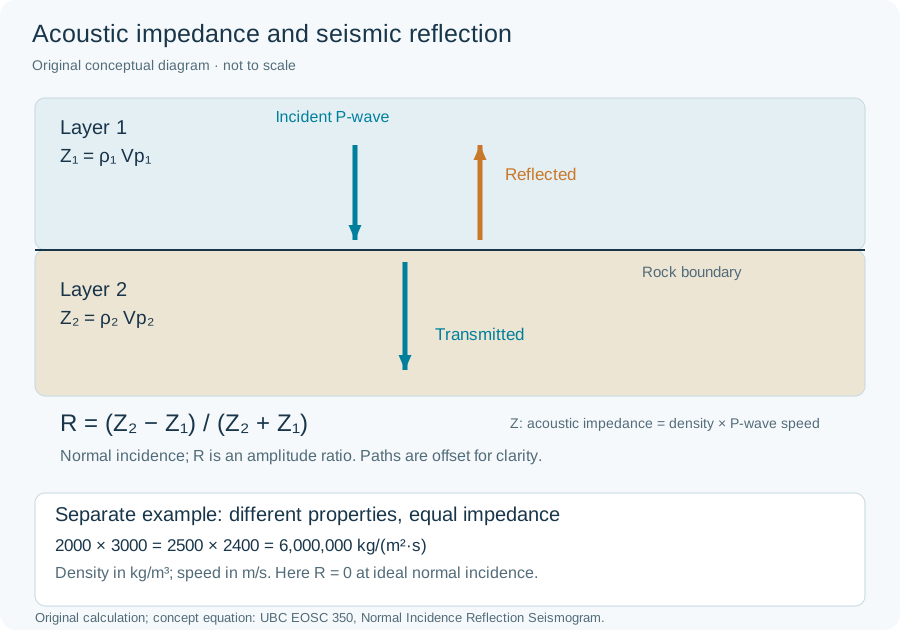
Acoustic impedance
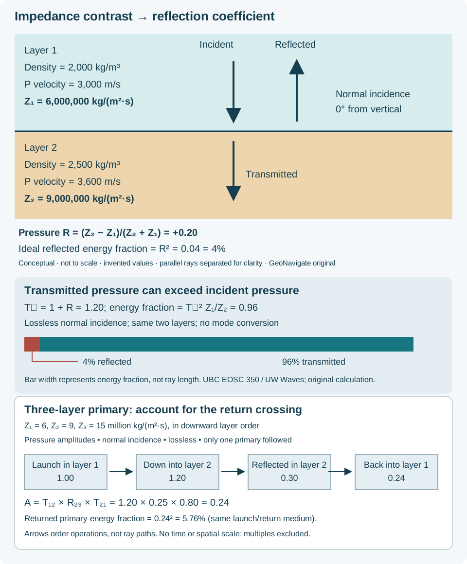
Product of rock bulk density and compressional-wave velocity; contrasts between layers influence seismic reflections.
Interpretation note For a P wave, Z = bulk density × P-wave velocity. Use compatible units: kg/m³ × m/s gives kg/(m²·s). Equal impedance can occur in different lithologies; impedance is not a unique rock identifier. For example, 2000 kg/m³ × 3000 m/s and 2500 kg/m³ × 2400 m/s both give 6 million kg/(m²·s), despite different densities and speeds.
Worked example: different properties, equal impedance
Also called: Seismic impedance
Reference & related terms
SLB Energy Glossary — acoustic impedanceReference reviewed 2026-10-30
Related: Compressional wave · Shear wave · Seismic trace · Normal incidence · Reflectivity series
View schematic: Acoustic impedance and seismic reflection
View in the Oilfield Glossary →
Igneous rocks & volcanology# Agglutinate
A pyroclastic deposit whose hot, partly molten fragments welded together after landing.
Reference & related terms
USGS — Volcano Hazards Program GlossaryReference reviewed 2026-10-25
Stratigraphy & correlation# Aggradation
Upward accumulation of sediment with relatively little overall advance or retreat of the depositional system.
Reference & related terms
SLB Energy Glossary — aggradationReference reviewed 2026-10-24
View in the Oilfield Glossary →
Amphibole
A group of double-chain silicate minerals, commonly hydrous, found in many igneous and metamorphic rocks.
Reference & related terms
Steven Earle / BCcampus — Physical Geology: Silicate MineralsReference reviewed 2026-10-25
Metamorphism & metamorphic rocks# Amphibolite
A metamorphic rock dominated by amphibole and typically plagioclase, commonly derived from mafic parent rocks.
Reference & related terms
Steven Earle / BCcampus — Physical Geology: Classification of Metamorphic RocksReference reviewed 2026-10-25
Amplitude variation with offset AVO
Change in seismic reflection amplitude with source-receiver separation, analyzed for information about lithology and fluids but subject to nonunique interpretation.
Also called: Amplitude versus offset
Reference & related terms
SLB Energy Glossary — avoReference reviewed 2026-10-24
View in the Oilfield Glossary →
Igneous rocks & volcanology# Andesite
A volcanic rock of intermediate composition, commonly associated with volcanic arcs.
Reference & related terms
USGS — Volcano Hazards Program GlossaryReference reviewed 2026-10-25
Related: Diorite
Stratigraphy & correlation# Angular unconformity
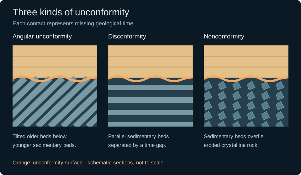
Erosional or nondepositional surface separating younger beds from older beds tilted at a different angle.
Reference & related terms
SLB Energy Glossary — angular unconformityReference reviewed 2026-10-24
Related: Hiatus · Unconformity · Disconformity · Nonconformity · Conformable succession
View schematic: Unconformity geometries
View in the Oilfield Glossary →
Anhydrite
Anhydrous calcium-sulfate mineral and associated evaporite rock that may form sealing intervals.
Reference & related terms
SLB Energy Glossary — anhydriteReference reviewed 2026-10-24
View in the Oilfield Glossary →
Anisotropy
Variation of a material property with measurement direction, such as different seismic velocities parallel and perpendicular to bedding.
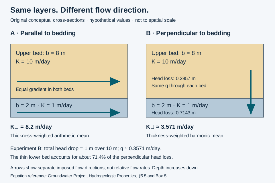
Interpretation note Name the property and scale: hydraulic anisotropy concerns conductivity, not necessarily seismic velocity or electrical resistivity. Isotropic beds can form an anisotropic layered unit.
Worked example: conductivity along and across layers
Reference & related terms
SLB Energy Glossary — anisotropyReference reviewed 2026-10-24
Related: Layered heterogeneity · Equivalent hydraulic conductivity · Isotropy · Hydraulic conductivity tensor
View schematic: Layer-parallel and layer-normal groundwater flow
View in the Oilfield Glossary →
Structural geology & tectonics# Anticline
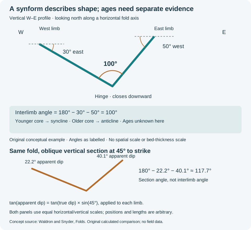
Fold with older beds in its core, commonly forming an upward arch that can create a structural hydrocarbon trap.
Interpretation note Separate fold shape from stratigraphic age: antiform and synform describe closure, whereas anticline and syncline require age evidence. Record the profile orientation before measuring limb angles.
Worked example: fold profile and bed age
Reference & related terms
SLB Energy Glossary — anticlineReference reviewed 2026-10-24
Additional clarification reference
Related: Fold · Fold axial plane · Fold hinge · Fold limb · Syncline · Antiform · Synform · Interlimb angle
View schematic: Fold profile: shape, limb angle and bed age
View in the Oilfield Glossary →
Structural geology & tectonics# Antiform
Upward-convex fold shape, without specifying the ages of its layers.
Interpretation note Separate fold shape from stratigraphic age: antiform and synform describe closure, whereas anticline and syncline require age evidence. Record the profile orientation before measuring limb angles.
Worked example: fold profile and bed age
Reference & related terms
BGS / JNCC — Geological Conservation Review 34 glossaryReference reviewed 2026-10-25
Additional clarification reference
Related: Fold · Fold axial plane · Fold hinge · Fold limb · Anticline · Syncline · Synform · Interlimb angle
View schematic: Fold profile: shape, limb angle and bed age
View in the Oilfield Glossary →
Igneous rocks & volcanology# Aphanitic texture
An igneous texture in which most crystals are too small to distinguish without magnification.
Reference & related terms
Steven Earle / BCcampus — Physical Geology: Classification of Igneous RockReference reviewed 2026-10-25
Structural geology & tectonics# Apparent dip
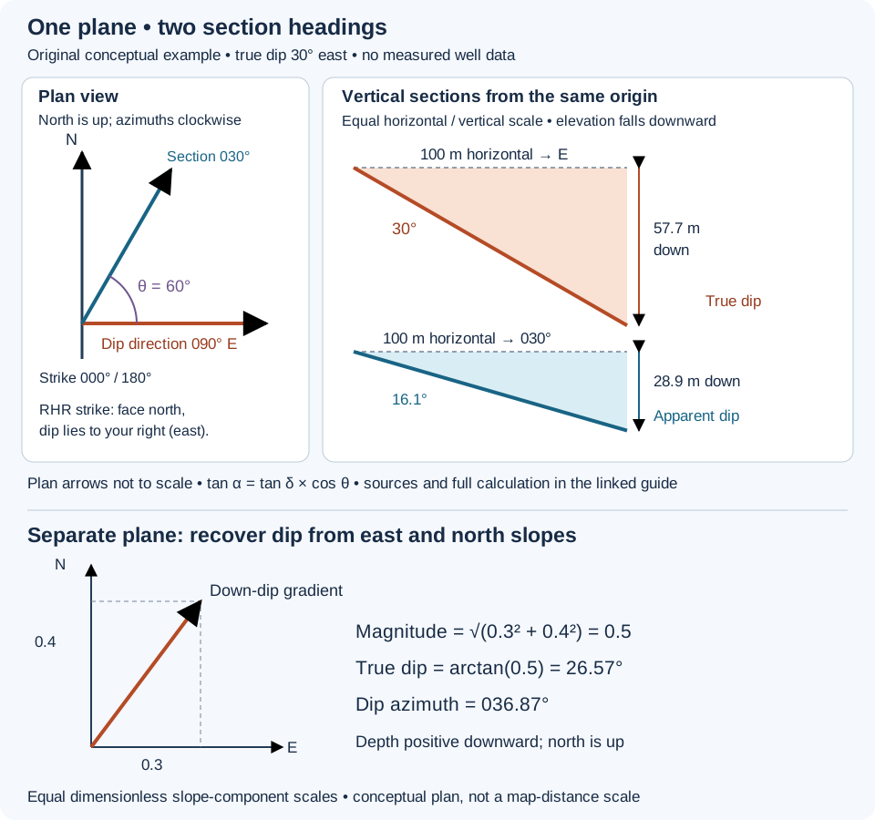
Inclination of a geological plane seen in a vertical section not aligned with its maximum-dip direction.
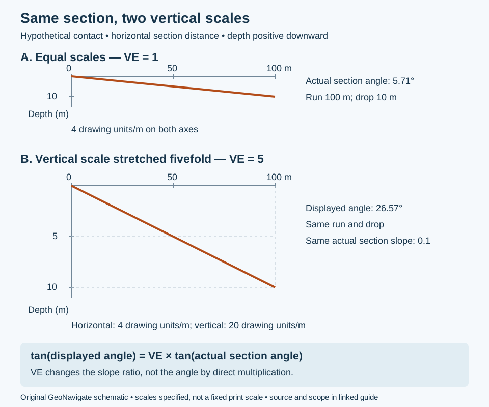
Interpretation note For a nonvertical plane, tan(apparent dip) = tan(true dip) × cos(theta), where theta is the horizontal angle from the down-dip direction to the section heading. A negative result means the surface rises along that heading. Two perpendicular signed section slopes of the same planar surface can recover its dip: combine their tangents as orthogonal components, rather than averaging the angles.
Worked example: recover dip from perpendicular sections
Reference & related terms
SLB Energy Glossary — Apparent dipReference reviewed 2026-10-25
Additional clarification reference
Related: Strike · Formation dip · True stratigraphic thickness · True vertical thickness · Dip direction · Right-hand rule · Vertical exaggeration
View schematic: Strike, dip direction and apparent dip
View in the Oilfield Glossary →
Hydrogeology & pore systems# Aquifer
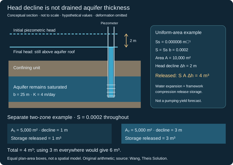
Water-bearing permeable rock or sediment capable of transmitting water; an adjoining aquifer may support reservoir pressure.
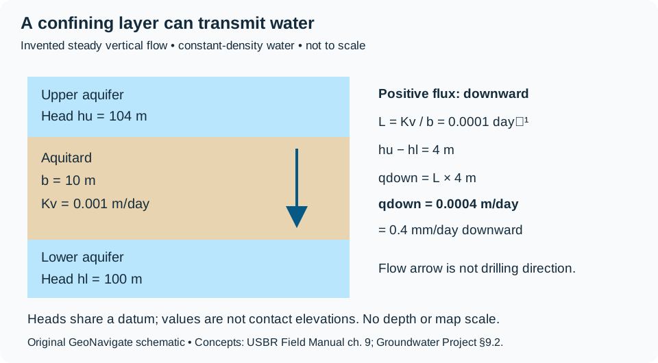
Worked example: aquifers separated by a leaky layer
Reference & related terms
SLB Energy Glossary — aquiferReference reviewed 2026-10-24
Related: Groundwater · Water table · Unconfined aquifer · Confined aquifer · Artesian condition · Aquitard · Vertical leakance
View schematic: Head-driven leakage across an aquitard
View in the Oilfield Glossary →
Sedimentology & sedimentary rocks# Arenaceous
Containing sand-sized material or having a sandy texture; does not by itself specify quartz content.
Also called: Sandy
Reference & related terms
SLB Energy Glossary — arenaceousReference reviewed 2026-10-25
Geomorphology & glacial geology# Arete
A narrow ridge sharpened by erosion in adjacent glacial valleys or cirques.
Also called: Arête
Reference & related terms
Virginia Tech — Introduction to Earth Science: GlaciersReference reviewed 2026-10-25
Sedimentology & sedimentary rocks# Argillaceous
Containing fine muddy material, commonly clay minerals; used as a compositional or textural rock descriptor.
Also called: Clay-rich
Reference & related terms
SLB Energy Glossary — argillaceousReference reviewed 2026-10-25
Hydrogeology & pore systems# Artesian condition
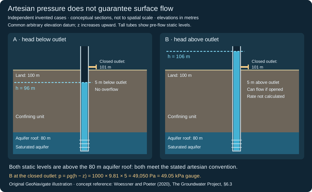
Confined groundwater pressure that raises water above the aquifer top in a well; surface flow is not required.
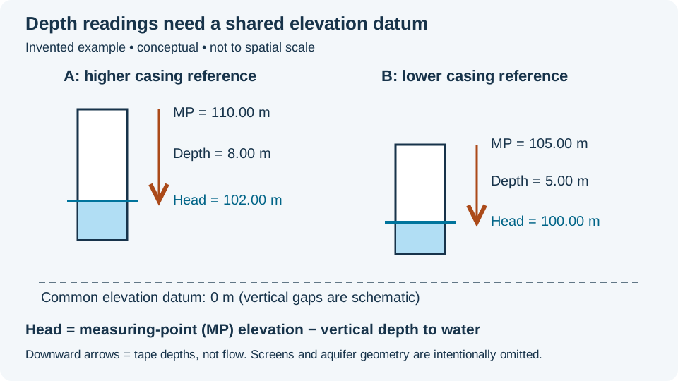
Interpretation note Compare static head with both the aquifer roof and the discharge outlet using the same elevation datum. A level above the roof can remain below land. Head above an outlet indicates discharge potential, but does not determine flow rate.
Worked example: artesian head and surface flow
Also called: Artesian pressure
Reference & related terms
USGS Water Science School — Water Science GlossaryReference reviewed 2026-10-29
Additional clarification reference
Related: Aquifer · Groundwater · Water table · Unconfined aquifer · Confined aquifer · Potentiometric surface
View schematic: Artesian head versus outlet elevation
View in the Oilfield Glossary →
Structural geology & tectonics# Asthenosphere
Relatively weak, deformable upper mantle beneath the lithosphere; predominantly solid despite possible small melt fractions.
Reference & related terms
Karla Panchuk / BCcampus — Earth’s layersReference reviewed 2026-10-25
Related: Tectonic plate · Lithosphere · Crust · Mantle
Sedimentology & sedimentary rocks# Authigenic
Describes minerals formed in place within a rock, rather than transported into it as sediment grains.
Reference & related terms
SLB Energy Glossary — authigenicReference reviewed 2026-10-24
View in the Oilfield Glossary →
Hydrogeology & pore systems# Average linear groundwater velocity
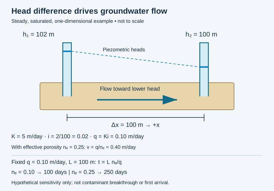
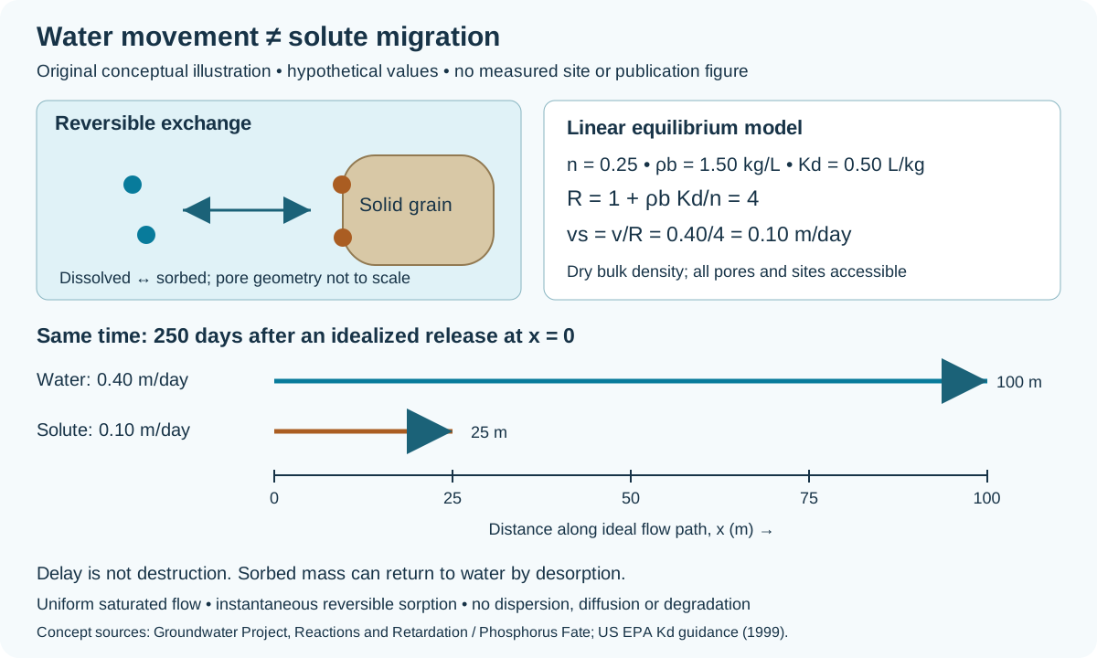
Mean advective groundwater speed estimated as v = q/ne, where q is Darcy flux and ne is effective flow porosity. This averages pore paths and does not include dispersion or solute retardation.
Interpretation note For uniform steady flow, t = L ne/q. State the flow-porosity assumption and test its sensitivity; this time is not a first-arrival or contaminant-breakthrough prediction.
Worked example: flow porosity and travel-time sensitivity
Also called: Seepage velocity, Average pore-water velocity
Reference & related terms
The Groundwater Project — groundwater flow principlesReference reviewed 2026-10-29
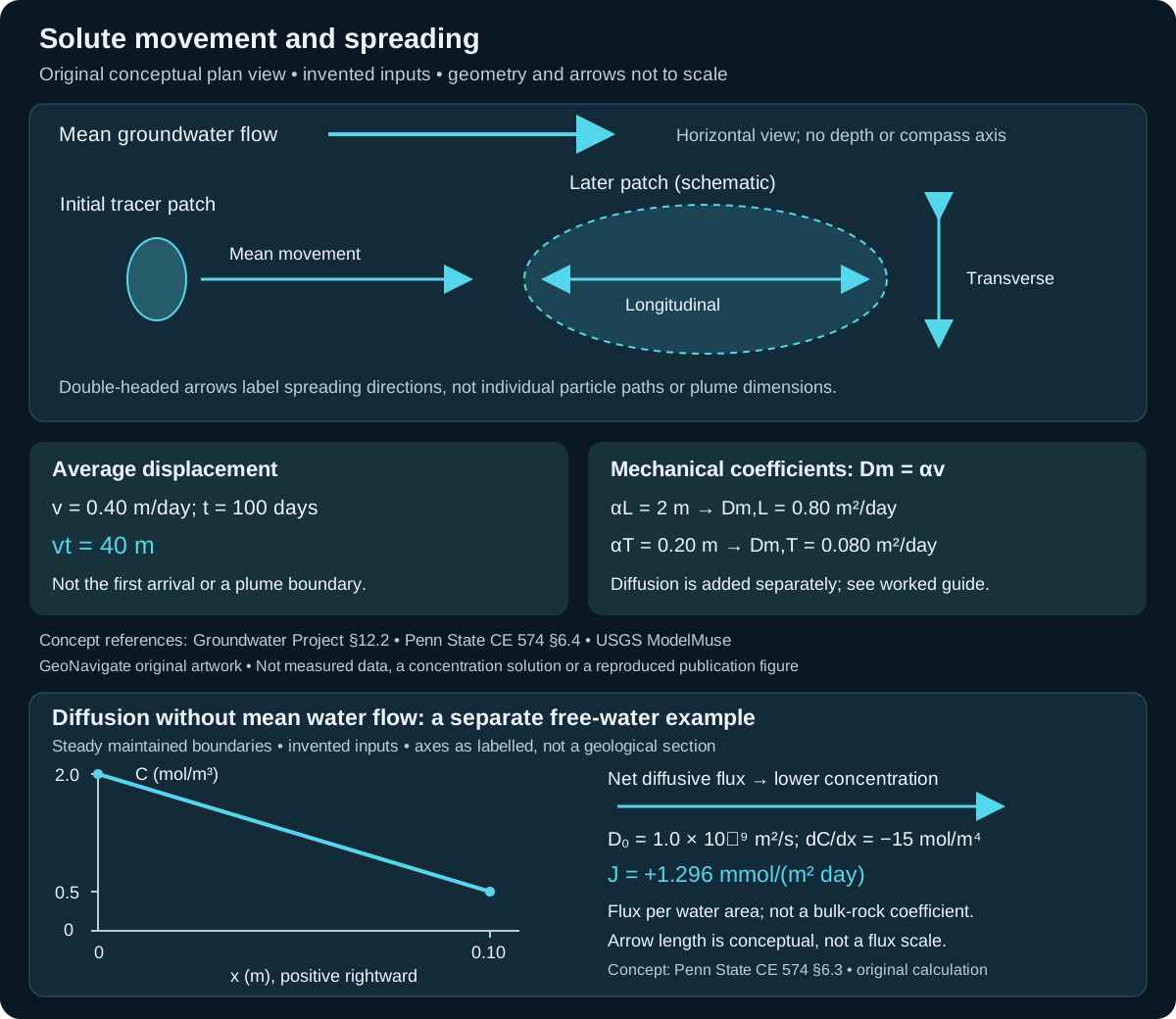
Related: Hydraulic head · Hydraulic gradient · Darcy flux · Sorption · Sorption distribution coefficient · Retardation factor · Mechanical dispersion · Dispersivity
View schematic: Groundwater head loss and Darcy flux
View in the Oilfield Glossary →
Wellsite geology & samples# Background gas BGG
Baseline mud-gas level under reasonably steady drilling conditions, used to compare departures from the prevailing trend.
Reference & related terms
SLB Energy Glossary — Background gasReference reviewed 2026-10-24
View in the Oilfield Glossary →
Sedimentology & sedimentary rocks# Bafflestone
Boundstone in which organisms slowed flow and trapped sediment.
Reference & related terms
IODP Expedition 359 — sediment and rock classificationReference reviewed 2026-10-25
Related: Rudstone · Floatstone · Boundstone · Bindstone · Framestone
Igneous rocks & volcanology# Basalt
A generally dark, iron- and magnesium-rich volcanic rock with relatively low silica content.
Reference & related terms
USGS — Volcano Hazards Program GlossaryReference reviewed 2026-10-25
Related: Gabbro · Mafic
Structural geology & tectonics# Basement
Older rock foundation beneath a sedimentary succession, commonly crystalline igneous or metamorphic rock.
Reference & related terms
SLB Energy Glossary — basementReference reviewed 2026-10-24
View in the Oilfield Glossary →
Igneous rocks & volcanology# Batholith
A large composite intrusive body with more than 100 square kilometres of surface exposure.
Reference & related terms
Steven Earle / BCcampus — Physical Geology: Intrusive Igneous BodiesReference reviewed 2026-10-25
Related: Pluton · Stock
Stratigraphy & correlation# Bed
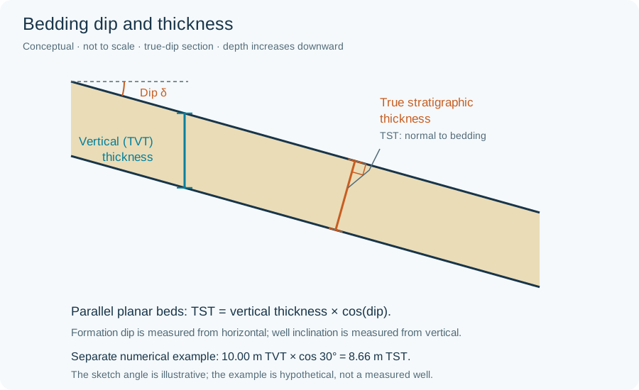
A distinct sedimentary layer; when formally named, the smallest ranked sedimentary lithostratigraphic unit.
Reference & related terms
International Commission on Stratigraphy — Lithostratigraphic unitsReference reviewed 2026-10-24
Related: Formation · Member · Group · Supergroup · Lithostratigraphy · Lithostratigraphic unit
View schematic: Bedding dip and thickness
View in the Oilfield Glossary →
Sedimentology & sedimentary rocks# Bedding
Arrangement of sediment or rock into layers separated by identifiable boundaries.
Reference & related terms
Texas A&M Ocean Drilling Program — Sedimentary rock classificationReference reviewed 2026-10-24
Related: Flexural slip · Flexural flow
View schematic: Bedding dip and thickness
View in the Oilfield Glossary →
Sedimentology & sedimentary rocks# Bindstone
Boundstone in which encrusting or binding organisms stabilized sediment.
Reference & related terms
IODP Expedition 359 — sediment and rock classificationReference reviewed 2026-10-25
Related: Rudstone · Floatstone · Boundstone · Bafflestone · Framestone
Stratigraphy & correlation# Biostratigraphy
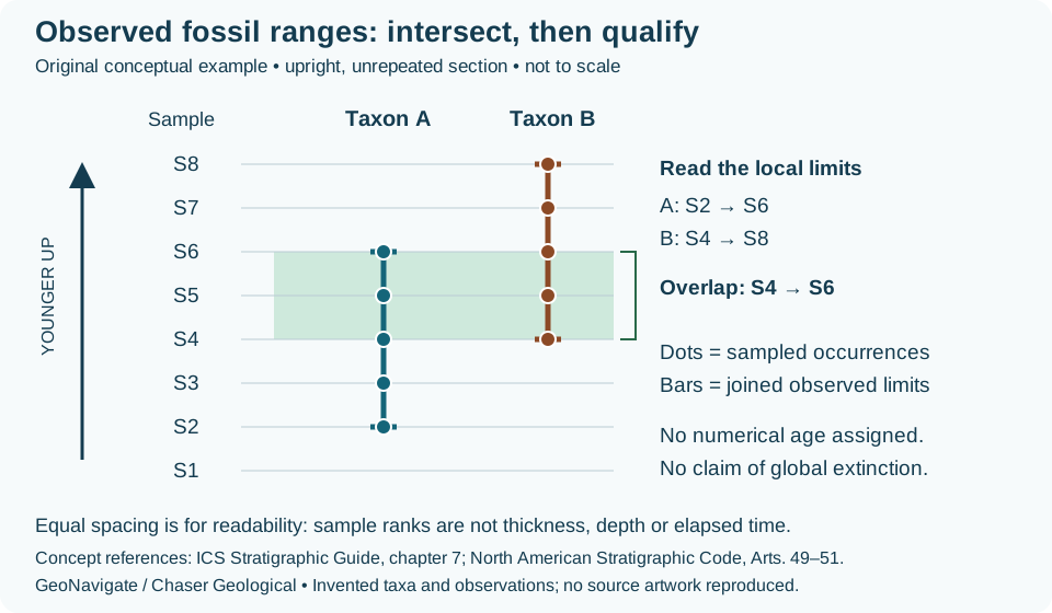
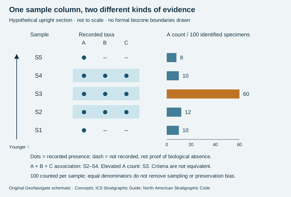
Use of fossils to date and correlate sedimentary intervals and help interpret depositional environments.
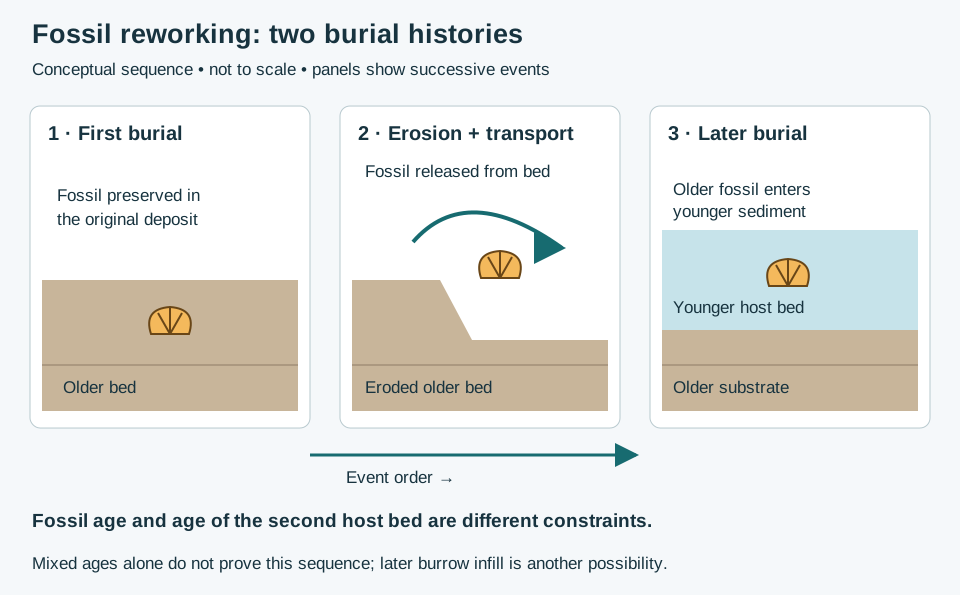
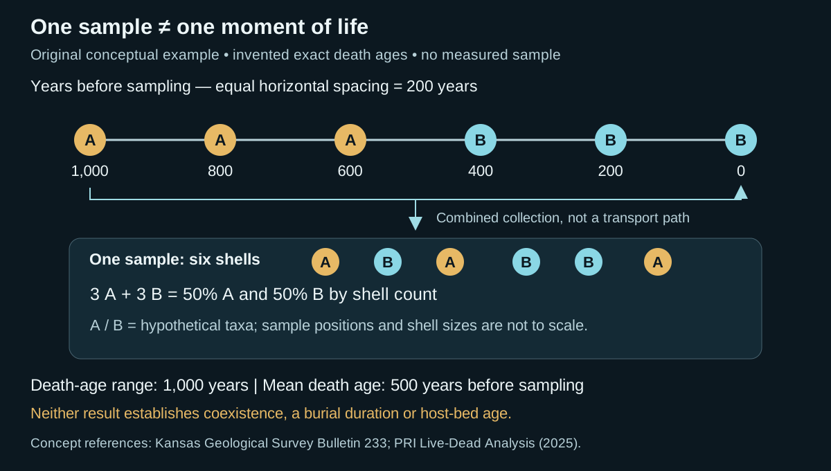
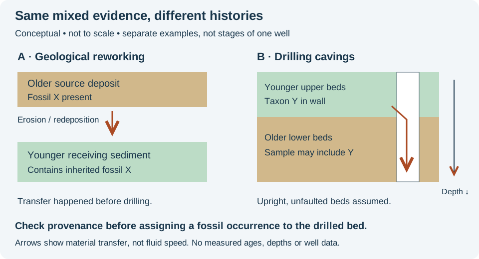
Interpretation note Check assemblage consistency and possible reworking before assigning a host-bed age from a fossil occurrence. State whether a reported range is local or compiled across sections; correlation requires an explicit zonal criterion. Reworking is a depositional history; drilling cavings are sample contamination. Do not interpret a mixed fossil assemblage until these possibilities have been considered.
Worked example: reworking versus drilling cavings
Reference & related terms
SLB Energy Glossary — biostratigraphyReference reviewed 2026-10-24
Additional clarification reference
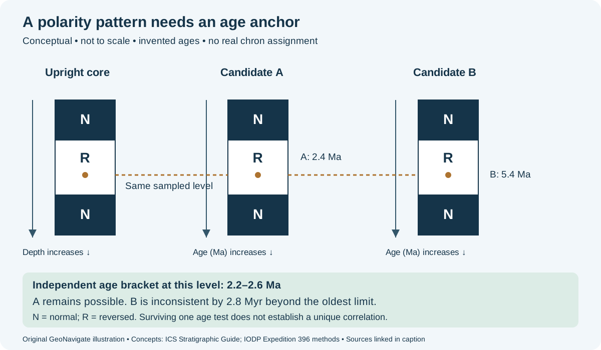
Related: Reworked fossil · Fossil disarticulation · Polarity zone · Polarity chron · Fossil time averaging · Death assemblage · Taxon-range zone · Concurrent-range zone · Cavings · Assemblage biozone · Abundance biozone · Lineage biozone · Barren interval
Additional schematic: Fossil reworking and drilling cavings
View schematic: Fossil reworking: two burial histories
View in the Oilfield Glossary →
Biotite
A dark mica group containing iron and magnesium, with a sheet structure and excellent basal cleavage.
Reference & related terms
Steven Earle / BCcampus — Physical Geology: Silicate MineralsReference reviewed 2026-10-25
Sedimentology & sedimentary rocks# Bioturbation
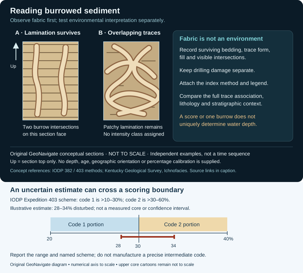
Disturbance and mixing of sediment by organisms, often expressed as burrows or disrupted bedding.
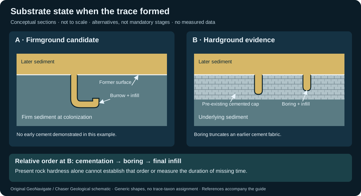
Reference & related terms
Texas A&M Ocean Drilling Program — Sedimentary rock classificationReference reviewed 2026-10-24
Related: Firmground · Hardground · Ichnofabric · Ichnofacies
View schematic: Firm and lithified substrates at colonization
View in the Oilfield Glossary →
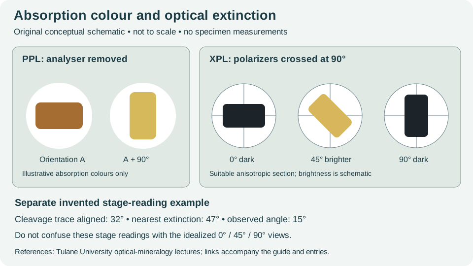
Birefringence
The optical property whereby light passing through an anisotropic crystal separates into components travelling at different speeds.
Complementary optical identification observations
Also called: Double refraction
Reference & related terms
Virginia Tech — Introduction to Earth Science: MineralsReference reviewed 2026-10-25
Related: Pleochroism · Optical extinction · Extinction angle
View schematic: Absorption colour and crossed-polar extinction
Body fossil
Preserved evidence of an organism's physical body, rather than solely its activity.
Interpretation note A body fossil may retain connected parts or consist of isolated elements; record this observation separately from identification.
Fossil preservation and reworking: worked interpretation
Reference & related terms
National Park Service — How Fossils FormReference reviewed 2026-10-25
Related: Fossil · Trace fossil · Taphonomy · Fossil mould · Reworked fossil · Fossil disarticulation
Structural geology & tectonics# Boudinage
Extension that segments a relatively competent layer into separated, sausage-like bodies.
Reference & related terms
BGS / JNCC — Geological Conservation Review 34 glossaryReference reviewed 2026-10-25
Sedimentology & sedimentary rocks# Boulder
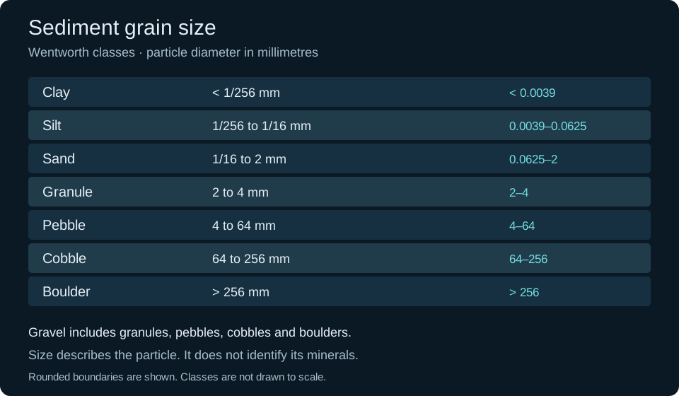
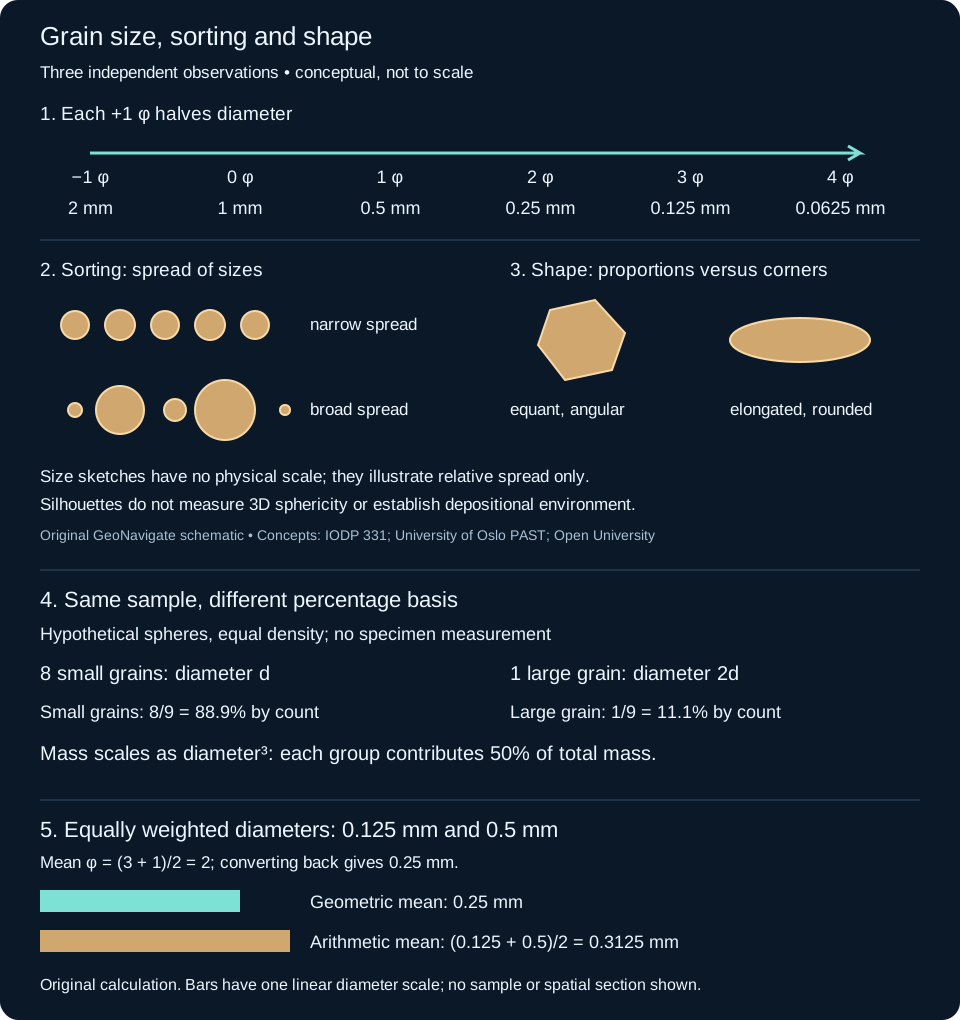
Gravel particle larger than 256 mm on the Wentworth scale.
Reference & related terms
USGS Bulletin 1046-Q — Wentworth grain-size classification, table 1Reference reviewed 2026-10-25
Related: Granule · Pebble · Cobble · Gravel
View schematic: Wentworth grain-size classes
Sedimentology & sedimentary rocks# Boundstone
Carbonate material bound together by organisms during deposition.
Reference & related terms
IODP Expedition 359 — sediment and rock classificationReference reviewed 2026-10-25
Related: Mudstone · Carbonate mudstone · Wackestone · Packstone · Grainstone · Rudstone
View schematic: Carbonate depositional textures
Sedimentology & sedimentary rocks# Breccia
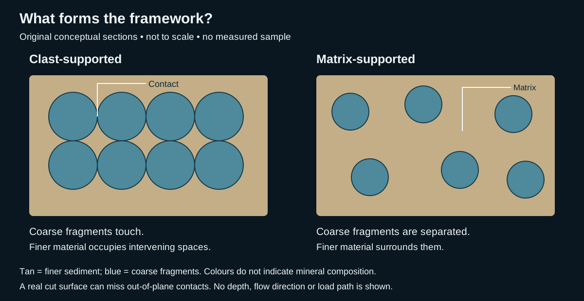
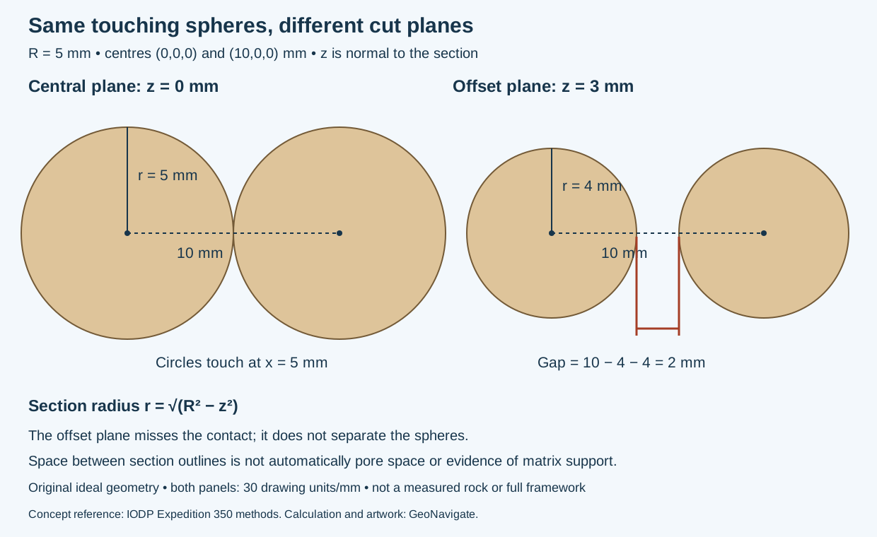
Rock composed of angular fragments bound together; the fragment origin and surrounding material determine its geological interpretation.
Reference & related terms
USGS — Lithologic classification of geologic map unitsReference reviewed 2026-10-24
Related: Clast-supported texture · Matrix-supported texture
View schematic: Clast support versus matrix support
View in the Oilfield Glossary →
Bright spot
Locally strong seismic amplitude that may indicate hydrocarbons but can also result from lithology or thin-bed interference.
Reference & related terms
SLB Energy Glossary — bright spotReference reviewed 2026-10-24
View in the Oilfield Glossary →
Wellsite geology & samples# Calcimetry
Estimation of carbonate content from a sample's reaction under a defined analytical method. Report the method and whether the result represents calcite, dolomite or total carbonate.
Reference & related terms
Energistics WITSML — CuttingsGeologyIntervalReference reviewed 2026-10-24
View in the Oilfield Glossary →
Calcite
Calcium-carbonate mineral that is a major constituent of limestone and a common cement in sedimentary rocks.
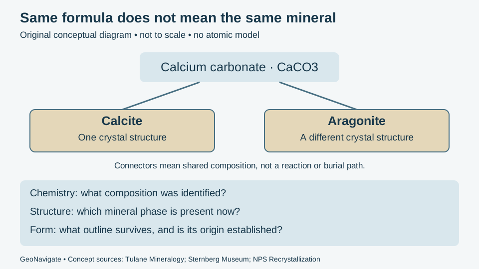
Interpretation note Calcite and aragonite share the ideal formula CaCO3 but differ in crystal structure. Calcite identified in a fossil is not by itself proof that the organism originally secreted calcite.
Worked identification: composition versus crystal structure
Reference & related terms
SLB Energy Glossary — calciteReference reviewed 2026-10-24
Additional clarification reference
Related: Dolomite mineral · Limestone · Dolostone · Marble · Aragonite · Polymorphism
View schematic: Same composition, different mineral structures
View in the Oilfield Glossary →
Igneous rocks & volcanology# Caldera
A broad, basin-shaped volcanic depression substantially wider than the individual vents within it.
Reference & related terms
USGS — Volcano Hazards Program GlossaryReference reviewed 2026-10-25
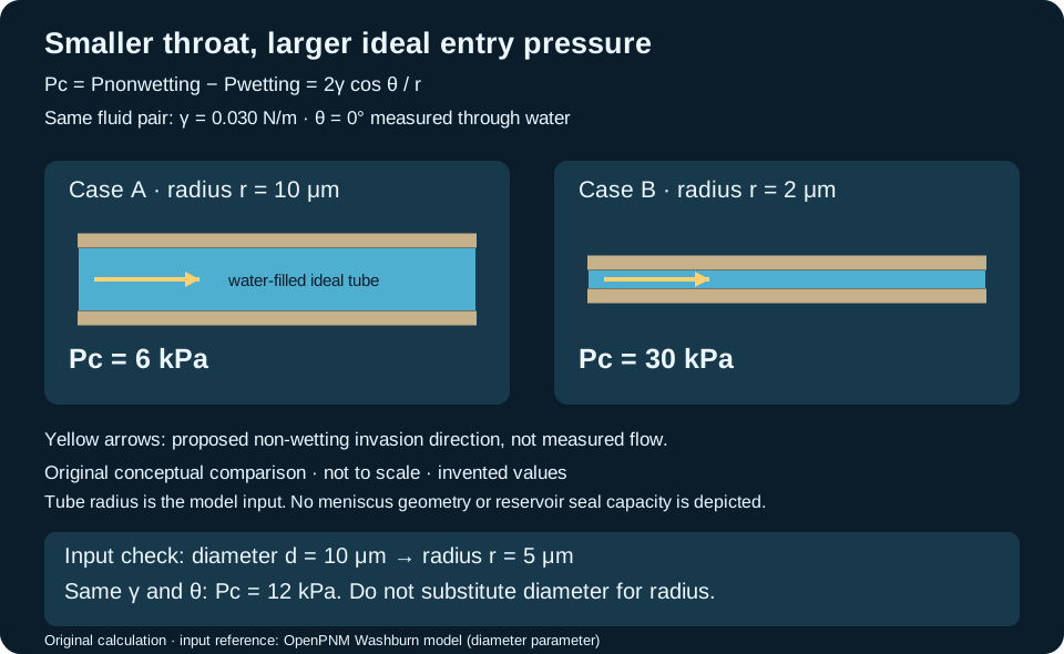
Hydrogeology & pore systems# Capillary entry pressure
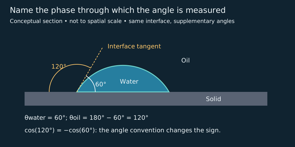
Threshold pressure difference at which a non-wetting fluid first invades an accessible, initially wetting-fluid-filled pore connection under a specified displacement path. Geometry, interfacial tension and wetting conditions control the threshold.
Interpretation note Check whether a measured throat size is radius or diameter. In the ideal tube model, a 10 μm diameter means r = 5 μm, giving 12 kPa for γ = 0.030 N/m and water-side θ = 0°. Treating that diameter as radius incorrectly gives 6 kPa. Preserve phase order and angle convention when transferring software inputs.
Worked example: radius versus diameter
Also called: Entry capillary pressure
Reference & related terms
Idaho National Laboratory FALCON — Capillary pressureReference reviewed 2026-10-30
Related: Wettability · Capillary pressure
View schematic: Pore-throat radius and capillary entry
View in the Oilfield Glossary →
Hydrogeology & pore systems# Capillary pressure
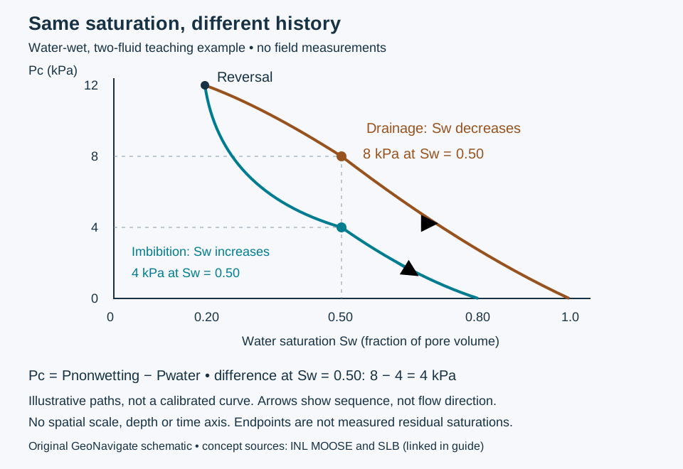
Pressure difference across a fluid interface. Here Pc is non-wetting-phase pressure minus wetting-phase pressure; always state the phase order because sign conventions differ.
Capillary entry: worked pore-throat example
Also called: Pc
Reference & related terms
Idaho National Laboratory FALCON — Capillary pressureReference reviewed 2026-10-25
Related: Wettability · Capillary entry pressure · Drainage displacement · Imbibition · Capillary-pressure hysteresis
View schematic: Pore-throat radius and capillary entry
View in the Oilfield Glossary →
Sedimentology & sedimentary rocks# Carbonate mudstone
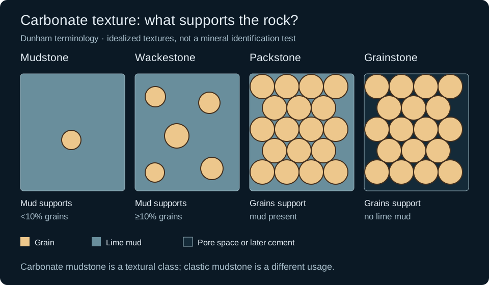
Mud-supported carbonate rock with fewer than 10% grains in the Dunham classification; distinct from clastic mudstone.
Also called: Lime mudstone
Reference & related terms
IODP Expedition 359 — sediment and rock classificationReference reviewed 2026-10-25
Related: Mudstone · Wackestone · Packstone · Grainstone · Boundstone
View schematic: Carbonate depositional textures
Carbonization
Fossilization in which decomposition removes volatile components and leaves a carbon-rich residue.
Also called: Carbonisation
Reference & related terms
National Park Service — Impressions and CompressionsReference reviewed 2026-10-25
Petroleum geology & geochemistry# Catagenesis
Burial-related thermal alteration of organic matter and sediments beyond early diagenesis, including important stages of petroleum generation.
Reference & related terms
SLB Energy Glossary — catagenesisReference reviewed 2026-10-24
Related: Kerogen · Thermal maturity · Total organic carbon · Vitrinite reflectance
View in the Oilfield Glossary →
Wellsite geology & samples# Cavings
Fragments detached from the borehole wall rather than newly drilled at the bit; they can contaminate cuttings samples.
Interpretation note Material from an interval penetrated earlier need not be geologically older. In an upright, unfaulted succession, younger fossils can cave from above into a sample collected while drilling older beds. Folded or faulted sections require their own age-order model.
Worked example: reworking versus drilling cavings
Reference & related terms
SLB Energy Glossary — CavingsReference reviewed 2026-10-24
Additional clarification reference
Related: Cuttings · Lag time · Cuttings description · Sample provenance · Reworked fossil · Biostratigraphy
Additional schematic: Fossil reworking and drilling cavings
View schematic: Fossil reworking and drilling cavings
View in the Oilfield Glossary →
Sedimentology & sedimentary rocks# Chalk
Fine-grained marine limestone largely composed of microscopic calcareous skeletal material.
Reference & related terms
SLB Energy Glossary — chalkReference reviewed 2026-10-24
View in the Oilfield Glossary →
Checkshot survey
Borehole survey measuring travel time from a surface seismic source to receivers at known depths to calibrate time-depth relationships.
Interpretation note Checkshot first arrivals provide source-to-receiver times, not automatically surface-reflection two-way times. Survey geometry, well deviation and seismic reference datum corrections must be reconciled before using the resulting time–depth relationship for a well tie.
Worked example: two layers, travel time and depth
Also called: Check-shot survey
Reference & related terms
SLB Energy Glossary — check-shot surveyReference reviewed 2026-10-24
Related: Average seismic velocity · Depth conversion
View schematic: Two layers: travel time and depth are different coordinates
View in the Oilfield Glossary →
Geological time & dating# Chemostratigraphy
Correlation and subdivision of rock successions using variations in chemical composition or isotopic signatures.
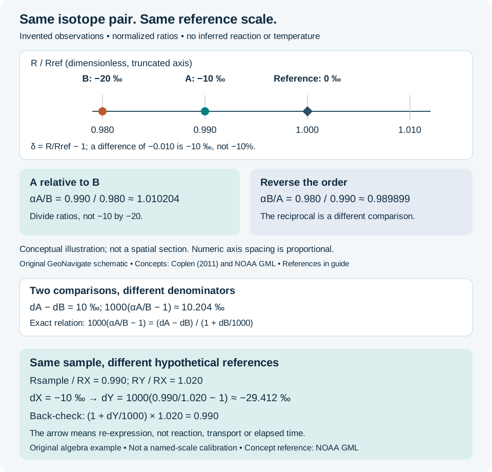
Interpretation note An isotope excursion requires a common reference scale and checks for alteration and sample comparability before it is used for correlation.
Stable-isotope comparisons and interpretation limits
Reference & related terms
Minnesota Geological Survey — Geologic TimeReference reviewed 2026-10-25
Additional clarification reference
Related: Isotope delta · Isotope fractionation · Diagenesis · Stratigraphic correlation
View schematic: Isotope delta: compare ratios on the same reference scale
Sedimentology & sedimentary rocks# Chert CHT
Hard, very fine-crystalline silica-rich rock, often found as nodules or layers within sedimentary successions.
Reference & related terms
SLB Energy Glossary — ChertReference reviewed 2026-10-24
Related: Quartz · Sandstone · Quartzite
View in the Oilfield Glossary →
Structural geology & tectonics# Chevron fold
Fold with straight limbs meeting at a sharp hinge.
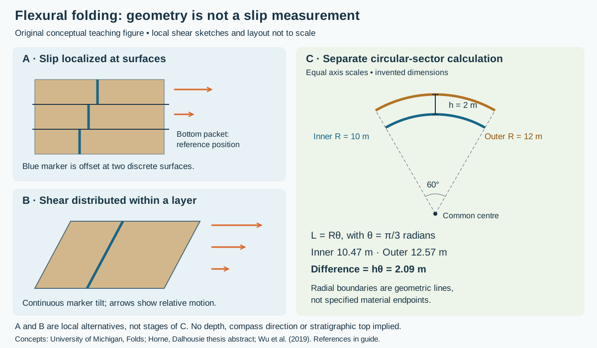
Worked folding geometry and slip evidence
Reference & related terms
BGS / JNCC — Geological Conservation Review 34 glossaryReference reviewed 2026-10-25
Related: Flexural slip · Flexural flow
View schematic: Folding: localized slip, distributed shear and arc lengths
Chlorite
Platy green silicate mineral that can occur as pore-lining coatings in sandstone and influence reservoir quality.
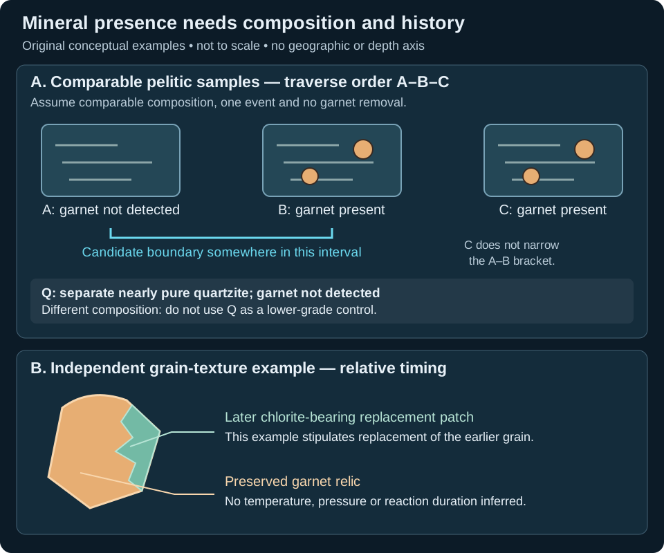
Interpretation note Chlorite can belong to an earlier low-grade assemblage or form during later replacement. Report its texture and associated minerals before interpreting metamorphic history.
Worked guide: mineral evidence, isograds and overprints
Reference & related terms
SLB Energy Glossary — chloriteReference reviewed 2026-10-24
Additional clarification reference
Related: Isograd · Retrograde metamorphism
View schematic: Isograd evidence and a later mineral overprint
View in the Oilfield Glossary →
Stratigraphy & correlation# Chronostratigraphic correlation
Correlation intended to connect intervals of equivalent geological age. It differs from matching similar rock types, which may occur at different times in different locations.
Reference & related terms
SLB Energy Glossary — correlationReference reviewed 2026-10-24
View in the Oilfield Glossary →
Stratigraphy & correlation# Chronostratigraphy
Classification and correlation of rock bodies according to their relative or absolute ages.
Reference & related terms
SLB Energy Glossary — chronostratigraphyReference reviewed 2026-10-24
View in the Oilfield Glossary →
Geomorphology & glacial geology# Cirque
A bowl-shaped erosional hollow at the head of a glaciated valley.
Reference & related terms
Virginia Tech — Introduction to Earth Science: GlaciersReference reviewed 2026-10-25
Related: Tarn · Arete
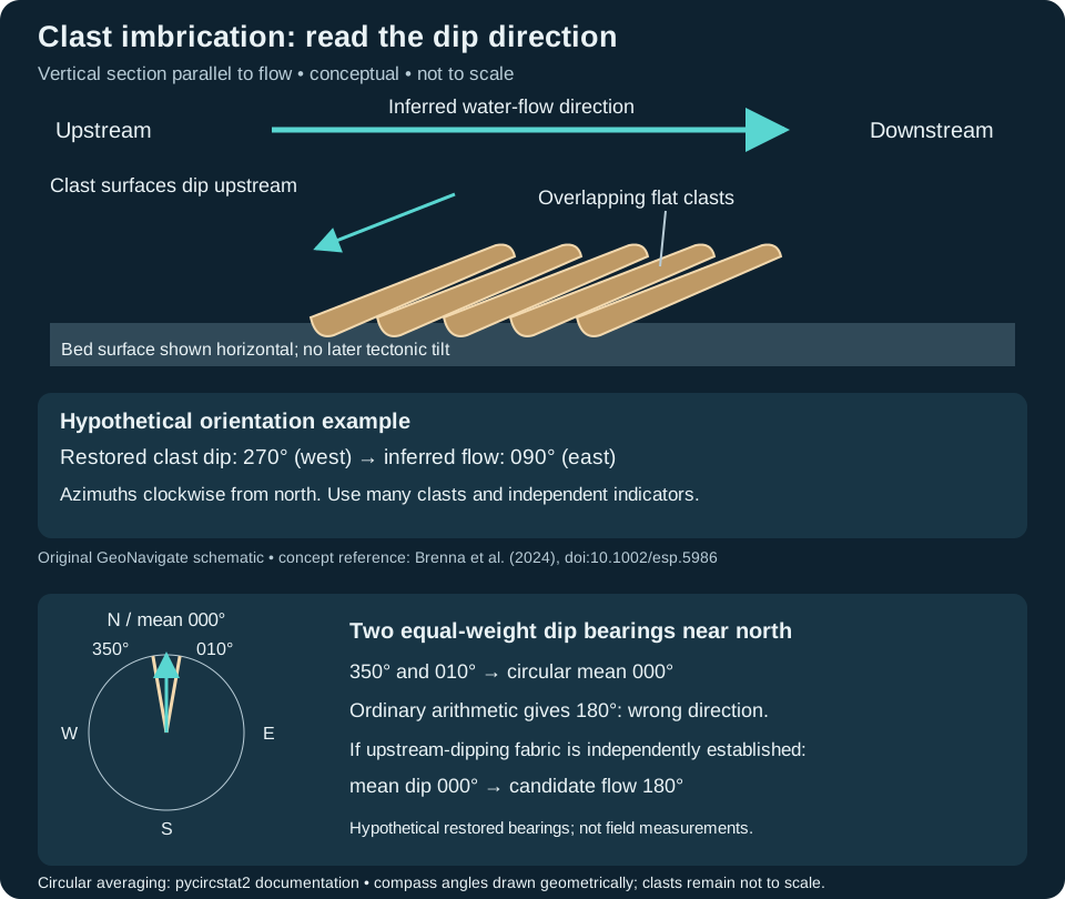
Sedimentology & sedimentary rocks# Clast imbrication
An overlapping, preferentially inclined arrangement of sedimentary clasts. In the common upstream-dipping fabric, the broad clast surfaces dip against the inferred flow direction; long-axis orientation must be recorded separately.
Interpretation note Average dip azimuths as circular directions, not ordinary numbers. Keep measured dip directions, inferred flow directions and undirected long-axis orientations distinct; a circular mean is not a bedding-restoration calculation.
Worked example: averaging bearings across north
Also called: Pebble imbrication, Imbricated clasts
Reference & related terms
Brenna et al. (2024) — Imbrication fabric and gravel transport processesReference reviewed 2026-10-29
Related: Paleocurrent · Conglomerate · Cross-bedding
View schematic: Clast imbrication and inferred flow
View in the Oilfield Glossary →
Hydrogeology & pore systems# Clay-bound water CBW
Water associated with clay surfaces or interlayers that is generally immobile and commonly excluded from log-derived effective porosity.
Reference & related terms
SLB Energy Glossary — clay-bound waterReference reviewed 2026-10-24
View in the Oilfield Glossary →
Sedimentology & sedimentary rocks# Clay-size sediment
Particles smaller than 1/256 mm (about 3.9 micrometres) on the Wentworth scale; size alone does not establish mineral composition.
Also called: Clay size
Reference & related terms
USGS Bulletin 1046-Q — Wentworth grain-size classification, table 1Reference reviewed 2026-10-25
Related: Sand · Silt · Gravel · Grain size · Udden-Wentworth scale
View schematic: Wentworth grain-size classes
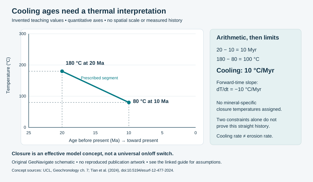
Geological time & dating# Closed isotopic system
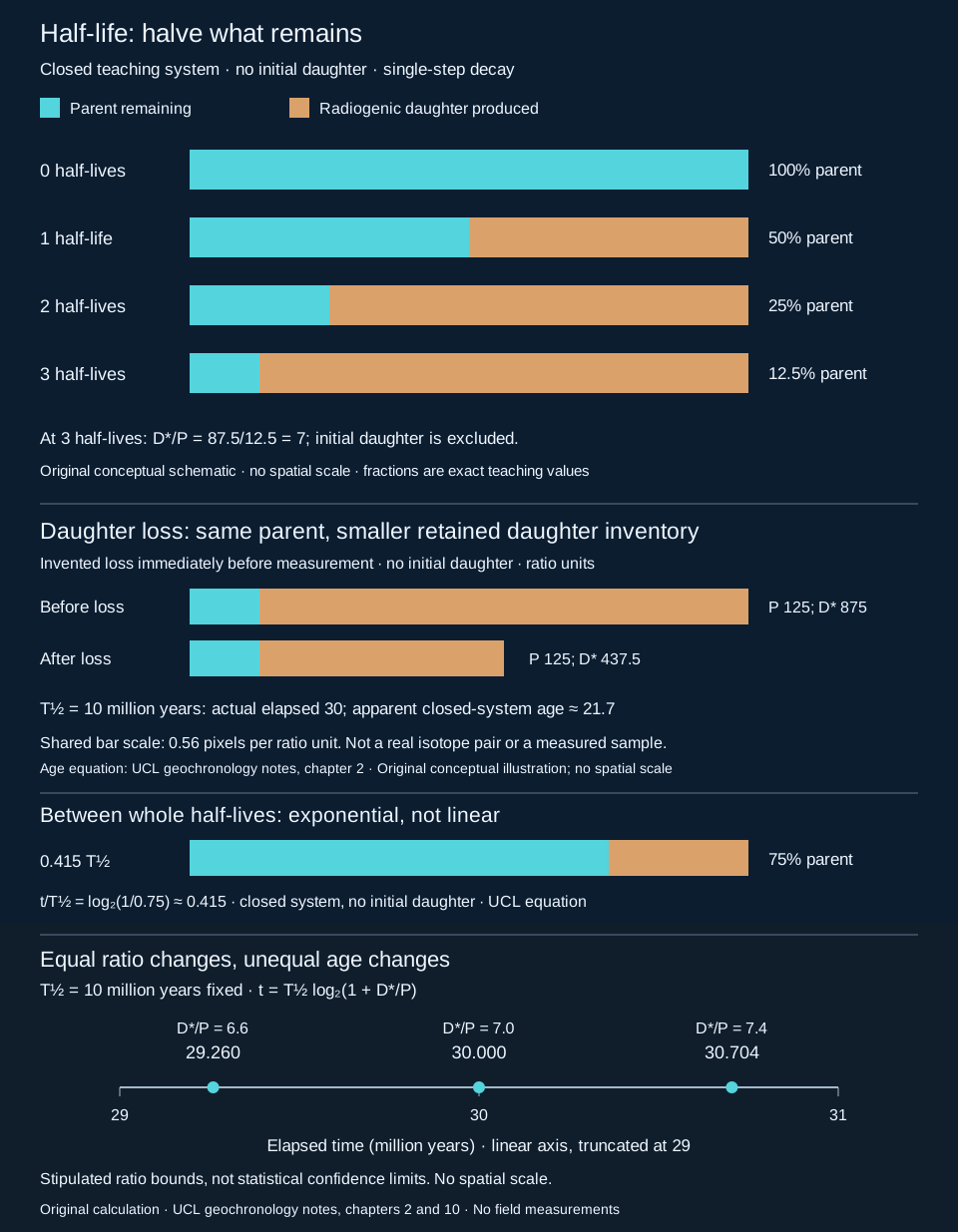
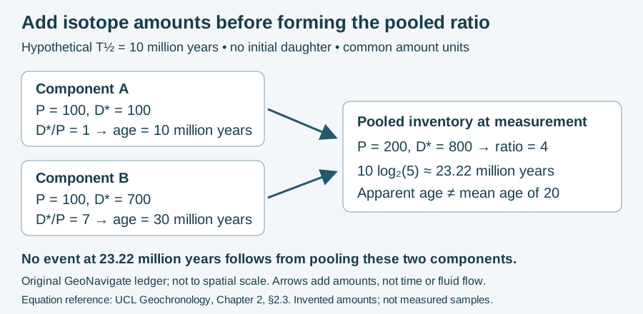
A mineral or rock domain that has neither gained nor lost the relevant parent or daughter isotopes over the interval being dated, apart from internal radioactive decay. Closure is specific to an isotope system and geological history.
Interpretation note A lower retained daughter/parent ratio can reflect daughter loss rather than a younger formation event. The worked loss example holds parent constant; it is not a universal correction for disturbed samples.
Worked example: daughter loss and apparent age
Reference & related terms
USGS — Radiogenic IsotopesReference reviewed 2026-10-29
Additional clarification reference
Related: Radiometric dating · Parent isotope · Daughter isotope · Half-life · Radiogenic isotope · Thermochronology · Closure temperature
View schematic: Radioactive decay in a closed teaching system
View in the Oilfield Glossary →
Sedimentology & sedimentary rocks# Coal
Organic-rich sedimentary rock formed as buried plant material changes during coalification. It may contain or generate natural gas.
Reference & related terms
SLB Energy Glossary — CoalReference reviewed 2026-10-24
View in the Oilfield Glossary →
Sedimentology & sedimentary rocks# Cobble
Gravel particle in the 64–256 mm Wentworth size class.
Reference & related terms
USGS Bulletin 1046-Q — Wentworth grain-size classification, table 1Reference reviewed 2026-10-25
Related: Granule · Pebble · Boulder · Gravel
View schematic: Wentworth grain-size classes
Common midpoint CMP
Surface midpoint shared by multiple source-receiver pairs whose seismic traces are grouped for processing.
Reference & related terms
SLB Energy Glossary — common midpointReference reviewed 2026-10-24
View in the Oilfield Glossary →
Sedimentology & sedimentary rocks# Compaction
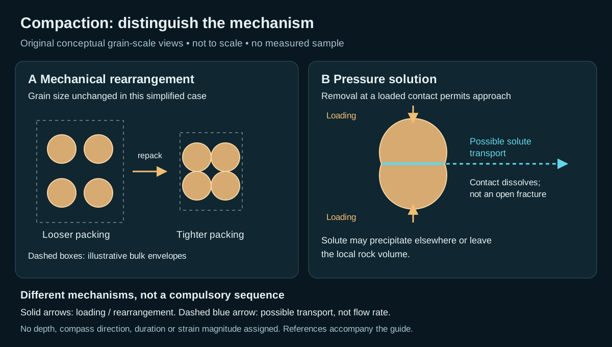
Reduction of sediment volume as grains pack more closely or deform, commonly decreasing pore space during burial.
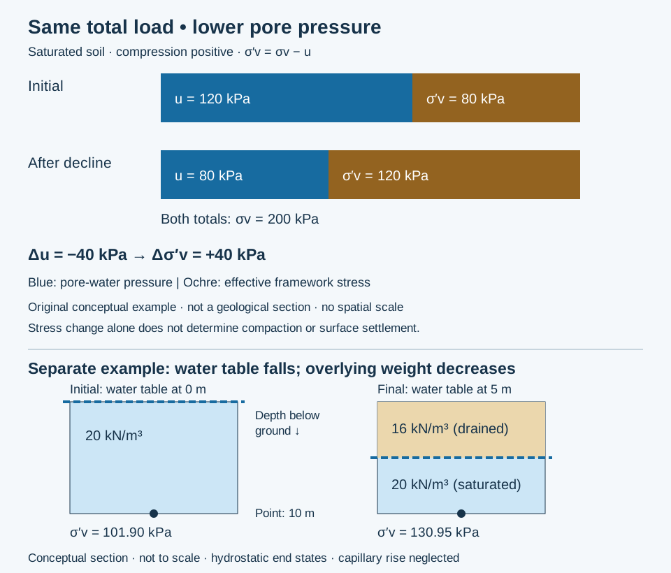
Interpretation note A pore-pressure decline can increase effective stress even without additional burial. Predicting deformation also requires compressibility, stress history and drainage times; the stress change alone does not give a settlement.
Effective stress and compaction: worked example
Reference & related terms
SLB Energy Glossary — CompactionReference reviewed 2026-10-24
Related: Effective stress · Pore-water pressure · Total vertical stress · Preconsolidation stress · Mechanical compaction · Pressure solution
View schematic: Effective stress during pore-pressure decline
View in the Oilfield Glossary →
Wellsite geology & samples# Composite well log
Combined presentation of selected geological observations and measurements on a common well and depth reference. Data sources and any alignment adjustments should remain identifiable.
Reference & related terms
SLB Energy Glossary — well logReference reviewed 2026-10-24
View in the Oilfield Glossary →
Compression fossil
Flattened organic remains preserving some chemically altered material, commonly as a thin film.
Reference & related terms
National Park Service — Impressions and CompressionsReference reviewed 2026-10-25
Related: Carbonization · Impression fossil
Compressional wave P-wave
Elastic body wave in which particle motion is parallel to the direction of propagation.
Also called: P wave
Reference & related terms
SLB Energy Glossary — p-waveReference reviewed 2026-10-24
Related: Acoustic impedance · Shear wave · Seismic trace
View schematic: Acoustic impedance and seismic reflection
View in the Oilfield Glossary →
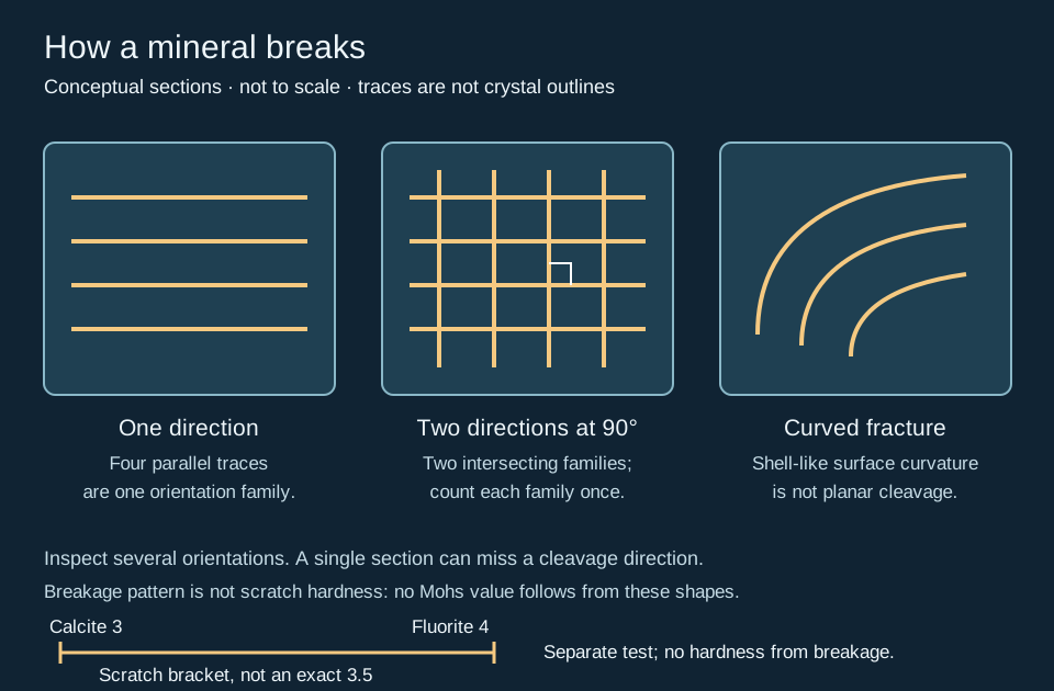
Conchoidal fracture
A mineral or glass breakage texture with curved, shell-like surfaces rather than repeated planar cleavage. Quartz commonly shows this texture, but the texture alone does not establish mineral identity.
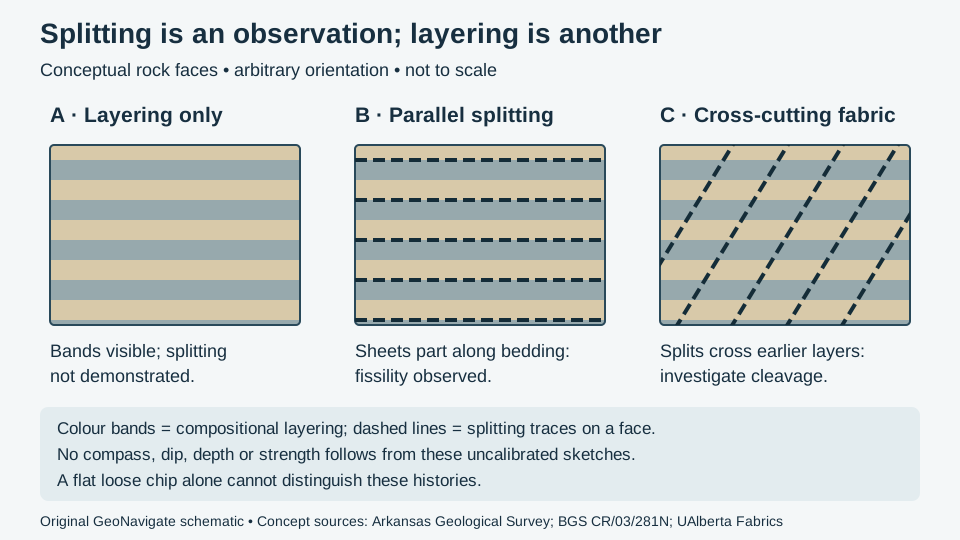
Mineral identification: cleavage, fracture and parting
Also called: Shell-like fracture
Reference & related terms
Oxford University Museum — Cleavage and fractureReference reviewed 2026-10-24
Related: Mineral fracture · Mineral parting
View schematic: Cleavage directions versus fracture
View in the Oilfield Glossary →
Stratigraphy & correlation# Condensed section
Thin sedimentary interval representing a long time span because deposition was unusually slow.
Reference & related terms
SLB Energy Glossary — condensed sectionReference reviewed 2026-10-24
View in the Oilfield Glossary →
Hydrogeology & pore systems# Confined aquifer
Aquifer beneath a confining layer, with water pressure sufficient to raise a well water level above its top.
Interpretation note Compare static head with both the aquifer roof and the discharge outlet using the same elevation datum. A level above the roof can remain below land. Head above an outlet indicates discharge potential, but does not determine flow rate.
Worked example: artesian head and surface flow
Reference & related terms
USGS Water Science School — Water Science GlossaryReference reviewed 2026-10-29
Additional clarification reference
Related: Aquifer · Groundwater · Water table · Unconfined aquifer · Artesian condition · Potentiometric surface
View schematic: Artesian head versus outlet elevation
View in the Oilfield Glossary →
Stratigraphy & correlation# Conformable succession
Strata deposited in sequence without a recognized intervening depositional break.
Also called: Conformable
Reference & related terms
SLB Energy Glossary — conformableReference reviewed 2026-10-25
Related: Hiatus · Unconformity · Disconformity · Angular unconformity · Nonconformity
Sedimentology & sedimentary rocks# Conglomerate CGL
Sedimentary rock containing abundant rounded gravel-sized fragments within a finer matrix or cement.
Interpretation note Describe clast orientation separately from roundness and sorting. An imbricated fabric can constrain flow interpretation, but a conglomerate name alone does not identify the transport process.
From grain shape to clast fabric
Reference & related terms
USGS — Lithologic classification of geologic map unitsReference reviewed 2026-10-24
Related: Clast imbrication · Paleocurrent
View schematic: Clast imbrication and inferred flow
View in the Oilfield Glossary →
Hydrogeology & pore systems# Connate water
Water retained within sediment pores from the time the sediment formed; distinct from all present-day formation water.
Reference & related terms
SLB Energy Glossary — connate waterReference reviewed 2026-10-24
View in the Oilfield Glossary →
Wellsite geology & samples# Connection gas CG
Gas entering or being drawn into the well around a pipe connection, commonly recognized later at surface after circulation lag.
Reference & related terms
SLB Energy Glossary — Connection gasReference reviewed 2026-10-24
View in the Oilfield Glossary →
Structural geology & tectonics# Continental crust
Crust forming continents and their submerged margins; generally thicker and less dense than oceanic crust.
Reference & related terms
Karla Panchuk / BCcampus — Earth’s layersReference reviewed 2026-10-25
Structural geology & tectonics# Continental rift
Region where continental lithosphere stretches and thins, commonly accompanied by normal faulting and volcanism.
Reference & related terms
Steven Earle / BCcampus — Plate motions and plate boundary processesReference reviewed 2026-10-25
Related: Convergent plate boundary · Divergent plate boundary · Transform plate boundary · Subduction
Structural geology & tectonics# Convergent plate boundary
Boundary where plates move toward one another, producing subduction or continental collision.
Reference & related terms
Steven Earle / BCcampus — Plate motions and plate boundary processesReference reviewed 2026-10-25
Related: Divergent plate boundary · Transform plate boundary · Subduction · Continental rift
Convolution
Mathematical operation combining an input signal with a response function; used to model a seismic trace from reflectivity and a wavelet.
Reference & related terms
SLB Energy Glossary — convolutionReference reviewed 2026-10-24
View in the Oilfield Glossary →
Stratigraphy & correlation# Correlation marker
Recognizable feature used to connect intervals between logs or wells. A similar curve feature is evidence for a correlation, not proof that two intervals are identical in age or properties.
Reference & related terms
SLB Energy Glossary — correlationReference reviewed 2026-10-24
View in the Oilfield Glossary →
Sedimentology & sedimentary rocks# Cross-bedding
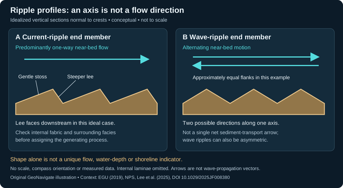
Sets of inclined internal layers within a bed, commonly produced as ripples or dunes migrate.
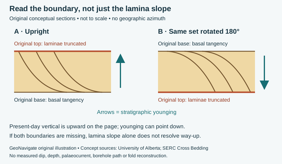
Interpretation note Terminology varies: dune-scale cross-stratification is commonly called cross-bedding and ripple-scale structures cross-lamination. Identify the set boundary that truncates older laminae before inferring stratigraphic way-up; internal lamina dip alone is insufficient.
Worked example: cross-bed truncation and way-up
Reference & related terms
Texas A&M Ocean Drilling Program — Sedimentary rock classificationReference reviewed 2026-10-28
Additional clarification reference
Related: Current ripple · Wave ripple · Younging direction · Overturned bedding · Lamination
Additional schematic: Cross-bed truncation and stratigraphic way-up
View schematic: Ripple profiles: current direction and oscillation axis
View in the Oilfield Glossary →
Geological time & dating# Cross-cutting relationship
The age relationship in which a geological feature is younger than the rock or structure it cuts.
Reference & related terms
Minnesota Geological Survey — Geologic TimeReference reviewed 2026-10-25
Related: Radiometric dating · Relative dating · Superposition
Structural geology & tectonics# Crust
Earth’s outermost compositional layer, encompassing distinct continental and oceanic types.
Reference & related terms
Karla Panchuk / BCcampus — Earth’s layersReference reviewed 2026-10-25
Related: Tectonic plate · Lithosphere · Asthenosphere · Mantle
Crystal form
A crystallographically defined arrangement of crystal faces; actual specimens may develop only some of those faces.
Reference & related terms
Utah Geological Survey — How do geologists identify minerals?Reference reviewed 2026-10-25
Wellsite geology & samples# Cuttings
Fragments generated as the bit breaks rock and carried to surface in the drilling fluid.
Reference & related terms
SLB Energy Glossary — CuttingsReference reviewed 2026-10-24
Related: Cavings · Lag time · Cuttings description · Sample provenance
View in the Oilfield Glossary →
Wellsite geology & samples# Cuttings description
Written observations of recovered rock fragments, including lithology, texture and shows, tied to a stated lag-corrected interval.
Reference & related terms
SLB — Defining Mud LoggingReference reviewed 2026-10-24
Related: Cuttings · Cavings · Lag time · Sample provenance
View in the Oilfield Glossary →
Wellsite geology & samples# Cuttings morphology
Observed size and shape of recovered drilled fragments. Bit action, transport and wall failure affect morphology, so shape alone is not a unique indicator of formation type.
Reference & related terms
SLB Energy Glossary — cuttingsReference reviewed 2026-10-24
View in the Oilfield Glossary →
Wellsite geology & samples# Cuttings sample interval
Measured-depth range assigned to a collected cuttings sample. It must be distinguished from collection time and from the bit depth when the material reached surface.
Reference & related terms
Energistics WITSML — CuttingsGeologyIntervalReference reviewed 2026-10-24
View in the Oilfield Glossary →
Wellsite geology & samples# Cuttings texture
Arrangement and appearance of grains, matrix and other fabric visible in recovered fragments. Drilling damage and small fragment size can limit how faithfully it represents the intact rock.
Reference & related terms
SLB Energy Glossary — cuttingsReference reviewed 2026-10-24
View in the Oilfield Glossary →
Igneous rocks & volcanology# Dacite
A silica-rich volcanic rock intermediate in composition between andesite and rhyolite.
Reference & related terms
USGS — Volcano Hazards Program GlossaryReference reviewed 2026-10-25
Hydrogeology & pore systems# Darcy flux
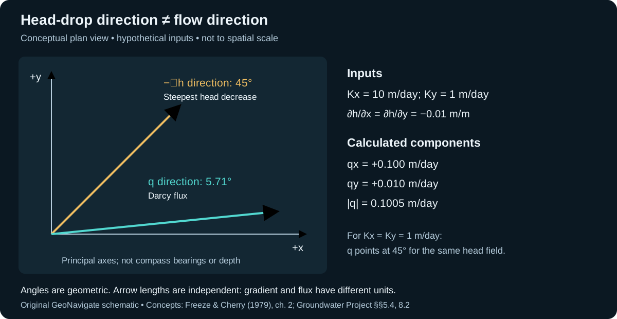
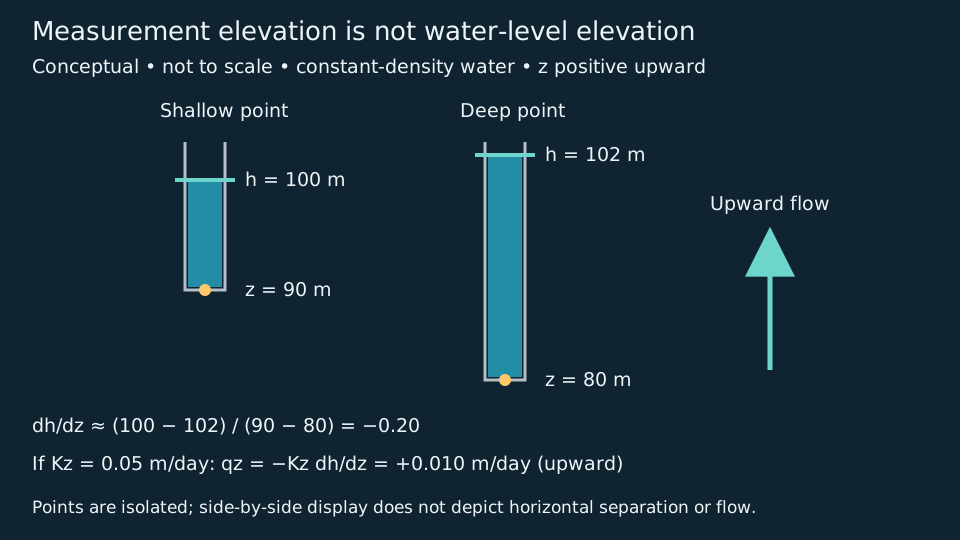
Volumetric discharge divided by the bulk cross-sectional area normal to flow: q = Q/A. For one-dimensional saturated Darcy flow, q = −K dh/dx. Its units are length per time, but it is not the velocity within connected pores.
Interpretation note Use the bulk area for q = Q/A; dividing by flow porosity gives an average advective speed, not a local pore-channel speed.
Worked example: flow porosity and travel-time sensitivity
Also called: Specific discharge, Darcy velocity
Reference & related terms
The Groundwater Project — groundwater flow principlesReference reviewed 2026-10-29
Related: Hydraulic head · Hydraulic gradient · Average linear groundwater velocity
View schematic: Groundwater head loss and Darcy flux
View in the Oilfield Glossary →
Geological time & dating# Daughter isotope
An isotope produced by radioactive decay of a parent isotope.
Interpretation note Measured daughter atoms can include both initial and radiogenic components. Treating all daughter atoms as decay products can bias an age.
Radiometric dating: half-life and age interpretation
Reference & related terms
Minnesota Geological Survey — Geologic TimeReference reviewed 2026-10-25
Additional clarification reference
Related: Half-life · Parent isotope · Radiometric dating · Radiogenic isotope · Closed isotopic system
View schematic: Radioactive decay in a closed teaching system
View in the Oilfield Glossary →
Geomorphology & glacial geology# Debris flow
A flowing mixture of water and sediment that contains substantial coarse particles and can travel rapidly downslope.
Reference & related terms
Virginia Tech — Introduction to Earth Science: Mass WastingReference reviewed 2026-10-25
Related: Earthflow
Deconvolution
Signal processing that estimates or removes a filtering effect to improve seismic wavelet shape or suppress predictable reverberations.
Reference & related terms
SLB Energy Glossary — deconvolutionReference reviewed 2026-10-24
View in the Oilfield Glossary →
Sedimentology & sedimentary rocks# Delta
Sedimentary accumulation where a sediment-bearing river enters standing water and loses transport capacity.
Reference & related terms
SLB Energy Glossary — deltaReference reviewed 2026-10-24
View in the Oilfield Glossary →
Geomorphology & glacial geology# Deposition
Accumulation of transported sediment when it is laid down.
Reference & related terms
British Geological Survey — Geological processesReference reviewed 2026-10-25
Related: Weathering · Erosion · Rock cycle
Sedimentology & sedimentary rocks# Depositional channel
Elongated depression that carries water and sediment and can become filled with a distinctive sediment body.
Reference & related terms
SLB Energy Glossary — channelReference reviewed 2026-10-24
View in the Oilfield Glossary →
Sedimentology & sedimentary rocks# Depositional environment
Physical, chemical and biological setting in which sediment accumulated; interpreted from multiple rock and fossil observations.
Also called: DE, Sedimentary environment
Reference & related terms
Texas A&M Ocean Drilling Program — Sedimentary rock classificationReference reviewed 2026-10-24
Related: Facies · Lithofacies · Stratigraphy · Sequence stratigraphy
View in the Oilfield Glossary →
Depth migration
Seismic imaging that places reflections in depth using a velocity model, particularly where velocity varies laterally.
Reference & related terms
SLB Energy Glossary — depth migrationReference reviewed 2026-10-24
View in the Oilfield Glossary →
Sedimentology & sedimentary rocks# Detrital
Describes rock or mineral particles derived from breakdown of pre-existing rocks and subsequently transported or deposited.
Also called: Clastic
Reference & related terms
SLB Energy Glossary — detritalReference reviewed 2026-10-24
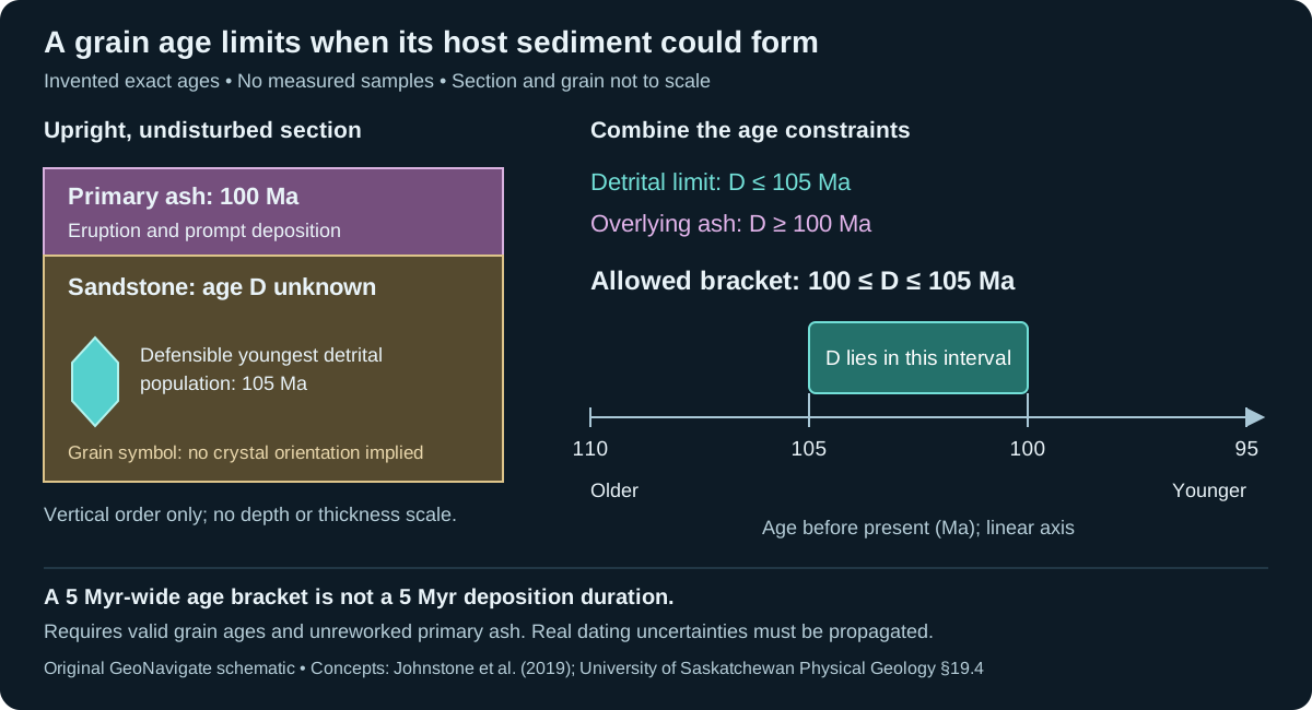
Related: Detrital zircon · Maximum depositional age
View schematic: A maximum depositional age is a bound
View in the Oilfield Glossary →
Sedimentology & sedimentary rocks# Diagenesis
Physical, chemical and biological changes to sediment after deposition, generally below metamorphic conditions. These changes can alter reservoir quality.
Reference & related terms
SLB Energy Glossary — DiagenesisReference reviewed 2026-10-24
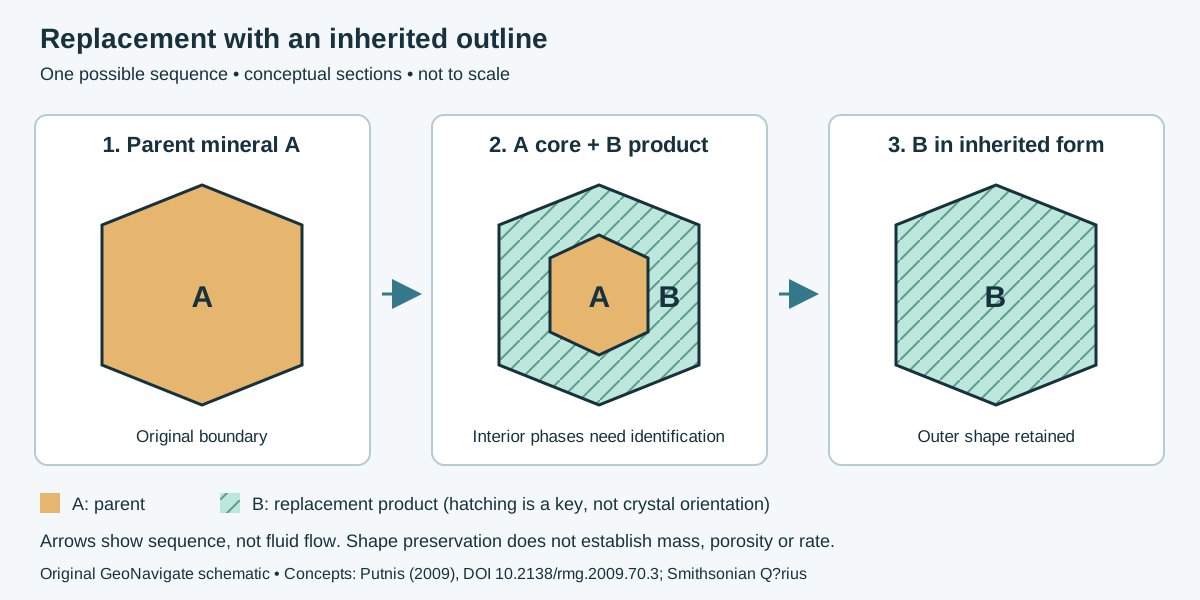
Related: Mineral replacement · Pseudomorph · Mechanical compaction · Pressure solution · Isotope delta · Isotope fractionation
View schematic: Replacement with an inherited outline
View in the Oilfield Glossary →
Geomorphology & glacial geology# Diamicton
An unconsolidated sediment with a very broad mixture of grain sizes; the name alone does not establish glacial origin.
Reference & related terms
Maine Geological Survey — Glossary of Terms Used on Surficial Geology MapsReference reviewed 2026-10-25
Structural geology & tectonics# Diapir
Mobile material, commonly salt or shale, that intrudes surrounding rock and can deform overlying beds.
Reference & related terms
SLB Energy Glossary — diapirReference reviewed 2026-10-24
View in the Oilfield Glossary →
Dim spot
Locally weakened seismic reflection amplitude, potentially caused by reduced impedance contrast associated with fluids or lithology.
Reference & related terms
SLB Energy Glossary — dim spotReference reviewed 2026-10-24
View in the Oilfield Glossary →
Igneous rocks & volcanology# Diorite
A coarse-grained intermediate intrusive rock commonly dominated by plagioclase with dark silicate minerals.
Reference & related terms
Steven Earle / BCcampus — Physical Geology: Classification of Igneous RockReference reviewed 2026-10-25
Related: Andesite
Structural geology & tectonics# Dip direction
Compass bearing of the steepest downward line in an inclined geological plane. It is perpendicular to strike and identifies which way the plane descends; it is an azimuth, not the dip angle.
Worked example: strike and apparent dip
Also called: Dip azimuth
Reference & related terms
University of Alberta — Orientation of structuresReference reviewed 2026-10-25
Related: Strike · Formation dip · Apparent dip · Right-hand rule
View schematic: Strike, dip direction and apparent dip
View in the Oilfield Glossary →
Stratigraphy & correlation# Disconformity
Break in the geological record between broadly parallel sedimentary beds, reflecting erosion or nondeposition.
Reference & related terms
SLB Energy Glossary — disconformityReference reviewed 2026-10-24
Related: Hiatus · Unconformity · Angular unconformity · Nonconformity · Conformable succession
View schematic: Unconformity geometries
View in the Oilfield Glossary →
Structural geology & tectonics# Divergent plate boundary
Boundary where plates move apart, commonly creating new oceanic lithosphere at a spreading centre.
Reference & related terms
Steven Earle / BCcampus — Plate motions and plate boundary processesReference reviewed 2026-10-25
Related: Convergent plate boundary · Transform plate boundary · Subduction · Continental rift
Dolomite mineral
Calcium-magnesium carbonate mineral, CaMg(CO₃)₂, that is the principal constituent of dolostone.
Also called: Dolomite
Reference & related terms
SLB Energy Glossary — Dolomite mineralReference reviewed 2026-10-24
Related: Calcite · Limestone · Dolostone · Marble
View in the Oilfield Glossary →
Sedimentology & sedimentary rocks# Dolomitization
Replacement of calcite by dolomite during diagenesis, potentially changing pore structure and reservoir properties.
Reference & related terms
SLB Energy Glossary — dolomitizationReference reviewed 2026-10-24
Related: Mineral replacement · Pseudomorph
View schematic: Replacement with an inherited outline
View in the Oilfield Glossary →
Sedimentology & sedimentary rocks# Dolostone
Carbonate rock composed mainly of dolomite mineral. The rock name distinguishes it from the mineral itself.
Also called: Dolomite rock
Reference & related terms
SLB Energy Glossary — DolostoneReference reviewed 2026-10-24
Related: Calcite · Dolomite mineral · Limestone · Marble · Karst · Sinkhole
View in the Oilfield Glossary →
Stratigraphy & correlation# Downlap
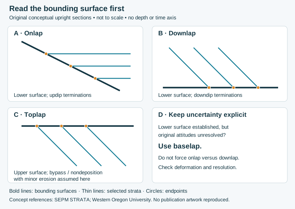
Termination of inclined strata against an underlying surface with a shallower apparent dip.
Interpretation note Read the termination relative to the lower bounding surface and original depositional geometry. In the standard usage, onlap ends updip and downlap ends downdip; present apparent dip alone may be misleading after deformation.
Worked interpretation: reflection terminations and uncertainty
Reference & related terms
SLB Energy Glossary — downlapReference reviewed 2026-10-24
Additional clarification reference
Related: Baselap · Toplap
View schematic: Reflection terminations: identify the bounding surface first
View in the Oilfield Glossary →
Wellsite geology & samples# Drilling-fluid contamination of samples
Presence of introduced fluid, additives or recirculated material in a geological sample. It can distort mineral, fluorescence, gas or chemical observations and should be documented.
Reference & related terms
SLB Oilfield Review — mud loggingReference reviewed 2026-10-24
View in the Oilfield Glossary →
Geomorphology & glacial geology# Drumlin
A streamlined hill shaped beneath moving ice, generally elongated parallel to former ice flow.
Reference & related terms
Maine Geological Survey — Glossary of Terms Used on Surficial Geology MapsReference reviewed 2026-10-25
Related: Glacier · Esker
Igneous rocks & volcanology# Dyke
A sheet-like igneous intrusion that cuts across the pre-existing structure of surrounding rocks.
Also called: Dike
Reference & related terms
Steven Earle / BCcampus — Physical Geology: Intrusive Igneous BodiesReference reviewed 2026-10-25
Related: Sill · Cross-cutting relationship
Geomorphology & glacial geology# Earthflow
A flow-like downslope movement dominated by fine-grained earth material, commonly involving abundant water.
Reference & related terms
Virginia Tech — Introduction to Earth Science: Mass WastingReference reviewed 2026-10-25
Hydrogeology & pore systems# Effective permeability
Permeability available to one fluid phase when other immiscible phases also occupy the rock.
Reference & related terms
SLB Energy Glossary — effective permeabilityReference reviewed 2026-10-24
View in the Oilfield Glossary →
Hydrogeology & pore systems# Effective porosity
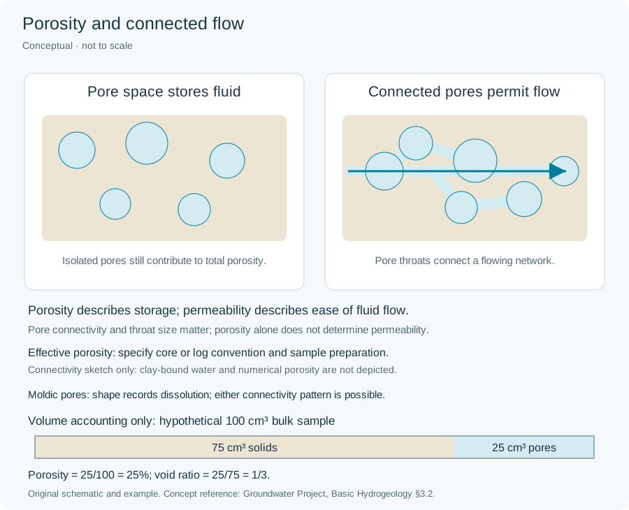
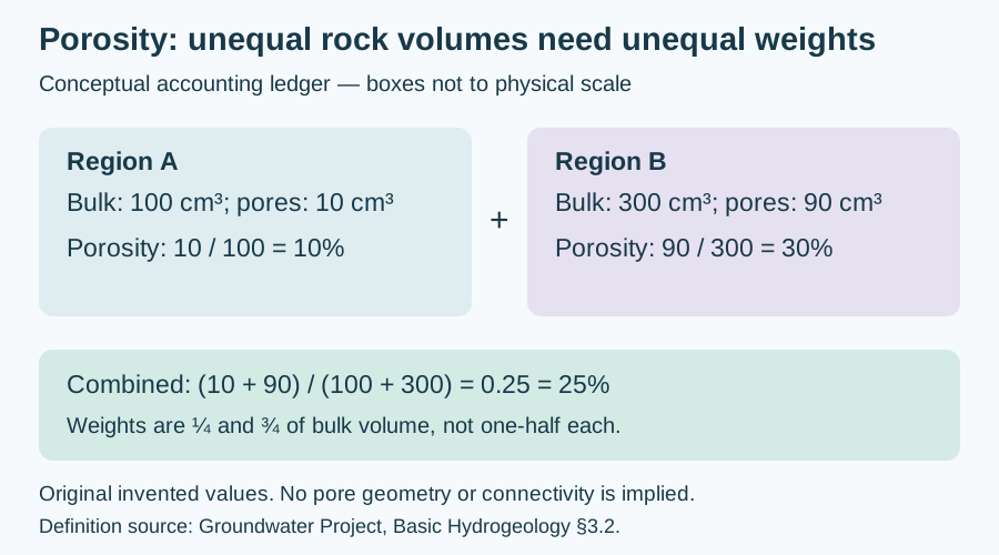
Interconnected pore fraction available for fluid flow; petrophysical conventions commonly exclude clay-bound water, so the interpretation basis should be stated.
Interpretation note State the measurement convention: dry-core connected porosity excludes isolated pores; a common log convention subtracts clay-bound water from total porosity. These are not interchangeable corrections. Retain sample preparation, method and bulk-volume basis with the result.
Worked example: porosity measurement conventions
Reference & related terms
SLB Energy Glossary — effective porosityReference reviewed 2026-10-29
Related: Porosity · Permeability · Fracture porosity · Secondary porosity · Sorption · Sorption distribution coefficient · Retardation factor · Total porosity
View schematic: Porosity and connected flow
View in the Oilfield Glossary →
Hydrogeology & pore systems# Effective stress
Stress acting on the solid framework of a porous material. For a saturated soil under the Terzaghi convention, effective normal stress equals total normal stress minus pore-water pressure; compression is positive.
Interpretation note When a falling water table reduces the weight of overlying sediment, total stress also changes. At a point that remains saturated, use Δσ′v = Δσv − Δu rather than treating the pressure decline alone as the effective-stress increase.
Worked example: falling water table and changing load
Also called: Intergranular stress
Reference & related terms
UWE GeotechniCAL — Stress in the groundReference reviewed 2026-10-25
Related: Pore-water pressure · Total vertical stress · Preconsolidation stress · Compaction
View schematic: Effective stress during pore-pressure decline
View in the Oilfield Glossary →
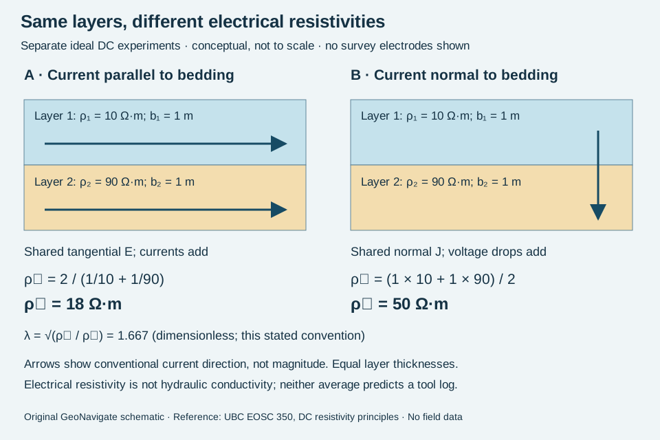
Hydrogeology & pore systems# Electrical anisotropy
Directional variation of electrical resistivity, commonly expressed as a difference between horizontal and vertical formation resistivity.
Interpretation note For continuous horizontal isotropic layers in ideal DC experiments, resistivity parallel to bedding is the thickness-weighted harmonic mean; normal resistivity is the thickness-weighted arithmetic mean. Name the axes and scale. These equivalent material values are not automatically apparent resistivities measured by a surface array or logging tool, and do not determine hydraulic conductivity.
Worked example: electrical versus hydraulic anisotropy
Reference & related terms
SLB Energy Glossary — electrical anisotropyReference reviewed 2026-10-24
Additional clarification reference
Related: Anisotropy · Layered heterogeneity
View schematic: Electrical resistivity along and across layers
View in the Oilfield Glossary →
Geomorphology & glacial geology# End moraine
A ridge of sediment accumulated at a former glacier margin.
Reference & related terms
Maine Geological Survey — Glossary of Terms Used on Surficial Geology MapsReference reviewed 2026-10-25
Sedimentology & sedimentary rocks# Eolian
Describes sediment transport and deposition by wind.
Also called: Aeolian
Reference & related terms
SLB Energy Glossary — eolianReference reviewed 2026-10-24
View in the Oilfield Glossary →
Geomorphology & glacial geology# Erosion
Removal and transport of rock or sediment by agents such as water, wind, ice or gravity.
Reference & related terms
British Geological Survey — Geological processesReference reviewed 2026-10-25
Related: Weathering · Deposition · Rock cycle
Geomorphology & glacial geology# Esker
A winding ridge of sand and gravel deposited by glacial meltwater, commonly in channels within or beneath ice.
Reference & related terms
Maine Geological Survey — Glossary of Terms Used on Surficial Geology MapsReference reviewed 2026-10-25
Related: Outwash
Sedimentology & sedimentary rocks# Estuary
Partly enclosed coastal setting where river water mixes with seawater.
Reference & related terms
SLB Energy Glossary — estuaryReference reviewed 2026-10-24
View in the Oilfield Glossary →
Sedimentology & sedimentary rocks# Evaporite
Mineral deposit or rock produced by precipitation as saline water concentrates, commonly containing halite, gypsum or anhydrite.
Reference & related terms
SLB Energy Glossary — EvaporiteReference reviewed 2026-10-24
View in the Oilfield Glossary →
Igneous rocks & volcanology# Extrusive rock
Igneous rock produced by volcanic material at the surface, often fine-grained, glassy or fragmental.
Also called: Volcanic rock
Reference & related terms
Virginia Tech — Introduction to Earth Science: Igneous Processes and VolcanoesReference reviewed 2026-10-25
Related: Basalt · Rhyolite · Igneous rock · Magma · Lava · Intrusive rock
Sedimentology & sedimentary rocks# Facies
A rock body or sediment distinguished by a characteristic combination of composition, texture, structures or fossils.
Reference & related terms
SLB Energy Glossary — FaciesReference reviewed 2026-10-24
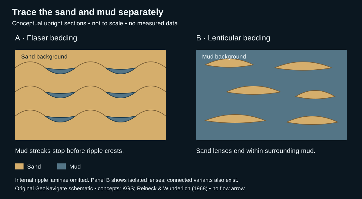
Related: Lithofacies · Depositional environment · Stratigraphy · Sequence stratigraphy · Flaser bedding · Lenticular bedding · Walther’s law · Facies association
View schematic: Flaser and lenticular bedding: trace the contrasting material
View in the Oilfield Glossary →
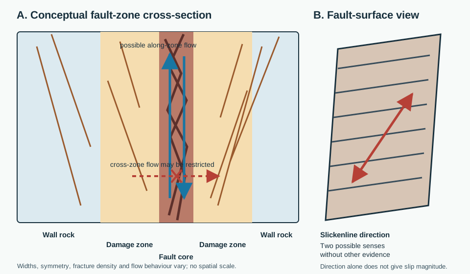
Structural geology & tectonics# Fault
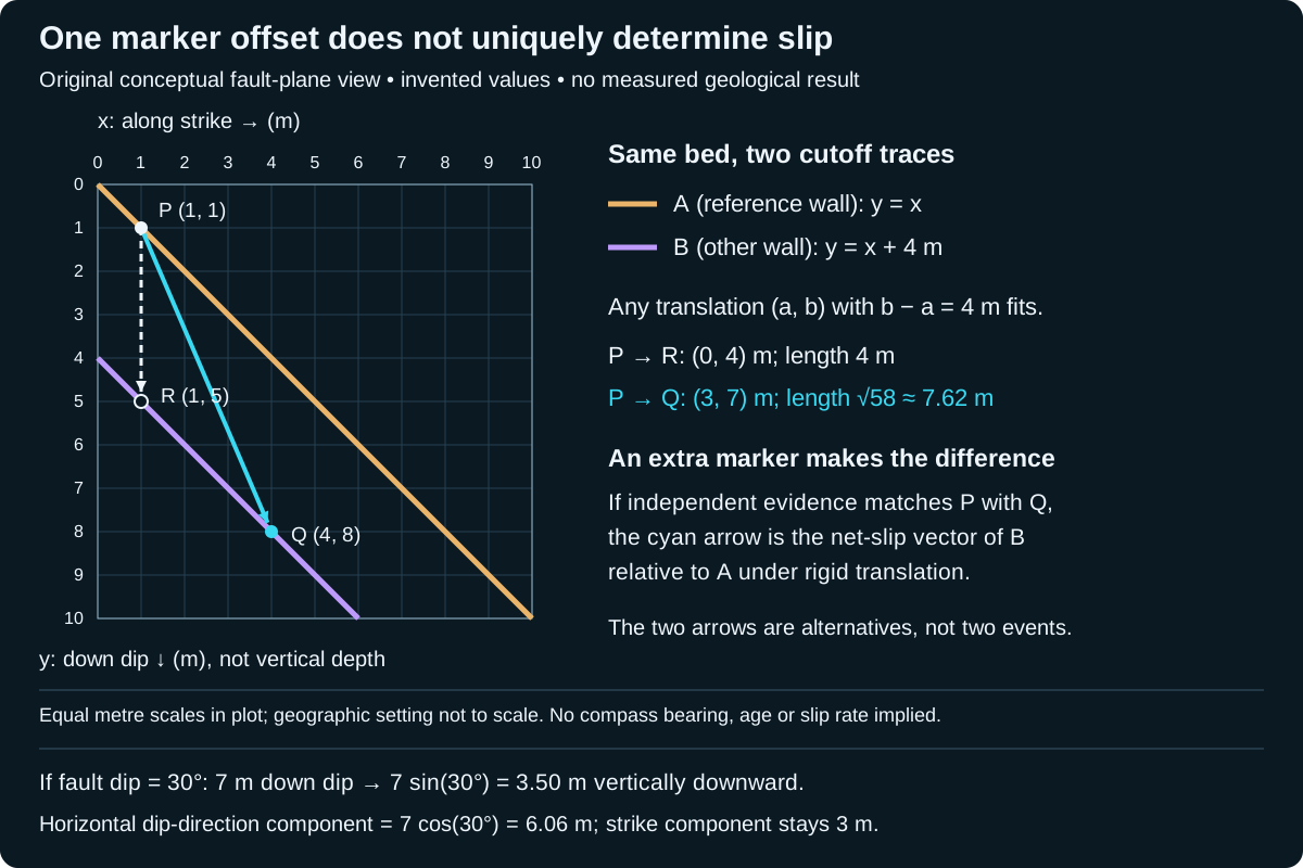
Fracture or fracture zone across which rock bodies have moved relative to one another.
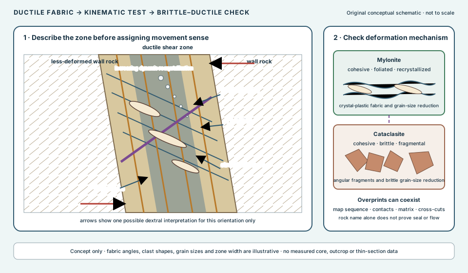
Field guide: fault core, damage zone and slickenlines
Reference & related terms
SLB Energy Glossary — FaultReference reviewed 2026-10-24
Related: Hanging wall · Footwall · Normal fault · Reverse fault · Thrust fault · Fault core · Fault damage zone · Slickenline · Ductile shear zone · Mylonite · Fault separation · Net slip · Piercing point
View schematic: Fault-zone architecture and slip-direction evidence
View in the Oilfield Glossary →
Fayalite
The iron end member of the olivine solid-solution series, with composition Fe2SiO4.
Reference & related terms
Virginia Tech — Introduction to Earth Science: MineralsReference reviewed 2026-10-25
Related: Olivine · Forsterite
Feldspar
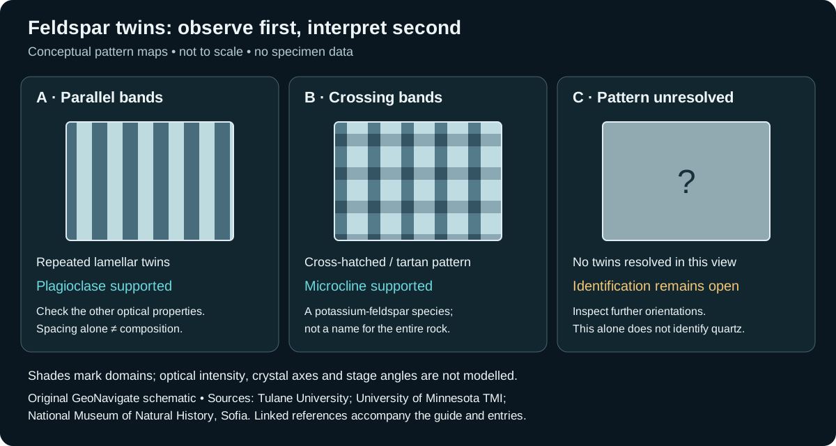
Group of common silicate minerals present in many sandstones and crystalline rocks; alteration can produce clay minerals.
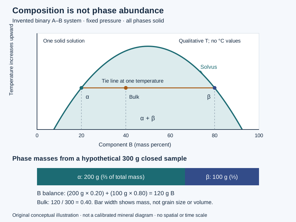
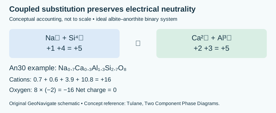
Interpretation note In ideal plagioclase, replacing Na+ with Ca2+ is balanced by replacing Si4+ with Al3+: both paired contributions total +5. An30 denotes 30 mole percent anorthite component, not 30 percent calcium by mass.
Worked example: plagioclase charge balance
Reference & related terms
SLB Energy Glossary — feldsparReference reviewed 2026-10-24
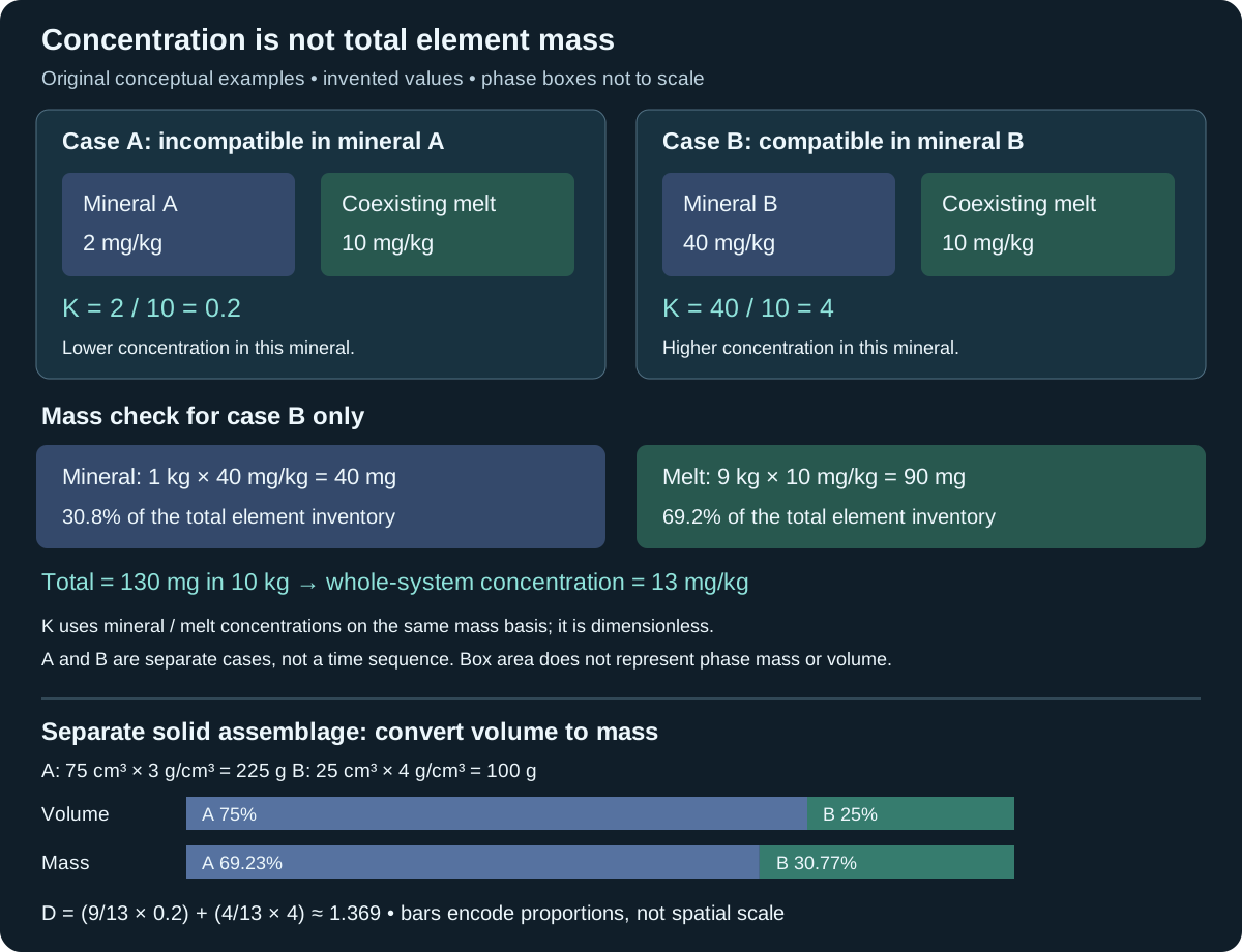
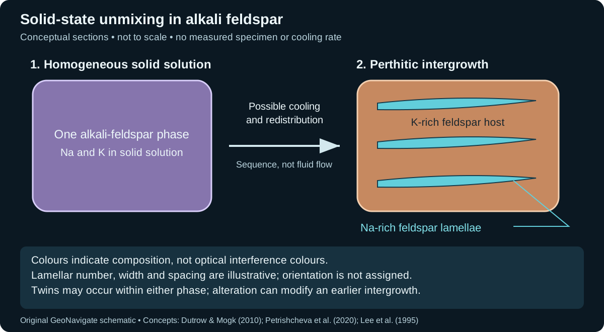
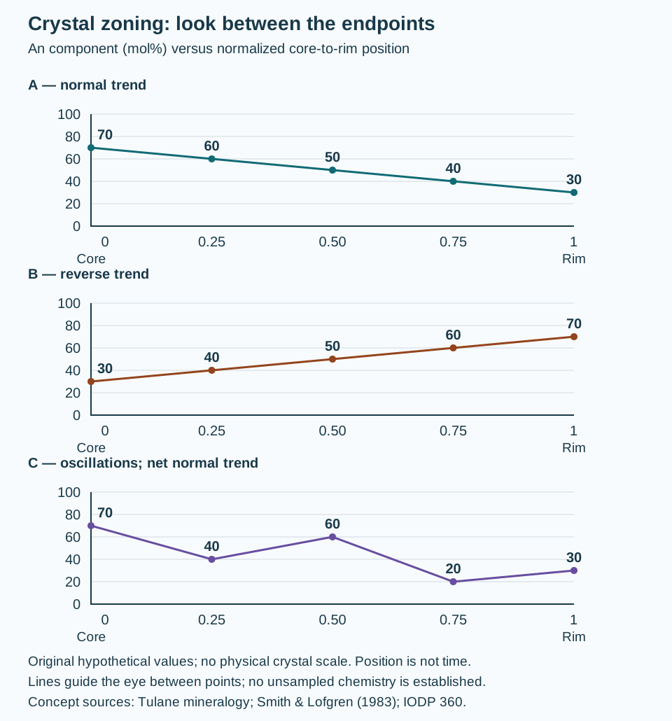
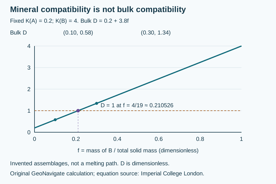
Related: Plagioclase · Potassium feldspar · Granite · Crystal twinning · Polysynthetic twinning · Microcline · Mineral–melt partition coefficient · Compatible element · Incompatible element · Mineral exsolution · Perthite
Additional schematic: Plagioclase coupled substitution
View schematic: Feldspar twin patterns and an unresolved grain
View in the Oilfield Glossary →
Igneous rocks & volcanology# Felsic
Describing silica-rich igneous compositions typically dominated by feldspar and quartz, with comparatively few iron–magnesium minerals.
Reference & related terms
Steven Earle / BCcampus — Physical Geology: Classification of Igneous RockReference reviewed 2026-10-25
Sedimentology & sedimentary rocks# Fence diagram
Perspective display of intersecting geological cross sections used to show three-dimensional relationships among rock units.
Reference & related terms
SLB Energy Glossary — fence diagramReference reviewed 2026-10-24
View in the Oilfield Glossary →
Geomorphology & glacial geology# Firn
Compacted granular snow surviving beyond a melt season and progressing toward glacier ice through further densification.
Also called: Névé, Neve
Reference & related terms
Virginia Tech — Introduction to Earth Science: GlaciersReference reviewed 2026-10-25
Sedimentology & sedimentary rocks# Floatstone
Coarse carbonate rock supported by matrix, with more than 10% grains larger than 2 mm.
Reference & related terms
IODP Expedition 359 — sediment and rock classificationReference reviewed 2026-10-25
Related: Rudstone · Boundstone · Bafflestone · Bindstone · Framestone
View schematic: Carbonate depositional textures
Wellsite geology & samples# Flowline sample
Sample of returning drilling fluid collected before solids removal, potentially containing drilled cuttings. Record its collection point because screening changes the solids represented.
Reference & related terms
SLB Energy Glossary — flowline mud sampleReference reviewed 2026-10-24
View in the Oilfield Glossary →
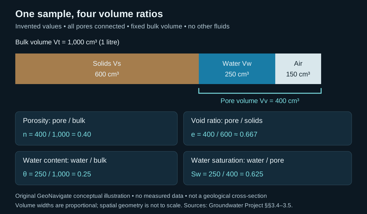
Petroleum geology & geochemistry# Fluid saturation
Fraction of a defined pore volume occupied by a particular fluid.
Reference & related terms
SLB — Reservoir engineeringReference reviewed 2026-10-24
Related: Void ratio · Volumetric water content
View schematic: One sample, four different volume ratios
View in the Oilfield Glossary →
Wellsite geology & samples# Fluorescence
Visible light emitted under ultraviolet illumination; hydrocarbon interpretation must consider mineral and drilling-fluid fluorescence.
Reference & related terms
SLB — Defining Mud LoggingReference reviewed 2026-10-24
View in the Oilfield Glossary →
Sedimentology & sedimentary rocks# Fluvial
Describes sediment transport, deposition or landforms associated with rivers and streams.
Reference & related terms
SLB Energy Glossary — fluvialReference reviewed 2026-10-24
View in the Oilfield Glossary →
Structural geology & tectonics# Fold
Bend in originally straighter rock layers produced by deformation.
Worked folding geometry and slip evidence
Reference & related terms
SLB Energy Glossary — foldReference reviewed 2026-10-24
Related: Fold axial plane · Fold hinge · Fold limb · Anticline · Syncline · Antiform · Flexural slip · Flexural flow
View schematic: Folding: localized slip, distributed shear and arc lengths
View in the Oilfield Glossary →
Structural geology & tectonics# Fold axial plane
Plane connecting the hinge lines of successive folded layers.
Also called: Axial plane
Reference & related terms
BGS / JNCC — Geological Conservation Review 34 glossaryReference reviewed 2026-10-25
Related: Fold · Fold hinge · Fold limb · Anticline · Syncline · Antiform
Structural geology & tectonics# Fold hinge
Line of strongest curvature along a folded surface.
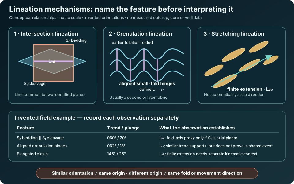
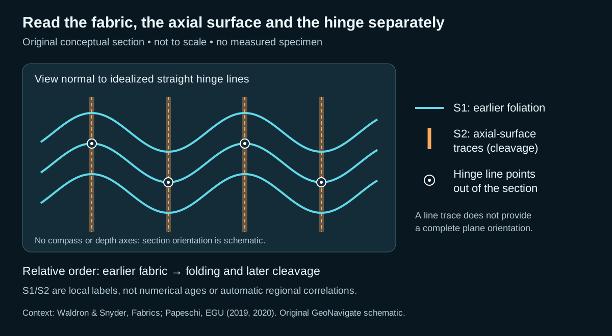
Interpretation note A hinge line, an intersection lineation and a stretching lineation are not interchangeable. Compare orientations and fabric relationships before using any lineation as a fold-axis proxy.
Worked example: separate lineation mechanisms
Also called: Hinge line
Reference & related terms
BGS / JNCC — Geological Conservation Review 34 glossaryReference reviewed 2026-10-25
Related: Fold · Fold axial plane · Fold limb · Anticline · Syncline · Antiform · Lineation · Intersection lineation · Crenulation lineation · Stretching lineation
View schematic: Lineation mechanisms and interpretation checks
Structural geology & tectonics# Fold limb
Part of a fold between neighbouring hinge zones.
Interpretation note Determine stratigraphic way-up separately from present vertical: a normal graded bed fines toward its original top even after overturning. Confirm the depositional interpretation with other indicators before assigning younging.
Worked example: which way is stratigraphic up?
Reference & related terms
BGS / JNCC — Geological Conservation Review 34 glossaryReference reviewed 2026-10-25
Related: Fold · Fold axial plane · Fold hinge · Anticline · Syncline · Antiform · Younging direction · Overturned bedding
View schematic: Present vertical and stratigraphic younging
Metamorphism & metamorphic rocks# Foliation
A penetrative planar fabric in rock, commonly produced by aligned minerals or compositional segregation during deformation and metamorphism.
Interpretation note Foliation is planar; lineation is linear. A lineation may lie within a foliation, arise from two intersecting foliations, or record a separate fabric element.
Worked example: separate lineation mechanisms
Reference & related terms
Virginia Tech — Introduction to Earth Science: Metamorphic RocksReference reviewed 2026-10-25
Related: Schistosity · Gneiss · Lineation · Intersection lineation · Crenulation lineation · Stretching lineation
View schematic: Lineation mechanisms and interpretation checks
Stratigraphy & correlation# Formation
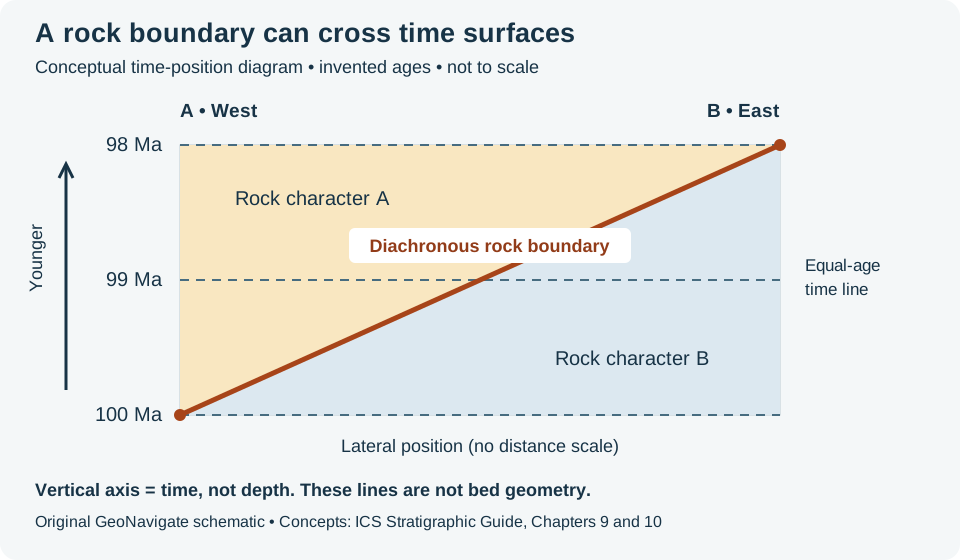
Primary lithostratigraphic unit: a distinguishable, mappable body of rock defined by lithological characteristics.
Interpretation note A lithological boundary is not automatically a time surface. Track the rock pick and its age interpretation separately.
Worked example: rock boundary versus time surface
Reference & related terms
International Commission on Stratigraphy — Lithostratigraphic unitsReference reviewed 2026-10-25
Additional clarification reference
Related: Member · Bed · Group · Supergroup · Lithostratigraphy · Lithostratigraphic unit · Diachronous · Isochronous
View schematic: A rock boundary can cross time surfaces
View in the Oilfield Glossary →
Structural geology & tectonics# Formation dip
Inclination of a geological surface from horizontal, specified together with the direction of maximum downward slope.
Interpretation note True dip is the maximum inclination below horizontal. It is measured perpendicular to strike; an oblique section generally shows a smaller angle.
Worked example: strike and apparent dip
Also called: Dip, True dip
Reference & related terms
SLB Energy Glossary — Formation dipReference reviewed 2026-10-25
Additional clarification reference
Related: Strike · Apparent dip · True stratigraphic thickness · True vertical thickness · Dip direction · Right-hand rule
View schematic: Strike, dip direction and apparent dip
View in the Oilfield Glossary →
Forsterite
The magnesium end member of the olivine solid-solution series, with composition Mg2SiO4.
Reference & related terms
Virginia Tech — Introduction to Earth Science: MineralsReference reviewed 2026-10-25
Related: Olivine · Fayalite
Forward modelling
Calculation of the measurements a sensor should produce for a specified subsurface model, tool configuration and environment.
Also called: Forward modeling
Reference & related terms
SLB Energy Glossary — forward modelingReference reviewed 2026-10-24
Related: Geophysical inversion · Model nonuniqueness · Model-data misfit
View in the Oilfield Glossary →
Fossil
Preserved remains or evidence of past organisms, such as shells, casts, tracks or burrows.
Interpretation note Record preservation and host sediment separately; an older fossil can be redeposited into a younger bed.
Fossil preservation and reworking: worked interpretation
Reference & related terms
SLB Energy Glossary — fossilReference reviewed 2026-10-24
Related: Body fossil · Trace fossil · Taphonomy · Fossil mould · Reworked fossil · Fossil disarticulation
View schematic: Fossil reworking: two burial histories
View in the Oilfield Glossary →
Fossil cast
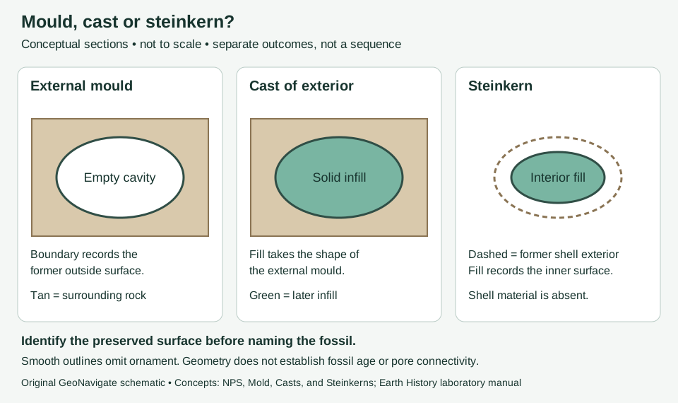
A positive replica formed when sediment or minerals fill a fossil mould.
Interpretation note A cast is infill, not surviving shell material. Record the fill and surrounding rock separately; do not equate a filled fossil shape with an open pore.
Worked example: describe a mould, cast or steinkern
Reference & related terms
National Park Service — Mold, Casts, and SteinkernsReference reviewed 2026-10-29
Related: Fossil mould · Steinkern
View schematic: Mould, cast or steinkern: which surface survives?
View in the Oilfield Glossary →
Fossil disarticulation
Separation of once-connected skeletal elements, such as bones or shell valves. It describes preservation and does not by itself establish transport distance.
Fossil preservation and reworking: worked interpretation
Also called: Disarticulated remains
Reference & related terms
National Park Service — TaphonomyReference reviewed 2026-10-25
Related: Fossil · Biostratigraphy · Taphonomy · Body fossil · Fossil time averaging · Death assemblage
View in the Oilfield Glossary →
Fossil mould
A three-dimensional impression preserving an organism's shape after original material has disappeared.
Interpretation note Specify the surface represented: an external mould records the outside of a shell. In a broken cutting, record the visible impression before inferring a complete organism.
Worked example: describe a mould, cast or steinkern
Also called: Fossil mold
Reference & related terms
National Park Service — Mold, Casts, and SteinkernsReference reviewed 2026-10-29
Related: Fossil cast · Steinkern · Fossil · Body fossil · Trace fossil · Taphonomy
View schematic: Mould, cast or steinkern: which surface survives?
View in the Oilfield Glossary →
Fossil replacement
Substitution of new minerals for original biological material as that material dissolves.
Also called: Replacement fossilization
Reference & related terms
National Park Service — Permineralization and ReplacementReference reviewed 2026-10-25
Hydrogeology & pore systems# Fracture porosity
Pore volume contained in natural fractures; even small fracture volumes can strongly affect permeability.
Reference & related terms
SLB Energy Glossary — fracture porosityReference reviewed 2026-10-24
Related: Porosity · Permeability · Effective porosity · Secondary porosity
View schematic: Porosity and connected flow
View in the Oilfield Glossary →
Sedimentology & sedimentary rocks# Framestone
Boundstone supported by a rigid framework built by organisms.
Reference & related terms
IODP Expedition 359 — sediment and rock classificationReference reviewed 2026-10-25
Related: Rudstone · Floatstone · Boundstone · Bafflestone · Bindstone
Igneous rocks & volcanology# Gabbro
A coarse-grained mafic intrusive rock principally containing plagioclase and pyroxene, sometimes with olivine.
Reference & related terms
Steven Earle / BCcampus — Physical Geology: Classification of Igneous RockReference reviewed 2026-10-25
Related: Basalt · Mafic · Ophitic texture
Wellsite geology & samples# Gas chromatography GC
Separation and measurement of individual gas components, allowing composition to be evaluated alongside total-gas readings.
Reference & related terms
SLB — Defining Mud LoggingReference reviewed 2026-10-24
View in the Oilfield Glossary →
Wellsite geology & samples# Gas component ratio
Ratio calculated from measured gas components, commonly used to compare changes in gas character. Sampling, detector response and drilling-fluid contamination can affect its interpretation.
Reference & related terms
SLB Oilfield Review — mud loggingReference reviewed 2026-10-24
View in the Oilfield Glossary →
Wellsite geology & samples# Gas show
Increase in detected mud gas relative to the surrounding trend, evaluated at lagged depth and against drilling conditions.
Reference & related terms
SLB Energy Glossary — Gas showReference reviewed 2026-10-24
View in the Oilfield Glossary →
Sedimentology & sedimentary rocks# Geological cement
Minerals precipitated within pore spaces that bind sediment grains; distinct from engineered cement placed during well construction.
Also called: Mineral cement, Rock cement
Reference & related terms
SLB Energy Glossary — Geological cementReference reviewed 2026-10-24
Related: Grain roundness · Sorting · Grain size · Matrix
View in the Oilfield Glossary →
Structural geology & tectonics# Geological cross section
Vertical view through the subsurface showing interpreted rock units, faults and other structures.
Also called: Cross section
Reference & related terms
SLB Energy Glossary — cross sectionReference reviewed 2026-10-24
View in the Oilfield Glossary →
Geophysical inversion
Mathematical estimation of a subsurface model consistent with measured data and stated assumptions; a fit does not guarantee a unique solution.
Also called: Inversion, Inverse problem
Reference & related terms
SLB Energy Glossary — inversionReference reviewed 2026-10-24
Related: Forward modelling · Model nonuniqueness · Model-data misfit
View in the Oilfield Glossary →
Geostatistics
Statistical methods that account for spatial relationships when estimating or simulating subsurface properties from incomplete sampling.
Reference & related terms
SLB Energy Glossary — geostatisticsReference reviewed 2026-10-24
View in the Oilfield Glossary →
Geomorphology & glacial geology# Glacial horn
A sharp mountain peak formed where several cirques erode toward one another.
Also called: Horn (glacial)
Reference & related terms
Virginia Tech — Introduction to Earth Science: GlaciersReference reviewed 2026-10-25
Geomorphology & glacial geology# Glacier
A persistent mass of land ice that moves under its own weight.
Reference & related terms
Virginia Tech — Introduction to Earth Science: GlaciersReference reviewed 2026-10-25
Related: Firn · Cirque
Geomorphology & glacial geology# Glaciolacustrine
Relating to deposition or processes in lakes influenced by glacial meltwater.
Reference & related terms
Maine Geological Survey — Glossary of Terms Used on Surficial Geology MapsReference reviewed 2026-10-25
Geomorphology & glacial geology# Glaciomarine
Relating to marine sedimentation or processes influenced directly by glaciers or floating glacial ice.
Reference & related terms
Maine Geological Survey — Glossary of Terms Used on Surficial Geology MapsReference reviewed 2026-10-25
Glauconite
Green, iron-bearing silicate mineral commonly associated with slowly accumulating marine sediments.
Reference & related terms
SLB Energy Glossary — glauconiteReference reviewed 2026-10-24
View in the Oilfield Glossary →
Metamorphism & metamorphic rocks# Gneiss
A metamorphic rock characterized by compositional banding, commonly separating lighter and darker mineral-rich domains.
Reference & related terms
Steven Earle / BCcampus — Physical Geology: Classification of Metamorphic RocksReference reviewed 2026-10-25
Related: Migmatite · Foliation
Structural geology & tectonics# Graben
Relatively lowered rock block bounded by normal faults dipping toward the block.
Reference & related terms
SLB Energy Glossary — grabenReference reviewed 2026-10-24
View in the Oilfield Glossary →
Sedimentology & sedimentary rocks# Grain roundness
Degree to which a grain’s corners and edges are smoothed; distinct from its overall shape or sphericity.
Interpretation note Assess edge and corner curvature separately from overall grain proportions. A two-dimensional view can obscure three-dimensional form; breakage during drilling and preparation may introduce fresh angular surfaces.
Grain size and texture: worked examples
Also called: Roundness
Reference & related terms
Geological Survey of India — Sedimentary rock texturesReference reviewed 2026-10-24
Additional clarification reference
Related: Sorting · Grain size · Matrix · Geological cement · Phi scale · Grain sphericity
View schematic: Grain size, sorting and grain shape
View in the Oilfield Glossary →
Sedimentology & sedimentary rocks# Grain size
Dimensions of sediment particles, described using a stated size scale; size classes should not be inferred solely from rock colour.
Interpretation note State the size scale and measurement method. A sieve aperture, microscope section and laser-derived equivalent diameter need not give identical distributions. Phi increases as diameter decreases.
Grain size and texture: worked examples
Reference & related terms
Geological Survey of India — Sedimentary rock texturesReference reviewed 2026-10-24
Additional clarification reference
Related: Sand · Silt · Clay-size sediment · Gravel · Udden-Wentworth scale · Grain roundness · Phi scale · Grain sphericity · Median grain size · Sieve analysis
View schematic: Wentworth grain-size classes
View in the Oilfield Glossary →
Sedimentology & sedimentary rocks# Grain sphericity
Degree to which the three-dimensional form of a particle approaches a sphere. Sphericity concerns overall proportions, whereas roundness concerns smoothing of corners and edges; a rounded elongated grain can have low sphericity.
Interpretation note A circular silhouette in one view does not establish a spherical three-dimensional grain. Record orthogonal dimensions or additional views; keep any axis ratio distinct from a named sphericity index and from corner roundness.
Worked example: a circular view can hide flattening
Also called: Sphericity
Reference & related terms
Open University — sediment textureReference reviewed 2026-10-31
Related: Grain size · Sorting · Grain roundness
View schematic: A circular view can hide a flattened grain
View in the Oilfield Glossary →
Sedimentology & sedimentary rocks# Grainstone
Grain-supported carbonate rock lacking depositional lime mud; pore space may later contain cement.
Reference & related terms
IODP Expedition 359 — sediment and rock classificationReference reviewed 2026-10-25
Related: Mudstone · Carbonate mudstone · Wackestone · Packstone · Boundstone
View schematic: Carbonate depositional textures
Igneous rocks & volcanology# Granite
A coarse-grained felsic intrusive rock containing quartz and feldspars, commonly with mica or amphibole.
Reference & related terms
Steven Earle / BCcampus — Physical Geology: Classification of Igneous RockReference reviewed 2026-10-25
Related: Rhyolite · Felsic · Feldspar · Plagioclase · Potassium feldspar
Sedimentology & sedimentary rocks# Granule
Gravel particle in the 2–4 mm Wentworth size class.
Reference & related terms
USGS Bulletin 1046-Q — Wentworth grain-size classification, table 1Reference reviewed 2026-10-25
Related: Pebble · Cobble · Boulder · Gravel
View schematic: Wentworth grain-size classes
Sedimentology & sedimentary rocks# Gravel
Sediment coarser than 2 mm, including granules, pebbles, cobbles and boulders.
Reference & related terms
USGS Bulletin 1046-Q — Wentworth grain-size classification, table 1Reference reviewed 2026-10-25
Related: Sand · Silt · Clay-size sediment · Grain size · Udden-Wentworth scale · Granule
View schematic: Wentworth grain-size classes
Igneous rocks & volcanology# Groundmass
The finer-grained or glassy material surrounding larger crystals in an igneous rock.
Reference & related terms
Virginia Tech — Introduction to Earth Science: Igneous Processes and VolcanoesReference reviewed 2026-10-25
Related: Phenocryst
Hydrogeology & pore systems# Groundwater
Water occupying connected pores and fractures below the ground in the saturated zone.
Reference & related terms
USGS Water Science School — Water Science GlossaryReference reviewed 2026-10-25
Related: Aquifer · Water table · Unconfined aquifer · Confined aquifer · Artesian condition · Groundwater recharge · Isotropy · Hydraulic conductivity tensor
View schematic: Head-drop direction and Darcy flux
Hydrogeology & pore systems# Groundwater drawdown
Decrease in groundwater level or hydraulic head caused by pumping.
Worked hydraulic response and head interpretation
Also called: Aquifer drawdown
Reference & related terms
USGS Water Science School — Water Science GlossaryReference reviewed 2026-10-25
Related: Hydraulic conductivity · Transmissivity · Specific yield · Specific retention · Potentiometric surface · Hydraulic diffusivity
View schematic: Confined head response and hydraulic diffusivity
Hydrogeology & pore systems# Groundwater recharge
Addition of water to an aquifer, including infiltrated precipitation that reaches the saturated zone.
Also called: Recharge
Reference & related terms
USGS Water Science School — Water Science GlossaryReference reviewed 2026-10-25
Related: Infiltration · Groundwater · Water table · Spring
Stratigraphy & correlation# Group
Formal lithostratigraphic unit containing two or more formations with shared lithological characteristics.
Reference & related terms
International Commission on Stratigraphy — Lithostratigraphic unitsReference reviewed 2026-10-25
Related: Formation · Member · Bed · Supergroup · Lithostratigraphy · Lithostratigraphic unit
Structural geology & tectonics# Growth fault
Fault active during sediment deposition, commonly producing a thicker sedimentary section on its downthrown side.
Reference & related terms
SLB Energy Glossary — growth faultReference reviewed 2026-10-24
View in the Oilfield Glossary →
Gypsum
Hydrated calcium-sulfate evaporite mineral that can convert to anhydrite through dehydration.
Reference & related terms
SLB Energy Glossary — gypsumReference reviewed 2026-10-24
View in the Oilfield Glossary →
Geological time & dating# Half-life
The time required for half the atoms of a radioactive isotope to decay.
Interpretation note Each equal half-life removes half of the remaining parent population, not half of the original population. After three half-lives, one eighth remains. With 75% of the original parent remaining in a closed system, elapsed time is log₂(1/0.75) ≈ 0.415 half-lives; linear interpolation between 100% and 50% gives the wrong time.
Worked example: a fraction of a half-life
Reference & related terms
Minnesota Geological Survey — Geologic TimeReference reviewed 2026-10-30
Additional clarification reference
Related: Parent isotope · Daughter isotope · Radiometric dating · Radiogenic isotope · Closed isotopic system
View schematic: Radioactive decay in a closed teaching system
View in the Oilfield Glossary →
Halide mineral
A mineral built from halogen anions and cations; halite and sylvite are common examples.
Reference & related terms
Virginia Tech — Introduction to Earth Science: MineralsReference reviewed 2026-10-25
Halite
Sodium-chloride evaporite mineral, also called rock salt, capable of flowing into diapirs and forming effective seals.
Reference & related terms
SLB Energy Glossary — haliteReference reviewed 2026-10-24
View in the Oilfield Glossary →
Geomorphology & glacial geology# Hanging valley
A tributary valley left above the floor of a more deeply eroded main glacial valley.
Reference & related terms
Virginia Tech — Introduction to Earth Science: GlaciersReference reviewed 2026-10-25
Structural geology & tectonics# Hanging wall
Rock block above an inclined fault surface.
Also called: Hangingwall
Reference & related terms
BGS / JNCC — Geological Conservation Review 34 glossaryReference reviewed 2026-10-25
Related: Footwall · Fault · Normal fault · Reverse fault · Thrust fault
Heterogeneity
Variation of rock properties from one location to another within a formation or reservoir.
Interpretation note Heterogeneity describes changes between locations; anisotropy describes changes with direction. A layered unit can have both, depending on the observation scale.
Worked example: conductivity along and across layers
Reference & related terms
SLB Energy Glossary — heterogeneityReference reviewed 2026-10-24
Related: Layered heterogeneity · Equivalent hydraulic conductivity
View schematic: Layer-parallel and layer-normal groundwater flow
View in the Oilfield Glossary →
Stratigraphy & correlation# Hiatus
Interval of geological time missing from a sedimentary record because deposition stopped or material was eroded.
Interpretation note A preserved-thickness/time average spanning a hiatus includes the gap in its denominator. Recovering a rate for depositional intervals alone requires independent constraints on their duration and on erosion and compaction.
Worked example: hiatus and accumulation-rate denominators
Reference & related terms
SLB Energy Glossary — hiatusReference reviewed 2026-10-25
Related: Unconformity · Disconformity · Angular unconformity · Nonconformity · Conformable succession · Synthem · Barren interval
Additional schematic: Hiatus and average accumulation rate
View schematic: Unconformity geometries
Structural geology & tectonics# Horst
Relatively elevated rock block between normal faults that dip outward from it.
Reference & related terms
SLB Energy Glossary — horstReference reviewed 2026-10-24
View in the Oilfield Glossary →
Hydrogeology & pore systems# Hydraulic conductivity
Capacity of a porous material to transmit a particular fluid under a hydraulic gradient; depends on both material and fluid properties. K depends on the medium and fluid: K = kρg/μ, where k is intrinsic permeability, ρ density and μ dynamic viscosity. Temperature can change K without changing pore geometry.
Interpretation note Conductivity has velocity units but is not pore-water travel speed. For fixed pore geometry and density, doubling dynamic viscosity halves K. State the fluid, temperature and test direction; the worked example uses a scalar conductivity.
Worked example: permeability versus hydraulic conductivity
Reference & related terms
USGS — Ground-Water Hydrology of the Upper Klamath Basin, hydraulic propertiesReference reviewed 2026-10-25
Additional clarification reference
Related: Transmissivity · Specific yield · Specific retention · Groundwater drawdown · Permeability · Absolute permeability · Layered heterogeneity · Equivalent hydraulic conductivity · Aquitard · Vertical leakance · Kinematic viscosity
View schematic: Same pore network, different hydraulic conductivity
View in the Oilfield Glossary →
Hydrogeology & pore systems# Hydraulic gradient
Change in hydraulic head per unit distance. In coordinate x, dh/dx is signed; flow is toward lower head. A positive head-loss magnitude divided by flow-path length is often reported as i. The gradient is dimensionless.
Interpretation note Convert water-level depths to a common elevation datum before calculating a gradient. Two wells constrain a directional difference, not a unique horizontal flow direction; verify hydraulic connection and comparable observation times.
Worked example: depth to water versus head
Reference & related terms
The Groundwater Project — groundwater flow principlesReference reviewed 2026-10-24
Related: Hydraulic head · Darcy flux · Average linear groundwater velocity · Isotropy · Hydraulic conductivity tensor · Vertical hydraulic gradient · Piezometer
Additional schematic: Water-level depth versus hydraulic head
View schematic: Groundwater head loss and Darcy flux
View in the Oilfield Glossary →
Hydrogeology & pore systems# Hydraulic head
Mechanical energy per unit weight of water, expressed as a length relative to a datum. With negligible velocity head, h = z + p/(ρg): elevation head plus pressure head. Compare measurements using compatible datums and fluid-density assumptions.
Interpretation note For a nonflowing observation well, subtract vertical depth to water from the surveyed measuring-point elevation. A deeper water-level reading can still represent higher head when casing elevations differ.
Worked example: depth to water versus head
Reference & related terms
The Groundwater Project — groundwater flow principlesReference reviewed 2026-10-24
Related: Hydraulic gradient · Darcy flux · Average linear groundwater velocity
Additional schematic: Water-level depth versus hydraulic head
View schematic: Groundwater head loss and Darcy flux
View in the Oilfield Glossary →
Petroleum geology & geochemistry# Hydrocarbon migration
Movement of hydrocarbons from their source through rocks toward reservoirs or other destinations.
Also called: Petroleum migration
Reference & related terms
SLB Energy Glossary — migrationReference reviewed 2026-10-25
Related: Source rock · Petroleum system · Primary migration · Secondary migration · Seal
Wellsite geology & samples# Hydrocarbon show
Observed indication of hydrocarbons in samples or measurements; interpretation requires checking origin, contamination and supporting evidence.
Also called: Show
Reference & related terms
SLB Energy Glossary — Hydrocarbon showReference reviewed 2026-10-24
View in the Oilfield Glossary →
Igneous rocks & volcanology# Igneous rock
Rock formed by solidification of magma or lava.
Reference & related terms
Virginia Tech — Introduction to Earth Science: Igneous Processes and VolcanoesReference reviewed 2026-10-25
Related: Intrusive rock · Extrusive rock · Magma · Lava
Illite
Potassium-bearing clay mineral group common in shales and formed through alteration of other silicates.
Reference & related terms
SLB Energy Glossary — illiteReference reviewed 2026-10-24
View in the Oilfield Glossary →
Impression fossil
A shallow imprint of an organism that retains its outline or surface detail without original organic material.
Reference & related terms
National Park Service — Impressions and CompressionsReference reviewed 2026-10-25
Related: Compression fossil
Metamorphism & metamorphic rocks# Index mineral
A mineral used, with rock composition and associations, to constrain metamorphic conditions.
Interpretation note Compare mineral associations in compositionally suitable rocks and check whether the mineral is relict, newly grown or detrital before using it as a grade indicator.
Worked guide: mineral evidence, isograds and overprints
Reference & related terms
Virginia Tech — Introduction to Earth Science: Metamorphic RocksReference reviewed 2026-10-25
Additional clarification reference
Related: Isograd · Retrograde metamorphism
View schematic: Isograd evidence and a later mineral overprint
Hydrogeology & pore systems# Infiltration
Entry of water from the ground surface into soil or rock.
Reference & related terms
USGS Water Science School — Water Science GlossaryReference reviewed 2026-10-25
Related: Groundwater recharge · Groundwater · Water table · Spring
Interval velocity
Seismic-wave velocity within a particular rock interval, rather than an average through the entire overlying section.
Interpretation note In a horizontal, vertically traversed interval, thickness is interval velocity multiplied by the interval one-way travel time. Use half the interval two-way time, not half the cumulative time to its base. Average and RMS velocities answer different questions. When deriving velocity from two boundary times, evaluate their difference and correlated timing errors; a shared time shift cancels.
Worked example: two layers, travel time and depth
Reference & related terms
SLB Energy Glossary — interval velocityReference reviewed 2026-10-29
Related: Average seismic velocity · Depth conversion
View schematic: Two layers: travel time and depth are different coordinates
View in the Oilfield Glossary →
Igneous rocks & volcanology# Intrusive rock
Igneous rock solidified below the surface, commonly developing visible crystals during relatively slow cooling.
Also called: Plutonic rock
Reference & related terms
Virginia Tech — Introduction to Earth Science: Igneous Processes and VolcanoesReference reviewed 2026-10-25
Related: Pluton · Granite · Igneous rock · Magma · Lava · Extrusive rock
Hydrogeology & pore systems# Irreducible water saturation Swirr
Lowest water fraction retained in a rock sample under a specified displacement pressure or centrifuge condition.
Also called: irreducible water
Reference & related terms
SLB Energy Glossary — irreducible waterReference reviewed 2026-10-24
View in the Oilfield Glossary →
Stratigraphy & correlation# Isochore
Contour joining equal true vertical thickness; an isochore map differs from a true-stratigraphic-thickness isopach map.
Interpretation note State the thickness convention in the map legend. Subtracting top and base depths at one XY location gives vertical thickness, not automatically normal thickness. In two locally planar examples with TST 10 m, TVT is 10 m at 0° dip but 20 m at 60° dip; the larger vertical interval alone does not demonstrate stratigraphic thickening.
Worked example: isopach versus isochore
Reference & related terms
SLB Energy Glossary — IsochoreReference reviewed 2026-10-28
Related: Isopach · True stratigraphic thickness · True vertical thickness
View schematic: Bedding dip and thickness
View in the Oilfield Glossary →
Structural geology & tectonics# Isoclinal fold
Fold with essentially parallel limbs.
Reference & related terms
BGS / JNCC — Geological Conservation Review 34 glossaryReference reviewed 2026-10-25
Hydrogeology & pore systems# Isolated porosity
Pore space disconnected from the larger interconnected pore network.
Reference & related terms
SLB Energy Glossary — isolated porosityReference reviewed 2026-10-24
View in the Oilfield Glossary →
Stratigraphy & correlation# Isopach
Line connecting equal true stratigraphic thickness; an isopach map shows how unit thickness varies spatially.
Interpretation note State the thickness convention in the map legend. Subtracting top and base depths at one XY location gives vertical thickness, not automatically normal thickness. In two locally planar examples with TST 10 m, TVT is 10 m at 0° dip but 20 m at 60° dip; the larger vertical interval alone does not demonstrate stratigraphic thickening.
Worked example: isopach versus isochore
Reference & related terms
SLB Energy Glossary — IsopachReference reviewed 2026-10-28
Related: Isochore · True stratigraphic thickness · True vertical thickness
View schematic: Bedding dip and thickness
View in the Oilfield Glossary →
Geomorphology & glacial geology# Isostatic rebound
Upward crustal adjustment following removal of a load, such as an ice sheet or eroded rock mass.
Reference & related terms
Virginia Tech — Introduction to Earth Science: GlaciersReference reviewed 2026-10-25
Iterative forward modelling
Repeatedly adjusting an assumed model and recalculating its expected measurement response to improve agreement with observed data. Geological plausibility must be considered alongside the numerical match.
Also called: Iterative forward modeling
Reference & related terms
SLB Energy Glossary — iterative forward modelingReference reviewed 2026-10-24
View in the Oilfield Glossary →
Structural geology & tectonics# Joint
Fracture in rock with no appreciable displacement parallel to its surface; differs from a fault.
Interpretation note Distinguish geological joints from pipe joints, faults and breaks introduced during drilling or handling. Describe orientation and opening separately.
Worked example: joint sets and aperture
Also called: Rock joint
Reference & related terms
SLB Energy Glossary — jointReference reviewed 2026-10-25
Related: Joint set · Fracture aperture
View schematic: Joint sets and normal aperture
Kaolinite
Clay mineral commonly produced by alteration of feldspar or mica; unlike smectite, it has little swelling tendency.
Reference & related terms
SLB Energy Glossary — kaoliniteReference reviewed 2026-10-24
View in the Oilfield Glossary →
Hydrogeology & pore systems# Karst
Terrain shaped by dissolution of soluble rock, commonly with caves, sinkholes and underground drainage.
Reference & related terms
British Geological Survey — Understanding sinkholes and karstReference reviewed 2026-10-25
Related: Sinkhole · Limestone · Dolostone
Petroleum geology & geochemistry# Kerogen
Solid organic matter in sedimentary rocks that is insoluble in ordinary organic solvents and can generate hydrocarbons during maturation.
Reference & related terms
SLB Energy Glossary — kerogenReference reviewed 2026-10-24
Related: Thermal maturity · Total organic carbon · Vitrinite reflectance · Catagenesis
View in the Oilfield Glossary →
Geomorphology & glacial geology# Kettle
A depression produced when a buried or partly buried block of glacial ice melts.
Also called: Kettle hole
Reference & related terms
Maine Geological Survey — Glossary of Terms Used on Surficial Geology MapsReference reviewed 2026-10-25
Related: Glacier
Structural geology & tectonics# Klippe
Erosional remnant of a thrust sheet isolated above its surrounding footwall rocks.
Reference & related terms
BGS / JNCC — Geological Conservation Review 34 glossaryReference reviewed 2026-10-25
Kriging
Spatial estimation method that weights nearby data using a model of their spatial continuity.
Reference & related terms
SLB Energy Glossary — krigingReference reviewed 2026-10-24
View in the Oilfield Glossary →
Igneous rocks & volcanology# Laccolith
A lens-like intrusion that spreads between layers and arches the overlying strata upward.
Reference & related terms
Steven Earle / BCcampus — Physical Geology: Intrusive Igneous BodiesReference reviewed 2026-10-25
Sedimentology & sedimentary rocks# Lacustrine
Describes sediments or depositional environments associated with lakes.
Reference & related terms
SLB Energy Glossary — lacustrineReference reviewed 2026-10-24
View in the Oilfield Glossary →
Wellsite geology & samples# Lag depth
Estimated source depth assigned to returned cuttings or gas after correcting for transport delay; mixing and cavings can blur that assignment.
Reference & related terms
IODP Expedition 348 — MethodsReference reviewed 2026-10-24
View in the Oilfield Glossary →
Wellsite geology & samples# Lag time
Transport delay between a downhole event or sample origin and its arrival at the surface observation point; specify the path considered.
Also called: Cuttings transport lag
Reference & related terms
SLB Energy Glossary — Lag timeReference reviewed 2026-10-24
Related: Cuttings · Cavings · Cuttings description · Sample provenance
View in the Oilfield Glossary →
Lagerstatte
A fossil deposit notable for exceptional preservation, an unusually concentrated fossil assemblage, or both.
Also called: Lagerstätte, Lagerstätten
Reference & related terms
National Park Service — How Fossils FormReference reviewed 2026-10-25
Sedimentology & sedimentary rocks# Lamination
Fine-scale layering within a sedimentary bed, reflecting changes during deposition or subsequent modification.
Interpretation note Measure layer thickness normal to its boundaries. A common convention separates laminae below 1 cm from thicker beds; record the convention and actual measurement. Apparent width on an oblique core face is not true thickness.
Worked example: apparent versus true layer thickness
Reference & related terms
Texas A&M Ocean Drilling Program — Sedimentary rock classificationReference reviewed 2026-10-28
Additional clarification reference
Related: Current ripple · Wave ripple · Flaser bedding · Lenticular bedding · Bedding · Cross-bedding · Fissility
Additional schematic: Bedding dip and thickness
View schematic: Ripple profiles: current direction and oscillation axis
View in the Oilfield Glossary →
Geomorphology & glacial geology# Landform
A natural feature of Earth’s surface, such as a valley, ridge or plain.
Reference & related terms
British Geological Survey — Geological processesReference reviewed 2026-10-25
Igneous rocks & volcanology# Lava
Magma that has reached the surface; the term also describes the resulting flow deposit.
Reference & related terms
Virginia Tech — Introduction to Earth Science: Igneous Processes and VolcanoesReference reviewed 2026-10-25
Related: Magma · Extrusive rock · Igneous rock · Intrusive rock
Sedimentology & sedimentary rocks# Limestone LS
Carbonate sedimentary rock dominated by calcite; fossils, lime mud and cement may contribute to its fabric.
Reference & related terms
SLB Energy Glossary — LimestoneReference reviewed 2026-10-24
Related: Calcite · Dolomite mineral · Dolostone · Marble · Karst · Sinkhole
View in the Oilfield Glossary →
Structural geology & tectonics# Listric fault
Curved fault whose dip decreases with depth.
Reference & related terms
SLB Energy Glossary — listric faultReference reviewed 2026-10-24
View in the Oilfield Glossary →
Sedimentology & sedimentary rocks# Lithification
Transformation of loose sediment into coherent rock through processes such as compaction and mineral cement growth.
Reference & related terms
SLB Energy Glossary — LithificationReference reviewed 2026-10-24
View in the Oilfield Glossary →
Sedimentology & sedimentary rocks# Lithofacies
Rock subdivision distinguished by physical features such as composition, texture and sedimentary structures.
Worked example: migrating facies and a missing interval
Reference & related terms
SLB Energy Glossary — lithofaciesReference reviewed 2026-10-25
Related: Facies · Depositional environment · Stratigraphy · Sequence stratigraphy · Walther’s law · Facies association
View schematic: Facies migration: time slices and a preserved vertical record
Stratigraphy & correlation# Lithologic correlation
Connection between intervals based on similar rock characteristics or associated log responses. Similar lithology alone does not establish time equivalence.
Reference & related terms
SLB Energy Glossary — correlationReference reviewed 2026-10-24
View in the Oilfield Glossary →
Sedimentology & sedimentary rocks# Lithology
Description of rock character, including mineral composition, texture, grain size and colour.
Reference & related terms
SLB Energy Glossary — LithologyReference reviewed 2026-10-24
View in the Oilfield Glossary →
Wellsite geology & samples# Lithology fraction
Portion of a mixed sample attributed to a particular rock type. Estimated sample proportions need not equal the proportions of beds drilled because transport and recovery can be selective.
Reference & related terms
SLB Seabed — Rock Sample DescriptionReference reviewed 2026-10-24
View in the Oilfield Glossary →
Structural geology & tectonics# Lithosphere
Mechanically strong outer shell comprising the crust and uppermost mantle, divided into tectonic plates.
Reference & related terms
Karla Panchuk / BCcampus — Earth’s layersReference reviewed 2026-10-25
Related: Tectonic plate · Asthenosphere · Crust · Mantle
Stratigraphy & correlation# Lithostratigraphic unit
Rock body recognized by lithological properties and stratigraphic relationships; its boundaries need not represent a single age.
Interpretation note A lithological boundary is not automatically a time surface. Track the rock pick and its age interpretation separately.
Worked example: rock boundary versus time surface
Reference & related terms
International Commission on Stratigraphy — Lithostratigraphic unitsReference reviewed 2026-10-25
Additional clarification reference
Related: Formation · Member · Bed · Group · Supergroup · Lithostratigraphy · Diachronous · Isochronous
View schematic: A rock boundary can cross time surfaces
Stratigraphy & correlation# Lithostratigraphy
Subdivision and correlation of strata based on rock characteristics rather than directly on age.
Interpretation note A lithological boundary is not automatically a time surface. Track the rock pick and its age interpretation separately.
Worked example: rock boundary versus time surface
Reference & related terms
SLB Energy Glossary — lithostratigraphyReference reviewed 2026-10-25
Additional clarification reference
Related: Formation · Member · Bed · Group · Supergroup · Lithostratigraphic unit · Diachronous · Isochronous
View schematic: A rock boundary can cross time surfaces
View in the Oilfield Glossary →
Stratigraphy & correlation# Log correlation
Matching recognizable measurement patterns between intervals or wells to support geological interpretation.
Reference & related terms
SLB — Introduction to wireline loggingReference reviewed 2026-10-24
View in the Oilfield Glossary →
Lustre
The appearance of light reflected from a mineral surface, described with terms such as metallic, vitreous or earthy.
Also called: Luster
Reference & related terms
National Park Service — MineralsReference reviewed 2026-10-25
Related: Mineral · Mineral cleavage · Mineral hardness · Mineral habit · Streak
Igneous rocks & volcanology# Mafic
Describing igneous rocks or minerals relatively rich in magnesium and iron compared with felsic compositions.
Reference & related terms
Steven Earle / BCcampus — Physical Geology: Classification of Igneous RockReference reviewed 2026-10-25
Igneous rocks & volcanology# Magma
Molten rock beneath the surface, commonly accompanied by suspended crystals and dissolved gases.
Reference & related terms
Virginia Tech — Introduction to Earth Science: Igneous Processes and VolcanoesReference reviewed 2026-10-25
Related: Lava · Igneous rock · Intrusive rock · Extrusive rock · Mineral–melt partition coefficient · Compatible element · Incompatible element
View schematic: Partition coefficient compares concentrations, not inventories
Geological time & dating# Magnetostratigraphy
Correlation and ordering of rock units using their recorded magnetic polarity patterns.
Interpretation note Polarity correlation is one part of magnetostratigraphy; remanent intensity and direction can also carry stratigraphic information. Heating or alteration may produce a later magnetic record. Check the age of magnetization before interpreting it as the age of deposition.
Worked example: polarity correlation and age control
Reference & related terms
Minnesota Geological Survey — Geologic TimeReference reviewed 2026-10-25
Additional clarification reference
Related: Polarity zone · Polarity chron · Biostratigraphy · Radiometric dating
View schematic: A polarity pattern needs an age anchor
Structural geology & tectonics# Mantle
Silicate-rich layer between Earth’s crust and core; mostly solid but able to deform over geological time.
Reference & related terms
Karla Panchuk / BCcampus — Earth’s layersReference reviewed 2026-10-25
Related: Tectonic plate · Lithosphere · Asthenosphere · Crust
Metamorphism & metamorphic rocks# Marble
A metamorphic carbonate rock produced by recrystallization of limestone or dolostone.
Reference & related terms
Steven Earle / BCcampus — Physical Geology: Classification of Metamorphic RocksReference reviewed 2026-10-25
Related: Metamorphism · Calcite · Dolomite mineral · Limestone · Dolostone
Stratigraphy & correlation# Marker bed
Distinctive layer useful for recognizing or correlating a stratigraphic position between observations.
Reference & related terms
International Commission on Stratigraphy — Lithostratigraphic unitsReference reviewed 2026-10-24
View in the Oilfield Glossary →
Sedimentology & sedimentary rocks# Marl
Sedimentary rock containing substantial proportions of both clay and calcium carbonate.
Reference & related terms
SLB Energy Glossary — marlReference reviewed 2026-10-24
View in the Oilfield Glossary →
Geomorphology & glacial geology# Mass wasting
Downslope movement of rock or soil driven primarily by gravity.
Also called: Mass movement
Reference & related terms
Virginia Tech — Introduction to Earth Science: Mass WastingReference reviewed 2026-10-25
Related: Rotational slide · Translational slide
Sedimentology & sedimentary rocks# Matrix
Finer material occupying space between larger grains in a rock; petrophysical usage may also mean the solid mineral framework.
Reference & related terms
SLB Energy Glossary — MatrixReference reviewed 2026-10-24
Related: Grain roundness · Sorting · Grain size · Geological cement · Clast-supported texture · Matrix-supported texture
View schematic: Clast support versus matrix support
View in the Oilfield Glossary →
Stratigraphy & correlation# Maximum flooding surface MFS
Stratigraphic surface marking the greatest landward extent of marine flooding within a depositional sequence.
Interpretation note This designation needs sequence-scale stacking and correlation context. An individual flooding contact or a high gamma-ray value does not by itself establish maximum flooding.
Worked example: flooding surfaces and parasequence evidence
Reference & related terms
SLB Energy Glossary — maximum flooding surfaceReference reviewed 2026-10-28
Additional clarification reference
Related: Marine flooding surface · Parasequence · Facies
View schematic: Parasequence boundaries and evidence
View in the Oilfield Glossary →
Stratigraphy & correlation# Member
Named lithostratigraphic subdivision of a formation, recognized where finer subdivision is useful.
Reference & related terms
International Commission on Stratigraphy — Lithostratigraphic unitsReference reviewed 2026-10-24
Related: Formation · Bed · Group · Supergroup · Lithostratigraphy · Lithostratigraphic unit
View in the Oilfield Glossary →
Metamorphism & metamorphic rocks# Metamorphic facies
A set of mineral assemblages associated with a characteristic range of metamorphic pressure and temperature.
Interpretation note Facies interpretation uses mineral assemblages and bulk composition; the same pressure–temperature conditions can produce different minerals in different protoliths.
Worked guide: mineral evidence, isograds and overprints
Reference & related terms
Virginia Tech — Introduction to Earth Science: Metamorphic RocksReference reviewed 2026-10-25
Additional clarification reference
Related: Isograd · Retrograde metamorphism
View schematic: Isograd evidence and a later mineral overprint
Metamorphism & metamorphic rocks# Metamorphic grade
The relative intensity of metamorphism, commonly assessed from temperature-sensitive mineral assemblages and textures.
Interpretation note Relative grade does not uniquely specify pressure or reconstruct a complete thermal history. Separate earlier preserved minerals from later replacement products.
Worked guide: mineral evidence, isograds and overprints
Reference & related terms
Virginia Tech — Introduction to Earth Science: Metamorphic RocksReference reviewed 2026-10-25
Additional clarification reference
Related: Index mineral · Metamorphic facies · Isograd · Retrograde metamorphism
View schematic: Isograd evidence and a later mineral overprint
Metamorphism & metamorphic rocks# Metamorphism
Solid-state modification of rock minerals or texture in response to changed temperature, pressure, deformation or reactive fluids.
Reference & related terms
Virginia Tech — Introduction to Earth Science: Metamorphic RocksReference reviewed 2026-10-25
Related: Protolith · Metamorphic grade
Mica
Family of sheet-silicate minerals characterized by thin plates and strong basal cleavage.
Reference & related terms
SLB Energy Glossary — micaReference reviewed 2026-10-24
View in the Oilfield Glossary →
Sedimentology & sedimentary rocks# Micrite
Very fine carbonate mud or its lithified equivalent, forming the matrix of many limestones.
Reference & related terms
SLB Energy Glossary — micriteReference reviewed 2026-10-24
View in the Oilfield Glossary →
Hydrogeology & pore systems# Microporosity
Pore space of very small characteristic dimensions, often below one micrometre, which commonly retains water strongly.
Reference & related terms
SLB Energy Glossary — microporosityReference reviewed 2026-10-24
View in the Oilfield Glossary →
Structural geology & tectonics# Mid-ocean ridge
Submarine mountain system at a spreading boundary where new oceanic crust forms.
Reference & related terms
Steven Earle / BCcampus — Plate motions and plate boundary processesReference reviewed 2026-10-25
Metamorphism & metamorphic rocks# Migmatite
Rock containing both metamorphic and igneous components, commonly recording partial melting and segregation of melt.
Interpretation note The accounting figure explains phase separation, not migmatite texture or a mapped melt percentage. Interpret the rock using field relationships and petrography, not the invented concentrations.
Worked example: separate melt from its solid residue
Reference & related terms
Steven Earle / BCcampus — Physical Geology: Classification of Metamorphic RocksReference reviewed 2026-10-25
Related: Partial melting · Magma · Metamorphism
View schematic: Melting and crystal removal: two separate mass balances
Mineral
A naturally formed solid with an ordered atomic structure and a characteristic chemical composition, allowing defined compositional variation.
Reference & related terms
National Park Service — MineralsReference reviewed 2026-10-25
Related: Silicate mineral · Mineral cleavage · Mineral hardness · Mineral habit · Lustre · Streak · Mineral–melt partition coefficient · Compatible element · Incompatible element
View schematic: Partition coefficient compares concentrations, not inventories
Mineral cleavage
Preferential breakage along crystallographic planes of weakness within a mineral; distinct from sedimentary bedding or rock cleavage.
Interpretation note Several parallel surfaces represent one cleavage direction. Record the number of distinct directions and their angles; growth faces alone do not prove cleavage.
Mineral identification: cleavage, fracture and parting
Also called: Cleavage (mineral)
Reference & related terms
National Park Service — MineralsReference reviewed 2026-10-25
Additional clarification reference
Related: Mineral · Mineral hardness · Mineral habit · Lustre · Streak · Mineral fracture · Conchoidal fracture · Mineral parting · Rock cleavage · Crenulation cleavage · Mineral tenacity
Additional schematic: Flexible versus elastic mineral behaviour
View schematic: Cleavage directions versus fracture
Mineral fracture
Breakage of a mineral along surfaces other than its cleavage planes. Describe the surface character, such as uneven, splintery or conchoidal; a mineral with cleavage may also fracture in other directions.
Mineral identification: cleavage, fracture and parting
Also called: Fracture (mineral)
Reference & related terms
Tulane University — Physical Properties of MineralsReference reviewed 2026-10-24
Related: Conchoidal fracture · Mineral parting
View schematic: Cleavage directions versus fracture
View in the Oilfield Glossary →
Mineral habit
The characteristic external growth shape or aggregate form of a mineral, which can vary with growth conditions.
Interpretation note Habit describes growth; cleavage describes breakage. A cubic outline can be a growth form rather than a cleavage fragment.
Mineral identification: cleavage, fracture and parting
Also called: Crystal habit
Reference & related terms
Utah Geological Survey — How do geologists identify minerals?Reference reviewed 2026-10-25
Additional clarification reference
Related: Mineral · Mineral cleavage · Mineral hardness · Lustre · Streak · Mineral fracture · Conchoidal fracture · Mineral parting
View schematic: Cleavage directions versus fracture
Mineral hardness
Resistance to scratching by another material; a diagnostic property that does not directly measure toughness.
Interpretation note Confirm an actual groove after removing loose powder. Scratch resistance, resistance to breakage and cleavage quality describe different properties. During a streak test, distinguish powder deposited on porcelain from a groove cut into it; an apparent white trace may be plate material rather than a white mineral streak. Scratch tests compare resistance to scratching; a chip breaking during a test is not a hardness measurement. Record the reference material and confirm a groove rather than loose powder. A bracket between reference minerals does not justify an exact midpoint hardness.
Mineral identification: cleavage, fracture and parting
Also called: Hardness (mineral)
Reference & related terms
National Park Service — MineralsReference reviewed 2026-10-29
Additional clarification reference
Related: Mohs hardness scale · Mineral · Mineral cleavage · Mineral habit · Lustre · Streak · Mineral fracture · Conchoidal fracture · Mineral parting · Streak plate
Additional schematic: Streak powder or scratched plate?
View schematic: Cleavage directions versus fracture
Mineral parting
Planar breakage controlled by particular structural weaknesses, for example those associated with deformation or twinning, rather than the consistently available cleavage planes of the mineral lattice. Parting may occur in some specimens of a mineral and be absent in others.
Mineral identification: cleavage, fracture and parting
Also called: Parting (mineral)
Reference & related terms
Tulane University — Physical Properties of MineralsReference reviewed 2026-10-24
Related: Mineral fracture · Conchoidal fracture
View schematic: Cleavage directions versus fracture
View in the Oilfield Glossary →
Model nonuniqueness
Condition in which different geological or property models can explain the available measurements. A close fit therefore does not establish that one interpretation is the only possible answer.
Reference & related terms
SLB Energy Glossary — iterative forward modelingReference reviewed 2026-10-24
Related: Geophysical inversion · Forward modelling · Model-data misfit
View in the Oilfield Glossary →
Model-data misfit
Quantified difference between predicted and observed measurements under a specified comparison method. A small misfit can coexist with uncertain parameters or an incorrect geological explanation.
Reference & related terms
SLB Energy Glossary — inversionReference reviewed 2026-10-24
Related: Geophysical inversion · Forward modelling · Model nonuniqueness
View in the Oilfield Glossary →
Mohs hardness scale
A relative scratch-resistance scale using ten reference minerals, from talc at 1 to diamond at 10.
Interpretation note Scratch tests compare resistance to scratching; a chip breaking during a test is not a hardness measurement. Record the reference material and confirm a groove rather than loose powder. A bracket between reference minerals does not justify an exact midpoint hardness.
Worked example: scratch resistance versus breakage
Also called: Mohs scale
Reference & related terms
Utah Geological Survey — How do geologists identify minerals?Reference reviewed 2026-10-29
Related: Mineral hardness
View schematic: Cleavage directions versus fracture
Hydrogeology & pore systems# Moldic porosity
Secondary pore space left when a grain or skeletal component dissolves while its original shape remains preserved as a cavity.
Interpretation note Moldic describes pore origin and shape, not connectivity. A dissolved grain can leave an isolated cavity or one linked to other pores. Describe visible moulds separately from measured connected porosity and permeability.
Worked example: visible moulds versus connected porosity
Also called: Mouldic porosity
Reference & related terms
SLB Energy Glossary — moldic porosityReference reviewed 2026-10-29
Related: Fossil mould · Fossil cast · Effective porosity · Total porosity · Permeability
View schematic: Porosity and connected flow
View in the Oilfield Glossary →
Wellsite geology & samples# Mud logging
Surface monitoring and geological recording of drilled cuttings, mud gas and relevant drilling measurements.
Also called: Mudlogging
Reference & related terms
SLB — Defining Mud LoggingReference reviewed 2026-10-24
View in the Oilfield Glossary →
Wellsite geology & samples# Mud-in sample
Drilling-fluid sample collected before the fluid is pumped into the well. Comparing it with returns can help distinguish introduced materials from changes acquired downhole.
Reference & related terms
SLB Energy Glossary — mud inReference reviewed 2026-10-24
View in the Oilfield Glossary →
Wellsite geology & samples# Mud-out sample
Drilling-fluid sample collected after the returning fluid passes through shale-shaker screening. It differs from an unscreened flowline sample and from the incoming suction-pit fluid.
Reference & related terms
SLB Energy Glossary — mud-out sampleReference reviewed 2026-10-24
View in the Oilfield Glossary →
Sedimentology & sedimentary rocks# Mudstone MDST
Fine-grained sedimentary rock composed mainly of mud-sized material; in clastic usage, it lacks the strong fissility of shale.
Interpretation note Here mudstone is used in the clastic sense. Visible lamination can occur without strong fissility; do not confuse a carbonate mudstone classification with this breakage description.
Worked comparison: splitting versus layering
Reference & related terms
USGS — Lithologic classification of geologic map unitsReference reviewed 2026-10-28
Additional clarification reference
Related: Carbonate mudstone · Wackestone · Packstone · Grainstone · Boundstone · Fissility · Shale · Lamination · Rock cleavage
View schematic: Fissility, lamination and tectonic cleavage
View in the Oilfield Glossary →
Muscovite
A generally pale potassium-rich mica with a sheet structure that permits splitting into thin flakes.
Reference & related terms
Steven Earle / BCcampus — Physical Geology: Silicate MineralsReference reviewed 2026-10-25
Native element mineral
A mineral composed principally of one chemical element, such as native copper or gold.
Reference & related terms
Virginia Tech — Introduction to Earth Science: MineralsReference reviewed 2026-10-25
Stratigraphy & correlation# Nonconformity
Unconformity where sedimentary rocks overlie an eroded surface of igneous or metamorphic rocks.
Reference & related terms
SLB Energy Glossary — nonconformityReference reviewed 2026-10-24
Related: Hiatus · Unconformity · Disconformity · Angular unconformity · Conformable succession
View schematic: Unconformity geometries
View in the Oilfield Glossary →
Structural geology & tectonics# Normal fault
Fault along which the block above the fault surface moves downward relative to the block below it.
Reference & related terms
SLB Energy Glossary — normal faultReference reviewed 2026-10-24
Related: Hanging wall · Footwall · Fault · Reverse fault · Thrust fault
View in the Oilfield Glossary →
Normal incidence
A wave approaching an interface along its normal, at zero angle to that normal. For a horizontal interface this path is vertical; normal incidence does not mean zero angle to the interface itself.
Seismic impedance and reflection: worked example
Also called: Perpendicular incidence
Reference & related terms
University of British Columbia — Normal Incidence Reflection SeismogramReference reviewed 2026-10-25
Related: Acoustic impedance · Reflection coefficient · Wavelet
View schematic: Normal-incidence reflection at an impedance contrast
View in the Oilfield Glossary →
Normal moveout NMO
Change in reflection arrival time with source-receiver separation for a horizontal reflector.
Reference & related terms
SLB Energy Glossary — normal moveoutReference reviewed 2026-10-24
View in the Oilfield Glossary →
Igneous rocks & volcanology# Obsidian
A natural volcanic glass formed when lava solidifies with little crystallization.
Reference & related terms
Virginia Tech — Introduction to Earth Science: Igneous Processes and VolcanoesReference reviewed 2026-10-25
Structural geology & tectonics# Oceanic crust
Relatively thin, predominantly mafic crust beneath ocean basins.
Reference & related terms
Karla Panchuk / BCcampus — Earth’s layersReference reviewed 2026-10-25
Wellsite geology & samples# Oil show
Observed evidence of oil in recovered material, such as staining or a supported fluorescence/solvent response; not proof of commercial production.
Reference & related terms
SLB — Defining Mud LoggingReference reviewed 2026-10-24
View in the Oilfield Glossary →
Wellsite geology & samples# Oil staining
Visible discoloration or coating interpreted as possible hydrocarbon residue on a sample. It must be considered with fluorescence, solvent response and potential contamination.
Reference & related terms
SLB Seabed — Rock Sample DescriptionReference reviewed 2026-10-24
View in the Oilfield Glossary →
Olivine
A magnesium–iron silicate mineral group with isolated tetrahedra, common in mantle rocks and many basalts.
Reference & related terms
Virginia Tech — Introduction to Earth Science: MineralsReference reviewed 2026-10-25
Related: Forsterite · Fayalite · Solid solution
Stratigraphy & correlation# Onlap
Termination of younger, gently inclined beds against an older surface that slopes more steeply.
Interpretation note Read the termination relative to the lower bounding surface and original depositional geometry. In the standard usage, onlap ends updip and downlap ends downdip; present apparent dip alone may be misleading after deformation.
Worked interpretation: reflection terminations and uncertainty
Reference & related terms
SLB Energy Glossary — onlapReference reviewed 2026-10-24
Additional clarification reference
Related: Baselap · Toplap
View schematic: Reflection terminations: identify the bounding surface first
View in the Oilfield Glossary →
Sedimentology & sedimentary rocks# Outcrop
Rock exposed at the ground surface, providing direct evidence of lithology and geological structure.
Reference & related terms
SLB Energy Glossary — outcropReference reviewed 2026-10-24
View in the Oilfield Glossary →
Geomorphology & glacial geology# Outwash
Sediment transported and deposited by meltwater beyond a glacier margin.
Reference & related terms
Maine Geological Survey — Glossary of Terms Used on Surficial Geology MapsReference reviewed 2026-10-25
Sedimentology & sedimentary rocks# Packstone
Carbonate rock whose grains support the fabric while carbonate mud occupies some intergranular space.
Reference & related terms
IODP Expedition 359 — sediment and rock classificationReference reviewed 2026-10-25
Related: Mudstone · Carbonate mudstone · Wackestone · Grainstone · Boundstone
View schematic: Carbonate depositional textures
Igneous rocks & volcanology# Pahoehoe lava
Basaltic lava with a comparatively smooth, lobate or rope-like cooled surface.
Also called: Pāhoehoe
Reference & related terms
USGS — Volcano Hazards Program GlossaryReference reviewed 2026-10-25
Sedimentology & sedimentary rocks# Paleocurrent
A past sediment-transporting current whose direction can be reconstructed from preserved sedimentary evidence, including clast fabrics and cross-stratification.
Interpretation note Keep the measured feature, restored orientation and interpreted flow direction distinct. Local transport evidence does not by itself map a whole drainage basin.
From grain shape to clast fabric
Also called: Palaeocurrent, Ancient current
Reference & related terms
USGS — Miao et al. (2008), Paleocurrent and fabric analysesReference reviewed 2026-10-25
Related: Clast imbrication · Conglomerate · Cross-bedding · Flute cast · Groove cast
View schematic: Clast imbrication and inferred flow
View in the Oilfield Glossary →
Palynology
Study of organic-walled microscopic remains, including pollen, spores and certain algal cysts, for correlation and environmental interpretation.
Worked example: fossil ranges and sample uncertainty
Reference & related terms
SLB Energy Glossary — palynologyReference reviewed 2026-10-24
Related: Taxon-range zone · Concurrent-range zone
View schematic: Observed fossil ranges and their overlap
View in the Oilfield Glossary →
Stratigraphy & correlation# Parasequence
Relatively conformable package of beds bounded by marine flooding surfaces.
Interpretation note Look for genetically related facies between bounding surfaces, not simply a repeating log motif. Shallowing-upward coastal packages are common examples; thickness alone does not define the unit.
Worked example: flooding surfaces and parasequence evidence
Reference & related terms
SLB Energy Glossary — parasequenceReference reviewed 2026-10-28
Additional clarification reference
Related: Marine flooding surface · Maximum flooding surface · Facies
View schematic: Parasequence boundaries and evidence
View in the Oilfield Glossary →
Geological time & dating# Parent isotope
A radioactive isotope whose decay is used, with its products and decay rate, in an isotopic dating system.
Interpretation note The measured parent abundance is the amount remaining today; it is not generally the starting amount. A decay model and daughter correction are needed to infer elapsed time.
Radiometric dating: half-life and age interpretation
Reference & related terms
Minnesota Geological Survey — Geologic TimeReference reviewed 2026-10-25
Additional clarification reference
Related: Daughter isotope · Half-life · Radiometric dating · Radiogenic isotope · Closed isotopic system
View schematic: Radioactive decay in a closed teaching system
View in the Oilfield Glossary →
Sedimentology & sedimentary rocks# Pebble
Gravel particle in the 4–64 mm Wentworth size class.
Reference & related terms
USGS Bulletin 1046-Q — Wentworth grain-size classification, table 1Reference reviewed 2026-10-25
Related: Granule · Cobble · Boulder · Gravel
View schematic: Wentworth grain-size classes
Igneous rocks & volcanology# Peridotite
An ultramafic rock rich in olivine, commonly with pyroxene; a major constituent of the upper mantle.
Reference & related terms
Steven Earle / BCcampus — Physical Geology: Classification of Igneous RockReference reviewed 2026-10-25
Related: Olivine · Ultramafic
Petroleum geology & geochemistry# Permeability K
Measure of how readily a connected pore system transmits fluid under a pressure gradient.
Interpretation note Notation varies between disciplines. Intrinsic permeability is commonly written k and has area units (m² or darcies); hydraulic conductivity is commonly K and has length/time units. Read the stated units and fluid conditions before comparing results.
Worked example: permeability versus hydraulic conductivity
Reference & related terms
SLB — Reservoir engineeringReference reviewed 2026-10-24
Related: Porosity · Effective porosity · Fracture porosity · Secondary porosity · Absolute permeability · Hydraulic conductivity
View schematic: Porosity and connected flow
View in the Oilfield Glossary →
Permineralization
Fossil preservation by precipitation of minerals within pores of original biological material, often retaining microscopic internal detail.
Also called: Permineralisation
Reference & related terms
National Park Service — Permineralization and ReplacementReference reviewed 2026-10-25
Related: Fossil replacement
Petroleum geology & geochemistry# Petroleum system
Linked source, migration, reservoir, seal and trap elements whose timing permits hydrocarbon generation, accumulation and preservation.
Reference & related terms
SLB Energy Glossary — petroleum systemReference reviewed 2026-10-25
Related: Source rock · Hydrocarbon migration · Primary migration · Secondary migration · Seal
Igneous rocks & volcanology# Phaneritic texture
An igneous texture in which individual mineral grains are visible without magnification.
Reference & related terms
Steven Earle / BCcampus — Physical Geology: Classification of Igneous RockReference reviewed 2026-10-25
Igneous rocks & volcanology# Phenocryst
A conspicuously larger crystal within the finer groundmass of a porphyritic igneous rock.
Interpretation note Describe grain size relative to the surrounding groundmass separately from crystal enclosure. A phenocryst need not contain smaller crystals, and a poikilitic host need not be a phenocryst. Size contrast alone does not identify a unique cooling history.
Worked comparison: grain size versus enclosure
Reference & related terms
Virginia Tech — Introduction to Earth Science: Igneous Processes and VolcanoesReference reviewed 2026-10-25
Additional clarification reference
Related: Porphyritic texture · Groundmass · Poikilitic texture
View schematic: Crystal enclosure: poikilitic, ophitic and subophitic
Sedimentology & sedimentary rocks# Phi scale
Logarithmic particle-size coordinate defined by phi = −log2(d / 1 mm), where d is grain diameter. Each increase of one phi unit halves the diameter; positive phi values indicate finer grains than 1 mm.
Interpretation note A mean calculated in phi converts back to a geometric mean diameter, not an arithmetic mean diameter. For equally weighted 0.125 and 0.5 mm observations, mean phi is 2 (0.25 mm); the arithmetic diameter mean is 0.3125 mm. State weighting and statistical method.
Worked example: averaging phi versus diameter
Also called: Krumbein phi scale
Reference & related terms
IODP Expedition 331 — grain-size comparisonReference reviewed 2026-10-30
Related: Grain size · Sorting · Grain roundness
View schematic: Grain size, sorting and grain shape
View in the Oilfield Glossary →
Phosphate mineral
A mineral containing phosphate groups; apatite is a widespread geological example.
Reference & related terms
Virginia Tech — Introduction to Earth Science: MineralsReference reviewed 2026-10-25
Metamorphism & metamorphic rocks# Phyllite
A fine-grained foliated metamorphic rock whose aligned mica grains produce a characteristic silky sheen.
Reference & related terms
Steven Earle / BCcampus — Physical Geology: Classification of Metamorphic RocksReference reviewed 2026-10-25
Related: Slate · Schist
Stratigraphy & correlation# Pinch-out
Lateral thinning of a rock unit to its termination. A reservoir pinch-out needs an effective seal and other conditions to form a trap.
Also called: Pinchout
Reference & related terms
SLB Energy Glossary — Pinch-outReference reviewed 2026-10-24
View in the Oilfield Glossary →
Plagioclase
The sodium–calcium feldspar series, widespread in igneous and metamorphic rocks.
Interpretation note In ideal plagioclase, replacing Na+ with Ca2+ is balanced by replacing Si4+ with Al3+: both paired contributions total +5. An30 denotes 30 mole percent anorthite component, not 30 percent calcium by mass.
Worked example: plagioclase charge balance
Also called: Plagioclase feldspar
Reference & related terms
National Park Service — MineralsReference reviewed 2026-10-25
Related: Feldspar · Potassium feldspar · Granite · Crystal twinning · Polysynthetic twinning · Microcline · Ophitic texture · Compositional zoning · Oscillatory zoning
Additional schematic: Plagioclase coupled substitution
View schematic: Feldspar twin patterns and an unresolved grain
Structural geology & tectonics# Plunge
Downward angle of a geological line, such as a fold axis, measured from horizontal.
Interpretation note Record trend/plunge in degrees and state the order. A line contained in a plane cannot plunge more steeply than that plane dips. Unoriented cuttings do not establish geographic trend and plunge.
Worked example: trend, plunge and rake
Reference & related terms
SLB Energy Glossary — plungeReference reviewed 2026-10-25
Additional clarification reference
Related: Trend · Rake · Lineation
View schematic: Trend and plunge: two views of one line
View in the Oilfield Glossary →
Igneous rocks & volcanology# Pluton
A body of igneous rock formed by crystallization of magma beneath the surface.
Reference & related terms
Steven Earle / BCcampus — Physical Geology: Intrusive Igneous BodiesReference reviewed 2026-10-25
Sedimentology & sedimentary rocks# Point bar
Sediment deposited on the inside of a meandering channel bend as the channel migrates.
Reference & related terms
SLB Energy Glossary — point barReference reviewed 2026-10-24
View in the Oilfield Glossary →
Poisson's ratio
Elastic ratio of transverse contraction to axial extension under uniaxial loading, expressed with the usual sign convention.
Reference & related terms
SLB Energy Glossary — poissons ratioReference reviewed 2026-10-24
View in the Oilfield Glossary →
Metamorphism & metamorphic rocks# Polymorphism
The occurrence of the same chemical composition in different crystal structures, such as kyanite, andalusite and sillimanite.
Interpretation note A chemical formula alone does not distinguish polymorphs. Record current mineral identification separately from external shape and any proposed precursor; inherited form does not demonstrate present crystal structure.
Worked identification: composition versus crystal structure
Reference & related terms
Virginia Tech — Introduction to Earth Science: Metamorphic RocksReference reviewed 2026-10-25
Additional clarification reference
Related: Calcite · Aragonite · Pseudomorph · Mineral replacement
View schematic: Same composition, different mineral structures
View in the Oilfield Glossary →
Hydrogeology & pore systems# Pore-water pressure
Pressure of water within connected pore spaces. Under hydrostatic conditions it increases with water-column height above the point; groundwater flow can produce a different pressure distribution.
Effective stress and compaction: worked example
Also called: Porewater pressure
Reference & related terms
UWE GeotechniCAL — Stress in the groundReference reviewed 2026-10-25
Related: Effective stress · Total vertical stress · Preconsolidation stress · Compaction
View schematic: Effective stress during pore-pressure decline
View in the Oilfield Glossary →
Petroleum geology & geochemistry# Porosity PHI
Fraction of bulk rock volume occupied by pores; it describes storage, not by itself flow capacity.
Interpretation note Use bulk volume, including solids and pores, as the denominator. In a hypothetical 100 cm³ sample with 75 cm³ solids and 25 cm³ pores, porosity is 25%, whereas void ratio is 25/75 = 1/3. Neither ratio measures fluid mobility; state the pore-volume convention and sample condition.
Worked example: total versus effective porosity
Reference & related terms
SLB — Reservoir engineeringReference reviewed 2026-10-29
Related: Permeability · Effective porosity · Fracture porosity · Secondary porosity · Void ratio · Volumetric water content
View schematic: Porosity and connected flow
View in the Oilfield Glossary →
Igneous rocks & volcanology# Porphyritic texture
An igneous texture with larger crystals set in a distinctly finer groundmass, recording contrasting stages of crystallization.
Interpretation note Size contrast is an observation, not proof of a two-stage cooling history. Both changing cooling conditions and crystallization during a single cooling stage can yield porphyritic texture. The reference to contrasting crystallization stages must not be read as requiring two separate cooling episodes.
Worked comparison: grain size versus enclosure
Also called: Porphyritic
Reference & related terms
Virginia Tech — Introduction to Earth Science: Igneous Processes and VolcanoesReference reviewed 2026-10-25
Additional clarification reference
Related: Phenocryst · Groundmass · Poikilitic texture
View schematic: Crystal enclosure: poikilitic, ophitic and subophitic
Metamorphism & metamorphic rocks# Porphyroblast
A metamorphic crystal that grew substantially larger than the surrounding grains.
Interpretation note A porphyroblast is large because it grew during metamorphism; a porphyroclast is large because it survived deformation and grain-size reduction of the surrounding matrix. Test growth relationships and internal fabrics in thin section.
Thin-section guide: porphyroclasts and recrystallization
Reference & related terms
Virginia Tech — Introduction to Earth Science: Metamorphic RocksReference reviewed 2026-10-25
Related: Metamorphism · Phenocryst · Porphyroclast
View schematic: Porphyroblast, porphyroclast and recrystallized mantle
Potassium feldspar
Potassium-rich feldspar minerals common in felsic rocks, often appearing pink, white or pale grey.
Also called: K-feldspar, K-spar
Reference & related terms
National Park Service — MineralsReference reviewed 2026-10-25
Related: Feldspar · Plagioclase · Granite · Crystal twinning · Polysynthetic twinning · Microcline
View schematic: Feldspar twin patterns and an unresolved grain
Hydrogeology & pore systems# Preconsolidation stress
Effective-stress threshold associated with the loading history and yield of a sediment framework. In aquifer-system models, exceeding it commonly produces substantially greater, largely irreversible compaction than stress changes below it.
Effective stress and compaction: worked example
Also called: Preconsolidation pressure
Reference & related terms
The Groundwater Project — Effective intergranular stressReference reviewed 2026-10-25
Related: Effective stress · Pore-water pressure · Total vertical stress · Compaction
View schematic: Effective stress during pore-pressure decline
View in the Oilfield Glossary →
Petroleum geology & geochemistry# Primary migration
Expulsion of newly generated hydrocarbons from source rock into surrounding pathways.
Also called: Expulsion
Reference & related terms
SLB Energy Glossary — migrationReference reviewed 2026-10-25
Related: Source rock · Petroleum system · Hydrocarbon migration · Secondary migration · Seal
Hydrogeology & pore systems# Primary porosity
Pore space inherited from deposition and retained during lithification.
Reference & related terms
SLB Energy Glossary — primary porosityReference reviewed 2026-10-24
View in the Oilfield Glossary →
Stratigraphy & correlation# Progradation
Outward or basinward advance of a depositional body as sediment accumulates.
Worked example: migrating facies and a missing interval
Reference & related terms
SLB Energy Glossary — progradationReference reviewed 2026-10-24
Related: Walther’s law · Facies association
View schematic: Facies migration: time slices and a preserved vertical record
View in the Oilfield Glossary →
Metamorphism & metamorphic rocks# Protolith
The original rock from which a metamorphic rock developed.
Also called: Parent rock (metamorphic)
Reference & related terms
Virginia Tech — Introduction to Earth Science: Metamorphic RocksReference reviewed 2026-10-25
Related: Metamorphism
Pyroxene
A group of silicate minerals with single-chain structures, commonly present in mafic igneous rocks.
Interpretation note Two cleavage directions near a right angle can support a pyroxene identification in a suitable section; they do not identify an end-member composition.
Worked example: pyroxene composition
Reference & related terms
Steven Earle / BCcampus — Physical Geology: Silicate MineralsReference reviewed 2026-10-29
Additional clarification reference
Related: Diopside · Hedenbergite · Amphibole · Mineral cleavage · Ophitic texture
View schematic: Diopside and hedenbergite: ideal end-member chemistry
View in the Oilfield Glossary →
Quartz
Silicon-dioxide mineral that commonly forms the principal framework grains of sandstone.
Reference & related terms
SLB Energy Glossary — quartzReference reviewed 2026-10-24
Related: Sandstone · Quartzite · Chert
View in the Oilfield Glossary →
Metamorphism & metamorphic rocks# Quartzite
A hard, quartz-rich metamorphic rock commonly formed by recrystallization of quartz sandstone.
Reference & related terms
Steven Earle / BCcampus — Physical Geology: Classification of Metamorphic RocksReference reviewed 2026-10-25
Related: Metamorphism · Quartz · Sandstone · Chert
Geological time & dating# Radiogenic isotope
An isotope formed by radioactive decay. In geochronology, the radiogenic daughter component must be distinguished from daughter atoms already present when the dated system began retaining them.
Interpretation note A lower retained daughter/parent ratio can reflect daughter loss rather than a younger formation event. The worked loss example holds parent constant; it is not a universal correction for disturbed samples.
Worked example: daughter loss and apparent age
Reference & related terms
USGS — Radiogenic IsotopesReference reviewed 2026-10-29
Additional clarification reference
Related: Radiometric dating · Parent isotope · Daughter isotope · Half-life · Closed isotopic system · Isotope delta · Isotope fractionation
View schematic: Radioactive decay in a closed teaching system
View in the Oilfield Glossary →
Geological time & dating# Radiometric dating
Estimating geological ages from radioactive parent isotopes, their decay products and known decay behaviour.
Interpretation note An age refers to the event recorded by the selected mineral and isotope system, potentially crystallization, cooling or later disturbance. A detrital grain age does not directly date sediment deposition. In a closed single-step model with a fixed 10-million-year half-life, radiogenic daughter/parent ratios of 6.6, 7.0 and 7.4 give elapsed times of 29.260, 30.000 and 30.704 million years. Symmetric ratio bounds need not give symmetric age bounds; these stipulated limits are not a laboratory confidence interval. Pooling parent and daughter amounts from components of different ages can yield an apparent age that is neither their arithmetic mean nor evidence of a distinct geological event.
Worked example: pooled amounts versus mean ages
Also called: Isotopic dating
Reference & related terms
Minnesota Geological Survey — Geologic TimeReference reviewed 2026-10-30
Additional clarification reference
Related: Parent isotope · Daughter isotope · Half-life · Relative dating · Superposition · Cross-cutting relationship · Radiogenic isotope · Closed isotopic system · Thermochronology · Closure temperature · Polarity zone · Polarity chron · Detrital zircon · Maximum depositional age
Additional schematic: Pooling isotope amounts versus averaging ages
View schematic: Radioactive decay in a closed teaching system
View in the Oilfield Glossary →
Structural geology & tectonics# Recumbent fold
Fold whose axial plane is approximately horizontal.
Reference & related terms
BGS / JNCC — Geological Conservation Review 34 glossaryReference reviewed 2026-10-25
Sedimentology & sedimentary rocks# Reef
Biologically influenced carbonate buildup that stands above surrounding sediment and may form a reservoir where porosity is preserved.
Reference & related terms
SLB Energy Glossary — reefReference reviewed 2026-10-24
View in the Oilfield Glossary →
Reflection coefficient
Ratio of reflected to incident wave amplitude at an interface, dependent on the properties on either side.
Interpretation note For normal-incidence pressure amplitudes from layer 1 to layer 2, R = (Z2 − Z1)/(Z2 + Z1). A positive value indicates increasing impedance. R is an amplitude ratio, not a reflected-energy fraction; in the ideal lossless case that fraction is R². In the same lossless normal-incidence pressure convention, transmitted amplitude ratio is 1 + R; transmitted energy fraction also requires the incident-to-transmitted impedance ratio.
Worked example: transmitted amplitude and energy balance
Reference & related terms
SLB Energy Glossary — reflection coefficientReference reviewed 2026-10-24
Additional clarification reference
Related: Normal incidence · Reflectivity series
View schematic: Normal-incidence reflection at an impedance contrast
View in the Oilfield Glossary →
Reflectivity series
A sequence of interface reflection coefficients located at their travel times in a layered seismic model. Convolving this sequence with a chosen wavelet produces a simplified synthetic trace; the coefficients alone are not the recorded waveform.
Interpretation note A coefficient at a deeper interface is not automatically the returned primary amplitude: transmission through overlying boundaries modifies the wave on both its downward and upward paths. State whether the synthetic includes these factors, multiples and propagation losses.
Worked example: two transmissions and one deeper reflection
Also called: Reflectivity function
Reference & related terms
University of British Columbia — Normal Incidence Reflection SeismogramReference reviewed 2026-10-25
Related: Acoustic impedance · Reflection coefficient · Wavelet
View schematic: Normal-incidence reflection at an impedance contrast
View in the Oilfield Glossary →
Reflector
Interface across which physical properties change sufficiently to reflect seismic or other wave energy.
Reference & related terms
SLB Energy Glossary — reflectorReference reviewed 2026-10-24
View in the Oilfield Glossary →
Stratigraphy & correlation# Regression
Basinward migration of a shoreline, commonly placing shallower-water deposits above deeper-water deposits.
Reference & related terms
SLB Energy Glossary — regressionReference reviewed 2026-10-24
View in the Oilfield Glossary →
Geological time & dating# Relative dating
Establishing whether geological events or materials are older or younger than others without assigning numerical ages.
Reference & related terms
Minnesota Geological Survey — Geologic TimeReference reviewed 2026-10-25
Related: Cross-cutting relationship · Radiometric dating · Superposition
Hydrogeology & pore systems# Relative permeability
Ratio of a phase's effective permeability at a specified saturation to a reference absolute permeability.
Reference & related terms
SLB Energy Glossary — relative permeabilityReference reviewed 2026-10-24
View in the Oilfield Glossary →
Geomorphology & glacial geology# Relief
Difference in elevation across an area of the land surface.
Complementary optical identification observations
Reference & related terms
British Geological Survey — Geological processesReference reviewed 2026-10-25
Related: Pleochroism · Optical extinction · Extinction angle
View schematic: Absorption colour and crossed-polar extinction
Petroleum geology & geochemistry# Reservoir
Subsurface rock body capable of storing fluids and, under appropriate conditions, transmitting them.
Reference & related terms
SLB — Reservoir engineeringReference reviewed 2026-10-24
View in the Oilfield Glossary →
Stratigraphy & correlation# Retrogradation
Landward retreat of successive depositional systems when creation of accommodation exceeds sediment supply.
Reference & related terms
SLB Energy Glossary — retrogradationReference reviewed 2026-10-24
View in the Oilfield Glossary →
Structural geology & tectonics# Reverse fault
Fault along which the hanging wall moves upward relative to the footwall, commonly during compression.
Reference & related terms
SLB Energy Glossary — reverse faultReference reviewed 2026-10-24
Related: Hanging wall · Footwall · Fault · Normal fault · Thrust fault
View in the Oilfield Glossary →
Reworked fossil
A fossil eroded from an earlier deposit and incorporated into later sediment. Its original age can be older than the bed that now contains it.
Interpretation note Reworking is a depositional history; drilling cavings are sample contamination. Do not interpret a mixed fossil assemblage until these possibilities have been considered. Fossils introduced through burrows or other pathways are a separate possibility; mixed ages alone do not demonstrate erosion and redeposition.
Worked example: reworking versus drilling cavings
Also called: Redeposited fossil
Reference & related terms
National Park Service — Fossils in ParksReference reviewed 2026-10-29
Additional clarification reference
Related: Fossil · Biostratigraphy · Taphonomy · Body fossil · Taxon-range zone · Concurrent-range zone · Cavings
Additional schematic: Fossil reworking and drilling cavings
View schematic: Fossil reworking: two burial histories
View in the Oilfield Glossary →
Igneous rocks & volcanology# Rhyolite
A silica-rich volcanic rock broadly corresponding in composition to granite, commonly fine-grained or glassy.
Reference & related terms
USGS — Volcano Hazards Program GlossaryReference reviewed 2026-10-25
Related: Granite · Felsic
Structural geology & tectonics# Right-hand rule RHR
Convention for recording a plane by choosing the strike bearing that puts its down-dip side to the observer’s right. In the Canadian convention used here, dip azimuth equals strike azimuth plus 90°, reduced modulo 360°.
Worked example: strike and apparent dip
Also called: Right dip rule
Reference & related terms
Géologie Québec — Structural measurements on outcropsReference reviewed 2026-10-25
Related: Strike · Formation dip · Apparent dip · Dip direction
View schematic: Strike, dip direction and apparent dip
View in the Oilfield Glossary →
Geomorphology & glacial geology# Rock cycle
Interconnected processes that transform rocks among igneous, sedimentary and metamorphic forms over geological time.
Reference & related terms
British Geological Survey — Geological processesReference reviewed 2026-10-25
Related: Weathering · Erosion · Deposition
Geomorphology & glacial geology# Rock flour
Very fine mineral and rock particles produced by glacial abrasion, often clouding meltwater.
Reference & related terms
Virginia Tech — Introduction to Earth Science: GlaciersReference reviewed 2026-10-25
Geomorphology & glacial geology# Rockfall
Detachment and downward movement of rock from a steep face by falling, bouncing or rolling.
Reference & related terms
Virginia Tech — Introduction to Earth Science: Mass WastingReference reviewed 2026-10-25
Related: Talus
Root-mean-square velocity RMS velocity
Effective seismic velocity based on a time-weighted mean of squared interval velocities, used in layered-earth moveout analysis.
Reference & related terms
SLB Energy Glossary — root-mean-square velocityReference reviewed 2026-10-24
View in the Oilfield Glossary →
Geomorphology & glacial geology# Rotational slide
A landslide moving on a curved failure surface, commonly causing blocks to rotate backward.
Also called: Slump
Reference & related terms
Virginia Tech — Introduction to Earth Science: Mass WastingReference reviewed 2026-10-25
Sedimentology & sedimentary rocks# Rudstone
Coarse carbonate rock supported by its large grains, with more than 10% grains larger than 2 mm.
Reference & related terms
IODP Expedition 359 — sediment and rock classificationReference reviewed 2026-10-25
Related: Floatstone · Boundstone · Bafflestone · Bindstone · Framestone
View schematic: Carbonate depositional textures
Sedimentology & sedimentary rocks# Sabkha
Arid coastal flat above normal high tide where evaporation commonly produces evaporite minerals.
Reference & related terms
SLB Energy Glossary — sabkhaReference reviewed 2026-10-24
View in the Oilfield Glossary →
Structural geology & tectonics# Salt dome
Domal structure produced as buoyant salt rises and deforms surrounding sedimentary layers.
Reference & related terms
SLB Energy Glossary — salt domeReference reviewed 2026-10-24
View in the Oilfield Glossary →
Wellsite geology & samples# Sample cleaning method
Recorded treatment used to remove drilling fluid or contamination before describing a sample. Cleaning can affect observed fines, coatings and shows and belongs with the sample record.
Reference & related terms
Energistics WITSML — CuttingsGeologyIntervalReference reviewed 2026-10-24
View in the Oilfield Glossary →
Wellsite geology & samples# Sample drying method
Recorded process used to dry a geological sample before examination or storage. Sample preparation is part of provenance when observations from different collections are compared.
Reference & related terms
Energistics WITSML — CuttingsGeologyIntervalReference reviewed 2026-10-24
View in the Oilfield Glossary →
Wellsite geology & samples# Sample provenance
Record connecting a sample to its well, depth interval, collection and preparation history. Without provenance, even a detailed description can be assigned to the wrong geological interval.
Reference & related terms
SLB Seabed — Rock Sample DescriptionReference reviewed 2026-10-24
Related: Cuttings · Cavings · Lag time · Cuttings description
View in the Oilfield Glossary →
Sedimentology & sedimentary rocks# Sand
Sediment particles from 1/16 to 2 mm on the Wentworth scale; the name specifies size, not mineral composition.
Reference & related terms
USGS Bulletin 1046-Q — Wentworth grain-size classification, table 1Reference reviewed 2026-10-25
Related: Silt · Clay-size sediment · Gravel · Grain size · Udden-Wentworth scale
View schematic: Wentworth grain-size classes
Sedimentology & sedimentary rocks# Sandstone SS
Sedimentary rock made chiefly of sand-sized mineral grains or rock fragments. Its cement and pore structure influence reservoir behaviour.
Reference & related terms
USGS — Lithologic classification of geologic map unitsReference reviewed 2026-10-24
Related: Quartz · Quartzite · Chert
View in the Oilfield Glossary →
Metamorphism & metamorphic rocks# Schist
A metamorphic rock with conspicuous foliation defined by visible, aligned platy or elongate minerals.
Reference & related terms
Steven Earle / BCcampus — Physical Geology: Classification of Metamorphic RocksReference reviewed 2026-10-25
Related: Schistosity · Gneiss
Metamorphism & metamorphic rocks# Schistosity
Foliation defined by the preferred orientation of mineral grains large enough to distinguish individually.
Reference & related terms
Virginia Tech — Introduction to Earth Science: Metamorphic RocksReference reviewed 2026-10-25
Related: Foliation · Schist
Petroleum geology & geochemistry# Seal
Rock body that restricts hydrocarbon escape from a reservoir; sealing capacity depends on rock, fluid and pressure conditions.
Also called: Caprock
Reference & related terms
SLB Energy Glossary — sealReference reviewed 2026-10-25
Related: Source rock · Petroleum system · Hydrocarbon migration · Primary migration · Secondary migration
Petroleum geology & geochemistry# Secondary migration
Hydrocarbon movement after leaving the source rock, potentially toward a trap or accumulation.
Reference & related terms
SLB Energy Glossary — migrationReference reviewed 2026-10-25
Related: Source rock · Petroleum system · Hydrocarbon migration · Primary migration · Seal
Hydrogeology & pore systems# Secondary porosity
Pore space created after deposition by processes such as dissolution or fracturing.
Reference & related terms
SLB Energy Glossary — secondary porosityReference reviewed 2026-10-24
Related: Porosity · Permeability · Effective porosity · Fracture porosity
View in the Oilfield Glossary →
Seismic attribute
Measured or calculated property of seismic data, such as amplitude, frequency, phase or dip, used to aid interpretation.
Reference & related terms
SLB Energy Glossary — attributeReference reviewed 2026-10-24
View in the Oilfield Glossary →
Seismic datum
Reference surface to which seismic observations are corrected to reduce effects of elevation and near-surface conditions.
Interpretation note Depth and time must refer to consistent reference surfaces. State the seismic reference datum and the well depth origin before comparison; metres below datum, elevation and measured depth along a deviated borehole are not interchangeable.
Worked example: two layers, travel time and depth
Reference & related terms
SLB Energy Glossary — datumReference reviewed 2026-10-24
Related: Average seismic velocity · Depth conversion
View schematic: Two layers: travel time and depth are different coordinates
View in the Oilfield Glossary →
Seismic stack
Combined seismic traces, aligned and added to strengthen coherent reflections and reduce random noise.
Reference & related terms
SLB Energy Glossary — stackReference reviewed 2026-10-24
View in the Oilfield Glossary →
Seismic tomography
Estimation of subsurface velocity or other properties from many intersecting wave paths or reflection observations.
Also called: Tomography
Reference & related terms
SLB Energy Glossary — tomographyReference reviewed 2026-10-24
View in the Oilfield Glossary →
Seismic trace
Recorded variation of a seismic signal with time for one recording channel.
Reference & related terms
SLB Energy Glossary — seismic traceReference reviewed 2026-10-24
Related: Acoustic impedance · Compressional wave · Shear wave · Sampling aliasing · Nyquist frequency
View schematic: Acoustic impedance and seismic reflection
View in the Oilfield Glossary →
Seismic tuning
Interference between reflections from closely spaced boundaries that changes the apparent amplitude and shape of a thin-bed response.
Interpretation note Compare a calculated summed wavelet response with interface times before equating trace extrema with bed boundaries. Sample spacing alone does not establish boundary separability.
Worked example: two interfaces and a summed seismic trace
Also called: Tuning effect
Reference & related terms
SLB Energy Glossary — tuning effectReference reviewed 2026-10-29
Related: Seismic wavelength · Vertical seismic resolution
View schematic: Wavelength and a quarter-wavelength separability estimate
View in the Oilfield Glossary →
Stratigraphy & correlation# Sequence boundary
Surface separating depositional sequences, commonly an erosional unconformity and its correlative conformable surface.
Reference & related terms
SLB Energy Glossary — sequence boundaryReference reviewed 2026-10-24
View in the Oilfield Glossary →
Stratigraphy & correlation# Sequence stratigraphy
Interpretation of sedimentary successions using depositional packages and bounding surfaces linked to changes in accommodation and sediment supply.
Reference & related terms
SLB Energy Glossary — sequence stratigraphyReference reviewed 2026-10-24
Related: Facies · Lithofacies · Depositional environment · Stratigraphy
View in the Oilfield Glossary →
Sedimentology & sedimentary rocks# Shale SH
Fine-grained sedimentary rock that commonly splits along closely spaced layers; clay minerals and silt are typical constituents.
Interpretation note Record fissility independently of colour and lamination. Plate-like cuttings alone do not identify a cleavage origin, clay species or geographic orientation.
Worked comparison: splitting versus layering
Reference & related terms
USGS — Lithologic classification of geologic map unitsReference reviewed 2026-10-28
Additional clarification reference
Related: Fissility · Mudstone · Lamination · Rock cleavage
View schematic: Fissility, lamination and tectonic cleavage
View in the Oilfield Glossary →
Wellsite geology & samples# Shale density
Measured density of a selected shale sample or fraction. Preparation, contamination and measurement method affect the value; it is not interchangeable with an uncorrected downhole density curve.
Reference & related terms
Energistics WITSML — CuttingsGeologyIntervalReference reviewed 2026-10-24
View in the Oilfield Glossary →
Shear wave S-wave
Elastic body wave with particle motion perpendicular to propagation; it does not propagate through fluids as a shear disturbance.
Also called: S wave
Reference & related terms
SLB Energy Glossary — s-waveReference reviewed 2026-10-24
Related: Acoustic impedance · Compressional wave · Seismic trace
View in the Oilfield Glossary →
Siderite
Iron-carbonate mineral occurring as grains or cement in some shales, sandstones and carbonate rocks.
Reference & related terms
SLB Energy Glossary — sideriteReference reviewed 2026-10-24
View in the Oilfield Glossary →
Silica tetrahedron
The fundamental silicate structural unit: one silicon atom surrounded by four oxygen atoms.
Also called: Silicon–oxygen tetrahedron
Reference & related terms
Steven Earle / BCcampus — Physical Geology: Silicate MineralsReference reviewed 2026-10-25
Silicate mineral
A mineral whose crystal structure contains silicon–oxygen tetrahedra, joined in arrangements such as chains, sheets or frameworks.
Reference & related terms
National Park Service — MineralsReference reviewed 2026-10-25
Related: Silica tetrahedron · Pyroxene · Amphibole
Igneous rocks & volcanology# Sill
A sheet-like igneous intrusion emplaced approximately parallel to the layering of its host rock.
Reference & related terms
Steven Earle / BCcampus — Physical Geology: Intrusive Igneous BodiesReference reviewed 2026-10-25
Related: Dyke
Sedimentology & sedimentary rocks# Silt
Sediment particles from 1/256 to 1/16 mm on the Wentworth scale, between clay and sand.
Reference & related terms
USGS Bulletin 1046-Q — Wentworth grain-size classification, table 1Reference reviewed 2026-10-25
Related: Sand · Clay-size sediment · Gravel · Grain size · Udden-Wentworth scale
View schematic: Wentworth grain-size classes
Sedimentology & sedimentary rocks# Siltstone SILT
Sedimentary rock dominated by particles finer than sand but coarser than clay.
Reference & related terms
USGS — Lithologic classification of geologic map unitsReference reviewed 2026-10-24
View in the Oilfield Glossary →
Hydrogeology & pore systems# Sinkhole
Closed surface depression formed by dissolution or collapse into a subsurface void.
Reference & related terms
British Geological Survey — Understanding sinkholes and karstReference reviewed 2026-10-25
Related: Karst · Limestone · Dolostone
Metamorphism & metamorphic rocks# Slate
A fine-grained metamorphic rock with closely spaced slaty cleavage, commonly formed from mudrock.
Reference & related terms
Steven Earle / BCcampus — Physical Geology: Classification of Metamorphic RocksReference reviewed 2026-10-25
Related: Phyllite · Foliation
Smectite
Group of clay minerals with expandable layers that can swell when exposed to water.
Reference & related terms
SLB Energy Glossary — smectiteReference reviewed 2026-10-24
View in the Oilfield Glossary →
Geomorphology & glacial geology# Soil creep
Very slow downslope displacement of soil or near-surface debris.
Reference & related terms
Virginia Tech — Introduction to Earth Science: Mass WastingReference reviewed 2026-10-25
Solid solution
Compositional variation within a crystalline phase caused by substitution of compatible ions in its structure.
Feldspar intergrowths: composition, twins and texture
Reference & related terms
Virginia Tech — Introduction to Earth Science: MineralsReference reviewed 2026-10-25
Related: Mineral exsolution · Perthite · Solvus · Lever rule
View schematic: Solid-state unmixing in alkali feldspar
Wellsite geology & samples# Solvent cut
Observation of material dissolving or diffusing into solvent during sample-show assessment; interpreted together with fluorescence and contamination checks.
Also called: Cut test
Reference & related terms
SLB — Defining Mud LoggingReference reviewed 2026-10-24
View in the Oilfield Glossary →
Sedimentology & sedimentary rocks# Sorting
Spread of grain sizes within sediment: a narrow spread is well sorted, while a broad mixture is poorly sorted.
Interpretation note Sorting describes the spread of sizes, not whether the average grain is fine or coarse. A visual estimate should not be reported as a calculated standard deviation; state the statistical method and weighting when measured. Number-weighted image counts and mass-weighted sieve fractions are not interchangeable; record the weighting and any excluded fines.
Worked example: grain counts versus mass fractions
Reference & related terms
SLB Energy Glossary — SortingReference reviewed 2026-10-29
Additional clarification reference
Related: Grain roundness · Grain size · Matrix · Geological cement · Phi scale · Grain sphericity · Median grain size · Sieve analysis
View schematic: Grain size, sorting and grain shape
View in the Oilfield Glossary →
Petroleum geology & geochemistry# Source rock
Organic-bearing rock capable of generating hydrocarbons under suitable thermal conditions.
Reference & related terms
SLB Energy Glossary — source rockReference reviewed 2026-10-25
Related: Petroleum system · Hydrocarbon migration · Primary migration · Secondary migration · Seal
Hydrogeology & pore systems# Specific retention
Volume of water retained against gravity drainage divided by the bulk volume of the porous material. Under the corresponding drainage convention, porosity equals specific yield plus specific retention. Retention depends on drainage conditions and time.
Interpretation note Water remaining at a stated drainage endpoint is still part of the pore volume. In the guide example, 0.12 m³ retained in 1.00 m³ of material gives Sr = 0.12. Record test duration and conditions before comparing results.
Worked example: specific yield and retained water
Reference & related terms
USGS Groundwater Resources Program — Estimating specific yieldReference reviewed 2026-10-25
Additional clarification reference
Related: Hydraulic conductivity · Transmissivity · Specific yield · Groundwater drawdown · Porosity
View schematic: Gravity drainage: account for all the water
View in the Oilfield Glossary →
Hydrogeology & pore systems# Specific storage
Water volume released from saturated storage per unit bulk aquifer volume per unit decrease in hydraulic head, for specified mechanical conditions. Specific storage has inverse-length units and accounts for changes in pore volume and water density.
Interpretation note For fully saturated layers sharing the same head decline, sum Ss × layer thickness to obtain column storativity; the equivalent Ss is thickness-weighted. If declines differ by layer, calculate each storage-volume change separately. This accounting does not determine the transient heads or a sustainable pumping rate.
Worked example: thickness-weighted confined storage
Reference & related terms
The Groundwater Project — aquifer transmission and storageReference reviewed 2026-10-31
Related: Storativity · Transmissivity
View schematic: Thickness weighting in confined storage
View in the Oilfield Glossary →
Hydrogeology & pore systems# Specific yield
Volume of water a saturated material releases by gravity drainage divided by its bulk volume. It is dimensionless, not a pumping rate. Drainage is not instantaneous; measurement duration and water-table position affect the result.
Interpretation note Specific yield represents gravity drainage; it should not be substituted for confined elastic storativity. Drainage timescale and delayed yield affect interpretation. Normalize the collected drainage volume by the whole sample volume, not just its initial pore-water volume. In the guide example, 0.18 m³ collected from 1.00 m³ of material gives Sy = 0.18, although 60% of the initial water drains. A finite-duration drainage test gives a time-specific result: in a fixed 1 m³ sample initially holding 0.30 m³ water, cumulative drainage of 0.10 m³ at 1 hour and 0.18 m³ at 24 hours gives measured yield ratios 0.10 and 0.18. The second result does not establish ultimate yield; record duration and drainage boundary conditions.
Worked example: specific yield and retained water
Reference & related terms
USGS Groundwater Resources Program — Estimating specific yieldReference reviewed 2026-10-31
Additional clarification reference
Related: Hydraulic conductivity · Transmissivity · Specific retention · Groundwater drawdown · Specific storage · Storativity · Porosity
Additional schematic: Gravity drainage: account for all the water
View schematic: Confined aquifer: head decline and stored water
View in the Oilfield Glossary →
Petroleum geology & geochemistry# Spill point
Lowest structural point at which hydrocarbons can remain contained in a trap before additional hydrocarbons escape.
Reference & related terms
SLB Energy Glossary — spill pointReference reviewed 2026-10-24
View in the Oilfield Glossary →
Hydrogeology & pore systems# Spring
Natural discharge of groundwater at the land surface.
Reference & related terms
USGS Water Science School — Water Science GlossaryReference reviewed 2026-10-25
Related: Groundwater recharge · Infiltration · Groundwater · Water table
Steinkern
A hardened infilling of a shell's interior that preserves its internal shape after the shell is removed.
Interpretation note The surviving infill represents the shell interior, not its outer ornament. Describe which surface is exposed before using shape for identification.
Worked example: describe a mould, cast or steinkern
Also called: Internal cast
Reference & related terms
National Park Service — Mold, Casts, and SteinkernsReference reviewed 2026-10-29
Related: Fossil mould · Fossil cast
View schematic: Mould, cast or steinkern: which surface survives?
Igneous rocks & volcanology# Stock
An exposed intrusive body smaller in area than a batholith, conventionally less than 100 square kilometres.
Reference & related terms
Steven Earle / BCcampus — Physical Geology: Intrusive Igneous BodiesReference reviewed 2026-10-25
Related: Pluton · Batholith
Stoneley wave
Low-frequency interface wave traveling along a fluid-filled borehole wall, useful in evaluating permeability and fractures.
Reference & related terms
SLB Energy Glossary — stoneley waveReference reviewed 2026-10-24
View in the Oilfield Glossary →
Hydrogeology & pore systems# Storativity
Water volume released from storage per unit aquifer plan area per unit decline in hydraulic head. It is dimensionless. In a uniform confined aquifer S = Ss b; unconfined storage also includes gravity drainage.
Interpretation note For spatially variable head decline, sum S × area × local decline across representative zones. With constant S, use the area-weighted mean decline, not the maximum observed decline; pumped volume can also include boundary inflow.
Worked example: spatial drawdown and storage release
Also called: Storage coefficient
Reference & related terms
The Groundwater Project — aquifer transmission and storageReference reviewed 2026-10-25
Related: Specific storage · Transmissivity · Hydraulic diffusivity
View schematic: Confined aquifer: head decline and stored water
View in the Oilfield Glossary →
Stratigraphy & correlation# Stratigraphic correlation
Establishing correspondence between separated rock intervals by stated lithological, fossil, age or other criteria.
Reference & related terms
International Commission on Stratigraphy — Definitions and proceduresReference reviewed 2026-10-24
View in the Oilfield Glossary →
Stratigraphy & correlation# Stratigraphic horizon
Recognizable position or interface within a rock succession, defined by a stated stratigraphic criterion.
Also called: Horizon
Reference & related terms
International Commission on Stratigraphy — Definitions and proceduresReference reviewed 2026-10-24
View in the Oilfield Glossary →
Petroleum geology & geochemistry# Stratigraphic trap
Hydrocarbon trap formed by changes in rock character or depositional geometry, such as a reservoir pinch-out beneath a seal.
Reference & related terms
SLB Energy Glossary — stratigraphic trapReference reviewed 2026-10-24
View in the Oilfield Glossary →
Stratigraphy & correlation# Stratigraphy
Study of rock successions, their properties, spatial relationships and sequence through geological time.
Reference & related terms
International Commission on Stratigraphy — Definitions and proceduresReference reviewed 2026-10-24
Related: Facies · Lithofacies · Depositional environment · Sequence stratigraphy
View in the Oilfield Glossary →
Streak
The colour of a mineral in powdered form, commonly examined using unglazed porcelain.
Interpretation note Distinguish mineral powder from a groove or debris produced by scratching the porcelain itself. A failed plate test leaves streak unassessed, not necessarily white.
Worked example: streak powder or scratched plate?
Also called: Mineral streak
Reference & related terms
National Park Service — MineralsReference reviewed 2026-10-25
Related: Streak plate · Lustre · Mineral · Mineral cleavage · Mineral hardness · Mineral habit
View schematic: Streak powder or scratched plate?
View in the Oilfield Glossary →
Streak plate
An unglazed porcelain surface used to examine mineral powder colour during identification.
Interpretation note A typical porcelain plate is about Mohs 6.5, so harder minerals may scratch the plate instead of yielding a useful powder streak. Treat the plate as a test material with limitations, not a universal colour detector.
Worked example: streak powder or scratched plate?
Reference & related terms
Utah Geological Survey — How do geologists identify minerals?Reference reviewed 2026-10-25
Related: Streak · Mineral hardness
View schematic: Streak powder or scratched plate?
View in the Oilfield Glossary →
Structural geology & tectonics# Strike
Horizontal direction of a line on a geological plane, normally stated relative to a north reference.
Interpretation note Strike alone has two opposite bearings. Record the dip side or state the orientation convention; a horizontal plane has no unique strike.
Worked example: strike and apparent dip
Reference & related terms
SLB Energy Glossary — StrikeReference reviewed 2026-10-25
Additional clarification reference
Related: Formation dip · Apparent dip · True stratigraphic thickness · True vertical thickness · Dip direction · Right-hand rule
View schematic: Strike, dip direction and apparent dip
View in the Oilfield Glossary →
Structural geology & tectonics# Strike-slip fault
Fault with displacement predominantly parallel to its strike, so opposing blocks move sideways past one another.
Reference & related terms
SLB Energy Glossary — strike-slip faultReference reviewed 2026-10-24
View in the Oilfield Glossary →
Structural geology & tectonics# Structural closure
Vertical relief between a trap's crest and its lowest closed structural contour.
Also called: Closure
Reference & related terms
SLB Energy Glossary — closureReference reviewed 2026-10-24
View in the Oilfield Glossary →
Structural geology & tectonics# Structural dome
Rounded or elliptical anticline with beds dipping away from its crest in multiple directions.
Also called: Dome
Reference & related terms
SLB Energy Glossary — domeReference reviewed 2026-10-24
View in the Oilfield Glossary →
Petroleum geology & geochemistry# Structural trap
Hydrocarbon trap created chiefly by deformation, such as folding or faulting, of reservoir and sealing rocks.
Reference & related terms
SLB Energy Glossary — structural trapReference reviewed 2026-10-24
View in the Oilfield Glossary →
Structural geology & tectonics# Structure map
Map showing the elevation or depth of a selected subsurface horizon using contours.
Reference & related terms
SLB Energy Glossary — structure mapReference reviewed 2026-10-24
View in the Oilfield Glossary →
Sedimentology & sedimentary rocks# Stylolite
Serrated dissolution seam in rock, often marked by insoluble residue left during pressure solution.
Interpretation note Record serrated contacts, residue and any later opening separately. The conceptual guide distinguishes dissolution evidence from a visible gap; neither alone supplies a measured permeability.
Worked observations: stylolite seam versus open fracture
Reference & related terms
SLB Energy Glossary — styloliteReference reviewed 2026-10-25
Related: Mechanical compaction · Pressure solution
Additional schematic: Stylolite seam versus open fracture
View schematic: Mechanical packing and pressure solution
View in the Oilfield Glossary →
Structural geology & tectonics# Subduction
Descent of one lithospheric plate beneath another and into the mantle.
Reference & related terms
Steven Earle / BCcampus — Plate motions and plate boundary processesReference reviewed 2026-10-25
Related: Convergent plate boundary · Divergent plate boundary · Transform plate boundary · Continental rift
Subsurface model
Simplified representation of underground geometry or properties used to interpret observations and make predictions; several models may fit the same data.
Reference & related terms
SLB Energy Glossary — modelReference reviewed 2026-10-24
View in the Oilfield Glossary →
Sulfide mineral
A mineral containing sulfur combined with metallic or semimetallic elements; many important metal ores belong to this group.
Also called: Sulphide mineral
Reference & related terms
Virginia Tech — Introduction to Earth Science: MineralsReference reviewed 2026-10-25
Stratigraphy & correlation# Supergroup
Formal association of related groups, or groups and formations.
Reference & related terms
International Commission on Stratigraphy — Lithostratigraphic unitsReference reviewed 2026-10-25
Related: Formation · Member · Bed · Group · Lithostratigraphy · Lithostratigraphic unit
Stratigraphy & correlation# Superposition
Principle that younger sedimentary layers overlie older ones in an undisturbed succession; overturned strata require structural interpretation.
Also called: Law of superposition
Reference & related terms
SLB Energy Glossary — superpositionReference reviewed 2026-10-25
Related: Radiometric dating · Relative dating · Cross-cutting relationship
Structural geology & tectonics# Syncline
Fold containing younger beds in its core, commonly forming a trough.
Interpretation note Separate fold shape from stratigraphic age: antiform and synform describe closure, whereas anticline and syncline require age evidence. Record the profile orientation before measuring limb angles.
Worked example: fold profile and bed age
Reference & related terms
SLB Energy Glossary — synclineReference reviewed 2026-10-24
Additional clarification reference
Related: Fold · Fold axial plane · Fold hinge · Fold limb · Anticline · Antiform · Synform · Interlimb angle
View schematic: Fold profile: shape, limb angle and bed age
View in the Oilfield Glossary →
Synthetic log
Calculated measurement response from an assumed model rather than a directly recorded tool trace. Keep it clearly identified when displaying it beside measured data.
Reference & related terms
SLB Energy Glossary — inversionReference reviewed 2026-10-24
View in the Oilfield Glossary →
Synthetic seismogram
Calculated seismic response, commonly formed by convolving a wavelet with reflectivity derived from sonic and density logs.
Reference & related terms
SLB Energy Glossary — synthetic seismogramReference reviewed 2026-10-24
View in the Oilfield Glossary →
Stratigraphy & correlation# Systems tract
Genetically related depositional systems forming a subdivision of a sequence, such as transgressive, highstand or lowstand deposits.
Reference & related terms
SLB Energy Glossary — systems tractReference reviewed 2026-10-24
View in the Oilfield Glossary →
Geomorphology & glacial geology# Talus
An accumulation of angular rock fragments shed from a cliff or steep slope.
Also called: Scree
Reference & related terms
Virginia Tech — Introduction to Earth Science: Mass WastingReference reviewed 2026-10-25
Taphonomy
The study of processes affecting remains between an organism's death and their preservation and discovery as fossils.
Interpretation note Distinguish changes before first burial from later erosion and redeposition. These histories can affect which remains survive.
Fossil preservation and reworking: worked interpretation
Reference & related terms
National Park Service — How Fossils FormReference reviewed 2026-10-25
Related: Body fossil · Lagerstatte · Fossil · Trace fossil · Fossil mould · Reworked fossil · Fossil disarticulation
View schematic: Fossil reworking: two burial histories
Geomorphology & glacial geology# Tarn
A lake occupying a glacially eroded cirque basin.
Reference & related terms
Virginia Tech — Introduction to Earth Science: GlaciersReference reviewed 2026-10-25
Related: Cirque
Structural geology & tectonics# Tectonic plate
A comparatively rigid part of the lithosphere that moves relative to neighbouring plates.
Reference & related terms
Steven Earle / BCcampus — Plate motions and plate boundary processesReference reviewed 2026-10-25
Related: Lithosphere · Asthenosphere · Crust · Mantle
Petroleum geology & geochemistry# Thermal maturity
Extent to which heating has transformed organic matter toward hydrocarbon generation and subsequent alteration.
Reference & related terms
SLB Energy Glossary — thermal maturityReference reviewed 2026-10-24
Related: Kerogen · Total organic carbon · Vitrinite reflectance · Catagenesis
View in the Oilfield Glossary →
Structural geology & tectonics# Thrust duplex
Stack of fault-bounded rock slices between a common floor and roof thrust.
Reference & related terms
BGS / JNCC — Geological Conservation Review 34 glossaryReference reviewed 2026-10-25
Structural geology & tectonics# Thrust fault
Low-angle reverse fault that places the hanging wall above the footwall through compressional displacement.
Reference & related terms
SLB Energy Glossary — thrust faultReference reviewed 2026-10-24
Related: Hanging wall · Footwall · Fault · Normal fault · Reverse fault
View in the Oilfield Glossary →
Time migration
Seismic processing that repositions dipping reflections while retaining a travel-time vertical coordinate.
Reference & related terms
SLB Energy Glossary — time migrationReference reviewed 2026-10-24
View in the Oilfield Glossary →
Petroleum geology & geochemistry# Total organic carbon TOC
Organic carbon concentration in a rock, commonly reported as weight percent.
Reference & related terms
SLB Energy Glossary — total organic carbonReference reviewed 2026-10-24
Related: Kerogen · Thermal maturity · Vitrinite reflectance · Catagenesis
View in the Oilfield Glossary →
Hydrogeology & pore systems# Total vertical stress
Vertical force per unit horizontal area carried by the combined solid-fluid system, arising from the weight of overlying material and surface loads. It differs from the effective stress carried by the framework.
Effective stress and compaction: worked example
Also called: Vertical overburden stress
Reference & related terms
UWE GeotechniCAL — Stress in the groundReference reviewed 2026-10-25
Related: Effective stress · Pore-water pressure · Preconsolidation stress · Compaction
View schematic: Effective stress during pore-pressure decline
View in the Oilfield Glossary →
Wellsite geology & samples# Total-gas reading
Combined gas-detector response from the extracted mud-gas stream. Units, calibration, extraction and drilling conditions must be understood before comparing readings between wells or instruments.
Reference & related terms
SLB Oilfield Review — mud loggingReference reviewed 2026-10-24
View in the Oilfield Glossary →
Trace fossil
Preserved evidence of organism activity, such as a burrow or track, rather than the organism’s body.
Interpretation note A trace records activity. Describe its host surface and preservation context separately from associated body fossils.
Fossil preservation and reworking: worked interpretation
Reference & related terms
Texas A&M Ocean Drilling Program — Sedimentary rock classificationReference reviewed 2026-10-24
Related: Fossil · Body fossil · Taphonomy · Fossil mould · Reworked fossil · Fossil disarticulation · Firmground · Hardground · Ichnofabric · Ichnofacies
View schematic: Firm and lithified substrates at colonization
View in the Oilfield Glossary →
Structural geology & tectonics# Transform plate boundary
Boundary where plates slide laterally past one another.
Reference & related terms
Steven Earle / BCcampus — Plate motions and plate boundary processesReference reviewed 2026-10-25
Related: Convergent plate boundary · Divergent plate boundary · Subduction · Continental rift
Stratigraphy & correlation# Transgression
Landward migration of a shoreline, commonly leaving deeper-water deposits above shallower-water deposits.
Reference & related terms
SLB Energy Glossary — transgressionReference reviewed 2026-10-24
View in the Oilfield Glossary →
Geomorphology & glacial geology# Translational slide
A landslide moving along a relatively planar failure surface.
Reference & related terms
Virginia Tech — Introduction to Earth Science: Mass WastingReference reviewed 2026-10-25
Hydrogeology & pore systems# Transmissivity
Depth-integrated hydraulic conductivity of a saturated aquifer; for a uniform aquifer, conductivity multiplied by saturated thickness.
Interpretation note T has area-per-time units. A head decline above a confined aquifer roof need not reduce saturated thickness; a declining unconfined water table generally does.
Aquifer transmission and storage example
Reference & related terms
USGS — Ground-Water Hydrology of the Upper Klamath Basin, hydraulic propertiesReference reviewed 2026-10-25
Related: Hydraulic conductivity · Specific yield · Specific retention · Groundwater drawdown · Specific storage · Storativity · Hydraulic diffusivity
View schematic: Confined aquifer: head decline and stored water
Structural geology & tectonics# Transpression
Deformation combining strike-slip motion with shortening across the deformation zone.
Reference & related terms
BGS / JNCC — Geological Conservation Review 34 glossaryReference reviewed 2026-10-25
Wellsite geology & samples# Trip gas TG
Gas accumulated or drawn into drilling fluid during a pipe trip and subsequently circulated to the surface.
Reference & related terms
SLB Energy Glossary — Trip gasReference reviewed 2026-10-24
View in the Oilfield Glossary →
Stratigraphy & correlation# True stratigraphic thickness TST
Thickness measured perpendicular to bedding. In a well it requires accounting for bed orientation and borehole trajectory.
Interpretation note For parallel planar contacts, TST = TVT × cos(true dip). A hypothetical 10.00 m vertical interval at 30° dip represents 8.66 m normal thickness. Along-hole length is a different measurement: its correction depends on the angle between the local trajectory and the bedding normal. Fault repetition or changing bed orientation invalidates a single-plane correction.
Worked example: vertical, normal and along-hole thickness
Reference & related terms
SLB Energy Glossary — True stratigraphic thicknessReference reviewed 2026-10-28
Additional clarification reference
Related: Strike · Formation dip · Apparent dip · True vertical thickness · Isopach · Isochore
View schematic: Bedding dip and thickness
View in the Oilfield Glossary →
Stratigraphy & correlation# True vertical thickness TVT
Vertical separation between the top and base of a unit at the same horizontal location; distinct from along-hole thickness.
Interpretation note For parallel planar contacts, TST = TVT × cos(true dip). A hypothetical 10.00 m vertical interval at 30° dip represents 8.66 m normal thickness. Along-hole length is a different measurement: its correction depends on the angle between the local trajectory and the bedding normal. Fault repetition or changing bed orientation invalidates a single-plane correction.
Worked example: vertical, normal and along-hole thickness
Reference & related terms
SLB Energy Glossary — True vertical thicknessReference reviewed 2026-10-28
Additional clarification reference
Related: Strike · Formation dip · Apparent dip · True stratigraphic thickness · Isopach · Isochore
View schematic: Bedding dip and thickness
View in the Oilfield Glossary →
Sedimentology & sedimentary rocks# Turbidite
Sediment deposited by a turbidity current, often showing upward grading from coarser to finer material.
Interpretation note Describe grading within individual beds separately from a grain-size trend through several beds. A normally graded bed alone does not prove a turbidity-current origin; evaluate the complete sedimentary context. Sole markings may record erosion by a different flow from the one that deposited the overlying sand.
Worked example: grading within one bed
Reference & related terms
SLB Energy Glossary — turbiditeReference reviewed 2026-10-24
Additional clarification reference
Related: Flute cast · Groove cast
View schematic: Flute casts and groove casts: direction versus axis
View in the Oilfield Glossary →
Two-way travel time TWT
Elapsed time for seismic energy to travel from a source to a reflector and back to a receiver.
Interpretation note Keep seconds and milliseconds explicit. For the ideal vertical path to a horizontal reflector, depth below a common datum is average velocity multiplied by half the two-way time. A recorded nonzero-offset arrival or a dipping reflector requires the appropriate imaging and ray-path treatment.
Worked example: two layers, travel time and depth
Also called: Two-way traveltime
Reference & related terms
SLB Energy Glossary — two-way traveltimeReference reviewed 2026-10-24
Related: Average seismic velocity · Depth conversion
View schematic: Two layers: travel time and depth are different coordinates
View in the Oilfield Glossary →
Stratigraphy & correlation# Type log
Selected reference log used as a template for correlation and interpretation, often drawn from an offset well.
Also called: Reference log
Reference & related terms
4DGeosteering — Geosteering definitionsReference reviewed 2026-10-24
View in the Oilfield Glossary →
Sedimentology & sedimentary rocks# Udden-Wentworth scale
Sediment classification based on particle diameter. State the scale used because geology, soil science and drilling-fluid size boundaries can differ.
Also called: Wentworth scale
Reference & related terms
SLB Energy Glossary — Udden-Wentworth scaleReference reviewed 2026-10-25
Related: Sand · Silt · Clay-size sediment · Gravel · Grain size
View schematic: Wentworth grain-size classes
Igneous rocks & volcanology# Ultramafic
Describing rocks dominated by ferromagnesian minerals, commonly olivine and pyroxene, with little or no feldspar.
Reference & related terms
Steven Earle / BCcampus — Physical Geology: Classification of Igneous RockReference reviewed 2026-10-25
Hydrogeology & pore systems# Unconfined aquifer
Aquifer with a water table as its upper boundary.
Reference & related terms
USGS Water Science School — Water Science GlossaryReference reviewed 2026-10-25
Related: Aquifer · Groundwater · Water table · Confined aquifer · Artesian condition
Stratigraphy & correlation# Unconformity
Surface representing a gap in the preserved geological record caused by erosion, nondeposition or both.
Interpretation note Record the evidence for a break and assess its significance before selecting it as a unit boundary.
Worked example: choose the bounding breaks
Reference & related terms
SLB Energy Glossary — UnconformityReference reviewed 2026-10-24
Additional clarification reference
Related: Hiatus · Disconformity · Angular unconformity · Nonconformity · Conformable succession · Diastem · Unconformity-bounded unit
View schematic: Unconformity geometries
View in the Oilfield Glossary →
Variogram
Function describing how differences between sampled values vary with their separation distance and direction.
Reference & related terms
SLB Energy Glossary — variogramReference reviewed 2026-10-24
View in the Oilfield Glossary →
Velocity analysis
Estimation of seismic velocities from observations to support stacking, migration and depth interpretation.
Reference & related terms
SLB Energy Glossary — velocity analysisReference reviewed 2026-10-24
View in the Oilfield Glossary →
Vertical seismic profile VSP
Borehole seismic recording using downhole receivers and a surface source to relate seismic events to well depths and image nearby structure.
Reference & related terms
SLB Energy Glossary — vertical seismic profileReference reviewed 2026-10-24
View in the Oilfield Glossary →
Igneous rocks & volcanology# Vesicle
A cavity left by a gas bubble in cooling volcanic rock.
Reference & related terms
Virginia Tech — Introduction to Earth Science: Igneous Processes and VolcanoesReference reviewed 2026-10-25
Petroleum geology & geochemistry# Vitrinite reflectance Ro
Optical reflectance measurement on vitrinite used to assess the thermal maturity of organic matter.
Reference & related terms
SLB Energy Glossary — vitrinite reflectanceReference reviewed 2026-10-24
Related: Kerogen · Thermal maturity · Total organic carbon · Catagenesis
View in the Oilfield Glossary →
Structural geology & tectonics# Volcanic arc
Curved belt of volcanoes associated with a subduction zone.
Reference & related terms
Steven Earle / BCcampus — Plate motions and plate boundary processesReference reviewed 2026-10-25
Igneous rocks & volcanology# Volcanic bomb
An erupted fragment larger than 64 millimetres that was still partly molten when expelled.
Reference & related terms
USGS — Volcano Hazards Program GlossaryReference reviewed 2026-10-25
Sedimentology & sedimentary rocks# Wackestone
Carbonate rock supported by lime mud, with at least 10% grains.
Reference & related terms
IODP Expedition 359 — sediment and rock classificationReference reviewed 2026-10-25
Related: Mudstone · Carbonate mudstone · Packstone · Grainstone · Boundstone
View schematic: Carbonate depositional textures
Hydrogeology & pore systems# Water table
Surface at the top of an unconfined saturated zone, where water pressure equals atmospheric pressure.
Interpretation note Capillary water can saturate pores above this surface. A stabilized shallow well connected to the unconfined unit helps locate it; a confined piezometric level is a different quantity.
Worked example: saturation and water pressure
Reference & related terms
USGS Water Science School — Water Science GlossaryReference reviewed 2026-10-25
Additional clarification reference
Related: Aquifer · Groundwater · Unconfined aquifer · Confined aquifer · Artesian condition · Groundwater recharge · Capillary fringe · Vadose zone · Pore-water pressure · Gaining stream · Losing stream
View schematic: Capillary fringe: saturation is not pressure
View in the Oilfield Glossary →
Wave equation
Mathematical relationship describing how wave disturbances propagate through space and time.
Reference & related terms
SLB Energy Glossary — wave equationReference reviewed 2026-10-24
View in the Oilfield Glossary →
Wavelet
Short seismic pulse characterized by its amplitude, phase and frequency content.
Interpretation note A simplified synthetic trace adds time-shifted copies of the selected wavelet scaled by interface coefficients. Nearby events can overlap. Confirm wavelet phase and display polarity before interpreting a peak or trough as an impedance increase.
Seismic impedance and reflection: worked example
Reference & related terms
SLB Energy Glossary — waveletReference reviewed 2026-10-24
Related: Normal incidence · Reflectivity series · Seismic wavelength · Vertical seismic resolution
View schematic: Normal-incidence reflection at an impedance contrast
View in the Oilfield Glossary →
Geomorphology & glacial geology# Weathering
Physical breakdown or chemical alteration of rock in place.
Interpretation note Breakage can increase exposed surface without changing solid volume. Keep observations of coatings and altered surfaces separate from fresh interiors; smaller fragments alone do not establish a chemical reaction rate.
Worked example: breakage and exposed surface area
Reference & related terms
British Geological Survey — Geological processesReference reviewed 2026-10-29
Related: Erosion · Deposition · Rock cycle · Paleosol · Soil horizon
View schematic: Breakage exposes more surface
View in the Oilfield Glossary →
Hydrogeology & pore systems# Wettability
Preference of a solid surface for contact with one fluid rather than another.
Interpretation note For a cylindrical, water-wet throat, entry pressure scales with interfacial tension and the cosine of the contact angle measured through water, and inversely with throat radius. A larger pore body does not remove a narrow connecting throat.
Capillary entry: worked pore-throat example
Reference & related terms
SLB Energy Glossary — wettabilityReference reviewed 2026-10-24
Additional clarification reference
Related: Capillary pressure · Capillary entry pressure · Drainage displacement · Imbibition · Capillary-pressure hysteresis · Contact angle
View schematic: Pore-throat radius and capillary entry
View in the Oilfield Glossary →
Igneous rocks & volcanology# Xenolith
A fragment of pre-existing rock enclosed within an igneous rock, incorporated during magma emplacement.
Reference & related terms
Steven Earle / BCcampus — Physical Geology: Intrusive Igneous BodiesReference reviewed 2026-10-25
Hydrogeology & pore systems# Capillary fringe
Water-saturated or nearly saturated interval immediately above a water table, supported by capillary forces at pore-water pressures below atmospheric pressure.
Interpretation note Its upper boundary is not the water table. Pore-size variation produces a transition rather than a universal fixed thickness; specify whether a description uses full saturation or includes the near-saturated transition.
Worked example: saturation and water pressure
Also called: Capillary zone
Reference & related terms
Penn State EARTH 111 — Aquifer AnatomyReference reviewed 2026-10-25
Related: Water table · Vadose zone · Capillary pressure · Pore-water pressure
View schematic: Capillary fringe: saturation is not pressure
View in the Oilfield Glossary →
Hydrogeology & pore systems# Vadose zone
Subsurface interval above the water table, commonly containing both air and water in its pore space. In the pressure-based usage adopted here it includes the capillary fringe.
Interpretation note Unsaturated zone is a common broad synonym, but a strictly saturation-based boundary lies above the saturated part of the capillary fringe. State the convention when describing a moisture profile.
Worked example: saturation and water pressure
Also called: Zone of aeration, Unsaturated zone
Reference & related terms
The Groundwater Project — Distribution of Water in the Shallow SubsurfaceReference reviewed 2026-10-25
Related: Water table · Capillary fringe · Pore-water pressure
View schematic: Capillary fringe: saturation is not pressure
View in the Oilfield Glossary →
Geological time & dating# Chronostratigraphic unit
A tangible body of rock representing a specified interval of geological time. Formal ranks, from largest to smallest, are eonothem, erathem, system, series and stage.
Interpretation note The five illustrated pairs are principal ranks; subsidiary ranks also exist. Boundary definitions may use a GSSP or a GSSA; a GSSP numerical calibration is distinct from its defining point.
Guide: rocks versus geological time
Also called: Time-rock unit
Reference & related terms
International Commission on Stratigraphy — Chronostratigraphic UnitsReference reviewed 2026-10-25
Related: Geochronologic unit · Eonothem · Erathem · System (chronostratigraphy) · Series (chronostratigraphy) · Stage (chronostratigraphy) · Global Boundary Stratotype Section and Point · Global Standard Stratigraphic Age
View schematic: Chronostratigraphic rocks and geochronologic time
View in the Oilfield Glossary →
Geological time & dating# Geochronologic unit
An interval of geological time corresponding to the interval during which a chronostratigraphic unit formed. Formal ranks are eon, era, period, epoch and age.
Interpretation note The five illustrated pairs are principal ranks; subsidiary ranks also exist. Boundary definitions may use a GSSP or a GSSA; a GSSP numerical calibration is distinct from its defining point.
Guide: rocks versus geological time
Also called: Geologic-time unit
Reference & related terms
International Commission on Stratigraphy — Chronostratigraphic UnitsReference reviewed 2026-10-25
Related: Chronostratigraphic unit · Eon · Era · Period (geochronology) · Epoch · Age (geochronology) · Global Boundary Stratotype Section and Point · Global Standard Stratigraphic Age
View schematic: Chronostratigraphic rocks and geochronologic time
View in the Oilfield Glossary →
Geological time & dating# Eonothem
The highest formal chronostratigraphic rank: a rock body composed of erathems and corresponding to a geochronologic eon.
Guide: the paired hierarchy
Reference & related terms
International Commission on Stratigraphy — Chronostratigraphic UnitsReference reviewed 2026-10-25
Related: Eon · Erathem · Chronostratigraphic unit
View schematic: Chronostratigraphic rocks and geochronologic time
Geological time & dating# Eon
The highest formal geochronologic rank: an interval of time composed of eras and corresponding to a chronostratigraphic eonothem.
Guide: the paired hierarchy
Reference & related terms
International Commission on Stratigraphy — Chronostratigraphic UnitsReference reviewed 2026-10-25
Related: Eonothem · Era · Geochronologic unit
View schematic: Chronostratigraphic rocks and geochronologic time
Geological time & dating# Erathem
A formal chronostratigraphic rank below an eonothem and above a system; it is a rock body corresponding to a geochronologic era.
Guide: the paired hierarchy
Reference & related terms
International Commission on Stratigraphy — Chronostratigraphic UnitsReference reviewed 2026-10-25
Related: Era · Eonothem · System (chronostratigraphy) · Chronostratigraphic unit
View schematic: Chronostratigraphic rocks and geochronologic time
Geological time & dating# Era
A formal geochronologic rank below an eon and above a period; it is the time interval corresponding to a chronostratigraphic erathem.
Guide: the paired hierarchy
Reference & related terms
International Commission on Stratigraphy — Chronostratigraphic UnitsReference reviewed 2026-10-25
Related: Erathem · Eon · Period (geochronology) · Geochronologic unit
View schematic: Chronostratigraphic rocks and geochronologic time
Geological time & dating# System (chronostratigraphy)
A formal chronostratigraphic rank below an erathem and above a series; it is a rock body corresponding to a geochronologic period.
Guide: the paired hierarchy
Also called: Chronostratigraphic system
Reference & related terms
International Commission on Stratigraphy — Chronostratigraphic UnitsReference reviewed 2026-10-25
Related: Period (geochronology) · Erathem · Series (chronostratigraphy) · Chronostratigraphic unit
View schematic: Chronostratigraphic rocks and geochronologic time
Geological time & dating# Period (geochronology)
A formal geochronologic rank below an era and above an epoch; it is the time interval corresponding to a chronostratigraphic system.
Guide: the paired hierarchy
Also called: Geologic period
Reference & related terms
International Commission on Stratigraphy — Chronostratigraphic UnitsReference reviewed 2026-10-25
Related: System (chronostratigraphy) · Era · Epoch · Geochronologic unit
View schematic: Chronostratigraphic rocks and geochronologic time
Geological time & dating# Series (chronostratigraphy)
A formal chronostratigraphic rank below a system and above a stage; it is a rock body corresponding to a geochronologic epoch.
Guide: the paired hierarchy
Also called: Chronostratigraphic series
Reference & related terms
International Commission on Stratigraphy — Chronostratigraphic UnitsReference reviewed 2026-10-25
Related: Epoch · System (chronostratigraphy) · Stage (chronostratigraphy) · Chronostratigraphic unit
View schematic: Chronostratigraphic rocks and geochronologic time
Geological time & dating# Epoch
A formal geochronologic rank below a period and above an age; it is the time interval corresponding to a chronostratigraphic series.
Guide: the paired hierarchy
Reference & related terms
International Commission on Stratigraphy — Chronostratigraphic UnitsReference reviewed 2026-10-25
Related: Series (chronostratigraphy) · Period (geochronology) · Age (geochronology) · Geochronologic unit
View schematic: Chronostratigraphic rocks and geochronologic time
Geological time & dating# Stage (chronostratigraphy)
The basic formal chronostratigraphic rank: a rock body corresponding to a geochronologic age and commonly forming part of a series.
Guide: the paired hierarchy
Also called: Chronostratigraphic stage
Reference & related terms
International Commission on Stratigraphy — Chronostratigraphic UnitsReference reviewed 2026-10-25
Related: Age (geochronology) · Series (chronostratigraphy) · Chronostratigraphic unit
View schematic: Chronostratigraphic rocks and geochronologic time
Geological time & dating# Age (geochronology)
The basic formal geochronologic rank: the interval of time corresponding to a chronostratigraphic stage and commonly forming part of an epoch.
Guide: the paired hierarchy
Also called: Geochronologic age
Reference & related terms
International Commission on Stratigraphy — Chronostratigraphic UnitsReference reviewed 2026-10-25
Related: Stage (chronostratigraphy) · Epoch · Geochronologic unit
View schematic: Chronostratigraphic rocks and geochronologic time
Stratigraphy & correlation# Diachronous
Having different ages at different locations. A diachronous rock boundary crosses time surfaces as it is traced laterally.
Worked example: rock boundary versus time surface
Also called: Time-transgressive
Reference & related terms
International Commission on Stratigraphy — Relationships between stratigraphic unitsReference reviewed 2026-10-25
Related: Isochronous · Formation · Lithostratigraphy
View schematic: A rock boundary can cross time surfaces
View in the Oilfield Glossary →
Stratigraphy & correlation# Isochronous
Representing the same geological time at different locations. An isochronous horizon is a time surface, regardless of changes in rock type along it.
Worked example: rock boundary versus time surface
Also called: Synchronous (stratigraphy)
Reference & related terms
International Commission on Stratigraphy — Chronostratigraphic UnitsReference reviewed 2026-10-25
Related: Diachronous · Chronostratigraphic unit · Formation
View schematic: A rock boundary can cross time surfaces
View in the Oilfield Glossary →
Stratigraphy & correlation# Diastem
A brief pause in sediment deposition, followed by renewed accumulation, with little or no intervening erosion.
Worked example: choose the bounding breaks
Also called: Brief depositional interruption
Reference & related terms
ICS Stratigraphic Guide — Unconformity-bounded UnitsReference reviewed 2026-10-25
Related: Unconformity · Disconformity
View schematic: Synthem boundaries and an internal depositional pause
View in the Oilfield Glossary →
Stratigraphy & correlation# Unconformity-bounded unit
A rock body identified by two designated significant stratigraphic discontinuities, one below and one above. Its recognition depends on those boundaries rather than a uniform lithology or inferred origin.
Interpretation note The basic unconformity-bounded unit is a synthem. Extend it laterally only where both designated bounding discontinuities can still be identified.
Worked example: choose the bounding breaks
Reference & related terms
ICS Stratigraphic Guide — Unconformity-bounded UnitsReference reviewed 2026-10-25
Related: Unconformity · Diastem · Synthem · Lithostratigraphic unit
View schematic: Synthem boundaries and an internal depositional pause
Stratigraphy & correlation# Synthem
The basic formal unconformity-bounded stratigraphic unit: a rock body recognized by two specifically designated significant discontinuities, one below and one above.
Worked example: choose the bounding breaks
Reference & related terms
ICS Stratigraphic Guide — Unconformity-bounded UnitsReference reviewed 2026-10-25
Related: Unconformity-bounded unit · Unconformity · Diastem · Lithostratigraphic unit
View schematic: Synthem boundaries and an internal depositional pause
View in the Oilfield Glossary →
Structural geology & tectonics# Synform
A fold that closes downward in profile, with limbs dipping toward its hinge. The name describes geometry without establishing the relative ages of the beds.
Worked example: fold profile and bed age
Reference & related terms
Steven Earle — Physical Geology 2e: FoldingReference reviewed 2026-10-26
Related: Fold · Anticline · Syncline · Interlimb angle · Antiform
View schematic: Fold profile: shape, limb angle and bed age
View in the Oilfield Glossary →
Structural geology & tectonics# Interlimb angle
The angle between the limbs of a fold measured in its profile plane, commonly using tangents to the folded surface at adjacent inflection points. It describes fold tightness; state the classification scheme when assigning a descriptive class.
Interpretation note An oblique section can make a fold appear more open. In the guide’s horizontal-axis example, a section 45° to strike gives apparent limb dips of 22.2° and 40.1°: their 117.7° section angle is not the true 100° interlimb angle. Measure in the profile plane perpendicular to the hinge.
Worked example: fold profile and bed age
Also called: Inter-limb angle
Reference & related terms
Waldron and Snyder — Introduction to Folds, Lab 4Reference reviewed 2026-10-30
Related: Fold · Anticline · Syncline · Synform · Antiform
View schematic: Fold profile: shape, limb angle and bed age
View in the Oilfield Glossary →
Structural geology & tectonics# Younging direction
The direction through a stratified succession toward younger beds, inferred from age relations or reliable primary structures. It describes stratigraphic order and may point downward in the present-day reference frame.
Interpretation note Use several consistent indicators where possible. Grain-size grading must first be identified as normal rather than inverse; an isolated grain-size trend is not conclusive. Cross-bed truncation can provide another test when the depositional boundary and sample orientation are preserved.
Worked example: which way is stratigraphic up?
Also called: Stratigraphic way-up
Reference & related terms
Waldron and Snyder — Primary StructuresReference reviewed 2026-10-28
Additional clarification reference
Related: Normal grading · Fold · Overturned bedding · Cross-bedding
Additional schematic: Cross-bed truncation and stratigraphic way-up
View schematic: Present vertical and stratigraphic younging
View in the Oilfield Glossary →
Structural geology & tectonics# Overturned bedding
Bedding whose original stratigraphic top has been rotated past vertical so that its younging direction has a downward component. Establish the original top independently of the present dip.
Interpretation note An overturned limb does not establish the facing of the whole fold. Fold facing is younging within the axial surface, perpendicular to the hinge; it requires additional structural context.
Worked example: which way is stratigraphic up?
Also called: Overturned strata
Reference & related terms
Earle — Physical Geology 2e: FoldingReference reviewed 2026-10-25
Related: Normal grading · Fold · Younging direction
View schematic: Present vertical and stratigraphic younging
View in the Oilfield Glossary →
Structural geology & tectonics# Lineation
A geological fabric or structure defined by the preferred alignment of linear elements, such as elongate minerals, stretched objects, fold hinges or the intersection of two planar fabrics.
Interpretation note Name the fabric element and record trend and plunge. Different lineations in the same rock may record different structures or deformation stages; do not assign a fold axis or movement direction from the word lineation alone.
Worked example: separate lineation mechanisms
Also called: Linear fabric
Reference & related terms
Waldron and Snyder — Geological Structures: FabricsReference reviewed 2026-10-26
Related: Intersection lineation · Crenulation lineation · Stretching lineation · Foliation · Fold · Fold hinge · Trend · Plunge · Rake
View schematic: Lineation mechanisms and interpretation checks
View in the Oilfield Glossary →
Structural geology & tectonics# Intersection lineation
The line formed where two nonparallel planar fabrics intersect, such as bedding cut by cleavage.
Interpretation note Identify both planes. Bedding–axial-planar-cleavage intersection may approximate a cylindrical fold axis, but that interpretation requires the cleavage relationship and fold geometry to be established.
Worked example: separate lineation mechanisms
Also called: Planar-fabric intersection lineation
Reference & related terms
Waldron and Snyder — Geological Structures: FabricsReference reviewed 2026-10-26
Related: Lineation · Crenulation lineation · Stretching lineation · Foliation · Fold · Fold hinge
View schematic: Lineation mechanisms and interpretation checks
View in the Oilfield Glossary →
Structural geology & tectonics# Crenulation lineation
A linear fabric defined by the aligned hinges of closely spaced small folds that deform an earlier foliation.
Interpretation note It is commonly a second or later fabric. Record which earlier foliation is crenulated and distinguish hinge lines from the axial surfaces that may define crenulation cleavage.
Worked example: separate lineation mechanisms
Also called: Crenulation hinge lineation
Reference & related terms
Waldron and Snyder — Geological Structures: FabricsReference reviewed 2026-10-26
Related: Lineation · Intersection lineation · Stretching lineation · Foliation · Fold · Fold hinge · Rock cleavage · Crenulation cleavage
View schematic: Lineation mechanisms and interpretation checks
View in the Oilfield Glossary →
Structural geology & tectonics# Stretching lineation
A lineation defined by elongate minerals, clasts or other objects stretched and aligned during deformation, commonly parallel to the direction of maximum finite extension recorded by that fabric.
Interpretation note Finite extension is not automatically the same as slip direction, transport direction or fold-axis trend. Establish kinematic context independently before making a movement interpretation.
Worked example: separate lineation mechanisms
Also called: Extension lineation
Reference & related terms
Waldron and Snyder — Geological Structures: FabricsReference reviewed 2026-10-26
Related: Lineation · Intersection lineation · Crenulation lineation · Foliation · Fold · Fold hinge · Finite strain · Strain ellipse
View schematic: Lineation mechanisms and interpretation checks
View in the Oilfield Glossary →
Structural geology & tectonics# Trend
The azimuth of the horizontal projection of a geological line, conventionally recorded toward its downward-plunging end. State the north reference and pair the trend with the plunge.
Interpretation note For an unoriented horizontal line the two opposite bearings describe the same axis; for a vertical line the horizontal projection vanishes and trend is undefined.
Worked example: trend, plunge and rake
Also called: Lineation trend
Reference & related terms
Géologie Québec — Structural MeasurementsReference reviewed 2026-10-26
Related: Rake · Plunge · Lineation
View schematic: Trend and plunge: two views of one line
View in the Oilfield Glossary →
Structural geology & tectonics# Rake
The angle measured within a specified plane between a line lying in that plane and a stated strike direction. Also called pitch; reconstructing the line in geographic coordinates requires the attitude of the host plane and the measurement convention.
Interpretation note An acute pitch needs the referenced strike end and direction toward the line. Signed fault-slip rake uses another convention; retain that convention explicitly. Rake is generally different from plunge.
Worked example: trend, plunge and rake
Also called: Pitch of a lineation, Structural pitch
Reference & related terms
Géologie Québec — Structural MeasurementsReference reviewed 2026-10-26
Related: Trend · Plunge · Lineation
View schematic: Trend and plunge: two views of one line
View in the Oilfield Glossary →
Structural geology & tectonics# Fault core
The comparatively narrow, strongly deformed part of a fault zone in which displacement is concentrated and original rock relationships may be largely destroyed. It can contain gouge, breccia, cataclasite or multiple slip surfaces.
Interpretation note Core thickness and composition can vary along a fault and through time. A fine-grained core may impede cross-fault flow, but that behaviour must be tested rather than inferred from the name alone.
Field guide: fault core, damage zone and slickenlines
Also called: Core zone
Reference & related terms
Waldron and Snyder — Faults, fault zones and shear zonesReference reviewed 2026-10-26
Related: Fault damage zone · Slickenside · Slickenline · Fault gouge · Cataclasite
View schematic: Fault-zone architecture and slip-direction evidence
View in the Oilfield Glossary →
Structural geology & tectonics# Fault damage zone
The fractured and otherwise deformed rock flanking a fault core in which earlier rock relationships remain at least partly recognizable. Subsidiary faults, joints, veins, folds and alteration may occur within it.
Interpretation note Fracture intensity commonly changes with distance and lithology, so a damage-zone boundary need not be sharp or symmetric. Enhanced along-zone flow is possible, not automatic.
Field guide: fault core, damage zone and slickenlines
Also called: Damage zone
Reference & related terms
Waldron and Snyder — Faults, fault zones and shear zonesReference reviewed 2026-10-26
Related: Fault core · Slickenside · Slickenline · Fault gouge · Cataclasite
View schematic: Fault-zone architecture and slip-direction evidence
View in the Oilfield Glossary →
Structural geology & tectonics# Slickenside
A fault or shear surface smoothed or polished by relative movement of the adjoining rock. Linear grooves, scratches or mineral fibres on the surface are described as slickenlines.
Interpretation note A polished surface supports a slip interpretation, but weathering, later mineral growth and repeated movement can modify it. Do not use polish alone to assign displacement magnitude or sense.
Field guide: fault core, damage zone and slickenlines
Also called: Slickensided surface
Reference & related terms
Waldron and Snyder — Fault kinematics and field evidenceReference reviewed 2026-10-26
Related: Fault core · Fault damage zone · Slickenline · Fault gouge · Cataclasite
View schematic: Fault-zone architecture and slip-direction evidence
View in the Oilfield Glossary →
Structural geology & tectonics# Slickenline
A linear groove, scratch or mineral fibre on a fault surface that records a direction of relative slip within that surface.
Interpretation note A slickenline constrains slip direction but normally has two possible senses. Establish sense and displacement from independent indicators such as steps, offset markers or matched piercing points.
Field guide: fault core, damage zone and slickenlines
Also called: Slickenside lineation, Fault striation
Reference & related terms
Waldron and Snyder — Fault kinematics and field evidenceReference reviewed 2026-10-26
Related: Fault core · Fault damage zone · Slickenside · Fault gouge · Cataclasite · Fault separation · Net slip · Piercing point
View schematic: Fault-zone architecture and slip-direction evidence
View in the Oilfield Glossary →
Structural geology & tectonics# Fault gouge
Fine-grained, mechanically broken fault rock without primary cohesion. In the BGS rock-classification scheme it contains less than 30% fragments appreciably coarser than a commonly clay-rich matrix and may be strongly foliated.
Interpretation note Classification depends on the scheme and sample condition. Clay-rich gouge may have low permeability across a fault, but mineralogy, fabric, stress and continuity control actual sealing behaviour.
Field guide: fault core, damage zone and slickenlines
Also called: Fault-gouge
Reference & related terms
British Geological Survey — Rock Classification Scheme: fault-gougeReference reviewed 2026-10-26
Related: Fault core · Fault damage zone · Slickenside · Slickenline · Cataclasite
View schematic: Fault-zone architecture and slip-direction evidence
View in the Oilfield Glossary →
Structural geology & tectonics# Cataclasite
A cohesive brittle fault rock produced mainly by mechanical fragmentation and grain-size reduction. In the BGS scheme, cataclastic rocks are classified by fragment-to-matrix proportion as protocataclasite, cataclasite or ultracataclasite.
Interpretation note Do not identify cataclasite from fine grain size alone. Primary cohesion and a brittle fragmental texture distinguish it from unconsolidated fault gouge and from ductile, recrystallized mylonite.
Field guide: fault core, damage zone and slickenlines
Also called: Cataclastic rock
Reference & related terms
British Geological Survey — Rock Classification Scheme: cataclastic rockReference reviewed 2026-10-26
Related: Fault core · Fault damage zone · Slickenside · Slickenline · Fault gouge · Ductile shear zone · Mylonite
View schematic: Fault-zone architecture and slip-direction evidence
View in the Oilfield Glossary →
Structural geology & tectonics# Joint set
A group of geological joints with similar orientations within the rock volume being described.
Interpretation note Record the spread of strike and dip, spacing and persistence. Similar orientation alone does not establish identical age.
Worked example: joint sets and aperture
Also called: Set of joints
Reference & related terms
Waldron and Snyder — Geological Structures: FracturesReference reviewed 2026-10-26
Related: Joint · Fracture aperture
View schematic: Joint sets and normal aperture
View in the Oilfield Glossary →
Structural geology & tectonics# Fracture aperture
The local separation between opposing fracture walls. State the measurement direction; geometric aperture is measured normal to the walls.
Interpretation note Distinguish open space from mineral fill and record measurement conditions. A surface opening alone does not establish connected subsurface flow.
Worked example: joint sets and aperture
Also called: Joint aperture
Reference & related terms
Waldron and Snyder — Geological Structures: FracturesReference reviewed 2026-10-26
Related: Joint · Joint set · Mineral vein · Crack-seal growth
View schematic: Joint sets and normal aperture
View in the Oilfield Glossary →
Structural geology & tectonics# Mineral vein
A distinct mineral body occupying a fracture or fissure in rock, commonly formed by precipitation from fluids.
Interpretation note Describe mineral composition, texture, wall relationships and remaining voids. Mineral filling records a geological history but does not establish present-day permeability.
Worked example: fill thickness versus open aperture
Also called: Vein, Mineral-filled fracture
Reference & related terms
Waldron and Snyder — Fractures: features of vein fillsReference reviewed 2026-10-26
Related: Crack-seal growth · Fracture aperture · Joint
View schematic: Opening, mineral filling and reopening
View in the Oilfield Glossary →
Structural geology & tectonics# Crack-seal growth
Vein growth through repeated fracture opening followed by mineral deposition that seals successive openings.
Interpretation note Test this interpretation using preserved growth or inclusion textures. Visible bands alone do not provide an event count, duration or opening rate.
Worked example: fill thickness versus open aperture
Also called: Crack-seal mechanism
Reference & related terms
Waldron and Snyder — Fractures: features of vein fillsReference reviewed 2026-10-26
Related: Mineral vein · Fracture aperture
View schematic: Opening, mineral filling and reopening
View in the Oilfield Glossary →
Structural geology & tectonics# Ductile shear zone
A tabular or curving zone of concentrated ductile deformation that is narrow relative to its length and commonly offsets older structures without a single through-going brittle fracture.
Interpretation note Map its boundaries, fabrics, lineations and strain gradients. A surface fault may connect downward into a ductile shear zone, and composite brittle–ductile overprints are common.
Field guide: ductile shear zones and mylonitic fabrics
Also called: Shear zone, Ductile deformation zone
Reference & related terms
Waldron and Snyder — Shear Zones: definition and geometryReference reviewed 2026-10-26
Related: Mylonite · S–C fabric · Shear band · Porphyroclast · Dynamic recrystallization · Crystal-plastic deformation · Core-and-mantle structure
View schematic: Ductile shear-zone fabric and brittle–ductile distinction
View in the Oilfield Glossary →
Structural geology & tectonics# Mylonite
A cohesive, strongly foliated fault or shear-zone rock whose grain size has been reduced mainly by crystal-plastic deformation and dynamic recrystallization.
Interpretation note Do not classify a fine-grained fault rock as mylonite from grain size alone. Look for a penetrative fabric, recrystallized matrix, stretched grains or ribbons and other ductile microstructures; separate later brittle overprinting.
Field guide: ductile shear zones and mylonitic fabrics
Also called: Mylonitic rock
Reference & related terms
British Geological Survey — Moine mylonites and dynamic recrystallizationReference reviewed 2026-10-26
Related: Ductile shear zone · S–C fabric · Shear band · Porphyroclast · Dynamic recrystallization · Crystal-plastic deformation · Core-and-mantle structure · Protomylonite · Ultramylonite
View schematic: Ductile shear-zone fabric and brittle–ductile distinction
View in the Oilfield Glossary →
Structural geology & tectonics# S–C fabric
A composite shear-zone fabric containing an oblique penetrative S foliation and C surfaces that lie closer to the shear-zone boundary and concentrate more deformation.
Interpretation note Use the acute-angle relationship only in a correctly oriented section and together with other indicators. Later overprinting, folding or viewing from the opposite side can reverse an apparent shear-sense interpretation.
Field guide: ductile shear zones and mylonitic fabrics
Also called: S-C fabric, C-S fabric, S/C fabric
Reference & related terms
Waldron and Snyder — C-S foliation and shear-zone kinematicsReference reviewed 2026-10-26
Related: Ductile shear zone · Mylonite · Shear band
View schematic: Ductile shear-zone fabric and brittle–ductile distinction
View in the Oilfield Glossary →
Structural geology & tectonics# Shear band
A narrow, later shear surface or small shear zone that cuts and offsets an earlier foliation; sets of these bands form an oblique C′ fabric in many ductile shear zones.
Interpretation note Record whether the band truly offsets the earlier foliation and preserve sample orientation. Shear bands can support a movement-sense interpretation, but geometry should be cross-checked with independent kinematic indicators.
Field guide: ductile shear zones and mylonitic fabrics
Also called: C′ foliation, C-prime foliation, Extensional crenulation cleavage
Reference & related terms
Waldron and Snyder — Shear bands and C-prime foliationReference reviewed 2026-10-26
Related: Ductile shear zone · Mylonite · S–C fabric
View schematic: Ductile shear-zone fabric and brittle–ductile distinction
View in the Oilfield Glossary →
Structural geology & tectonics# Porphyroclast
A relatively large relict mineral grain or grain aggregate that remains within a finer matrix produced as the surrounding rock underwent deformation and grain-size reduction.
Interpretation note Distinguish a surviving porphyroclast from a porphyroblast that grew larger than its matrix. Record mineral, fractures, internal strain, rim or mantle, tails and section orientation before making a shear-sense interpretation. Relict does not mean undeformed: a porphyroclast may fracture or shrink while remaining coarser than its matrix.
Thin-section guide: porphyroclasts and recrystallization
Also called: Relict porphyroclast
Reference & related terms
British Geological Survey — Mylonitic-rock classification and porphyroclastsReference reviewed 2026-10-29
Related: Dynamic recrystallization · Crystal-plastic deformation · Core-and-mantle structure · Mylonite · Porphyroblast · Protomylonite · Ultramylonite
View schematic: Porphyroblast, porphyroclast and recrystallized mantle
View in the Oilfield Glossary →
Structural geology & tectonics# Dynamic recrystallization
Microstructural reworking during ongoing deformation in which new or reorganized grains form and grain boundaries migrate or are replaced, commonly changing grain size and reducing stored crystal strain.
Interpretation note Identify the mineral and observed mechanism rather than treating fine grain size alone as proof. Recrystallized grain size also depends on temperature, stress, water, strain rate and later overprinting.
Thin-section guide: porphyroclasts and recrystallization
Also called: Syntectonic recrystallization
Reference & related terms
Ocean Drilling Program Leg 176 — Crystal-plastic microstructures and dynamic recrystallizationReference reviewed 2026-10-26
Related: Porphyroclast · Crystal-plastic deformation · Core-and-mantle structure · Mylonite
View schematic: Porphyroblast, porphyroclast and recrystallized mantle
View in the Oilfield Glossary →
Structural geology & tectonics# Crystal-plastic deformation
Permanent deformation accommodated within crystals by processes such as dislocation motion, mechanical twinning and related recovery or recrystallization, without requiring bulk brittle fragmentation.
Interpretation note Look for mineral-specific evidence such as subgrains, deformation twins, undulose extinction and recrystallized grains. Crystal-plastic and brittle microstructures can coexist in a semibrittle zone.
Thin-section guide: porphyroclasts and recrystallization
Also called: Crystal plasticity, Intracrystalline plastic deformation
Reference & related terms
Ocean Drilling Program Leg 176 — Crystal-plastic structures in Hole 735BReference reviewed 2026-10-26
Related: Porphyroclast · Dynamic recrystallization · Core-and-mantle structure · Ductile shear zone · Mylonite · Finite strain · Strain ellipse
View schematic: Porphyroblast, porphyroclast and recrystallized mantle
View in the Oilfield Glossary →
Structural geology & tectonics# Core-and-mantle structure
A deformation microstructure in which a relatively coarse, strained relict grain forms the core and is partly or completely surrounded by a mantle of finer recrystallized grains.
Interpretation note Describe core and mantle mineralogy, grain boundaries and section scale. A fine rim may support dynamic recrystallization, but it does not by itself quantify temperature, stress, strain or elapsed time.
Thin-section guide: porphyroclasts and recrystallization
Also called: Mortar structure, Core-mantle structure
Reference & related terms
Waldron and Snyder — Shear Zones: mortar and core-and-mantle structureReference reviewed 2026-10-26
Related: Porphyroclast · Dynamic recrystallization · Crystal-plastic deformation · Mylonite
View schematic: Porphyroblast, porphyroclast and recrystallized mantle
View in the Oilfield Glossary →
Structural geology & tectonics# Protomylonite
A mylonitic rock retaining more than 50% porphyroclasts by volume under the British Geological Survey Rock Classification Scheme.
Interpretation note First establish a mylonitic deformation fabric; coarse-grain abundance alone cannot identify the rock. Report the classification scheme, sampling method and uncertainty, especially near a threshold. Porphyroclast volume is not shear strain.
Worked example: classifying a mylonitic rock near a threshold
Also called: Protomylonitic rock
Reference & related terms
British Geological Survey — Rock Classification Scheme: PROMYLReference reviewed 2026-10-26
Related: Mylonite · Porphyroclast · Dynamic recrystallization · Ultramylonite
View schematic: Porphyroclast-volume classification: two end members
View in the Oilfield Glossary →
Structural geology & tectonics# Ultramylonite
A mylonitic rock containing less than 10% porphyroclasts by volume under the British Geological Survey Rock Classification Scheme.
Interpretation note First establish a mylonitic deformation fabric; coarse-grain abundance alone cannot identify the rock. Report the classification scheme, sampling method and uncertainty, especially near a threshold. Porphyroclast volume is not shear strain.
Worked example: classifying a mylonitic rock near a threshold
Also called: Ultramylonitic rock
Reference & related terms
British Geological Survey — Rock Classification Scheme: ULMYLReference reviewed 2026-10-26
Related: Mylonite · Porphyroclast · Dynamic recrystallization · Protomylonite
View schematic: Porphyroclast-volume classification: two end members
View in the Oilfield Glossary →
Hydrogeology & pore systems# Layered heterogeneity
Spatial variation in a property arranged in successive layers. In groundwater modelling, beds with different hydraulic conductivities can create directional behaviour at the scale of the combined unit, even when each bed is individually isotropic.
Interpretation note State layer continuity, thickness, test direction and boundary conditions. An equivalent value for a one-dimensional experiment is not automatically a calibrated value for flow near a partially penetrating well.
Worked example: conductivity along and across layers
Also called: Stratified heterogeneity
Reference & related terms
The Groundwater Project — layered conductivityReference reviewed 2026-10-26
Related: Anisotropy · Heterogeneity · Hydraulic conductivity · Equivalent hydraulic conductivity
View schematic: Layer-parallel and layer-normal groundwater flow
View in the Oilfield Glossary →
Hydrogeology & pore systems# Equivalent hydraulic conductivity
A conductivity assigned to a simplified medium so that it reproduces the total flow through a specified heterogeneous system under stated boundary conditions. For continuous isotropic layers, purely layer-parallel and layer-normal flow give different equivalent values.
Interpretation note State layer continuity, thickness, test direction and boundary conditions. An equivalent value for a one-dimensional experiment is not automatically a calibrated value for flow near a partially penetrating well.
Worked example: conductivity along and across layers
Also called: Equivalent K
Reference & related terms
The Groundwater Project — layered conductivityReference reviewed 2026-10-26
Related: Anisotropy · Heterogeneity · Hydraulic conductivity · Layered heterogeneity
View schematic: Layer-parallel and layer-normal groundwater flow
View in the Oilfield Glossary →
Sedimentology & sedimentary rocks# Flute cast
A raised sedimentary feature on a bed underside formed by filling a scoop-shaped scour in the underlying sediment. A typical preserved flute has a bulbous upstream end and fades downstream, providing evidence of flow sense.
Interpretation note Identify the bed underside and retain sample orientation. Distinguish erosional relief from its sediment fill. Loose cuttings cannot preserve a geographic paleoflow bearing.
Worked example: flow sense versus alignment
Also called: Flute mold, Flute mould
Reference & related terms
University of Alberta — Waldron, Scour structuresReference reviewed 2026-10-26
Related: Groove cast · Paleocurrent · Turbidite · Load cast · Flame structure
View schematic: Flute casts and groove casts: direction versus axis
View in the Oilfield Glossary →
Sedimentology & sedimentary rocks# Groove cast
An elongate ridge on a bed underside formed when sediment fills a groove cut into the substrate by a dragged object. A straight, uniform groove records an alignment but does not by itself resolve which way along it the object moved.
Interpretation note Identify the bed underside and retain sample orientation. Distinguish erosional relief from its sediment fill. Loose cuttings cannot preserve a geographic paleoflow bearing.
Worked example: flow sense versus alignment
Also called: Groove mold, Groove mould
Reference & related terms
Peakall et al. (2020) — Flutes and tool marks, SedimentologyReference reviewed 2026-10-26
Related: Flute cast · Paleocurrent · Turbidite · Load cast · Flame structure
View schematic: Flute casts and groove casts: direction versus axis
View in the Oilfield Glossary →
Sedimentology & sedimentary rocks# Load cast
A downward bulge at a bed base produced when denser sediment, commonly sand, deforms an underlying softer, less dense sediment before lithification.
Interpretation note Record the contact in section and plan where possible. Shape alone does not establish a paleoflow bearing or the trigger of deformation. Loose cuttings do not preserve bed-scale orientation.
Worked example: describe a deformed bed contact
Also called: Load mold, Load mould
Reference & related terms
Waldron and Snyder — Geological Structures: a Practical Introduction, Primary StructuresReference reviewed 2026-10-26
Related: Flame structure · Flute cast · Groove cast · Convolute lamination · Slump fold
View schematic: Load casts and flame structures at a sand–mud contact
View in the Oilfield Glossary →
Sedimentology & sedimentary rocks# Flame structure
A narrow, upward-projecting tongue of mud between downward load structures in an overlying sediment bed, formed during soft-sediment deformation.
Interpretation note Record the contact in section and plan where possible. Shape alone does not establish a paleoflow bearing or the trigger of deformation. Loose cuttings do not preserve bed-scale orientation.
Worked example: describe a deformed bed contact
Also called: Mud flame
Reference & related terms
Waldron and Snyder — Geological Structures: a Practical Introduction, Primary StructuresReference reviewed 2026-10-26
Related: Load cast · Flute cast · Groove cast · Convolute lamination · Slump fold
View schematic: Load casts and flame structures at a sand–mud contact
View in the Oilfield Glossary →
Sedimentology & sedimentary rocks# Convolute lamination
Strongly folded or contorted laminae restricted to a sedimentary bed, with the deformation fading toward its bounding, relatively undisturbed layers. It is a descriptive soft-sediment structure; its shape alone does not identify the disturbance mechanism.
Interpretation note Document the bounding beds, internal continuity, recovery and drilling disturbance. Use independent context before inferring movement, trigger or paleoslope; unoriented cuttings cannot preserve this bed-scale geometry.
Worked example: describe folded laminae in core
Also called: Convoluted lamination
Reference & related terms
IODP Expedition 397 Methods — Deformational structuresReference reviewed 2026-10-26
Related: Slump fold · Load cast · Flame structure · Dish structure · Pillar structure
View schematic: Convolute lamination and a candidate slump fold
View in the Oilfield Glossary →
Sedimentology & sedimentary rocks# Slump fold
A fold formed by downslope deformation of sediment while it was still soft. Recognition requires evidence for early sediment movement, rather than merely the presence of curved bedding.
Interpretation note Document the bounding beds, internal continuity, recovery and drilling disturbance. Use independent context before inferring movement, trigger or paleoslope; unoriented cuttings cannot preserve this bed-scale geometry.
Worked example: describe folded laminae in core
Also called: Slump folding
Reference & related terms
IODP Expedition 397 Methods — Deformational structuresReference reviewed 2026-10-26
Related: Convolute lamination · Load cast · Flame structure
View schematic: Convolute lamination and a candidate slump fold
View in the Oilfield Glossary →
Sedimentology & sedimentary rocks# Dish structure
A dewatering structure expressed by thin, clay-enriched, nearly horizontal to concave-up laminae in sandy or silty sediment. Dishes may interrupt earlier lamination and commonly occur with pillars; they do not by themselves identify the original depositional environment.
Interpretation note Record bed contacts, section orientation and cross-cutting relationships. Distinguish a sedimentary pillar from a burrow, fracture fill or drilling artifact; loose cuttings cannot establish bed-scale geometry.
Worked example: describe dish and pillar geometry
Also called: Dish lamination
Reference & related terms
Lowe and LoPiccolo (1974), The Characteristics and Origins of Dish and Pillar Structures — original abstractReference reviewed 2026-10-27
Related: Pillar structure · Convolute lamination
View schematic: Dish laminae and a pillar
View in the Oilfield Glossary →
Sedimentology & sedimentary rocks# Pillar structure
A steep column or sheet of relatively structureless sediment formed along a localized water-escape pathway in soft sediment. Pillars commonly interrupt dish laminae and may be depleted in fine particles relative to the surrounding sediment.
Interpretation note Record bed contacts, section orientation and cross-cutting relationships. Distinguish a sedimentary pillar from a burrow, fracture fill or drilling artifact; loose cuttings cannot establish bed-scale geometry.
Worked example: describe dish and pillar geometry
Also called: Fluidization pipe, Elutriation pipe
Reference & related terms
Lowe and LoPiccolo (1974), The Characteristics and Origins of Dish and Pillar Structures — original abstractReference reviewed 2026-10-27
Related: Dish structure · Convolute lamination
View schematic: Dish laminae and a pillar
View in the Oilfield Glossary →
Pleochroism
A change in a mineral’s absorption colour as its orientation to plane-polarized light changes. It is observed with the analyser removed and depends on the section orientation; several grains may be needed to characterize the mineral’s full colour range.
Interpretation note Use a prepared transparent section or grain mount and document the microscope mode, orientation and reference trace. Combine optical evidence with other mineral properties; a hand-lens observation is not an optical-extinction measurement.
Worked example: optical observations and extinction angle
Also called: Pleochroic colour change
Reference & related terms
Tulane University — Stephen A. Nelson, optical mineralogy lecturesReference reviewed 2026-10-26
Related: Optical extinction · Extinction angle
View schematic: Absorption colour and crossed-polar extinction
View in the Oilfield Glossary →
Optical extinction
Darkness of a transparent crystal section under crossed polarizers when its permitted vibration directions align with the polarizer and analyser. In a suitable anisotropic section, extinction recurs at 90° stage intervals. Persistent darkness alone does not uniquely establish isotropy.
Interpretation note Use a prepared transparent section or grain mount and document the microscope mode, orientation and reference trace. Combine optical evidence with other mineral properties; a hand-lens observation is not an optical-extinction measurement.
Worked example: optical observations and extinction angle
Also called: Extinction under crossed polars
Reference & related terms
Tulane University — Stephen A. Nelson, optical mineralogy lecturesReference reviewed 2026-10-26
Related: Pleochroism · Extinction angle
View schematic: Absorption colour and crossed-polar extinction
View in the Oilfield Glossary →
Extinction angle
The angle between a crystallographic reference trace, such as cleavage or elongation, and a vibration direction identified at optical extinction. The measured value depends on section orientation; a single grain need not show the mineral’s maximum diagnostic angle.
Interpretation note Use a prepared transparent section or grain mount and document the microscope mode, orientation and reference trace. Combine optical evidence with other mineral properties; a hand-lens observation is not an optical-extinction measurement.
Worked example: optical observations and extinction angle
Also called: Optical extinction angle
Reference & related terms
Tulane University — Stephen A. Nelson, optical mineralogy lecturesReference reviewed 2026-10-26
Related: Pleochroism · Optical extinction
View schematic: Absorption colour and crossed-polar extinction
View in the Oilfield Glossary →
Geological time & dating# Thermochronology
The study of rock and mineral temperature histories using time-sensitive records whose preservation changes with temperature, including radiogenic helium retention and fission-track annealing. Dates, other measured properties and kinetic models together constrain thermal evolution; a thermochronological date is not automatically the age of crystallization or sediment deposition.
Interpretation note In a basin study, document the sample, mineral, analytical system and thermal model. Detrital inheritance and later heating can complicate the record; do not substitute a cooling interpretation for a formation age or hydrocarbon-maturity assessment.
Worked example: cooling rate and age interpretation
Also called: Thermochronometry
Reference & related terms
UCL — Pieter Vermeesch, Geochronology, Chapter 7: ThermochronologyReference reviewed 2026-10-26
Related: Closure temperature · Radiometric dating · Closed isotopic system
View schematic: An invented cooling interval
View in the Oilfield Glossary →
Geological time & dating# Closure temperature
An effective temperature associated with the apparent age of a thermochronometer under an assumed cooling history. For diffusion-controlled systems it depends on diffusion kinetics, effective domain size and geometry, and cooling rate. It summarizes gradual retention behaviour rather than describing a universal, instantaneous switch in a mineral.
Interpretation note In a basin study, document the sample, mineral, analytical system and thermal model. Detrital inheritance and later heating can complicate the record; do not substitute a cooling interpretation for a formation age or hydrocarbon-maturity assessment.
Worked example: cooling rate and age interpretation
Also called: Isotopic closure temperature
Reference & related terms
Tian et al. (2024) — Rock exhumation inversion, section 3; DOI 10.5194/esurf-12-477-2024Reference reviewed 2026-10-26
Related: Thermochronology · Radiometric dating · Closed isotopic system
View schematic: An invented cooling interval
View in the Oilfield Glossary →
Geological time & dating# Polarity zone
A rock unit distinguished by its remanent magnetic polarity character. It may record one polarity or a characteristic pattern containing opposite-polarity intervals. It is a material stratigraphic unit: recognizing it does not by itself establish when the magnetization was acquired.
Interpretation note Keep the observed core polarity, proposed chron assignment and independent age constraints separate in the correlation record. A matching pattern is a hypothesis to test.
Worked example: polarity correlation and age control
Also called: Magnetostratigraphic polarity zone, Magnetopolarity zone
Reference & related terms
North American Stratigraphic Code — Articles 43–46Reference reviewed 2026-10-26
Related: Polarity chron · Biostratigraphy · Radiometric dating
View schematic: A polarity pattern needs an age anchor
View in the Oilfield Glossary →
Geological time & dating# Polarity chron
The time interval represented by a magnetostratigraphic polarity unit. A chron describes time, whereas a polarity zone describes a body of rock. Assigning a local polarity sequence to a named chron requires correlation with a reference timescale and supporting age evidence.
Interpretation note Keep the observed core polarity, proposed chron assignment and independent age constraints separate in the correlation record. A matching pattern is a hypothesis to test.
Worked example: polarity correlation and age control
Also called: Magnetostratigraphic polarity chron
Reference & related terms
International Commission on Stratigraphy — Magnetostratigraphic polarity unitsReference reviewed 2026-10-26
Related: Polarity zone · Biostratigraphy · Radiometric dating
View schematic: A polarity pattern needs an age anchor
View in the Oilfield Glossary →
Hydrogeology & pore systems# Void ratio
Pore-space volume divided by solid-material volume, e = Vv/Vs. It differs from porosity, whose denominator is the whole sample volume. For the same volume accounting, e = n/(1 − n) and n = e/(1 + e). Void ratio is dimensionless and can exceed one.
Interpretation note State which pores are counted, the sample volume and measurement conditions. Bulk volume may change during drying or compaction; do not mix measurements from different sample states.
Worked example: pore volume, water content and saturation
Reference & related terms
The Groundwater Project — 3.4 Void ratioReference reviewed 2026-10-26
Related: Volumetric water content · Porosity · Fluid saturation · Effective porosity
View schematic: One sample, four different volume ratios
View in the Oilfield Glossary →
Hydrogeology & pore systems# Volumetric water content
Water volume divided by the bulk volume of a porous sample, θ = Vw/Vt. Water saturation instead divides water volume by pore volume. With matching pore-volume conventions, θ = n Sw. Volumetric water content is dimensionless and is distinct from a water-to-solid mass ratio.
Interpretation note State which pores are counted, the sample volume and measurement conditions. Bulk volume may change during drying or compaction; do not mix measurements from different sample states.
Worked example: pore volume, water content and saturation
Also called: Volumetric moisture content
Reference & related terms
The Groundwater Project — 3.5 Volumetric moisture contentReference reviewed 2026-10-26
Related: Void ratio · Porosity · Fluid saturation · Effective porosity
View schematic: One sample, four different volume ratios
View in the Oilfield Glossary →
Hydrogeology & pore systems# Sorption
Transfer of a substance from a fluid to a solid surface or into another phase. The term includes surface adsorption and uptake into a phase by absorption. In groundwater, reversible sorption can delay transport without destroying the substance; it must be distinguished from degradation.
Interpretation note Report water chemistry, solid composition, concentration range and equilibration time. Do not transfer a laboratory coefficient to a different geological interval without checking those conditions.
Worked example: water speed versus solute migration
Reference & related terms
The Groundwater Project — 12.3 Reactions and retardationReference reviewed 2026-10-26
Related: Sorption distribution coefficient · Retardation factor · Average linear groundwater velocity · Effective porosity
View schematic: Water movement and reversible sorption
View in the Oilfield Glossary →
Hydrogeology & pore systems# Sorption distribution coefficient Kd
Ratio of sorbed concentration per dry mass of solid to dissolved concentration per volume of water at specified conditions: Kd = Cs/Cw. Common units are L/kg. A constant Kd describes a linear equilibrium sorption model; it is not a universal material constant or the dimensionless mineral–melt partition coefficient.
Interpretation note Report water chemistry, solid composition, concentration range and equilibration time. Do not transfer a laboratory coefficient to a different geological interval without checking those conditions.
Worked example: water speed versus solute migration
Also called: Solid–water distribution coefficient
Reference & related terms
US EPA (1999), Understanding Variation in Partition Coefficient, Kd, Values, Volume II, section 2Reference reviewed 2026-10-26
Related: Sorption · Retardation factor · Average linear groundwater velocity · Effective porosity
View schematic: Water movement and reversible sorption
View in the Oilfield Glossary →
Hydrogeology & pore systems# Retardation factor
Dimensionless ratio of average pore-water speed to the migration speed of a solute under a stated transport model. For saturated, homogeneous material with instantaneous reversible linear sorption and uniformly accessible pores, R = 1 + ρb Kd/n, using dry bulk density ρb and matching porosity n. Delay alone does not imply mass destruction.
Interpretation note Report water chemistry, solid composition, concentration range and equilibration time. Do not transfer a laboratory coefficient to a different geological interval without checking those conditions.
Worked example: water speed versus solute migration
Also called: Solute retardation factor
Reference & related terms
The Groundwater Project — 7.3 Phosphorus fate, retardation equationReference reviewed 2026-10-26
Related: Sorption · Sorption distribution coefficient · Average linear groundwater velocity · Effective porosity · Mechanical dispersion · Dispersivity
View schematic: Water movement and reversible sorption
View in the Oilfield Glossary →
Crystal twinning
An oriented intergrowth of crystal domains related by a specific symmetry operation that is not a symmetry operation of the individual crystal. Twins can form during growth, structural transformation or deformation; the visible pattern alone does not establish which process occurred.
Interpretation note Record the observed pattern separately from the proposed mineral name. Retain an unresolved identification when preparation, alteration or orientation prevents a useful comparison.
Worked observations: identifying feldspar twins
Also called: Twinning (mineral)
Reference & related terms
Tulane University — Stephen A. Nelson, Twinning in CrystalsReference reviewed 2026-10-27
Related: Polysynthetic twinning · Microcline · Feldspar · Optical extinction
View schematic: Feldspar twin patterns and an unresolved grain
View in the Oilfield Glossary →
Polysynthetic twinning
Repeated twinning with parallel composition surfaces separating successive crystal domains. Albite-law twins are common in plagioclase and may appear as alternating bands under crossed polarizers. The bands represent changes in crystallographic orientation, not a stack of sedimentary layers.
Interpretation note Record the observed pattern separately from the proposed mineral name. Retain an unresolved identification when preparation, alteration or orientation prevents a useful comparison.
Worked observations: identifying feldspar twins
Also called: Repeated lamellar twinning
Reference & related terms
Tulane University — Stephen A. Nelson, Types of TwinningReference reviewed 2026-10-27
Related: Crystal twinning · Microcline · Feldspar · Optical extinction · Mineral exsolution · Perthite · Compositional zoning · Oscillatory zoning
Additional schematic: Plagioclase zoning: endpoints and internal variation
View schematic: Feldspar twin patterns and an unresolved grain
View in the Oilfield Glossary →
Microcline
A triclinic potassium feldspar with ideal composition KAlSi3O8, found in many granitic, pegmatitic and metamorphic rocks. Combined albite- and pericline-law twins can produce a characteristic cross-hatched, or tartan, pattern in suitable sections. Microcline is a mineral species within the feldspar group.
Interpretation note Record the observed pattern separately from the proposed mineral name. Retain an unresolved identification when preparation, alteration or orientation prevents a useful comparison.
Worked observations: identifying feldspar twins
Reference & related terms
National Museum of Natural History, Sofia — MicroclineReference reviewed 2026-10-27
Related: Crystal twinning · Polysynthetic twinning · Feldspar · Optical extinction
View schematic: Feldspar twin patterns and an unresolved grain
View in the Oilfield Glossary →
Seismic wavelength
Spatial length of one cycle of a seismic wave. For a specified wave mode and frequency in a uniform medium, wavelength λ = v/f, where v is propagation speed and f is frequency. A broadband seismic pulse contains multiple wavelengths.
Interpretation note Specify the wave mode, target-interval velocity, frequency estimate and resolution criterion. Seismic resolution and along-tool logging resolution describe different measurement supports.
Worked example: wavelength, bed separability and sampling
Also called: Wavelength (seismic)
Reference & related terms
UBC EOSC 350 — Vertical resolutionReference reviewed 2026-10-27
Related: Vertical seismic resolution · Wavelet · Seismic tuning
View schematic: Wavelength and a quarter-wavelength separability estimate
View in the Oilfield Glossary →
Vertical seismic resolution
Ability to distinguish reflections from vertically separated interfaces, such as a bed’s top and base. A quarter wavelength is a common idealized separability estimate; actual performance depends on the wavelet, bandwidth, noise and processing. Detecting a thin-bed response does not necessarily resolve its two boundaries.
Interpretation note Specify the wave mode, target-interval velocity, frequency estimate and resolution criterion. Seismic resolution and along-tool logging resolution describe different measurement supports. Compare a calculated summed wavelet response with interface times before equating trace extrema with bed boundaries. Sample spacing alone does not establish boundary separability.
Worked example: two interfaces and a summed seismic trace
Also called: Seismic vertical resolution
Reference & related terms
Takahashi (2022), Vertical resolution and seismic data interpretation, DOI 10.3124/segj.75.79Reference reviewed 2026-10-29
Related: Seismic wavelength · Wavelet · Seismic tuning · Sampling aliasing · Nyquist frequency
View schematic: Wavelength and a quarter-wavelength separability estimate
View in the Oilfield Glossary →
Sedimentology & sedimentary rocks# Firmground
A cohesive, partly consolidated sediment substrate that was firm but not lithified when organisms colonized it. Compaction and dewatering can produce such material; later erosion may expose it for renewed burrowing. Interpret its former condition from preserved relationships rather than present rock hardness.
Interpretation note Record the contact, trace walls, fill, cross-cutting order and cement evidence separately. Substrate-controlled traces do not alone determine water depth or the duration of a hiatus.
Worked example: firmground or hardground?
Also called: Firm ground
Reference & related terms
University of Kansas Ichnology — Models: substrate consistencyReference reviewed 2026-10-27
Related: Hardground · Trace fossil · Bioturbation · Condensed section
View schematic: Firm and lithified substrates at colonization
View in the Oilfield Glossary →
Sedimentology & sedimentary rocks# Hardground
A sedimentary surface or substrate that was cemented or lithified while exposed to colonization, commonly at the sea floor. Borings and attached encrusting organisms can provide evidence of an already hard substrate. A hard bed produced by later burial cementation alone does not establish a depositional hardground.
Interpretation note Record the contact, trace walls, fill, cross-cutting order and cement evidence separately. Substrate-controlled traces do not alone determine water depth or the duration of a hiatus.
Worked example: firmground or hardground?
Also called: Hard ground
Reference & related terms
SEPM STRATA — Ichnofacies: substrate characterReference reviewed 2026-10-27
Related: Firmground · Trace fossil · Bioturbation · Condensed section
View schematic: Firm and lithified substrates at colonization
View in the Oilfield Glossary →
Structural geology & tectonics# Rock cleavage
A secondary planar fabric that gives a rock a tendency to split along repeated surfaces. Aligned minerals and other fabric elements can create this directional weakness. It is a rock-scale structure, distinct from the crystallographic cleavage of an individual mineral and from original sedimentary bedding.
Interpretation note Record the observation scale, section orientation and overprinting evidence. A two-dimensional trace is not a complete plane orientation; relative fabric order alone does not establish a numerical age or a separate regional tectonic event.
Worked fabric example: rock cleavage and crenulation
Also called: Cleavage (rock), Tectonic cleavage
Reference & related terms
Samuele Papeschi, EGU — Features from the field: FoliationReference reviewed 2026-10-27
Related: Crenulation cleavage · Mineral cleavage · Crenulation lineation · Fold · Fissility
View schematic: Earlier foliation, later cleavage and hinge lineation
View in the Oilfield Glossary →
Structural geology & tectonics# Crenulation cleavage
A planar fabric defined by the closely repeated axial surfaces of small folds in an earlier foliation. It records overprinting of a pre-existing fabric; the aligned fold hinges instead define a crenulation lineation. The planar and linear features should be described and measured separately.
Interpretation note Record the observation scale, section orientation and overprinting evidence. A two-dimensional trace is not a complete plane orientation; relative fabric order alone does not establish a numerical age or a separate regional tectonic event.
Worked fabric example: rock cleavage and crenulation
Also called: Crenulation foliation
Reference & related terms
Waldron and Snyder, University of Alberta — FabricsReference reviewed 2026-10-27
Additional clarification reference
Related: Rock cleavage · Mineral cleavage · Crenulation lineation · Fold
View schematic: Earlier foliation, later cleavage and hinge lineation
View in the Oilfield Glossary →
Sedimentology & sedimentary rocks# Current ripple
A small sediment bedform produced by predominantly one-way flow. A typical migrating current ripple has a longer, gentler upstream stoss flank and a shorter, steeper downstream lee flank. Its preserved shape and internal lamination can help interpret local transport, but asymmetry alone does not prove a purely unidirectional origin.
Interpretation note Describe the profile, crest pattern, section orientation and surrounding facies before assigning a process. Bed slope and combined wave–current flow affect ripple geometry; detached cuttings rarely preserve the required spatial context.
Worked ripple example: flow axis versus flow direction
Also called: Unidirectional current ripple
Reference & related terms
Samuele Papeschi, EGU — Features from the field: Ripple MarksReference reviewed 2026-10-27
Additional clarification reference
Related: Wave ripple · Cross-bedding · Lamination · Paleocurrent
View schematic: Ripple profiles: current direction and oscillation axis
View in the Oilfield Glossary →
Sedimentology & sedimentary rocks# Wave ripple
A small sediment bedform generated by wave-driven oscillatory motion near the bed. Approximately symmetric profiles are a familiar end member, but wave-generated ripples may also be asymmetric. Crest orientation can constrain an oscillation axis; it does not, by itself, identify a single net sediment-transport direction.
Interpretation note Describe the profile, crest pattern, section orientation and surrounding facies before assigning a process. Bed slope and combined wave–current flow affect ripple geometry; detached cuttings rarely preserve the required spatial context.
Worked ripple example: flow axis versus flow direction
Also called: Wave-formed ripple, Oscillation ripple
Reference & related terms
National Park Service — Ancient Ripple MarksReference reviewed 2026-10-27
Additional clarification reference
Related: Current ripple · Cross-bedding · Lamination · Paleocurrent · Combined flow · Hummocky cross-stratification
View schematic: Ripple profiles: current direction and oscillation axis
View in the Oilfield Glossary →
Sedimentology & sedimentary rocks# Clast-supported texture
A fabric in which touching coarse fragments form the framework of a sediment or rock. Finer material, cement or pores may occupy spaces between those fragments. The description concerns contact relationships; it does not specify a unique transport process or imply that the rock has high permeability.
Interpretation note Record the coarse population, contact pattern and finer material separately. A small cut surface may miss contacts outside its plane; loose cuttings do not preserve the original contact network. In the guide’s ideal geometry, two touching spheres of radius 5 mm have separated circular intersections on a plane 3 mm from their centres: each section radius is 4 mm, leaving a 2 mm apparent gap. A missing contact in one section therefore does not prove separation in three dimensions.
Worked example: describe the supporting fabric
Also called: Clast support
Reference & related terms
IODP Expedition 350 Methods — clast supported versus matrix supportedReference reviewed 2026-10-31
Additional clarification reference
Related: Matrix-supported texture · Matrix · Breccia · Conglomerate
Additional schematic: A cut plane can miss a grain contact
View schematic: Clast support versus matrix support
View in the Oilfield Glossary →
Sedimentology & sedimentary rocks# Matrix-supported texture
A fabric in which larger fragments are dispersed within surrounding finer material rather than forming the main touching framework. Matrix is relative to the larger fragments and need not be clay. The term describes the preserved arrangement; a depositional mechanism requires additional evidence.
Interpretation note Record the coarse population, contact pattern and finer material separately. A small cut surface may miss contacts outside its plane; loose cuttings do not preserve the original contact network.
Worked example: describe the supporting fabric
Also called: Matrix support
Reference & related terms
IODP Expedition 350 Methods — clast supported versus matrix supportedReference reviewed 2026-10-27
Additional clarification reference
Related: Clast-supported texture · Matrix · Breccia · Conglomerate
View schematic: Clast support versus matrix support
View in the Oilfield Glossary →
Mineral replacement
Conversion of a pre-existing mineral into another mineral or mineral assemblage in the space it occupied. Many fluid-mediated replacements involve dissolution of the parent coupled to precipitation of a product. The original external form may be preserved or lost; replacement is not simply the filling of an initially empty pore.
Interpretation note Record present mineral identification, external shape and evidence for the precursor separately. Disaggregated cuttings may not retain the relationships needed to distinguish replacement from a coating or pore-filling cement.
Worked example: inherited shape and present mineral identity
Also called: Replacement of minerals
Reference & related terms
Putnis (2009) — Mineral Replacement ReactionsReference reviewed 2026-10-27
Additional clarification reference
Related: Pseudomorph · Diagenesis · Dolomitization · Calcite
View schematic: Replacement with an inherited outline
View in the Oilfield Glossary →
Pseudomorph
A mineral or mineral aggregate that retains the recognizable external form of a different, earlier mineral. Its outline therefore records a precursor rather than necessarily identifying the material now present. A replacement pseudomorph combines changed mineral identity with inherited shape; the preserved form alone does not establish the reaction mechanism.
Interpretation note Record present mineral identification, external shape and evidence for the precursor separately. Disaggregated cuttings may not retain the relationships needed to distinguish replacement from a coating or pore-filling cement.
Worked example: inherited shape and present mineral identity
Also called: Mineral pseudomorph
Reference & related terms
Smithsonian Q?rius — Pseudomorphic MineralsReference reviewed 2026-10-27
Additional clarification reference
Related: Mineral replacement · Diagenesis · Dolomitization · Calcite · Bastite · Mesh texture
Additional schematic: Bastite and mesh: inherited texture clues
View schematic: Replacement with an inherited outline
View in the Oilfield Glossary →
Hydrogeology & pore systems# Isotropy
Independence of a specified material property from direction at a stated location and observation scale. Hydraulic isotropy means the same conductivity in every direction; it does not require that conductivity be identical at other locations, or that electrical and elastic properties also be isotropic.
Interpretation note State axes, scale and the property being tested. Equal horizontal conductivities alone do not establish three-dimensional isotropy. A head map without directional conductivity information may not determine the flow direction.
Worked example: head-gradient and flow directions
Also called: Isotropic property
Reference & related terms
Groundwater Project — spatial and directional variation of conductivityReference reviewed 2026-10-27
Additional clarification reference
Related: Hydraulic conductivity tensor · Anisotropy · Hydraulic conductivity · Hydraulic gradient
View schematic: Head-drop direction and Darcy flux
View in the Oilfield Glossary →
Hydrogeology & pore systems# Hydraulic conductivity tensor
The directional conductivity coefficients that map a hydraulic-head gradient to Darcy flux through q = −K ∇h. For conventional saturated Darcy flow, K is a symmetric second-rank tensor with length-per-time units. In principal coordinates it is diagonal; in rotated coordinates off-diagonal coefficients generally couple gradient and flux components.
Interpretation note State axes, scale and the property being tested. Equal horizontal conductivities alone do not establish three-dimensional isotropy. A head map without directional conductivity information may not determine the flow direction.
Worked example: head-gradient and flow directions
Also called: Conductivity tensor for groundwater
Reference & related terms
Freeze and Cherry (1979), Groundwater, chapter 2 — generalized Darcy lawReference reviewed 2026-10-27
Additional clarification reference
Related: Isotropy · Anisotropy · Hydraulic conductivity · Hydraulic gradient
View schematic: Head-drop direction and Darcy flux
View in the Oilfield Glossary →
Geological time & dating# Detrital zircon
A zircon grain incorporated into sediment as a transported mineral particle derived from pre-existing material. Its interpreted U–Pb age can record a source-rock event predating deposition. Grain-age populations inform sediment-source studies; a reliable youngest component may limit the age of the containing deposit.
Interpretation note Keep sample position, grain selection, analytical uncertainties and the dated event explicit. Younger contamination or disturbed isotopic systems can invalidate an apparent youngest age; an age bound is not a direct formation-top pick.
Worked example: a grain-age bound and an overlying ash
Also called: Detrital zircon grain
Reference & related terms
University of Saskatchewan Physical Geology — Isotopic Dating MethodsReference reviewed 2026-10-27
Additional clarification reference
Related: Maximum depositional age · Detrital · Radiometric dating · Chronostratigraphic correlation
View schematic: A maximum depositional age is a bound
View in the Oilfield Glossary →
Geological time & dating# Maximum depositional age MDA
An older numerical-age limit on deposition, commonly estimated from the youngest defensible detrital mineral age. A sediment containing a valid pre-depositional grain cannot have formed before that grain. An MDA constrains deposition to the same age or younger; it does not by itself identify the actual depositional age.
Interpretation note Keep sample position, grain selection, analytical uncertainties and the dated event explicit. Younger contamination or disturbed isotopic systems can invalidate an apparent youngest age; an age bound is not a direct formation-top pick.
Worked example: a grain-age bound and an overlying ash
Also called: Maximum age of deposition
Reference & related terms
Johnstone, Schwartz and Holm-Denoma (2019), USGS publication recordReference reviewed 2026-10-27
Additional clarification reference
Related: Detrital zircon · Detrital · Radiometric dating · Chronostratigraphic correlation
View schematic: A maximum depositional age is a bound
View in the Oilfield Glossary →
Sedimentology & sedimentary rocks# Flaser bedding
Heterolithic bedding in which rippled sand contains discontinuous streaks of mud, commonly preserved in ripple troughs while crests remain partly or wholly uncovered. It describes the arrangement of contrasting sediment fractions, rather than a unique depositional environment. More continuous mud layers approach wavy bedding.
Interpretation note Describe sand–mud continuity on intact material before inferring tidal processes or reservoir connectivity. Loose cuttings rarely retain the spatial relationships needed to identify this bedding reliably.
Worked core descriptions: flaser and lenticular bedding
Also called: Flaser stratification
Reference & related terms
Kansas Geological Survey — Lawrence Formation resultsReference reviewed 2026-10-27
Additional clarification reference
Related: Lenticular bedding · Lamination · Current ripple · Facies
View schematic: Flaser and lenticular bedding: trace the contrasting material
View in the Oilfield Glossary →
Sedimentology & sedimentary rocks# Lenticular bedding
Heterolithic bedding with ripple-derived sand lenses within a predominantly muddy deposit. The lenses may be isolated or connected locally; their thickness and continuity are descriptive features. This bedding-scale term does not refer to every lens-shaped sandstone body or channel fill.
Interpretation note Describe sand–mud continuity on intact material before inferring tidal processes or reservoir connectivity. Loose cuttings rarely retain the spatial relationships needed to identify this bedding reliably.
Worked core descriptions: flaser and lenticular bedding
Also called: Lenticular stratification
Reference & related terms
Kansas Geological Survey — Waverly tidal-flat sedimentologyReference reviewed 2026-10-27
Additional clarification reference
Related: Flaser bedding · Lamination · Current ripple · Facies
View schematic: Flaser and lenticular bedding: trace the contrasting material
View in the Oilfield Glossary →
Structural geology & tectonics# Fault separation
The offset between corresponding cutoff traces of a displaced marker, measured in a stated direction or section. Separation describes geometry; a single displaced planar marker generally does not determine the fault-slip vector.
Interpretation note Name the marker, section and measurement direction. An apparent normal or reverse separation need not establish the sense of slip. Down-dip distance is not vertical displacement; geographic components require fault attitude and an explicit reference block.
Worked example: fault-plane versus vertical displacement
Also called: Separation (fault geometry)
Reference & related terms
Waldron and Snyder — Fault geometry and kinematicsReference reviewed 2026-10-29
Additional clarification reference
Related: Net slip · Piercing point · Fault · Slickenline · Rake
View schematic: One marker offset, multiple possible slip vectors
View in the Oilfield Glossary →
Structural geology & tectonics# Net slip
The resultant relative displacement between formerly adjacent points on opposite sides of a fault. It has magnitude, orientation and sense, and can be resolved into strike-parallel and dip-parallel components within the fault plane.
Interpretation note State which block is the reference. Net displacement is not necessarily the total distance travelled through a history of changing slip directions. Down-dip distance is not vertical displacement; geographic components require fault attitude and an explicit reference block.
Worked example: fault-plane versus vertical displacement
Also called: Net fault slip, Fault-slip vector
Reference & related terms
University of Michigan — Fault geometries and displacementReference reviewed 2026-10-29
Additional clarification reference
Related: Fault separation · Piercing point · Fault · Slickenline · Rake
View schematic: One marker offset, multiple possible slip vectors
View in the Oilfield Glossary →
Structural geology & tectonics# Piercing point
The point where an identifiable geological line intersects a fault surface. A securely matched pair on opposite fault walls can constrain net displacement; the line may be defined by the intersection of two geological surfaces.
Interpretation note Confirm that both points represent the same original feature. A bed cutoff seen in one section is not automatically a uniquely matched piercing point in three dimensions.
Worked example: fault separation versus net slip
Also called: Fault piercing point
Reference & related terms
Waldron and Snyder — Fault geometry and kinematicsReference reviewed 2026-10-27
Additional clarification reference
Related: Fault separation · Net slip · Fault · Slickenline · Rake
View schematic: One marker offset, multiple possible slip vectors
View in the Oilfield Glossary →
Igneous rocks & volcanology# Mineral–melt partition coefficient
The equilibrium concentration of an element in a specified mineral divided by its concentration in the coexisting melt, using the same concentration basis. The ratio is dimensionless; reversing the phase order gives its reciprocal.
Interpretation note State the element, mineral, melt composition and conditions. A mineral value is not the bulk coefficient of a mixed rock; do not confuse this ratio with a fluid–solid sorption coefficient that carries units. For mass-based concentrations, convert mineral volume proportions to mass fractions using their densities before calculating a bulk coefficient.
Worked example: convert mineral volume to mass fractions
Also called: Mineral-melt distribution coefficient
Reference & related terms
Imperial College London — Distribution coefficientsReference reviewed 2026-10-27
Additional clarification reference
Related: Compatible element · Incompatible element · Feldspar · Partial melting · Fractional crystallization
View schematic: Partition coefficient compares concentrations, not inventories
View in the Oilfield Glossary →
Igneous rocks & volcanology# Compatible element
An element with a mineral/melt concentration ratio greater than one for the specified equilibrium pair. It is more concentrated in that mineral than in the coexisting melt; compatibility is conditional on the phases and conditions.
Interpretation note Greater concentration does not mean that most of the element mass resides in the mineral. The masses of the mineral and melt must also be known. Bulk compatibility can cross the value one when mineral mass proportions change, even if each mineral coefficient stays fixed. State whether the label refers to one mineral or to the complete solid assemblage.
Worked example: a bulk compatibility threshold
Also called: Compatible trace element
Reference & related terms
Peate and Hawkesworth (2005) — Element partitioning, section 2.4.1Reference reviewed 2026-10-27
Additional clarification reference
Related: Mineral–melt partition coefficient · Incompatible element · Feldspar · Partial melting · Fractional crystallization
Additional schematic: Bulk compatibility depends on mineral proportions
View schematic: Partition coefficient compares concentrations, not inventories
View in the Oilfield Glossary →
Igneous rocks & volcanology# Incompatible element
An element with a mineral/melt concentration ratio less than one for the specified equilibrium pair. It is more concentrated in the melt than in that mineral. An element can be incompatible in one mineral and compatible in another.
Interpretation note Name the mineral or solid assemblage. An incompatible element need not be completely excluded from crystals, and a concentration ratio alone does not determine the degree of melting. Bulk compatibility can cross the value one when mineral mass proportions change, even if each mineral coefficient stays fixed. State whether the label refers to one mineral or to the complete solid assemblage.
Worked example: a bulk compatibility threshold
Also called: Incompatible trace element
Reference & related terms
Peate and Hawkesworth (2005) — Element partitioning, section 2.4.1Reference reviewed 2026-10-27
Additional clarification reference
Related: Mineral–melt partition coefficient · Compatible element · Feldspar
Additional schematic: Bulk compatibility depends on mineral proportions
View schematic: Partition coefficient compares concentrations, not inventories
View in the Oilfield Glossary →
Fossil time averaging
Combining remains of organisms from different times within one fossil assemblage or sample. Accumulation, sediment mixing and the sampling interval can reduce the time resolution of the resulting record; physical association alone does not establish that the organisms lived together.
Interpretation note Distinguish natural mixing from pooling separate sample intervals. The oldest-to-youngest age span and the distribution of specimen ages describe different aspects of temporal resolution.
Fossil time averaging: a worked assemblage example
Also called: Time averaging of fossils, Time-averaged fossil assemblage
Reference & related terms
Kansas Geological Survey Bulletin 233 — Ancient communities, Time averagingReference reviewed 2026-10-27
Additional clarification reference
Related: Death assemblage · Reworked fossil · Biostratigraphy · Fossil disarticulation
View schematic: One sample can contain several death times
View in the Oilfield Glossary →
Death assemblage
An accumulation of remains of dead organisms, commonly shells or other durable skeletal parts. It differs from a census of living organisms and may combine multiple generations, preservation histories or source habitats; it need not already be lithified or ancient.
Interpretation note Record which parts and taxa were counted, preservation, sample position and collection method. A modern shell accumulation can supply a longer ecological record, but is not automatically a faithful count of the present living community.
Fossil time averaging: a worked assemblage example
Also called: Dead assemblage
Reference & related terms
Paleontological Research Institution — Live-Dead Analysis (2025)Reference reviewed 2026-10-27
Additional clarification reference
Related: Fossil time averaging · Reworked fossil · Biostratigraphy · Fossil disarticulation
View schematic: One sample can contain several death times
View in the Oilfield Glossary →
Hydrogeology & pore systems# Mechanical dispersion
Spreading of a dissolved substance caused by differences in water velocity and flow paths within a porous medium. Spreading parallel to the mean flow is longitudinal; spreading perpendicular to it is transverse. This mechanism is distinct from molecular diffusion, although transport models commonly combine their contributions.
Interpretation note Use the groundwater-transport meaning here, not seismic wave dispersion. Record the observation scale and flow direction; apparent spreading in a model can also reflect its numerical discretization.
Solute spreading: velocity, dispersivity and units
Also called: Mechanical solute dispersion
Reference & related terms
The Groundwater Project — 12.2 Mass Transport in GroundwaterReference reviewed 2026-10-27
Additional clarification reference
Related: Dispersivity · Average linear groundwater velocity · Darcy flux · Retardation factor · Molecular diffusion
View schematic: Solute movement and spreading are different quantities
View in the Oilfield Glossary →
Hydrogeology & pore systems# Dispersivity
A length parameter used to represent mechanical spreading in a porous-medium transport model. In a common linear approximation, multiplying longitudinal or transverse dispersivity by average pore-water speed gives the corresponding mechanical dispersion coefficient, with units of length squared per time.
Interpretation note State direction, units, model assumptions and observation scale. Dispersivity is not hydraulic conductivity or a universal constant transferable unchanged from a laboratory column to a heterogeneous aquifer.
Solute spreading: velocity, dispersivity and units
Also called: Dispersion length
Reference & related terms
Penn State CE 574 — 6.4 DispersionReference reviewed 2026-10-27
Additional clarification reference
Related: Mechanical dispersion · Average linear groundwater velocity · Darcy flux · Retardation factor · Molecular diffusion
View schematic: Solute movement and spreading are different quantities
View in the Oilfield Glossary →
Mineral exsolution
Separation of an initially homogeneous mineral solid solution into two or more solid phases of different composition as conditions change. Atomic redistribution within the solid can produce lamellae or other intergrowths; melting is not required. Alkali feldspar unmixing into sodium-rich and potassium-rich domains is a common example.
Interpretation note This entry concerns minerals, not gas coming out of a fluid. Distinguish compositional domains from crystal twins, and document the analytical resolution. Texture alone does not determine a cooling rate.
Feldspar intergrowths: composition, twins and texture
Also called: Solid-state unmixing
Reference & related terms
Dutrow and Mogk — Modeling Exsolution and Perthite FormationReference reviewed 2026-10-27
Additional clarification reference
Related: Perthite · Feldspar · Polysynthetic twinning · Mineral replacement · Solid solution · Solvus · Lever rule
View schematic: Solid-state unmixing in alkali feldspar
View in the Oilfield Glossary →
Perthite
An intergrowth of sodium-rich feldspar within a potassium-rich feldspar host. It commonly develops through exsolution of an earlier alkali-feldspar solid solution. Fine lamellae may require microscopy to resolve, and later fluid-mediated alteration can modify the original intergrowth.
Interpretation note Use a texture description with the host and included phases identified. Alternating optical brightness alone does not establish their compositions. Preserve evidence of irregular patches, pores or cross-cutting alteration when interpreting the texture.
Feldspar intergrowths: composition, twins and texture
Also called: Perthitic intergrowth
Reference & related terms
Petrishcheva et al. (2020) — Spinodal decomposition in alkali feldsparReference reviewed 2026-10-27
Additional clarification reference
Related: Mineral exsolution · Feldspar · Polysynthetic twinning · Mineral replacement · Solid solution · Solvus · Lever rule
View schematic: Solid-state unmixing in alkali feldspar
View in the Oilfield Glossary →
Ichnofabric
The preserved sediment fabric produced by organism activity, considered together with the primary structures that remain. Description includes recognizable traces and the extent to which biological reworking has modified bedding. An intensity index summarizes one aspect of the fabric; it does not identify the organisms or replace a description of their traces.
Interpretation note Record the observation surface, surviving lamination, burrow geometry and any drilling disturbance. Retain the named index scheme and its legend; different published numerical scales are not interchangeable. Preserve uncertainty at category boundaries: under the Expedition 403 scheme, an estimated disturbed fraction of 28–34% spans codes 1 and 2 because the boundary is 30%. Record the estimate range and scheme instead of treating an averaged code as a measured percentage.
Reading burrowed sediment: fabric, index and environment
Also called: Biogenic sediment fabric
Reference & related terms
IODP Expedition 382 methods — BioturbationReference reviewed 2026-10-31
Additional clarification reference
Related: Ichnofacies · Bioturbation · Trace fossil · Lamination · Firmground · Hardground
View schematic: From core fabric to environmental interpretation
View in the Oilfield Glossary →
Ichnofacies
A recurring association of trace fossils used as a model for interpreting conditions in which organisms interacted with sediment. Trace types, their diversity and their relative abundance can reflect several environmental controls, including substrate, oxygenation, salinity and energy. An ichnofacies is an assemblage-level interpretation, not simply the name of one burrow or a fixed water-depth band.
Interpretation note Test the association against lithology and stratigraphic context. Shared traces can occur in different ichnofacies, and similar associations may form at different depths. Do not assign an environment from a bioturbation score alone.
Reading burrowed sediment: fabric, index and environment
Also called: Trace-fossil facies
Reference & related terms
Kentucky Geological Survey — Ichnofacies (archived educational resource)Reference reviewed 2026-10-27
Additional clarification reference
Related: Ichnofabric · Bioturbation · Trace fossil · Lamination · Firmground · Hardground
View schematic: From core fabric to environmental interpretation
View in the Oilfield Glossary →
Structural geology & tectonics# Finite strain
The change in shape and size between a specified initial configuration and a final configuration, separated from rigid-body translation and rotation. It describes the net result over that interval; it does not uniquely specify the sequence of deformation increments or the time taken.
Interpretation note State the reference configuration and strain measure. A final marker shape is insufficient to recover a unique strain history, strain rate or stress. Initial shape and the extent to which a marker followed its surrounding rock need independent support.
Worked strain example: shape ratio versus area change
Also called: Accumulated strain
Reference & related terms
Waldron and Snyder — Kinematic Analysis and StrainReference reviewed 2026-10-27
Additional clarification reference
Related: Strain ellipse · Stretching lineation · Crystal-plastic deformation · Ductile shear zone
View schematic: Equal shape ratio does not mean equal area change
View in the Oilfield Glossary →
Structural geology & tectonics# Strain ellipse
The ellipse produced by homogeneous deformation of an initially circular marker in a two-dimensional material plane. For an initial unit-radius circle, the major and minor semiaxes give the maximum and minimum principal stretches in that plane. Their ratio describes distortion but does not by itself determine area change.
Interpretation note An elliptical grain is not automatically a strain ellipse: its initial shape and mechanical behaviour may be unknown. State the section orientation. A single two-dimensional ellipse does not establish the complete three-dimensional strain ellipsoid.
Worked strain example: shape ratio versus area change
Also called: Finite strain ellipse
Reference & related terms
Waldron and Snyder — Kinematic Analysis and StrainReference reviewed 2026-10-27
Additional clarification reference
Related: Finite strain · Stretching lineation · Crystal-plastic deformation · Ductile shear zone
View schematic: Equal shape ratio does not mean equal area change
View in the Oilfield Glossary →
Sampling aliasing
Ambiguity introduced when distinct continuous signals produce the same sampled values. In regularly sampled geophysical records, signal content above the Nyquist limit can appear at lower frequencies. Spatial undersampling can likewise make wavelength or apparent arrival direction ambiguous.
Interpretation note Check acquisition spacing and filtering before interpreting a smooth curve. Adding interpolated points to an already aliased single time series does not identify the original signal without additional information.
Worked sampling example: two signals, identical samples
Also called: Aliasing, Frequency aliasing
Reference & related terms
University of British Columbia — Geophysical Signals and Data ProcessingReference reviewed 2026-10-27
Additional clarification reference
Related: Nyquist frequency · Seismic trace · Vertical seismic resolution
View schematic: Different signals can have identical samples
View in the Oilfield Glossary →
Nyquist frequency
Half the sampling frequency for uniform time sampling: fN = 1/(2Δt), where Δt is the sample interval in seconds and fN is in hertz. It is a sampling boundary, not the dominant signal frequency or a guarantee of usable instrument bandwidth or geological resolution.
Interpretation note For an unknown-phase, band-limited signal, keep its highest retained frequency below this boundary and allow room for a real filter transition. Exactly two samples per cycle can fail: a sine wave sampled only at its zero crossings is invisible.
Worked sampling example: two signals, identical samples
Also called: Folding frequency
Reference & related terms
University of British Columbia — Geophysical Signals and Data ProcessingReference reviewed 2026-10-27
Additional clarification reference
Related: Sampling aliasing · Seismic trace · Vertical seismic resolution
View schematic: Different signals can have identical samples
View in the Oilfield Glossary →
Sedimentology & sedimentary rocks# Mechanical compaction
Reduction of sediment or rock bulk volume through grain rearrangement, rotation, bending, breakage or deformation. It tightens the framework without requiring dissolution at grain contacts; pressure solution is a separate chemical compaction mechanism.
Interpretation note Describe bent mica, collapsed grains or tighter packing before inferring a history. Pore pressure, grain strength and early cement affect compaction; burial depth alone does not specify the amount.
Worked porosity example: compaction and cement
Also called: Physical compaction
Reference & related terms
AAPG Development Geology Reference Manual — Reservoir quality (Grier and Marschall)Reference reviewed 2026-10-27
Additional clarification reference
Related: Pressure solution · Compaction · Diagenesis
View schematic: Mechanical packing and pressure solution
View in the Oilfield Glossary →
Sedimentology & sedimentary rocks# Pressure solution
Stress-assisted dissolution at mineral contacts, coupled to transport of dissolved material through a fluid. Removal of material from loaded contacts permits grains to approach and the framework to shorten. Dissolved material may precipitate elsewhere or leave the local rock volume.
Interpretation note Look for truncated or sutured contacts and dissolution seams in their petrographic context. A dark seam alone does not prove pressure solution, quantify shortening, or identify where dissolved material was deposited. Record serrated contacts, residue and any later opening separately. The conceptual guide distinguishes dissolution evidence from a visible gap; neither alone supplies a measured permeability.
Worked observations: stylolite seam versus open fracture
Also called: Pressure dissolution
Reference & related terms
AAPG Development Geology Reference Manual — Reservoir quality (Grier and Marschall)Reference reviewed 2026-10-27
Additional clarification reference
Related: Mechanical compaction · Compaction · Diagenesis
Additional schematic: Stylolite seam versus open fracture
View schematic: Mechanical packing and pressure solution
View in the Oilfield Glossary →
Hydrogeology & pore systems# Hydraulic diffusivity
Ratio of an aquifer’s ability to transmit water to its capacity to release water from storage as head changes. For a homogeneous confined system, D = T/S = K/Ss, with area-per-time units. It controls the rate of hydraulic-head redistribution in the corresponding diffusion model; it is not a pore-water velocity.
Interpretation note State geometry, storage mechanism and boundary conditions. A timescale based on distance squared divided by D is not a contaminant travel time, a sharp pressure front or a universal pumping-test duration. Equal diffusivity fixes the same Theis response coordinate at equal distance and time, but drawdown also depends on Q/T. Doubling both T and S at fixed pumping rate leaves diffusivity unchanged while halving ideal Theis drawdown.
Worked example: equal diffusivity, different drawdown
Also called: Aquifer diffusivity
Reference & related terms
Herbert F. Wang (2020), The Groundwater Project — Diffusion EquationReference reviewed 2026-10-31
Additional clarification reference
Related: Transmissivity · Storativity · Specific storage · Potentiometric surface
View schematic: Confined head response and hydraulic diffusivity
View in the Oilfield Glossary →
Hydrogeology & pore systems# Potentiometric surface
A surface representing hydraulic-head elevations in a specified aquifer, inferred from water levels in wells or piezometers hydraulically connected to that unit. In a confined aquifer it can lie above the aquifer roof without being a boundary between saturated and unsaturated rock.
Interpretation note Identify the connected interval, measurement time, elevation datum and fluid-density convention. Mixing screens from different units or dates can create a misleading surface; vertical head gradients may require separate depth-specific representations. Compare head with outlet elevation when distinguishing non-flowing from flowing artesian conditions.
Worked hydraulic response and head interpretation
Also called: Piezometric surface
Reference & related terms
Cohen and Cherry (2020), The Groundwater Project — Hydraulics of Flow in Confined AquifersReference reviewed 2026-10-29
Additional clarification reference
Related: Hydraulic head · Hydraulic diffusivity · Storativity · Artesian condition · Confined aquifer
View schematic: Confined head response and hydraulic diffusivity
View in the Oilfield Glossary →
Structural geology & tectonics# Flexural slip
Folding accommodated in part by relative movement on discrete surfaces approximately parallel to layering. Slip between beds or rock packets permits them to rotate while limiting deformation within each packet; natural folds may also undergo internal strain.
Interpretation note Look for displaced cross-cutting markers, movement surfaces and consistent shear-sense evidence. Bedding-parallel veins alone do not measure slip, and a parallel fold shape does not uniquely establish this mechanism.
Worked folding geometry and slip evidence
Also called: Flexural-slip folding
Reference & related terms
University of Michigan, Processes in Structural Geology and Tectonics — FoldsReference reviewed 2026-10-27
Additional clarification reference
Related: Fold · Bedding · Flexural flow
View schematic: Folding: localized slip, distributed shear and arc lengths
View in the Oilfield Glossary →
Structural geology & tectonics# Flexural flow
Folding accommodated by layer-parallel shear distributed within rock layers at a finer scale than discrete interbed slip surfaces. It is a kinematic description of how deformation is spread through a layered rock, rather than evidence that the rock melted.
Interpretation note Distinguish distributed strain from localized flexural slip using internal markers and fabrics. Both can contribute to one fold; a model result for a specified layering and rheology is not a universal dip threshold for slip onset.
Worked folding geometry and slip evidence
Also called: Flexural-flow folding
Reference & related terms
University of Michigan, Processes in Structural Geology and Tectonics — FoldsReference reviewed 2026-10-27
Additional clarification reference
Related: Fold · Bedding · Flexural slip
View schematic: Folding: localized slip, distributed shear and arc lengths
View in the Oilfield Glossary →
Sedimentology & sedimentary rocks# Walther’s law
In a conformable depositional succession, vertically adjoining facies can represent environments that were laterally adjacent as those environments migrated. The principle links spatial relationships to vertical stacking; it does not make matching rock types the same age.
Interpretation note Test continuity and environmental interpretation before applying the principle. Erosion, nondeposition, structural repetition and missing core can interrupt the apparent succession.
Worked example: migrating facies and a missing interval
Also called: Walther's law of facies, Law of facies succession
Reference & related terms
Dawn Sumner, UC Davis — Sediments and StrataReference reviewed 2026-10-27
Additional clarification reference
Related: Facies · Facies association · Progradation · Diachronous
View schematic: Facies migration: time slices and a preserved vertical record
View in the Oilfield Glossary →
Sedimentology & sedimentary rocks# Facies association
A group of facies interpreted as genetically or environmentally related from their characteristics and spatial arrangement. An association combines evidence from several facies to help reconstruct a depositional setting; its grouping criteria should be stated.
Interpretation note Keep observed textures, structures and fossils distinct from the interpreted environment. Association labels such as FA1 are local codes, not universal stratigraphic units or time markers.
Worked example: migrating facies and a missing interval
Also called: Sedimentary facies association
Reference & related terms
Dawn Sumner, UC Davis — Sedimentary FaciesReference reviewed 2026-10-27
Related: Facies · Depositional environment · Walther’s law
View schematic: Facies migration: time slices and a preserved vertical record
View in the Oilfield Glossary →
Stratigraphy & correlation# Baselap
A general term for stratal terminations against a lower bounding surface, encompassing onlap and downlap. It is useful when their distinction cannot be resolved, for example after deformation obscures the original geometry.
Interpretation note Record which side of the surface contains the terminating package. Preserve the uncertainty rather than assigning a depositional direction from the present apparent dip alone.
Worked interpretation: reflection terminations and uncertainty
Also called: Basal lap
Reference & related terms
SEPM STRATA — Seismic InterpretationReference reviewed 2026-10-28
Related: Onlap · Downlap · Toplap · Sequence stratigraphy
View schematic: Reflection terminations: identify the bounding surface first
View in the Oilfield Glossary →
Stratigraphy & correlation# Toplap
Termination of strata beneath an overlying surface, interpreted mainly as nondeposition or sediment bypass, with possible minor erosion. It differs from substantial erosional removal that truncates previously deposited strata.
Interpretation note A contact sketch alone does not establish how much sediment was removed. Distinguish the observed upper termination from the proposed process and seek supporting stratigraphic evidence.
Worked interpretation: reflection terminations and uncertainty
Also called: Top lap
Reference & related terms
SEPM STRATA — ToplapReference reviewed 2026-10-28
Additional clarification reference
Related: Onlap · Downlap · Baselap · Unconformity
View schematic: Reflection terminations: identify the bounding surface first
View in the Oilfield Glossary →
Metamorphism & metamorphic rocks# Isograd
A mapped line marking a specified change in metamorphic mineral occurrence or assemblage, commonly the first appearance of an index mineral toward higher grade in rocks of suitable composition. In three dimensions the boundary is a surface.
Interpretation note Specify the mineral-in, mineral-out or reaction criterion. A change of protolith chemistry, incomplete reaction or later overprint can mimic or obscure the boundary; a mineral occurrence alone is not a temperature measurement.
Worked guide: mineral evidence, isograds and overprints
Also called: Metamorphic isograd
Reference & related terms
Tulane University — Metamorphic Reactions, Isograds, and Reaction MechanismsReference reviewed 2026-10-28
Related: Retrograde metamorphism · Index mineral · Metamorphic grade · Chlorite · Mineral assemblage · Metamorphic dehydration reaction
View schematic: Isograd evidence and a later mineral overprint
View in the Oilfield Glossary →
Metamorphism & metamorphic rocks# Retrograde metamorphism
Metamorphic mineral or textural change that overprints an earlier higher-temperature assemblage under lower-temperature conditions, commonly during cooling and exhumation. Reactions may be incomplete, leaving older minerals beside later products.
Interpretation note Fluid access and reaction rates affect preservation. Establish the sequence from textures and mineral associations; chlorite alone does not prove a retrograde history. Distinguish this process from sedimentary retrogradation and hydrocarbon retrograde condensation.
Worked guide: mineral evidence, isograds and overprints
Also called: Metamorphic retrogression
Reference & related terms
Tulane University — Metamorphic Mineral AssemblagesReference reviewed 2026-10-28
Related: Isograd · Index mineral · Metamorphic grade · Chlorite · Mineral assemblage · Metamorphic dehydration reaction
View schematic: Isograd evidence and a later mineral overprint
View in the Oilfield Glossary →
Hydrogeology & pore systems# Capillary-pressure hysteresis
Dependence of capillary pressure on the path by which a porous material reached its present fluid saturation. Drainage and subsequent imbibition can give different pressure differences at the same saturation.
Interpretation note State the wetting phase, pressure sign and reversal history. A single saturation value does not identify a unique pressure difference; hysteresis is not simply measurement error.
Worked example: saturation and displacement history
Also called: Capillary hysteresis
Reference & related terms
Idaho National Laboratory MOOSE — Hysteresis in PorousFlowReference reviewed 2026-10-28
Related: Capillary pressure · Wettability · Drainage displacement · Imbibition
View schematic: Same saturation, different displacement history
View in the Oilfield Glossary →
Hydrogeology & pore systems# Drainage displacement
Displacement in which a nonwetting fluid enters connected pore space and its saturation increases at the expense of the wetting fluid.
Interpretation note This pore-scale usage is distinct from a river drainage basin or the drainage area of a well. Identify wettability before classifying a fluid injection.
Worked example: saturation and displacement history
Also called: Nonwetting-phase invasion
Reference & related terms
SLB Energy Glossary — drainageReference reviewed 2026-10-28
Related: Imbibition · Wettability · Capillary-pressure hysteresis
View schematic: Same saturation, different displacement history
View in the Oilfield Glossary →
Hydrogeology & pore systems# Imbibition
Displacement in which the wetting fluid enters pore space and its saturation increases. The wetting fluid is defined by the rock–fluid system and need not always be water.
Interpretation note Distinguish spontaneous uptake from externally forced displacement. The name alone does not give a rate, swept volume or recovery efficiency.
Worked example: saturation and displacement history
Also called: Wetting-phase uptake
Reference & related terms
SLB Energy Glossary — imbibitionReference reviewed 2026-10-28
Related: Drainage displacement · Wettability · Capillary-pressure hysteresis
View schematic: Same saturation, different displacement history
View in the Oilfield Glossary →
Solvus
An equilibrium phase boundary marking the compositional limit of a solid solution at specified conditions. In a binary temperature–composition diagram at fixed pressure, a solvus can bound a region where two solid phases coexist instead of one homogeneous solid solution.
Interpretation note A solvus is a stability boundary, not a melting boundary or a clock. A natural mineral may preserve disequilibrium textures, and an actual phase diagram must match its chemical system and pressure.
Worked example: composition and phase abundance
Also called: Solid-solubility boundary
Reference & related terms
Tulane University — Two Component (Binary) Phase DiagramsReference reviewed 2026-10-28
Related: Lever rule · Mineral exsolution · Perthite
View schematic: Composition is not phase abundance
View in the Oilfield Glossary →
Lever rule
A two-phase balance that calculates the proportions of coexisting phases from their compositions and the bulk composition. On a binary diagram, a phase fraction equals the tie-line segment from the bulk composition to the opposite phase, divided by the complete tie-line length.
Interpretation note Use one consistent composition basis: mass-fraction coordinates give mass fractions, not volume fractions. Equilibrium phase-boundary endpoints are valid only for the specified conditions; an observed texture alone does not supply them.
Worked example: composition and phase abundance
Also called: Phase-proportion lever rule
Reference & related terms
University of Southampton — Tie Lines and the Lever RuleReference reviewed 2026-10-28
Related: Solvus · Mineral exsolution · Perthite
View schematic: Composition is not phase abundance
View in the Oilfield Glossary →
Stratigraphy & correlation# Taxon-range zone
A biostratigraphic unit encompassing the documented stratigraphic and geographic occurrences of one taxon. In an individual section, its local limits are the lowest and highest accepted occurrences of that taxon.
Interpretation note Specify the section and taxonomic identification. A local range need not span the entire known distribution of the taxon.
Worked example: fossil ranges and sample uncertainty
Also called: Taxon-range biozone
Reference & related terms
International Commission on Stratigraphy — Stratigraphic Guide, Biostratigraphic UnitsReference reviewed 2026-10-28
Related: Concurrent-range zone · Biostratigraphy · Palynology · Reworked fossil · Biohorizon · Interval biozone
View schematic: Observed fossil ranges and their overlap
View in the Oilfield Glossary →
Stratigraphy & correlation# Concurrent-range zone
A biostratigraphic unit defined by the overlapping ranges of two specified taxa. In a section, its base is the higher of their lowest occurrences and its top is the lower of their highest occurrences.
Interpretation note Two taxa define this overlap; other fossils may also occur. The zone is a body of strata, not automatically a globally synchronous time interval.
Worked example: fossil ranges and sample uncertainty
Also called: Concurrent-range biozone
Reference & related terms
North American Commission on Stratigraphic Nomenclature — Code, Articles 49–51Reference reviewed 2026-10-28
Related: Taxon-range zone · Biostratigraphy · Palynology · Reworked fossil · Biohorizon · Interval biozone
View schematic: Observed fossil ranges and their overlap
View in the Oilfield Glossary →
Petroleum geology & geochemistry# Isotope delta
Relative difference between a specified isotope ratio in a sample and the same ratio in a reference: δ = Rsample/Rreference − 1. It is dimensionless; a value of −0.010 is commonly written −10 ‰. State the isotope pair and reference scale.
Interpretation note A negative delta means a lower heavy-to-light isotope ratio than the reference, not a negative isotope abundance. Delta is neither an element concentration nor, by itself, a geological age. Changing the reference ratio changes delta even when the sample is unchanged. Convert through ratios and retain the documented scale relationship; subtracting a constant delta offset is not generally exact.
Worked example: one sample, two hypothetical references
Also called: Stable-isotope delta notation, Relative isotope-ratio difference
Reference & related terms
Coplen (2011) — Guidelines for stable-isotope-ratio measurement resultsReference reviewed 2026-10-28
Related: Isotope fractionation · Radiogenic isotope · Diagenesis
View schematic: Isotope delta: compare ratios on the same reference scale
View in the Oilfield Glossary →
Petroleum geology & geochemistry# Isotope fractionation
Redistribution of isotopes of an element between materials during physical, chemical or biological processes. Equilibrium partitioning and differences in reaction or transport rates can produce different isotope ratios; the mechanism needs independent evidence.
Interpretation note For the same isotope pair, αA/B = RA/RB describes a specified pair of materials. Identify their order and whether the value describes equilibrium, a kinetic process or only an observed distribution; a ratio contrast alone does not establish the cause. A delta-value difference is not exactly 1000(α − 1): for −10‰ and −20‰ on one scale, these are 10‰ and about 10.204‰ respectively.
Stable isotopes: delta values, ratios and interpretation
Also called: Isotopic fractionation
Reference & related terms
Kendall and Caldwell (1998) — Fundamentals of Isotope Geochemistry, sections 2.2–2.3Reference reviewed 2026-10-30
Additional clarification reference
Related: Isotope delta · Diagenesis · Radiogenic isotope
View schematic: Isotope delta: compare ratios on the same reference scale
View in the Oilfield Glossary →
Igneous rocks & volcanology# Partial melting
Formation of melt from only part of a rock, leaving a solid residue. Melt and residue commonly differ in composition; their proportions and chemistry depend on the source, conditions and whether melt remains in contact with the solid or is extracted.
Interpretation note A melt fraction is a proportion, not a temperature. Distinguish the source rock, residual solid and extracted melt; do not treat a mixed whole-rock analysis as the composition of each phase.
Worked example: melting versus crystal removal
Also called: Incomplete melting
Reference & related terms
Stephen A. Nelson / Tulane University — Magmatic DifferentiationReference reviewed 2026-10-28
Additional clarification reference
Related: Fractional crystallization · Mineral–melt partition coefficient · Incompatible element
View schematic: Melting and crystal removal: two separate mass balances
View in the Oilfield Glossary →
Igneous rocks & volcanology# Fractional crystallization
Igneous differentiation in which growing crystals become separated from effective chemical exchange with the remaining melt. Removing a mineral assemblage changes the residual liquid according to the composition and amount of material isolated.
Interpretation note Physical settling is one possible mechanism, not a requirement. Distinguish crystal removal from partial melting, isotope fractionation and petroleum product separation. An accumulated crystal composition is not an instantaneous equilibrium partition coefficient.
Worked example: melting versus crystal removal
Also called: Crystal fractionation, Fractional crystallisation
Reference & related terms
Stephen A. Nelson / Tulane University — Magmatic DifferentiationReference reviewed 2026-10-28
Additional clarification reference
Related: Partial melting · Mineral–melt partition coefficient · Compatible element
View schematic: Melting and crystal removal: two separate mass balances
View in the Oilfield Glossary →
Sedimentology & sedimentary rocks# Paleosol
A soil formed on a landscape of the past. It may survive beneath younger deposits, be exposed again after burial, or remain at the surface as a relict of former conditions.
Interpretation note Colour alone does not establish a paleosol. Evaluate profile organization, root traces, soil structure and alteration; burial is not required by the broad definition.
Worked example: test a buried-soil interpretation
Also called: Palaeosol, Ancient soil
Reference & related terms
USGS — Soils and paleosolsReference reviewed 2026-10-28
Related: Soil horizon
View schematic: Buried soil versus a coloured sedimentary bed
View in the Oilfield Glossary →
Sedimentology & sedimentary rocks# Soil horizon
A layer within a soil profile distinguished from adjacent layers by properties developed or modified during soil formation, such as structure, texture, organic matter or chemistry.
Interpretation note A soil horizon is not automatically a sedimentary bed or an equal-time surface. Record the classification system and observed properties; not every profile contains all master horizons.
Worked example: test a buried-soil interpretation
Also called: Pedologic horizon
Reference & related terms
USDA NRCS — A Soil ProfileReference reviewed 2026-10-28
Related: Paleosol
View schematic: Buried soil versus a coloured sedimentary bed
View in the Oilfield Glossary →
Hydrogeology & pore systems# Aquitard
A geological unit that restricts groundwater transmission relative to adjacent aquifers but can still pass water. It may store water while yielding too little, too slowly, to function as a productive aquifer.
Interpretation note Aquitard describes hydraulic behaviour, not a rock name. Fractures and discontinuities can change effective confinement; a shale label alone does not demonstrate hydraulic isolation.
Worked example: aquitard leakage and head reversal
Also called: Leaky confining bed
Reference & related terms
US Bureau of Reclamation — Engineering Geology Field Manual, Chapter 9, definitionsReference reviewed 2026-10-28
Related: Aquifer · Vertical leakance · Hydraulic conductivity
View schematic: Head-driven leakage across an aquitard
View in the Oilfield Glossary →
Hydrogeology & pore systems# Vertical leakance
Vertical hydraulic conductivity divided by the thickness of a confining layer: L = Kv/b, with units of inverse time. For steady one-dimensional flow, multiplying L by the head difference across that layer gives the vertical Darcy flux.
Interpretation note Leakance is not flux or volumetric flow rate. For a uniform area A, conductance is A × L and total flow is A × L × head difference. State the thickness, fluid and hydraulic model; transient storage and bypass paths can invalidate this simple estimate.
Worked example: aquitard leakage and head reversal
Also called: Leakance coefficient
Reference & related terms
The Groundwater Project — Hantush–Jacob solution, vertical leakanceReference reviewed 2026-10-28
Related: Aquitard · Hydraulic head · Darcy flux · Hydraulic conductivity
View schematic: Head-driven leakage across an aquitard
View in the Oilfield Glossary →
Sedimentology & sedimentary rocks# Fissility
The tendency of a rock to separate into thin, closely spaced sheets. In shale, this splitting commonly follows sedimentary bedding; the property describes breakage and is not synonymous with visible lamination.
Interpretation note Describe the split surfaces and their relationship to layering. Tectonic cleavage can also produce thin plates, so a flat chip alone does not establish sedimentary fissility, geographic dip or a quantified rock strength.
Worked comparison: splitting versus layering
Also called: Fissile splitting, Shaly fissility
Reference & related terms
Arkansas Geological Survey — ShaleReference reviewed 2026-10-28
Additional clarification reference
Related: Shale · Mudstone · Lamination · Rock cleavage
View schematic: Fissility, lamination and tectonic cleavage
View in the Oilfield Glossary →
Aragonite
A calcium carbonate mineral, CaCO3, with an orthorhombic crystal structure. It is a polymorph of calcite and occurs in many biological hard parts as well as inorganic mineral deposits.
Interpretation note A chemical formula alone does not distinguish polymorphs. Record current mineral identification separately from external shape and any proposed precursor; inherited form does not demonstrate present crystal structure.
Worked identification: composition versus crystal structure
Also called: Aragonitic calcium carbonate
Reference & related terms
Tulane University — Twinning, Polymorphism, Polytypism, PseudomorphismReference reviewed 2026-10-28
Additional clarification reference
Related: Calcite · Polymorphism · Pseudomorph · Mineral replacement
View schematic: Same composition, different mineral structures
View in the Oilfield Glossary →
Petroleum geology & geochemistry# Net pay
Summed thickness of intervals interpreted to satisfy stated reservoir-quality and hydrocarbon criteria for potential production within a defined gross interval. The cutoffs and evaluation purpose must be specified; an interpreted net-pay flag alone does not establish commercial viability.
Worked example: specify which net-to-gross ratio
Also called: Net pay thickness
Reference & related terms
SLB Energy Glossary — payReference reviewed 2026-10-28
Related: Net-to-gross ratio · Porosity · Permeability
View schematic: Qualifying a net-to-gross ratio
View in the Oilfield Glossary →
Petroleum geology & geochemistry# Net-to-gross ratio NTG
Dimensionless ratio of selected net thickness to the corresponding gross interval thickness, using consistent boundaries and measurement direction. Qualify the numerator, such as net reservoir or net pay, and report the selection criteria; these ratios are not interchangeable.
Worked example: specify which net-to-gross ratio
Also called: Net to gross ratio, Net/gross ratio
Reference & related terms
Worthington (2010), Net Pay — SPE Reservoir Evaluation & Engineering; publisher summaryReference reviewed 2026-10-28
Additional clarification reference
Related: Net pay · True stratigraphic thickness · True vertical thickness · Isopach · Isochore
View schematic: Qualifying a net-to-gross ratio
View in the Oilfield Glossary →
Stratigraphy & correlation# Marine flooding surface
A stratigraphic contact interpreted to record an abrupt shift to deeper-water deposition above shallower-water deposits. The interpretation rests on facies evidence across the contact; the surface can include minor submarine erosion. Such surfaces commonly bound parasequences.
Interpretation note Keep the observed contact separate from the inferred water-depth change. A mud-over-sand contact alone is insufficient, and an ordinary flooding surface is not automatically a maximum flooding surface.
Worked example: flooding surfaces and parasequence evidence
Also called: Flooding surface
Reference & related terms
SLB Energy Glossary — flooding surfaceReference reviewed 2026-10-28
Additional clarification reference
Related: Parasequence · Maximum flooding surface · Facies
View schematic: Parasequence boundaries and evidence
View in the Oilfield Glossary →
Hydrogeology & pore systems# Total porosity
Fraction of bulk rock volume occupied by all pores, including isolated pores and pore space associated with clay-bound water.
Interpretation note Keep the bulk-volume denominator and measurement method explicit. Total pore volume includes isolated space; it does not establish connected flow, permeability or producible fluid volume. Combine disjoint rock volumes by adding their pore volumes and dividing by their summed bulk volume. A simple mean of porosity percentages is valid only for equal represented bulk volumes on a consistent measurement basis.
Worked example: volume-weighted porosity
Reference & related terms
SLB Energy Glossary — total porosityReference reviewed 2026-10-29
Related: Effective porosity · Porosity · Permeability
Additional schematic: Porosity: add volumes before dividing
View schematic: Porosity and connected flow
View in the Oilfield Glossary →
Mineral tenacity
A description of how a mineral responds to breaking or deformation, including bending, crushing or cutting. Tenacity concerns mechanical behaviour, whereas mineral hardness describes resistance to scratching.
Interpretation note In mineral-identification usage, flexible material stays bent after release; elastic material recovers its earlier shape. Report the observed specimen behaviour without inferring a numerical strength or a unique mineral identity.
Worked example: bending, recovery and scratch hardness
Also called: Tenacity (mineralogy), Tenacity
Reference & related terms
Mineralogical Society of America — Mineral ID Key: TenacityReference reviewed 2026-10-29
Additional clarification reference
Related: Mineral hardness · Mineral cleavage · Mineral fracture
View schematic: Flexible versus elastic mineral behaviour
View in the Oilfield Glossary →
Density
Mass per unit volume of a material or fluid.
Interpretation note State the mass and volume basis, units and material condition. A heavier specimen is not necessarily denser if its volume is larger.
Worked example: density, equal volume and specific gravity
Reference & related terms
SLB Energy Glossary — densityReference reviewed 2026-10-29
Additional clarification reference
Related: Specific gravity · Porosity
View schematic: Density and specific gravity: equal-volume comparison
View in the Oilfield Glossary →
Specific gravity
Dimensionless density ratio to a stated reference material; liquid petroleum measurements commonly use water.
Interpretation note For mineral comparison, state the water reference and conditions. Specific gravity has no units; it is not the same numerical value as density expressed in kg/m³. For an ideal impermeable specimen, hydrostatic weighing uses air weight divided by apparent weight loss in water, not by the submerged reading itself. Readings of 2.65 N and 1.65 N give 2.65/(2.65 − 1.65) = 2.65.
Worked example: apparent weight loss in water
Also called: s.g.
Reference & related terms
SLB Energy Glossary — specific gravityReference reviewed 2026-10-30
Additional clarification reference
Related: Density · Porosity
View schematic: Density and specific gravity: equal-volume comparison
View in the Oilfield Glossary →
Spectral gamma ray SGR
Natural gamma-ray measurement separated by energy to estimate contributions from potassium, uranium and thorium. It adds compositional information beyond a single total gamma-ray curve.
Interpretation note Keep total GR (API or stated count units) separate from calibrated K (weight %), U and Th (ppm). Do not add elemental concentrations directly to obtain total GR; confirm the curve definition and calibration.
Worked interpretation: equal total GR, different evidence
Reference & related terms
Halliburton — spectral gamma rayReference reviewed 2026-10-29
Additional clarification reference
Related: Total gamma ray
View schematic: Total GR and spectral components
View in the Oilfield Glossary →
Total gamma ray
Combined natural gamma-ray response rather than separate spectral components. Similar total readings can arise from different mineral or radioactive-element combinations.
Interpretation note Keep total GR (API or stated count units) separate from calibrated K (weight %), U and Th (ppm). Do not add elemental concentrations directly to obtain total GR; confirm the curve definition and calibration.
Worked interpretation: equal total GR, different evidence
Reference & related terms
Halliburton — spectral gamma rayReference reviewed 2026-10-29
Additional clarification reference
Related: Spectral gamma ray
View schematic: Total GR and spectral components
View in the Oilfield Glossary →
Diopside
The calcium–magnesium end member of the monoclinic pyroxenes (clinopyroxenes). Its ideal formula is CaMgSi2O6; it occurs in some igneous rocks and metamorphosed carbonate rocks.
Interpretation note A green colour or near-right-angle cleavage alone does not establish this composition. Preserve the identification method and uncertainty.
Worked example: a chemical ratio is not a mineral identification
Reference & related terms
University of North Dakota — Calcic ClinopyroxeneReference reviewed 2026-10-29
Related: Pyroxene · Hedenbergite · Mineral cleavage
View schematic: Diopside and hedenbergite: ideal end-member chemistry
Hedenbergite
The calcium–ferrous-iron end member of the clinopyroxenes, with ideal formula CaFeSi2O6. It is the iron counterpart of diopside; the iron in this ideal formula is Fe2+.
Interpretation note A green colour or near-right-angle cleavage alone does not establish this composition. Preserve the identification method and uncertainty.
Worked example: a chemical ratio is not a mineral identification
Reference & related terms
University of North Dakota — Calcic ClinopyroxeneReference reviewed 2026-10-29
Related: Pyroxene · Diopside · Mineral cleavage
View schematic: Diopside and hedenbergite: ideal end-member chemistry
Sedimentology & sedimentary rocks# Hummocky cross-stratification HCS
Low-angle cross-stratification with gently curved convex-up and concave-up laminae, variable dip directions and local truncation surfaces. Commonly associated with storm-influenced deposition.
Interpretation note Describe geometry and sample orientation before assigning process; a small chip cannot establish the full architecture of a bed.
Worked example: reversing flow with a mean current
Also called: Hummocky cross-bedding
Reference & related terms
Dumas & Arnott (2006), Geology — Hummocky and swaley cross-stratificationReference reviewed 2026-10-29
Related: Wave ripple · Cross-bedding · Combined flow
View schematic: Combined flow: reversal with a mean current
View in the Oilfield Glossary →
Sedimentology & sedimentary rocks# Combined flow
Flow containing both oscillatory motion and a unidirectional current component. Their relative strength and orientation influence near-bed motion and sedimentary bedforms.
Interpretation note Describe geometry and sample orientation before assigning process; a small chip cannot establish the full architecture of a bed.
Worked example: reversing flow with a mean current
Also called: Wave–current combined flow
Reference & related terms
Dumas, Arnott & Southard (2005), AAPG conference abstractReference reviewed 2026-10-29
Related: Wave ripple · Cross-bedding · Hummocky cross-stratification
View schematic: Combined flow: reversal with a mean current
View in the Oilfield Glossary →
Hydrogeology & pore systems# Piezometer
A device measuring fluid pressure at a selected location or isolated interval. In an open standpipe containing water of uniform density, the stabilized water-level elevation represents hydraulic head at the connected measurement point.
Interpretation note State the elevation sign convention and measurement interval. Long screens can combine responses from multiple elevations; their midpoint is an approximation, not a point measurement.
Worked example: higher head at a deeper measurement point
Also called: Standpipe piezometer
Reference & related terms
Cohen and Cherry — Darcian head profilesReference reviewed 2026-10-29
Related: Hydraulic head · Hydraulic gradient · Vertical hydraulic gradient
View schematic: Vertical gradient: screen elevation versus head
View in the Oilfield Glossary →
Hydrogeology & pore systems# Vertical hydraulic gradient
Change in hydraulic head per unit vertical distance. With elevation z positive upward, dh/dz is signed; under one-dimensional constant-density Darcy flow, qz = −Kz dh/dz.
Interpretation note State the elevation sign convention and measurement interval. Long screens can combine responses from multiple elevations; their midpoint is an approximation, not a point measurement.
Worked example: higher head at a deeper measurement point
Also called: Vertical head gradient
Reference & related terms
Cohen and Cherry — Darcian head profilesReference reviewed 2026-10-29
Related: Hydraulic head · Hydraulic gradient · Piezometer · Gaining stream · Losing stream
View schematic: Vertical gradient: screen elevation versus head
View in the Oilfield Glossary →
Hydrogeology & pore systems# Contact angle
Angle between a solid surface and the tangent to a fluid–fluid interface at their contact line, measured through a stated fluid phase. The phase convention is part of the reported value.
Interpretation note At one ideal flat contact, water-side and oil-side angles sum to 180°. Record which phase advances or recedes; a single smooth-surface measurement is not a complete rock wettability description.
Worked example: supplementary contact angles
Reference & related terms
SLB Energy Glossary — contact angleReference reviewed 2026-10-29
Related: Wettability · Capillary pressure · Capillary entry pressure
View schematic: One interface, two phase-side angles
View in the Oilfield Glossary →
Stratigraphy & correlation# Biohorizon
A surface marking a significant change in fossil content or distribution within a stratigraphic succession. It has no thickness; it is not a name for a thin fossil-rich bed.
Interpretation note Record the fossil criterion and sampling resolution. An observed local occurrence limit does not by itself establish a global evolutionary event.
Worked example: interval boundaries without range overlap
Also called: Biostratigraphic horizon
Reference & related terms
International Commission on Stratigraphy — Guide, chapter 7, section C.4Reference reviewed 2026-10-30
Related: Interval biozone · Taxon-range zone · Biostratigraphy
View schematic: Interval boundaries without overlapping fossil ranges
View in the Oilfield Glossary →
Stratigraphy & correlation# Interval biozone
A biostratigraphic unit bounded by two specified fossil-based surfaces. Its defining taxa need not coexist or extend through the full interval.
Interpretation note State whether each boundary uses a lowest occurrence, highest occurrence or another specified feature. In cuttings, document drilling direction and possible contamination before picking a boundary.
Worked example: interval boundaries without range overlap
Also called: Interval zone
Reference & related terms
North American Stratigraphic Code — Articles 50–51Reference reviewed 2026-10-30
Related: Biohorizon · Concurrent-range zone · Biostratigraphy · Cavings · Assemblage biozone · Abundance biozone · Lineage biozone
View schematic: Interval boundaries without overlapping fossil ranges
View in the Oilfield Glossary →
Hydrogeology & pore systems# Kinematic viscosity
Dynamic viscosity divided by fluid density: ν = μ/ρ. Its SI unit is square metres per second. It describes viscous momentum diffusion and differs from dynamic viscosity, whose SI unit is pascal-second.
Interpretation note Use density and viscosity at the same stated conditions. In the saturated, single-phase Darcy relation K = kρg/μ, substitution gives K = kg/ν. Neither viscosity nor conductivity alone is the pore-water travel speed.
Worked example: dynamic versus kinematic viscosity
Also called: Momentum diffusivity
Reference & related terms
NASA Glenn Research Center — ViscosityReference reviewed 2026-10-30
Related: Hydraulic conductivity · Permeability
View schematic: Same pore network, different hydraulic conductivity
View in the Oilfield Glossary →
Hydrogeology & pore systems# Molecular diffusion
Redistribution of dissolved species by molecular motion, producing net transport down a concentration gradient in a simple Fickian description. It can occur without bulk water flow. A diffusion coefficient has dimensions of length squared per time; its value depends on the species, temperature and medium.
Interpretation note Distinguish free-water diffusion from a porous-medium effective coefficient. Report whether porosity is included in the coefficient or applied separately to flux; conventions differ between transport models. Diffusion is distinct from mechanical dispersion and hydraulic pressure diffusion.
Worked example: molecular diffusion with no mean water flow
Also called: Molecular solute diffusion
Reference & related terms
Penn State CE 574 — 6.3 DiffusionReference reviewed 2026-10-30
Related: Mechanical dispersion · Dispersivity · Average linear groundwater velocity · Hydraulic diffusivity
View schematic: Solute movement and spreading are different quantities
View in the Oilfield Glossary →
Metamorphism & metamorphic rocks# Mineral assemblage
A group of minerals occurring together in a rock or a specified part of it. An equilibrium assemblage is the more restrictive interpretation that those phases coexisted in chemical equilibrium under the conditions being considered.
Interpretation note A whole-sample mineral list can mix inclusions, relict grains and later replacement products. State the observed domain and texture before treating every listed mineral as a single equilibrium group.
Worked example: dehydration and reaction progress
Also called: Mineral association
Reference & related terms
Tulane University — Metamorphic Mineral AssemblagesReference reviewed 2026-10-30
Related: Metamorphic dehydration reaction · Isograd · Retrograde metamorphism
View schematic: Metamorphic dehydration: balance and reaction progress
View in the Oilfield Glossary →
Metamorphism & metamorphic rocks# Metamorphic dehydration reaction
A mineral reaction that releases H₂O from structurally bound hydrogen and oxygen in hydrous minerals into a fluid phase. It changes the solid mineral assemblage and differs from drainage or evaporation of pre-existing pore water.
Interpretation note Water production does not establish that fluid escaped the rock. The balanced reaction specifies material accounting, while pressure, temperature, fluid composition and reaction progress require separate evidence.
Worked example: dehydration and reaction progress
Also called: Dehydration reaction (metamorphism)
Reference & related terms
Tulane University — Metamorphic Reactions, Isograds, and Reaction MechanismsReference reviewed 2026-10-30
Related: Mineral assemblage · Isograd · Retrograde metamorphism
View schematic: Metamorphic dehydration: balance and reaction progress
View in the Oilfield Glossary →
Hydrogeology & pore systems# Gaining stream
A stream reach receiving groundwater discharge through its bed or banks. The designation describes the exchange direction for a specified reach and time.
Interpretation note A gaining reach can become losing as relative heads change; record the observation date and reach extent.
Worked example: streambed head reversal
Also called: Effluent stream
Reference & related terms
USGS Circular 1139 — Ground Water and Surface Water: A Single ResourceReference reviewed 2026-10-30
Additional clarification reference
Related: Losing stream · Hydraulic head · Water table · Vertical hydraulic gradient
View schematic: Streambed seepage and head reversal
View in the Oilfield Glossary →
Hydrogeology & pore systems# Losing stream
A stream reach supplying water to the subsurface through its bed or banks. It can remain connected to groundwater through saturated sediment or be separated from the water table by an unsaturated zone.
Interpretation note Losing describes exchange direction, not whether a stream is perennial. Check hydraulic connection before applying a saturated streambed-flow calculation.
Worked example: streambed head reversal
Also called: Influent stream
Reference & related terms
USGS Circular 1139 — Ground Water and Surface Water: A Single ResourceReference reviewed 2026-10-30
Additional clarification reference
Related: Gaining stream · Hydraulic head · Water table · Vertical hydraulic gradient
View schematic: Streambed seepage and head reversal
View in the Oilfield Glossary →
Sedimentology & sedimentary rocks# Median grain size
Particle diameter at the 50th percentile of a specified grain-size distribution. For a cumulative percent-finer curve weighted by mass, it divides the represented sample mass into finer and coarser halves; the weighting and measurement method are part of the reported result.
Interpretation note A median is not generally the arithmetic or geometric mean. A sieve bracket can constrain D50 without measuring it exactly; interpolation requires an explicitly chosen coordinate. Washed cuttings may exclude formation fines, so qualify the population represented.
Worked example: median size from sieve fractions
Also called: D50, Median particle size
Reference & related terms
FHWA-RD-03-083 — sediment mixtures and grain-size distributionsReference reviewed 2026-10-30
Additional clarification reference
Related: Grain size · Sorting · Phi scale · Sieve analysis
View schematic: Reading D50 from cumulative sieve masses
View in the Oilfield Glossary →
Sedimentology & sedimentary rocks# Sieve analysis
Laboratory particle-size analysis that separates a prepared granular sample using mesh openings of known dimensions and measures the material retained in successive fractions. Reporting retained masses and cumulative percent passing describes a size distribution for the tested sample.
Interpretation note Report aperture dimensions, preparation, mass recovery and the treatment of material finer than the smallest sieve. Sieving cemented drill chips measures chip sizes unless the original grains have been liberated; a molecular sieve is an adsorbent, not this sediment test.
Worked example: median size from sieve fractions
Also called: Sieve-size analysis
Reference & related terms
USGS Thesaurus — sieve-size analysisReference reviewed 2026-10-30
Additional clarification reference
Related: Grain size · Median grain size · Sorting
View schematic: Reading D50 from cumulative sieve masses
View in the Oilfield Glossary →
Igneous rocks & volcanology# Poikilitic texture
A crystal-enclosure texture in which a larger host crystal contains numerous smaller crystals of one or more other minerals. The host is termed an oikocryst and the enclosed crystals chadacrysts; the name describes their relationship rather than a particular mineral pair.
Interpretation note Describe the observed section and distinguish host continuity from similar colour. A broken cutting may truncate a crystal boundary, and a two-dimensional view cannot establish every three-dimensional connection. This texture alone does not specify a cooling rate, magma source or permeability.
Worked example: crystal enclosure versus grain size
Also called: Poikilitic
Reference & related terms
IODP Expedition 402 — Methods, igneous grain relationshipsReference reviewed 2026-10-30
Additional clarification reference
Related: Ophitic texture · Subophitic texture · Plagioclase · Pyroxene · Porphyritic texture
View schematic: Crystal enclosure: poikilitic, ophitic and subophitic
View in the Oilfield Glossary →
Igneous rocks & volcanology# Ophitic texture
A poikilitic relationship in which plagioclase laths are wholly enclosed by larger pyroxene crystals, commonly clinopyroxene. It is characteristic of some mafic igneous rocks but is a texture, not a rock name.
Interpretation note Describe the observed section and distinguish host continuity from similar colour. A broken cutting may truncate a crystal boundary, and a two-dimensional view cannot establish every three-dimensional connection. This texture alone does not specify a cooling rate, magma source or permeability.
Worked example: crystal enclosure versus grain size
Also called: Ophitic
Reference & related terms
IODP Expedition 402 — Methods, igneous grain relationshipsReference reviewed 2026-10-30
Additional clarification reference
Related: Poikilitic texture · Subophitic texture · Plagioclase · Pyroxene · Porphyritic texture
View schematic: Crystal enclosure: poikilitic, ophitic and subophitic
View in the Oilfield Glossary →
Igneous rocks & volcanology# Subophitic texture
An igneous grain relationship in which pyroxene only partly encloses plagioclase laths. In the convention used here, complete enclosure is ophitic; record the observed boundaries and mineral identities when applying the distinction.
Interpretation note Describe the observed section and distinguish host continuity from similar colour. A broken cutting may truncate a crystal boundary, and a two-dimensional view cannot establish every three-dimensional connection. This texture alone does not specify a cooling rate, magma source or permeability.
Worked example: crystal enclosure versus grain size
Also called: Subophitic
Reference & related terms
IODP Expedition 402 — Methods, igneous grain relationshipsReference reviewed 2026-10-30
Additional clarification reference
Related: Poikilitic texture · Ophitic texture · Plagioclase · Pyroxene · Porphyritic texture
View schematic: Crystal enclosure: poikilitic, ophitic and subophitic
View in the Oilfield Glossary →
Stratigraphy & correlation# Assemblage biozone
A body of strata distinguished from neighbouring strata by a characteristic association of three or more fossil taxa. Recognition depends on the specified association, not necessarily on every member occurring in each sample.
Interpretation note An individual member may range beyond the zone. Document the diagnostic association and reference section; do not redefine an assemblage biozone as the exact overlap of every member’s range.
Worked example: assemblage versus abundance evidence
Also called: Assemblage zone
Reference & related terms
International Commission on Stratigraphy — Biostratigraphic UnitsReference reviewed 2026-10-31
Additional clarification reference
Related: Biostratigraphy · Interval biozone · Concurrent-range zone · Abundance biozone
View schematic: Assemblage evidence versus abundance evidence
View in the Oilfield Glossary →
Stratigraphy & correlation# Abundance biozone
A body of strata characterized by a notably higher abundance of a specified fossil taxon or group than in adjacent strata. Its boundaries follow marked changes in that abundance rather than the taxon’s complete range.
Interpretation note State the counting basis and comparable sampling method. An abundance peak can reflect ecology or preservation and is not automatically synchronous between sections; a single rich sample does not establish a formally defined regional zone.
Worked example: assemblage versus abundance evidence
Also called: Abundance zone, Acme zone
Reference & related terms
International Commission on Stratigraphy — Biostratigraphic UnitsReference reviewed 2026-10-31
Additional clarification reference
Related: Biostratigraphy · Interval biozone · Concurrent-range zone · Assemblage biozone
View schematic: Assemblage evidence versus abundance evidence
View in the Oilfield Glossary →
Stratigraphy & correlation# Lineage biozone
A body of strata containing fossils that represent a specified part of an evolutionary lineage. Its recognition requires supported evolutionary succession, not merely the appearance of different taxa in stratigraphic order; boundaries use the lowest occurrences of successive lineage elements.
Interpretation note A lineage zone may cover only part of a taxon’s range. State the taxonomic and evolutionary evidence and the accepted occurrence criteria. A local lowest recorded occurrence is not automatically the evolutionary origin of the taxon; missing samples, reworking and drilling contamination must be assessed.
Worked example: lineage segment versus full taxon range
Also called: Lineage zone
Reference & related terms
International Commission on Stratigraphy — Biostratigraphic Units, lineage zonesReference reviewed 2026-10-31
Additional clarification reference
Related: Interval biozone · Taxon-range zone · Biostratigraphy · Biohorizon
View schematic: A lineage segment is not necessarily a complete taxon range
View in the Oilfield Glossary →
Stratigraphy & correlation# Barren interval
A stratigraphic interval lacking fossils. In biostratigraphy, barren intervals are not themselves fossil-defined units; they can lie between biozones or within one. A sample reported as barren records the outcome of an examination, not proof that every part of the interval is fossil-free.
Interpretation note Record the fossil group sought, sample coverage and examination method. Distinguish no fossils recovered from no sample examined. Neither observation alone demonstrates a hiatus or supplies an age.
Worked example: zero recovery versus missing coverage
Also called: Fossil-barren interval
Reference & related terms
International Commission on Stratigraphy — Stratigraphic Guide, Chapter 7, barren intervalsReference reviewed 2026-10-31
Related: Biostratigraphy · Hiatus · Biohorizon
View schematic: Sampled zero is different from no sample
View in the Oilfield Glossary →
Structural geology & tectonics# Vertical exaggeration VE
The ratio of plotted vertical length per unit of real distance to plotted horizontal length per unit of real distance. Equal axis scales give VE = 1; VE greater than 1 stretches vertical relief and steepens the displayed slope without changing the geological geometry.
Interpretation note Convert both axes to the same ground-distance units. For a straight section segment, tan(displayed angle) = VE × tan(actual section angle). Correct the plotted angle before interpreting dip; a section slope is true dip only when the section is aligned with the dip direction. Do not multiply the angle itself by VE.
Worked example: correcting a vertically exaggerated section
Also called: Vertical scale exaggeration
Reference & related terms
Saunders, Welch and MacKinnon — Physical Geography Laboratory Manual, Lab 15: vertical exaggerationReference reviewed 2026-10-31
Related: Apparent dip · Formation dip
View schematic: Same section, two vertical scales
View in the Oilfield Glossary →
Compositional zoning
Variation in chemical composition between regions of a single crystal. In plagioclase, normal core-to-rim zoning trends toward lower anorthite component, while reverse zoning trends toward higher anorthite component. These describe compositional patterns, not unique temperature histories.
Interpretation note Retain the traverse direction, analytical basis and spatial resolution. Core and rim measurements alone cannot reveal intervening oscillations. An optical band is an observation to investigate, not a chemical analysis or proof of a particular magma event.
Worked example: endpoints can hide crystal zoning
Also called: Crystal compositional zoning, Chemical zoning
Reference & related terms
Stephen A. Nelson, Tulane University — TectosilicatesReference reviewed 2026-10-31
Additional clarification reference
Related: Oscillatory zoning · Polysynthetic twinning · Mineral exsolution · Plagioclase
View schematic: Plagioclase zoning: endpoints and internal variation
View in the Oilfield Glossary →
Oscillatory zoning
Repeated compositional increases and decreases across successive zones of a crystal. Oscillations can be superimposed on an overall core-to-rim trend, so a crystal may show both oscillatory and normal zoning. Distinguish chemical variation from the crystallographic orientation changes that define twinning.
Interpretation note Retain the traverse direction, analytical basis and spatial resolution. Core and rim measurements alone cannot reveal intervening oscillations. An optical band is an observation to investigate, not a chemical analysis or proof of a particular magma event.
Worked example: endpoints can hide crystal zoning
Also called: Oscillatory crystal zoning
Reference & related terms
Smith and Lofgren (1983), Lithos — NASA technical record and abstractReference reviewed 2026-10-31
Additional clarification reference
Related: Compositional zoning · Polysynthetic twinning · Mineral exsolution · Plagioclase
View schematic: Plagioclase zoning: endpoints and internal variation
View in the Oilfield Glossary →
Bastite
A serpentine replacement aggregate that preserves features of an earlier pyroxene or amphibole grain, commonly an orthopyroxene. It is a textural name, not a separate mineral species.
Interpretation note Document the evidence for the precursor separately from the minerals now present; inherited shape is not proof that pyroxene survives.
Worked identification: mesh cells are not original grains
Also called: Bastite texture
Reference & related terms
IODP Expedition 366 — Methods: serpentinite texturesReference reviewed 2026-10-31
Additional clarification reference
Related: Pseudomorph · Mineral replacement · Pyroxene · Mesh texture
View schematic: Bastite and mesh: inherited texture clues
View in the Oilfield Glossary →
Mesh texture
A netlike serpentinization texture with rims enclosing centres that may contain serpentine or residual olivine. Mesh-cell margins may follow fractures inside an original grain as well as its boundary.
Interpretation note Do not count each mesh cell as one original olivine grain. Identify centre material rather than assuming that every centre is unaltered.
Worked identification: mesh cells are not original grains
Also called: Serpentine mesh texture
Reference & related terms
IODP Expedition 366 — Methods: serpentinite texturesReference reviewed 2026-10-31
Additional clarification reference
Related: Pseudomorph · Mineral replacement · Olivine · Bastite
View schematic: Bastite and mesh: inherited texture clues
View in the Oilfield Glossary →