GEONAVIGATE / SERVICES
Wellsite geology and remote geological supervision
Sample evaluation, formation interpretation, striplogs and reporting—connected to the rig and office.
Wellsite geological supervision
Chaser Geological Consulting Ltd., based in Calgary, Alberta, provides wellsite geological supervision and remote geosteering. The work includes sample evaluation, formation picking, striplogs and end-of-well reporting, supported by GeoNavigate Infinity for connected geological operations.
Build a traceable geological record
A useful wellsite record connects observations to the correct well, depth, time and source. Cuttings descriptions, drilling responses, gas readings, gamma-ray curves and surveys provide complementary evidence. Differences between them need interpretation rather than being silently resolved into a single answer.
- Sample evaluation
- Record lithology, texture, grain size, sorting, mineral content and observed shows with the sample depth and relevant collection context.
- Formation picks
- Compare sample changes and log character with the geological prognosis and offset evidence. Preserve uncertainty where a contact is not well constrained.
- Striplogs and reporting
- Bring curves, observations, descriptions and formation context together in a readable depth-based record.
- Remote geosteering and handovers
- Share current interpretations and data context between the wellsite, geological team and office.
Why sample lag and depth reference matter
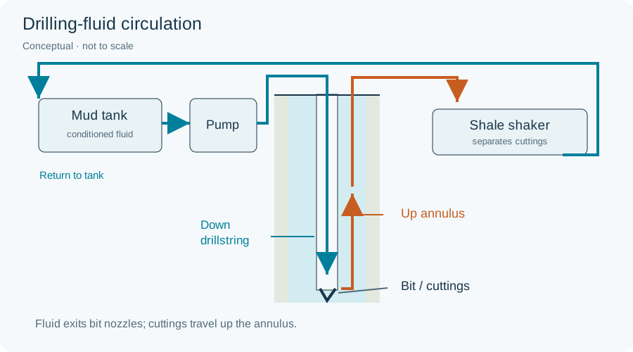
Cuttings travel from the bit to the surface through the annulus. Their collection time therefore differs from the time the rock was drilled. Lag interpretation must account for the circulation and operating context; surface arrival depth cannot simply be assumed to equal the depth at which a cutting originated.
Measured depth follows the borehole, while true vertical depth is a vertical distance from a defined datum. Confirm the datum and units before combining samples, surveys and reference logs. The oilfield glossary explains these terms and related drilling operations.
Connected tools for the geological team
Use GeoLink for rig-data connectivity, the striplog editor for reviewed geological records, and Infinity for Microsoft Teams for shared live and saved views.
Plan geological coverage
Contact Chaser Geological with the well location, drilling schedule, target formations, available data feeds and reporting requirements to discuss appropriate wellsite or remote support.