Three discoveries changed Turner Valley's future: Dingman No. 1 in 1914, Royalite No. 4 in 1924, and Turner Valley Royalties No. 1 in 1936. Follow the gas and light liquids, deeper carbonate reservoir, major crude-oil development, company decisions and changing geological interpretations behind those dates. The full episode pairs Dorian's AI narration with 32 historical photographs, including original 1926 colour autochromes, and 12 explanatory diagrams. Photograph dates, identities, credits and rights notes accompany the illustrated transcript. This edition uses archival still photographs and original diagrams; historical film catalogue links are provided separately.
32 dated and credited historical photographs, 12 original conceptual diagrams and 75 narrated scenes. Original 1926 autochrome colour. Dorian AI narration. Historical motion-film links appear separately in the illustrated transcript. AI narration: Dorian.
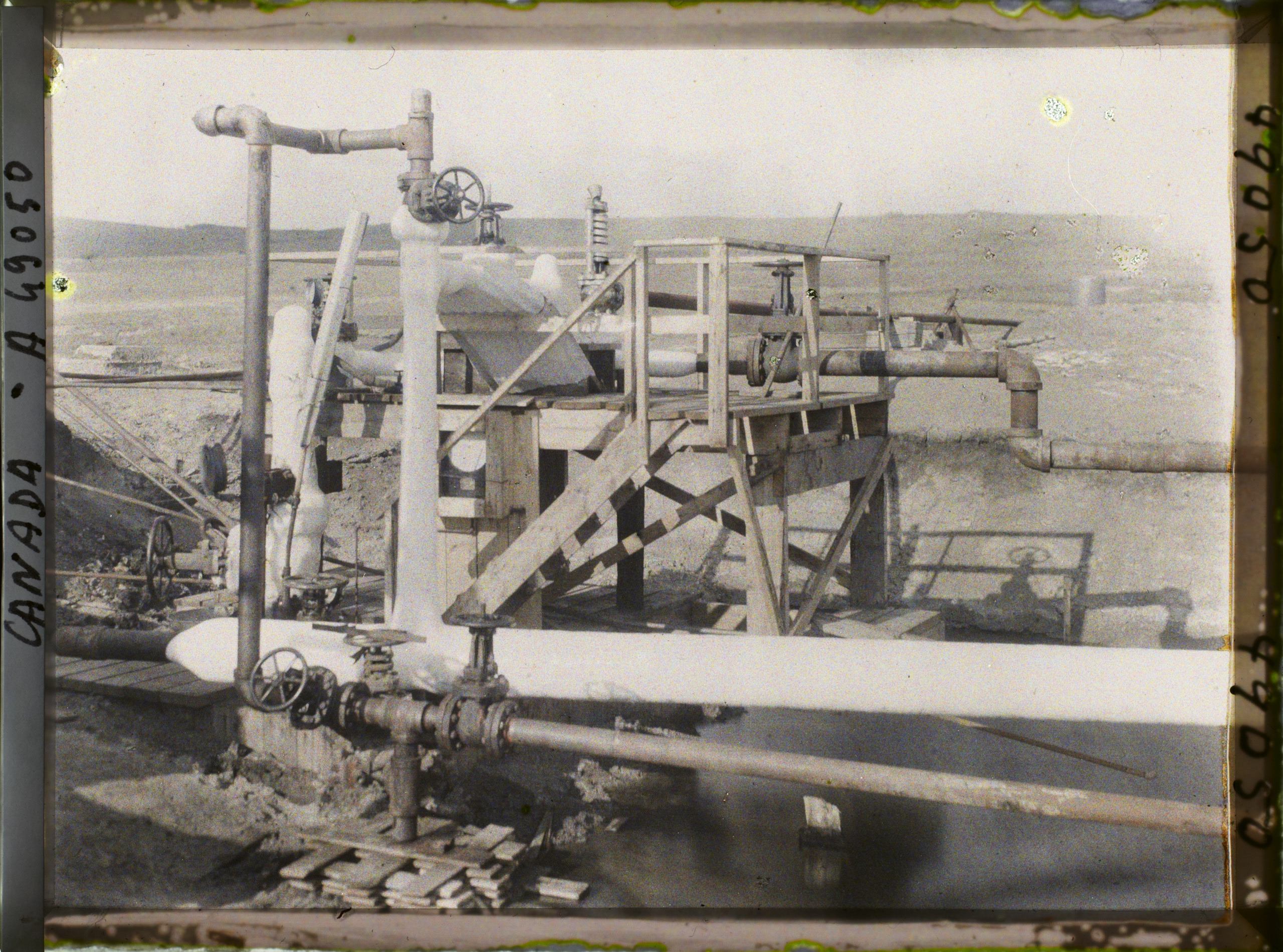
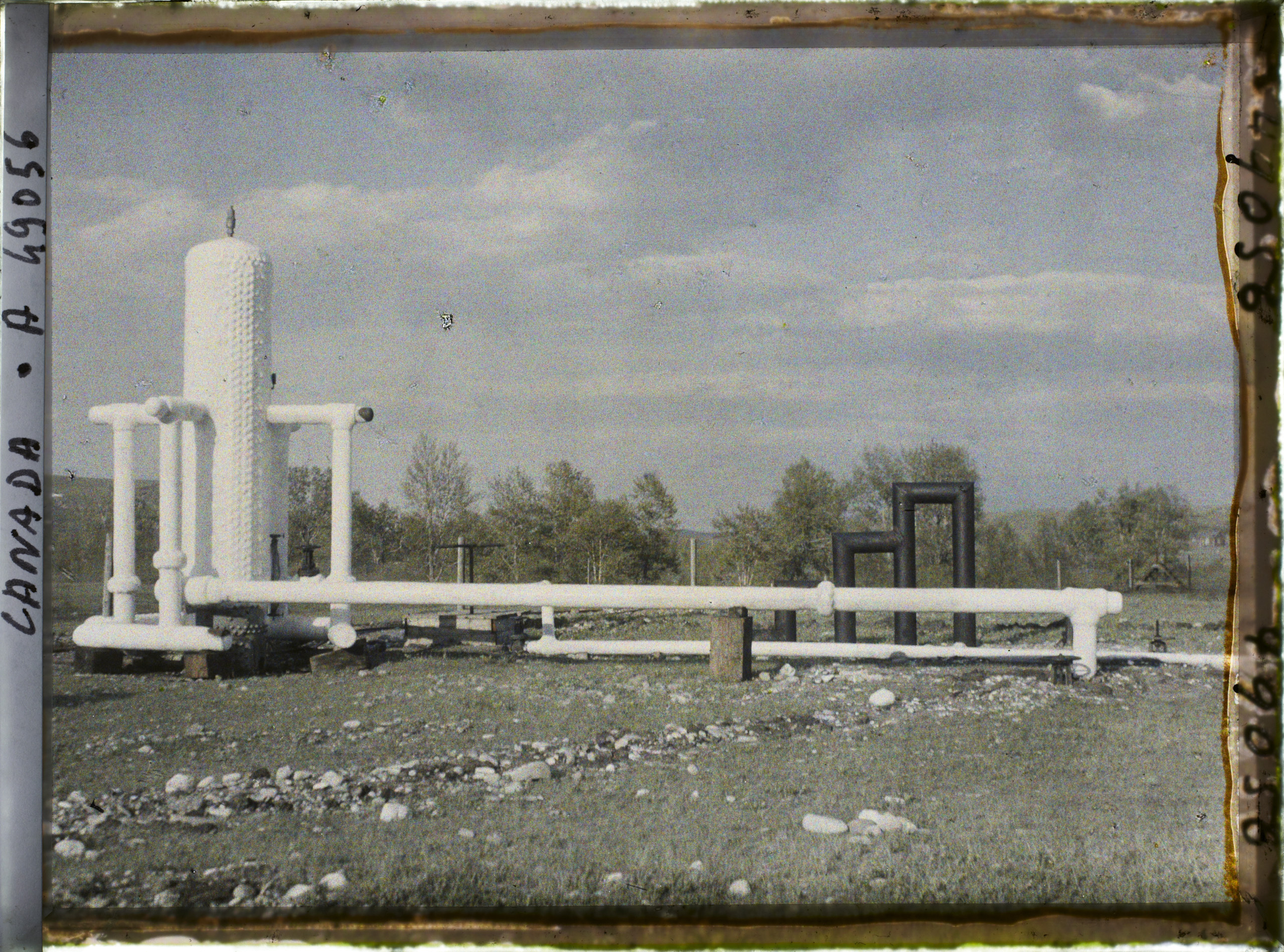
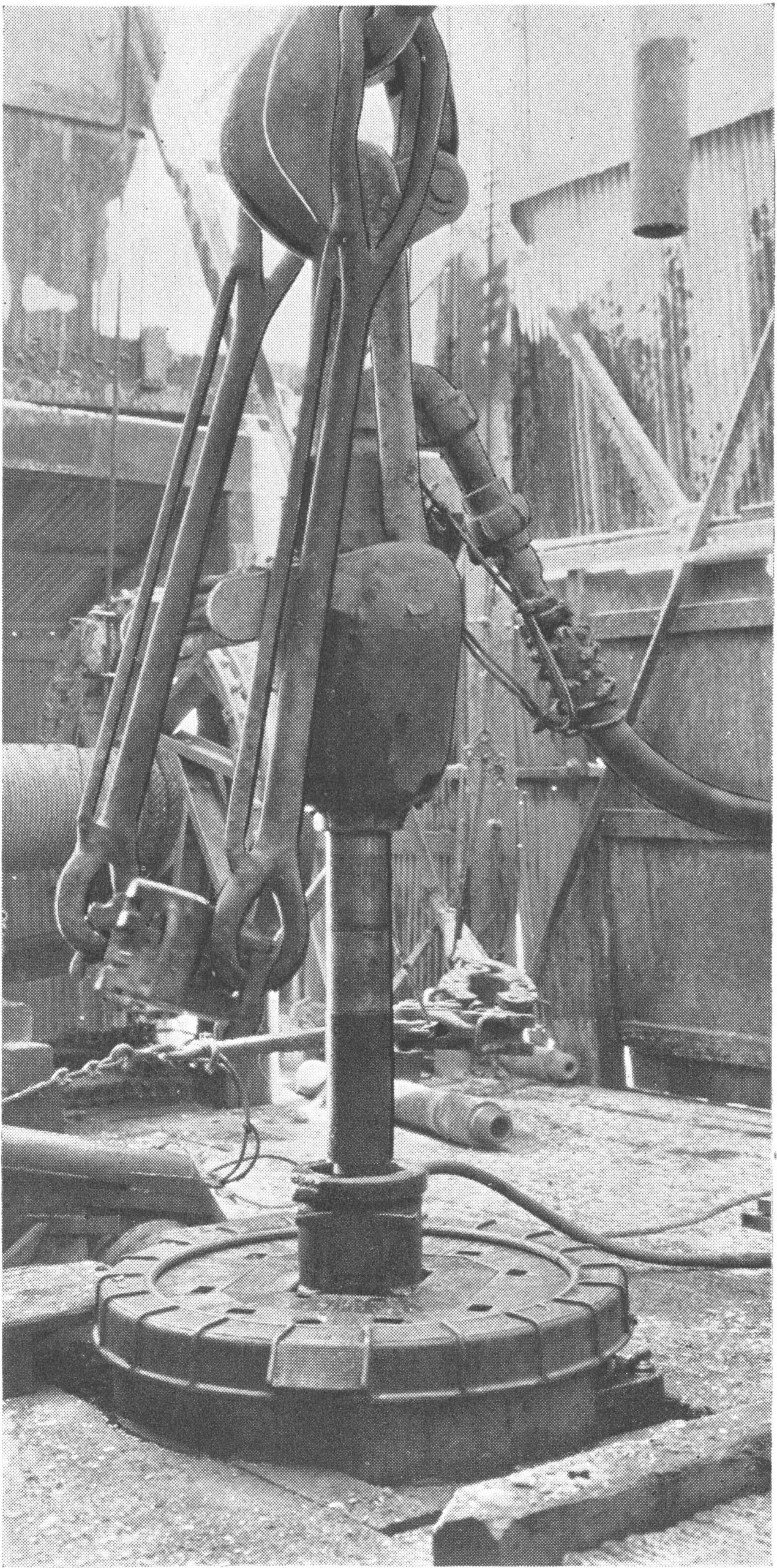
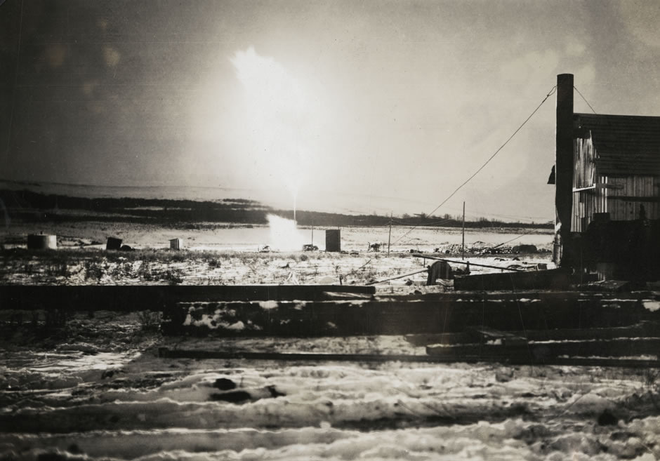
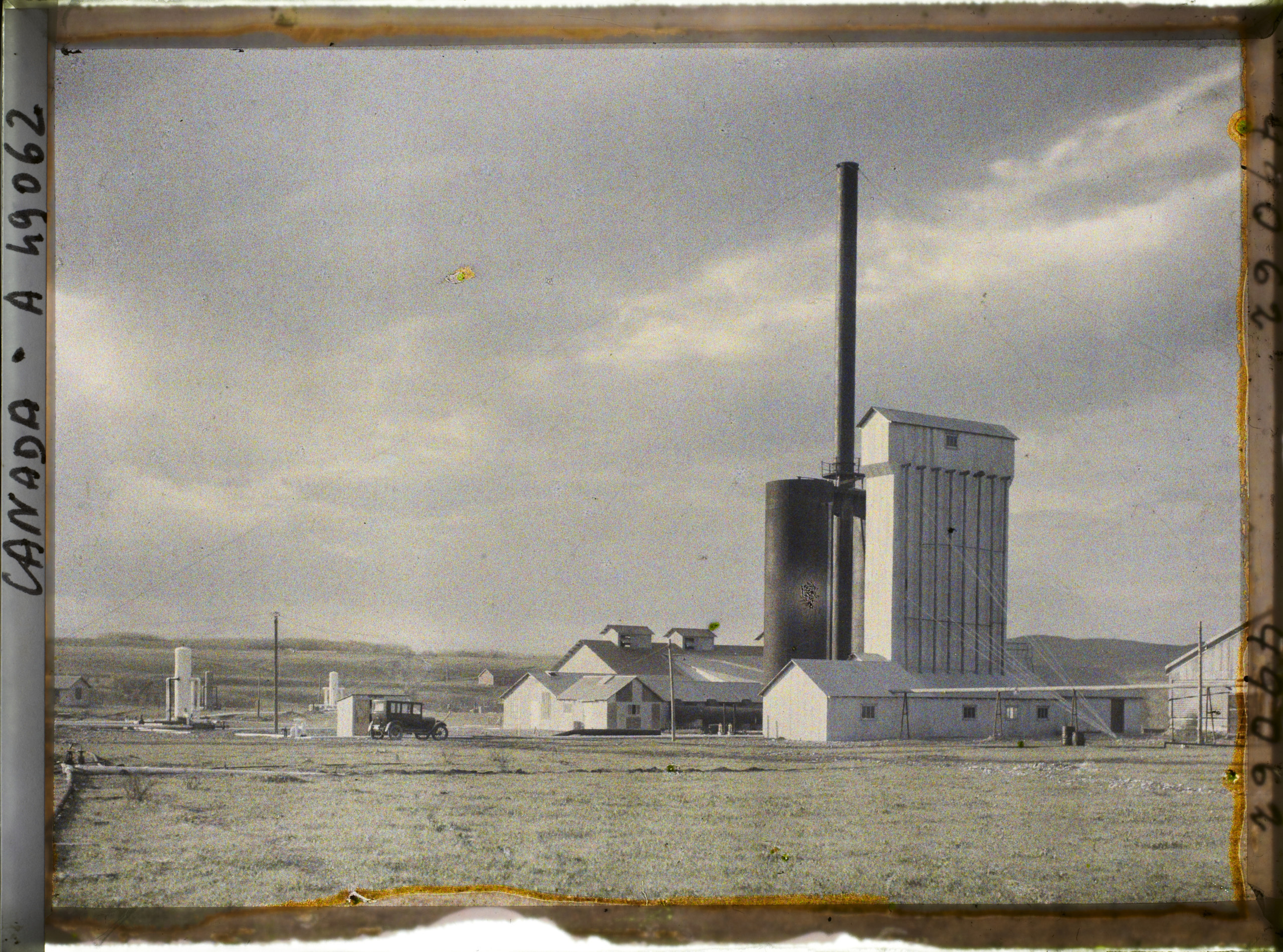
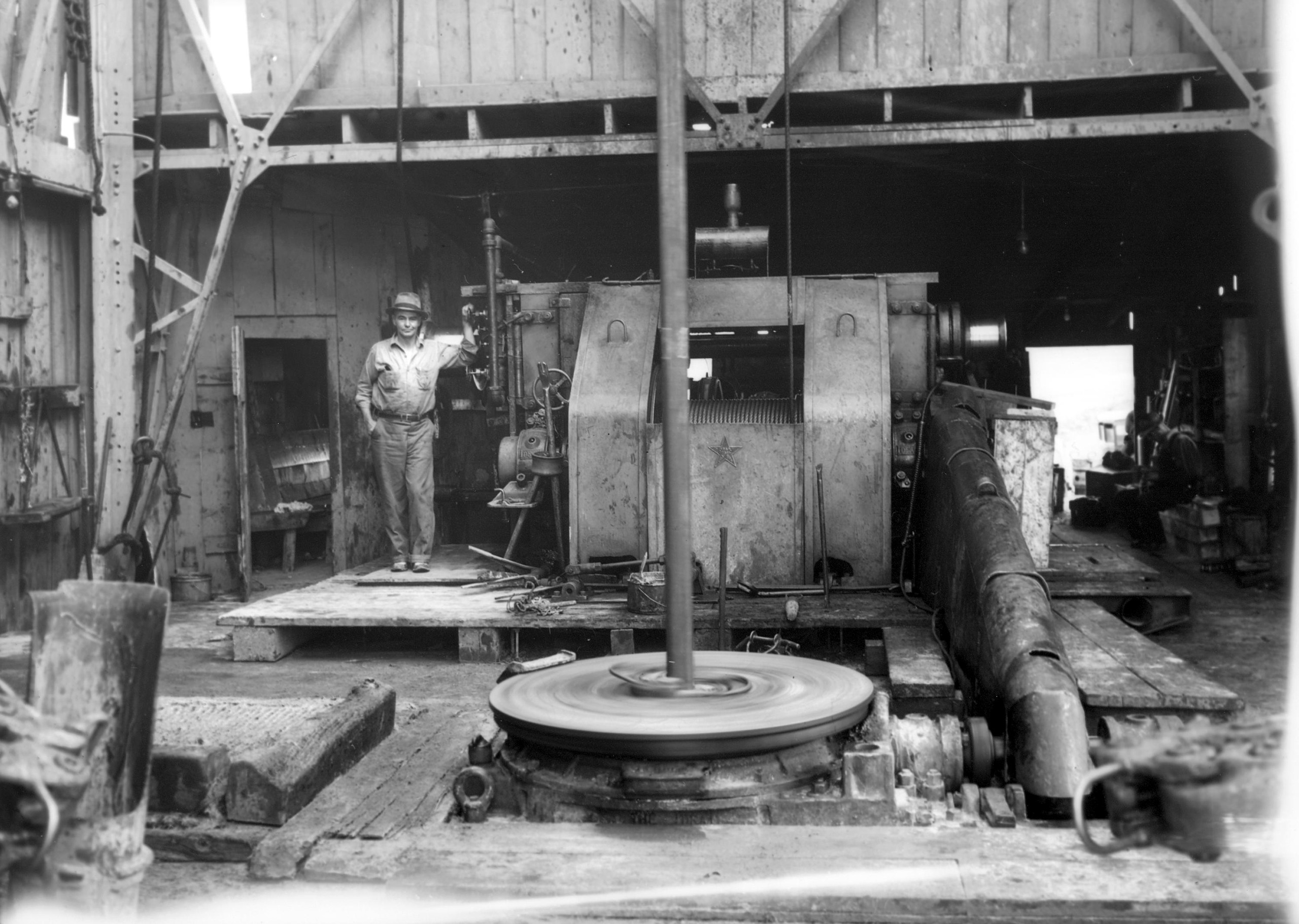
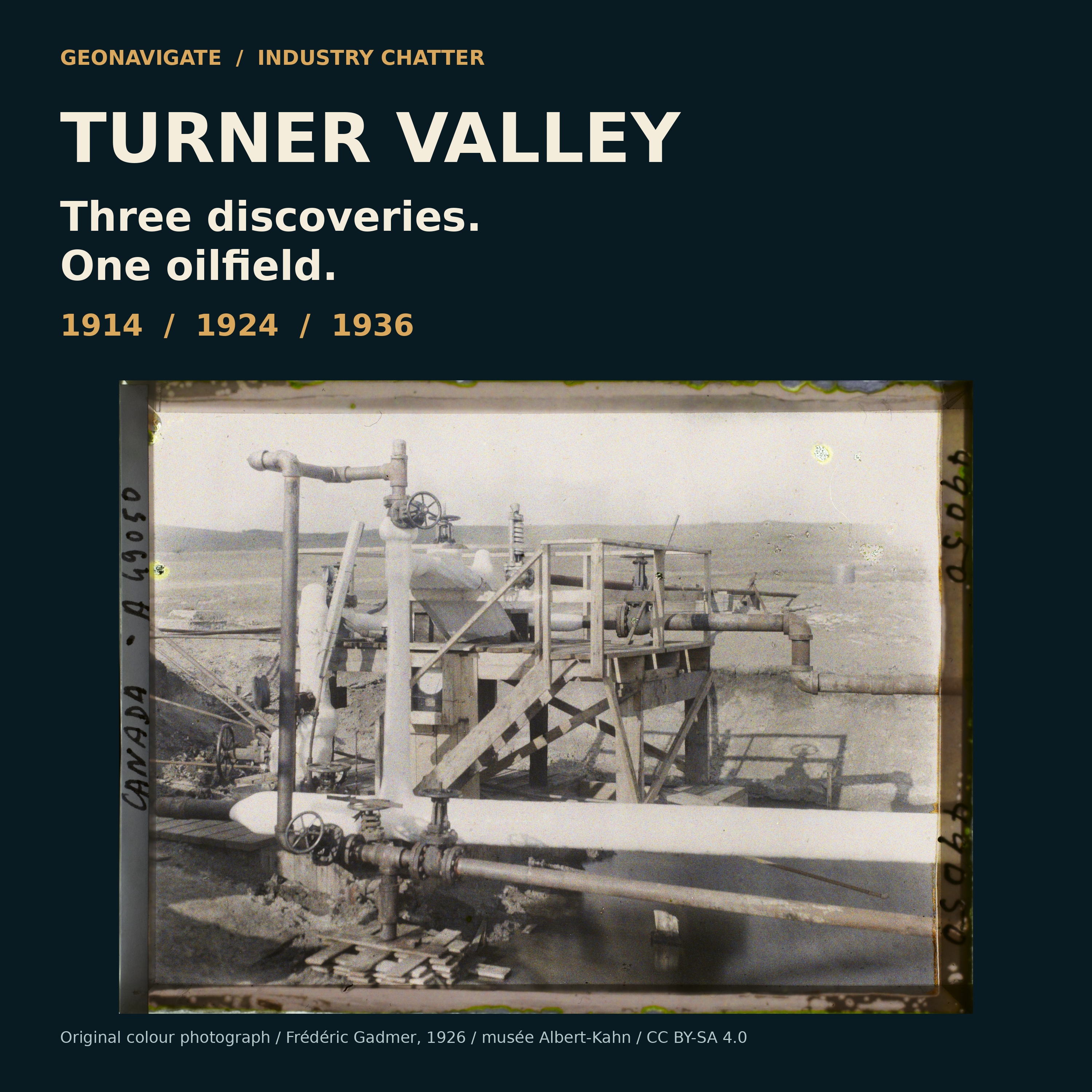
Episode visualOverall installations at Royalite No.4, photographed in original autochrome colour by Frédéric Gadmer on 13 May 1926. Not AI colourization.Frédéric Gadmer / Département des Hauts-de-Seine, musée Albert-Kahn, A49050 · CC BY-SA 4.0 · Image record ↗ · Licence ↗Episode visualEquipment at Royalite No.4, photographed in original autochrome colour by Frédéric Gadmer on 13 May 1926. Not AI colourization.Frédéric Gadmer / Département des Hauts-de-Seine, musée Albert-Kahn, A49056 · CC BY-SA 4.0 · Image record ↗ · Licence ↗Episode visualSwivel and hose circulate mud. Turner Valley field-development context, published Summer 1938. Exact capture date is unstated; this is not identified as the 1936 discovery well.Imperial Oil Review, Summer 1938, p. 5, figure 13; photographer uncredited. Scan: Alberta’s Energy Heritage. · Public domain in Canada — historical-photograph inference; no worldwide licence asserted · Image record ↗ · Rights basis ↗Source imageFire at Royalite No. 4, November 1924. Photograph supplied by Glenbow Archives; this is the 1924 fire, not the 1926 operating flare.Glenbow Archives, IP-6e-4-18; reproduced on Alberta’s Energy Heritage. · Public domain in Canada — historical-photograph inference; no worldwide licence asserted · Image record ↗ · Rights basis ↗Episode visual1914 sandstone gas and light liquids, 1924 deep carbonate gas and condensate, and 1936 major crude-oil development mark different chapters. Selected turning points in a longer field history; these were not the only discoveries.GeoNavigate Industry Chatter — original explanatory diagram · Original GeoNavigate production asset; source references concern the explanation, not ownership of the drawing. · Image record ↗
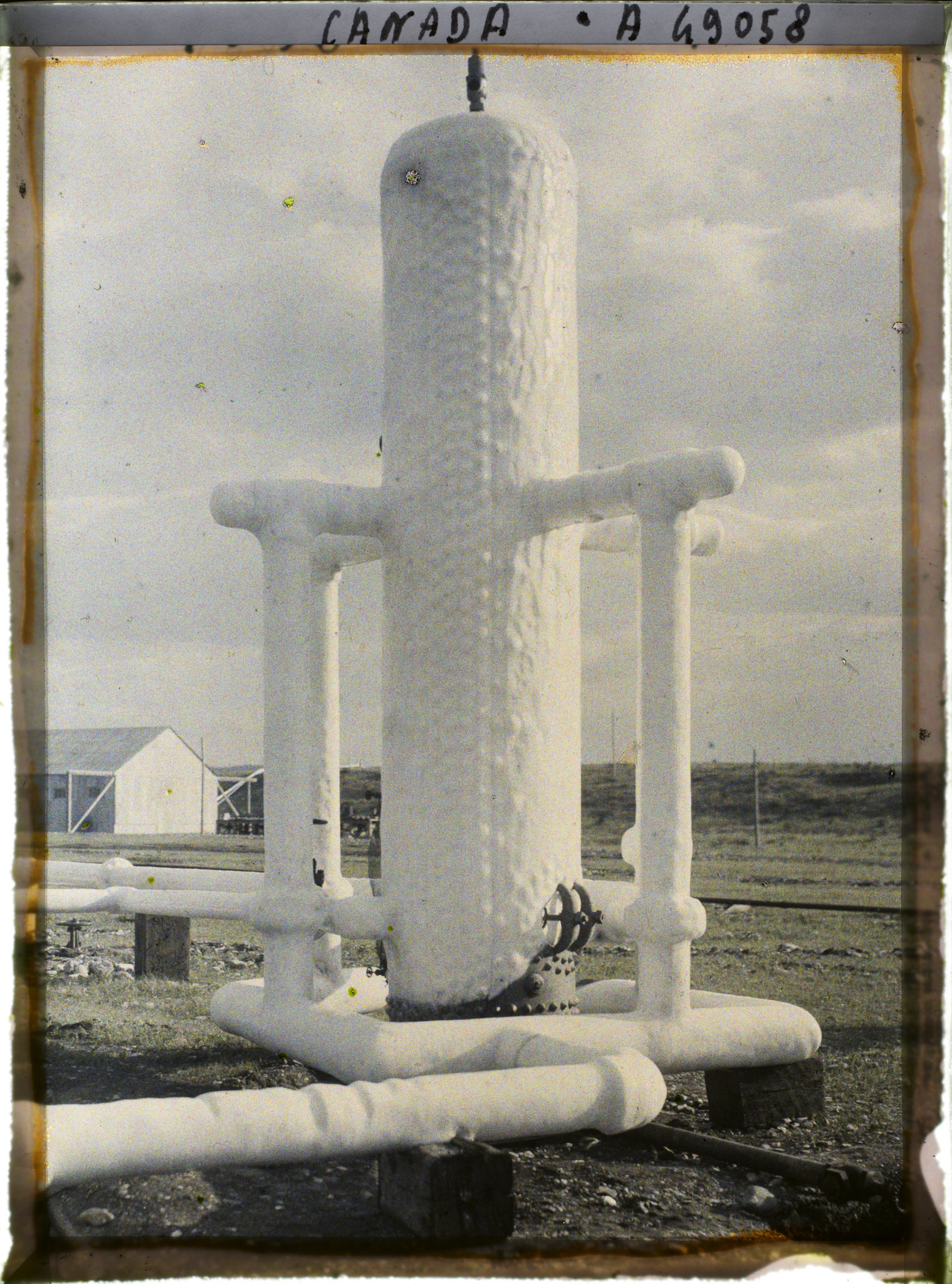
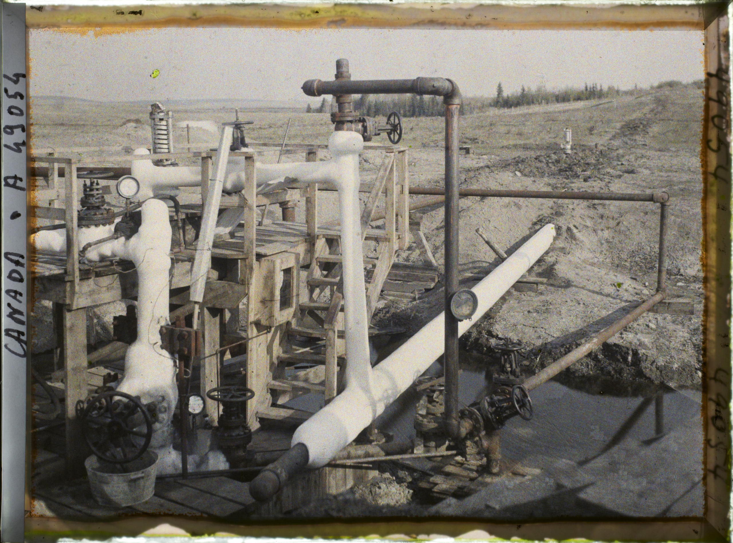
Look closely at the pipes, the valve wheels and the pale steel vessels. The photograph is in colour, and that colour belongs to nineteen twenty-six. It was recorded on an autochrome glass plate at Royalite Number Four in Turner Valley. Nobody has painted colour onto a black-and-white picture for this episode.
The equipment looks settled. But two years earlier, Royalite Number Four had become a dangerous, uncontrolled well. Twelve years earlier, another well had started the valley's first petroleum rush. And ten years after this photograph, a different discovery would open the major crude-oil development.
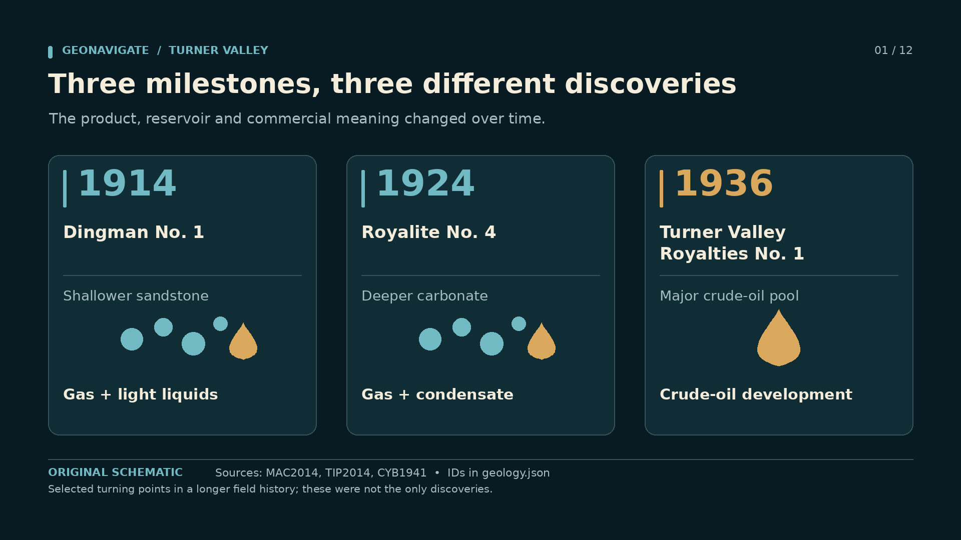
Three dates frame our story: nineteen fourteen, nineteen twenty-four and nineteen thirty-six. They were not the only discoveries in Turner Valley. They were turning points that changed what people believed the field could produce.
This is GeoNavigate Industry Chatter, narrated by the AI voice Dorian. Our episode is Turner Valley: Three Discoveries, One Oilfield. We will follow the wells, the working photographs, and the differences between a gas discovery, a valuable liquid recovered from gas, and a producing oil pool.
A successful well was the beginning of an argument with the rock. Each new well changed that argument.
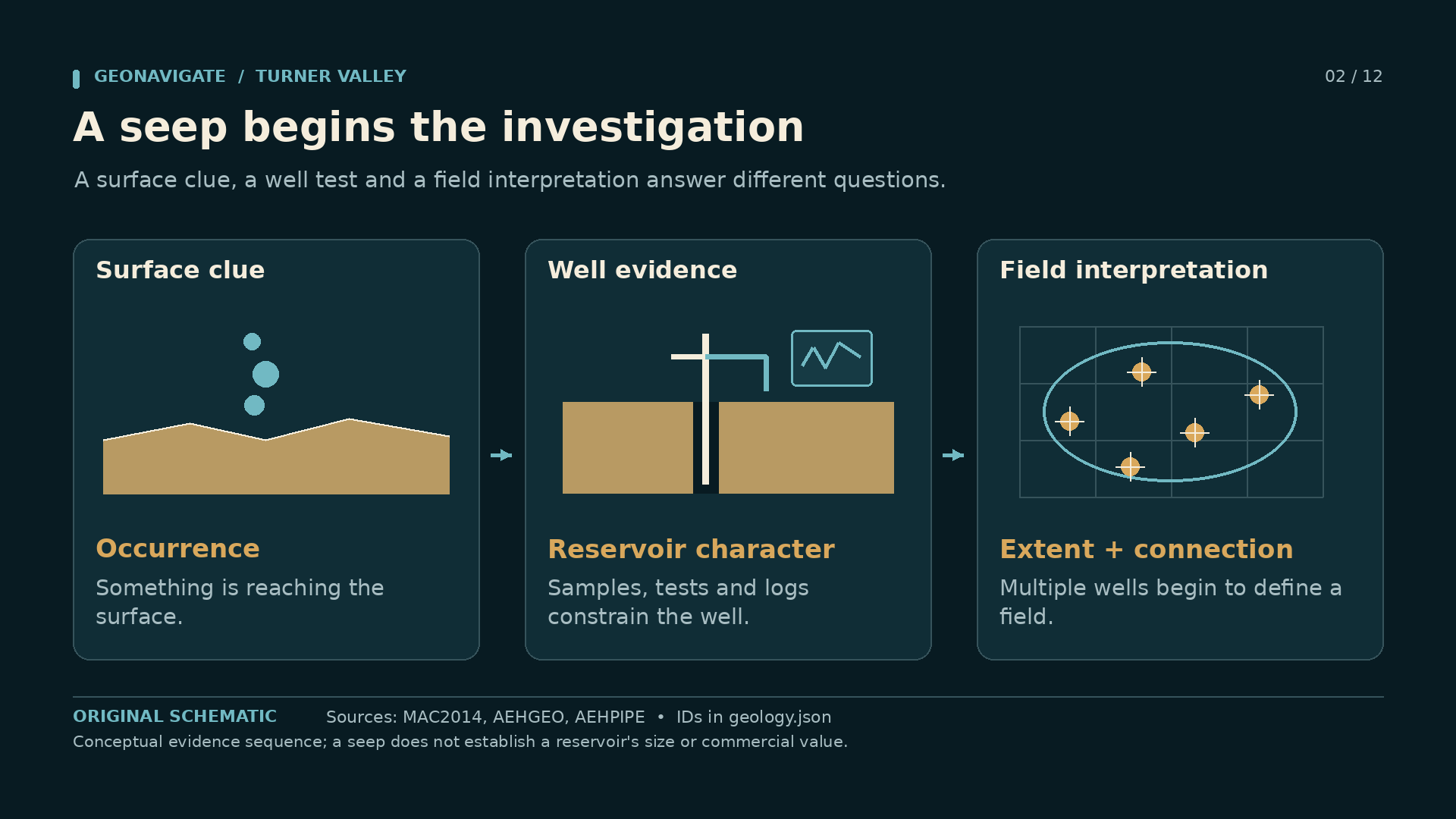
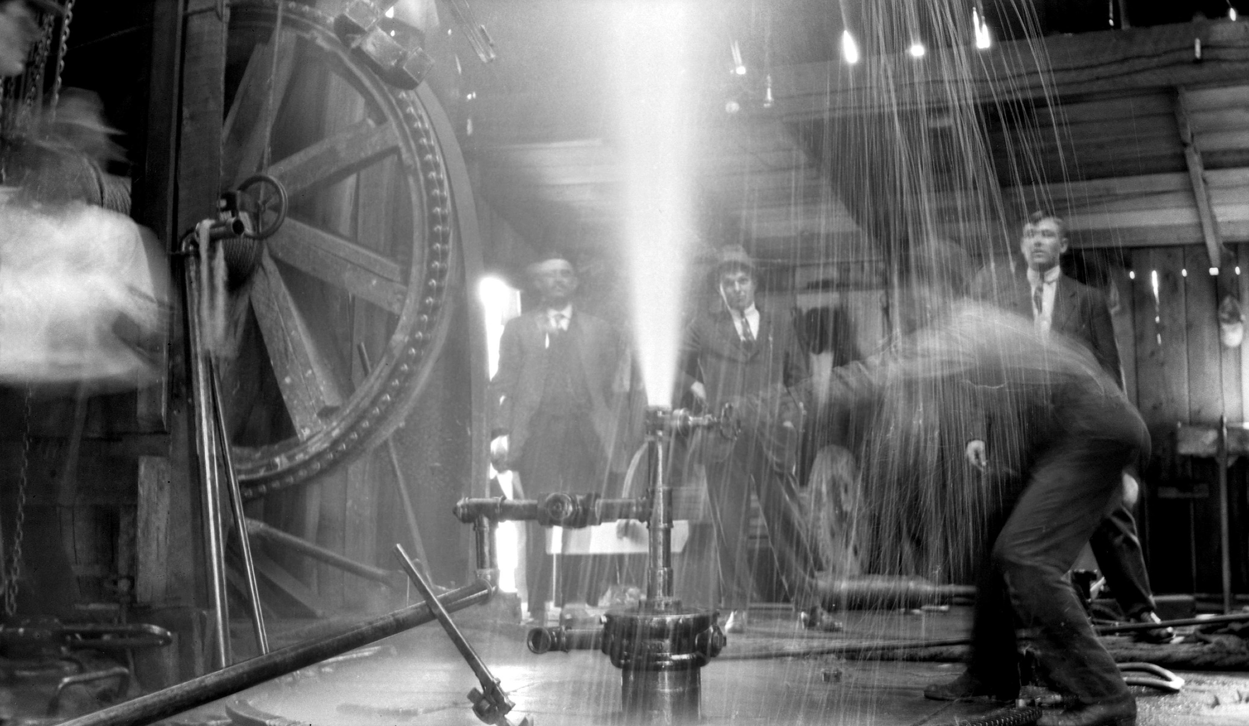
Source imageDrillers on the Dingman well floor, 1914. The archive caption and visible negative inscription disagree on the month/day.Provincial Archives of Alberta, P1303 · No known copyright restrictions — official institution on Flickr Commons · Image record ↗ · Licence ↗Episode visualDerrick at the Dingman well, 1914. Original photograph by Lane and Mitchell.Lane and Mitchell / British Library, HS85/10/28963 · PD-Canada and PD-US-expired, as tagged on Commons · Image record ↗ · Licence ↗Source imageGusher at the Dingman well, photographed in 1914 by Lane and Mitchell. The archive gives the year, not an exact day.Lane and Mitchell / British Library, HS85/10/28962 · PD-Canada and PD-US-expired, as tagged on Commons · Image record ↗ · Licence ↗Conceptual diagramA seep is evidence of a surface occurrence. A well characterizes a subsurface interval. Field interpretation requires additional data. Conceptual evidence sequence; a seep does not establish a reservoir's size or commercial value.GeoNavigate Industry Chatter — original explanatory diagram · Original GeoNavigate production asset; source references concern the explanation, not ownership of the drawing. · Image record ↗
The story begins beside the Sheep River, southwest of Calgary. William Stewart Herron noticed gas escaping at surface. A seep was visible evidence that something underground was generating, carrying or releasing gas. It did not reveal the size of a reservoir, the depth of a commercial target, or the rate at which a well might produce.
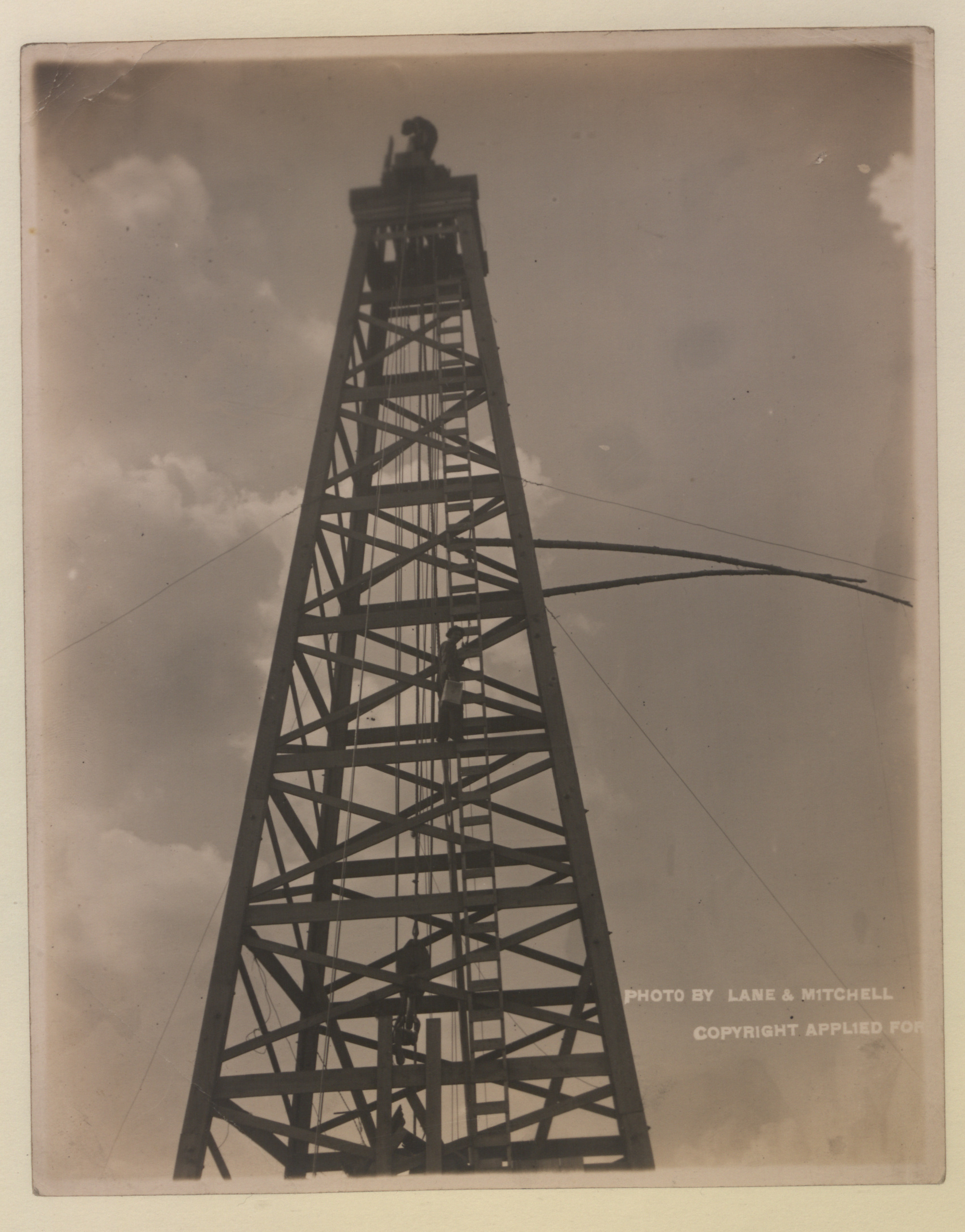
Herron acquired interests in the area and worked with Archibald Dingman and Calgary investors to form Calgary Petroleum Products. Drilling began in nineteen thirteen. Money, land rights, equipment and a crew had to come together before the geological idea could be tested.
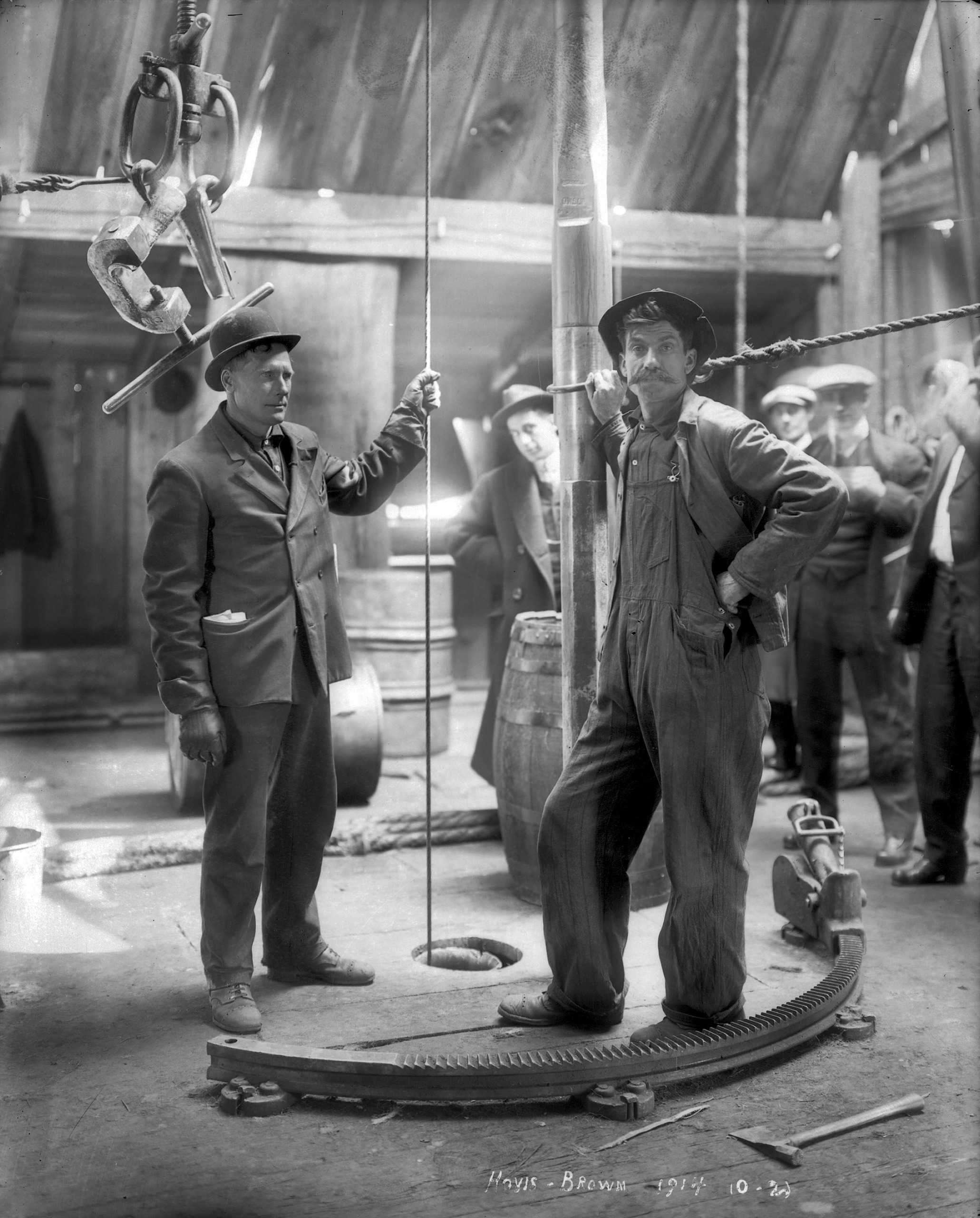
The surviving photographs bring that work down to human scale. Men stand beside drill pipe and hoisting equipment inside the derrick. Their clothes, tools and surroundings belong to that particular working world. These are photographs associated with the Dingman well, not actors placed around a modern rig.
For a geologist, the decision remains recognizable. Start with an observation. Develop an explanation. Commit to a test that can prove the explanation incomplete.
The seep justified investigation. Only the well could tell the investors whether a useful accumulation lay beneath their land. And even a flowing discovery would leave the larger field mostly unknown.
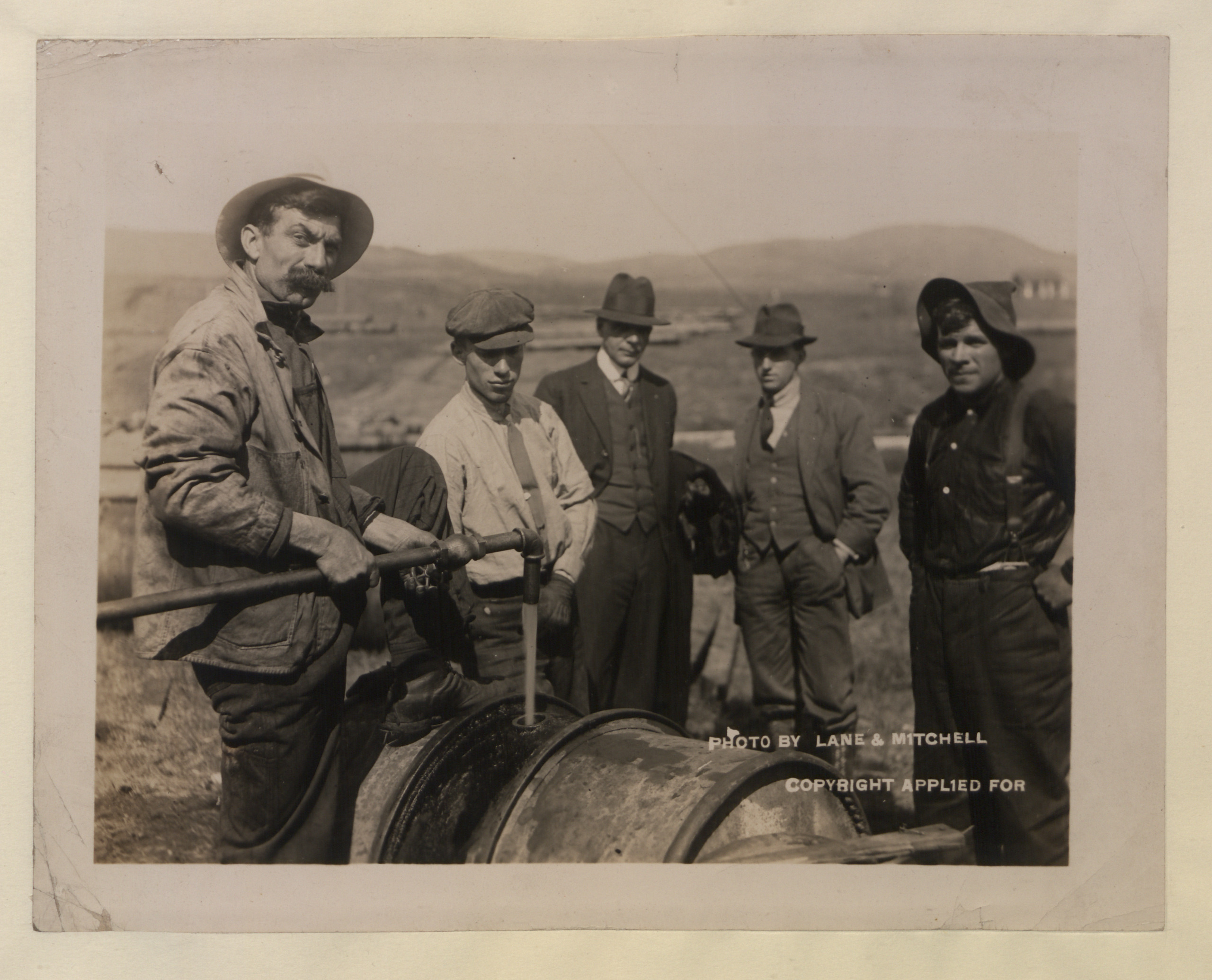
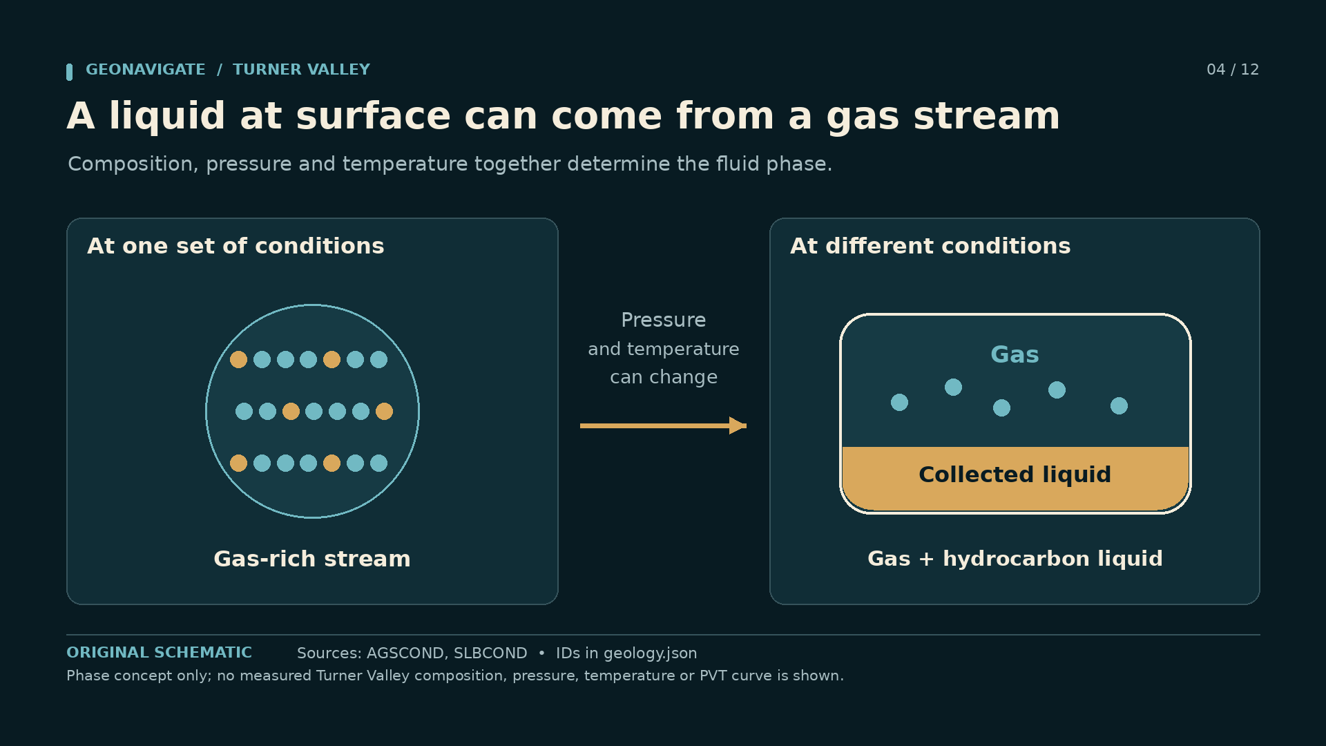
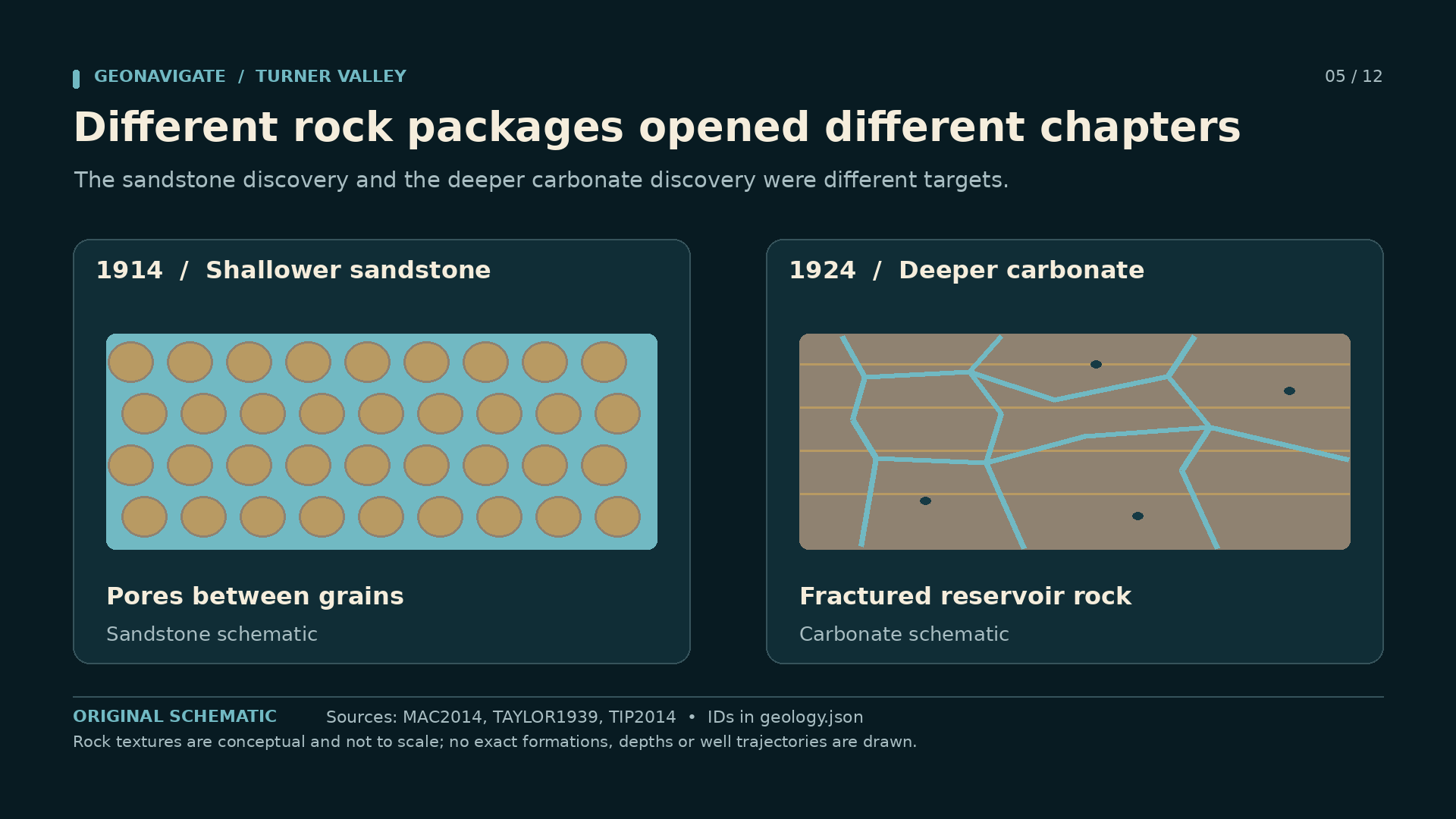
Episode visualDingman No. 1 blowing inside its derrick, photographed on 14 May 1914.Provincial Archives of Alberta, P1883 · No known copyright restrictions — official institution on Flickr Commons · Image record ↗ · Licence ↗Episode visualDerrick at the Dingman well, 1914. Original photograph by Lane and Mitchell.Lane and Mitchell / British Library, HS85/10/28963 · PD-Canada and PD-US-expired, as tagged on Commons · Image record ↗ · Licence ↗Source imageWorkers filling drums at the Dingman well, 1914. The original archive caption calls the liquid oil; that wording does not establish a conventional crude-oil reservoir.Lane and Mitchell / British Library, HS85/10/28964 · PD-Canada and PD-US-expired, as tagged on Commons · Image record ↗ · Licence ↗Episode visualA gas-rich stream can yield liquid as conditions change. Surface condensate alone does not establish a conventional crude-oil pool underground. Phase concept only; no measured Turner Valley composition, pressure, temperature or PVT curve is shown.GeoNavigate Industry Chatter — original explanatory diagram · Original GeoNavigate production asset; source references concern the explanation, not ownership of the drawing. · Image record ↗Conceptual diagramDingman No.1 produced from sandstone. Royalite No.4 entered deeper fractured Mississippian carbonates. Their diagrams are separate rock-type concepts. Rock textures are conceptual and not to scale; no exact formations, depths or well trajectories are drawn.GeoNavigate Industry Chatter — original explanatory diagram · Original GeoNavigate production asset; source references concern the explanation, not ownership of the drawing. · Image record ↗
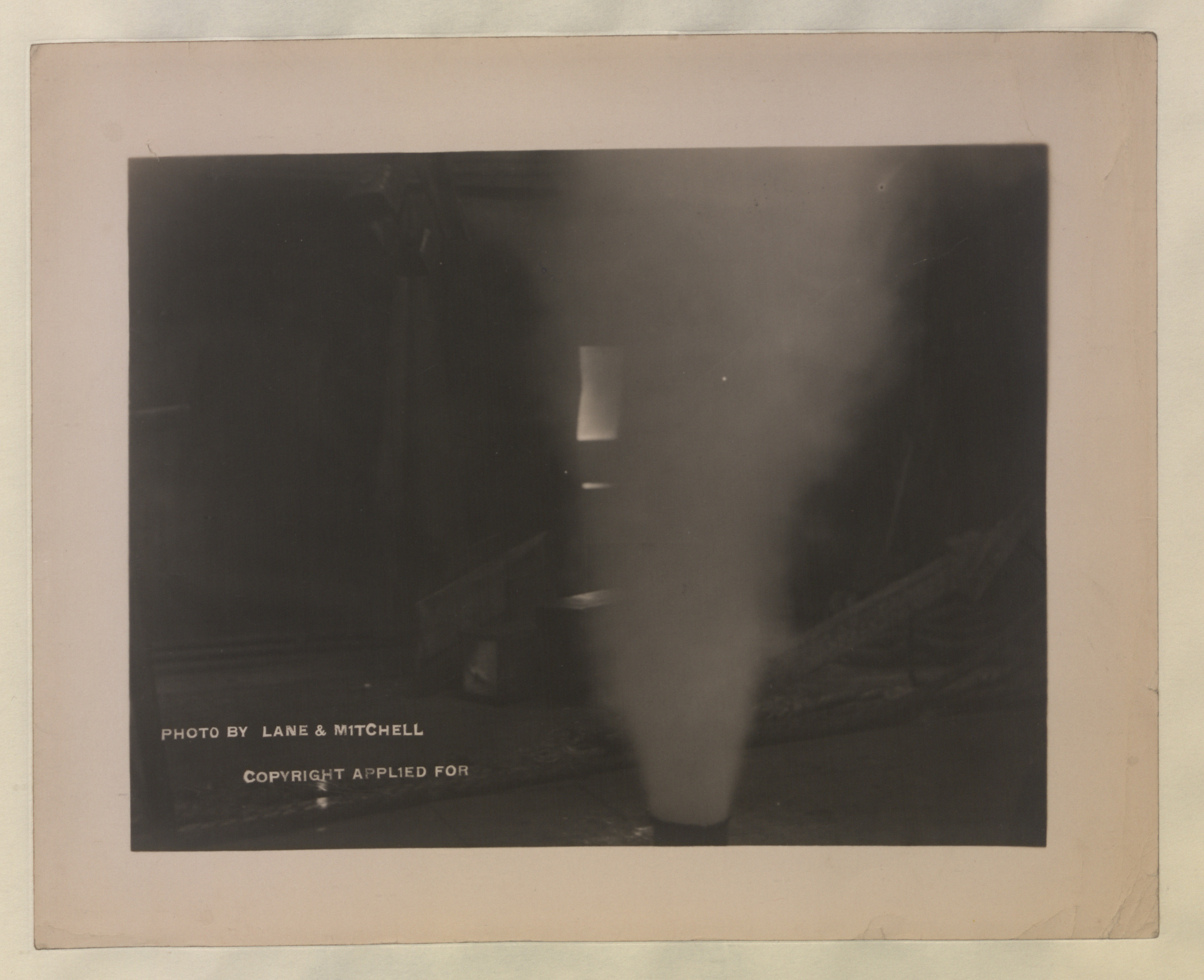
On May fourteenth, nineteen fourteen, the Dingman Number One well came in. The discovery produced gas carrying valuable light hydrocarbons. Contemporary language often called the recovered liquid natural gasoline or naphtha. That is why a story remembered as an oil rush begins with so much discussion of gas.
The first producing interval was in shallower sandstone strata. Some widely repeated summaries name a Devonian reef, but that conflicts with the more detailed geological accounts. We will keep the description at the level the evidence supports: sandstone, above the deeper carbonate reservoir that became important later.
Photographs of the derrick, the flowing well and men filling drums show the new business taking shape. They do not, by themselves, tell us how much of the underground petroleum existed as gas or liquid at reservoir pressure.
That distinction matters. A container filled at surface records a surface product. It does not identify the original reservoir fluid without further evidence.
Dingman Number One established a working petroleum discovery and drew attention to Turner Valley. It did not settle where all the oil lay, how the structure was assembled, or whether the same results would continue across the surrounding country. Those questions would occupy the next generation.
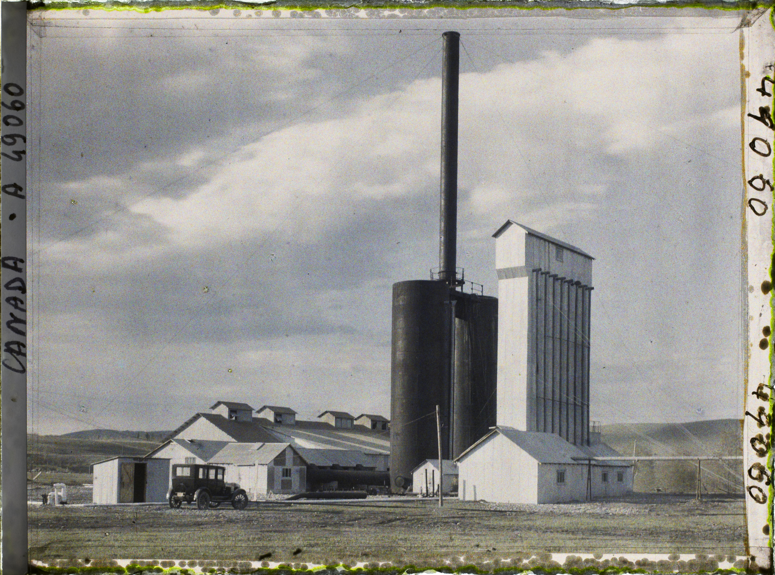
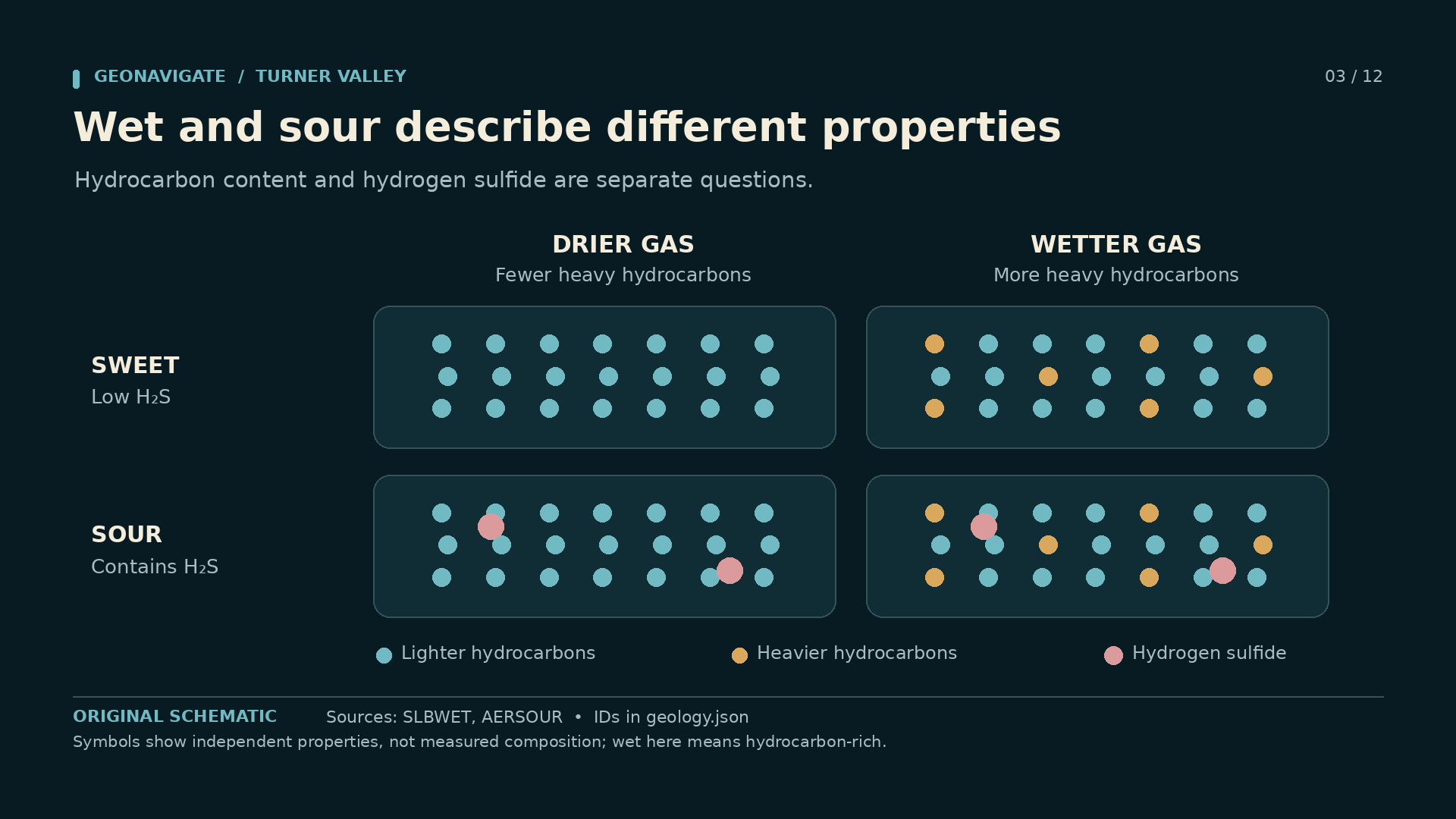
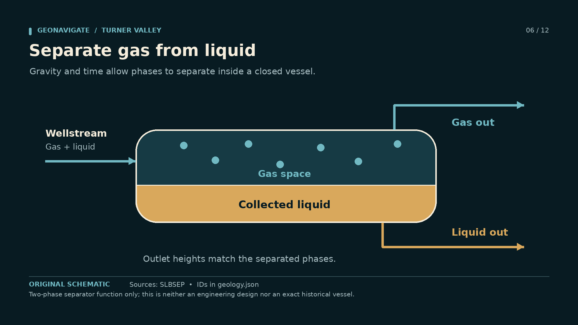
Episode visualSmith separator at Royalite No.4, photographed in original autochrome colour by Frédéric Gadmer on 13 May 1926. Not AI colourization.Frédéric Gadmer / Département des Hauts-de-Seine, musée Albert-Kahn, A49058 · CC BY-SA 4.0 · Image record ↗ · Licence ↗Episode visualSoda-ash purification plant at Royalite No.4, photographed in original autochrome colour by Frédéric Gadmer on 13 May 1926. Not AI colourization.Frédéric Gadmer / Département des Hauts-de-Seine, musée Albert-Kahn, A49060 · CC BY-SA 4.0 · Image record ↗ · Licence ↗Original diagramWet/dry in this diagram concerns the hydrocarbon mix. Sweet/sour concerns hydrogen sulfide. A gas may have either combination. Symbols show independent properties, not measured composition; wet here means hydrocarbon-rich.GeoNavigate Industry Chatter — original explanatory diagram · Original GeoNavigate production asset; source references concern the explanation, not ownership of the drawing. · Image record ↗Episode visualA gas-rich stream can yield liquid as conditions change. Surface condensate alone does not establish a conventional crude-oil pool underground. Phase concept only; no measured Turner Valley composition, pressure, temperature or PVT curve is shown.GeoNavigate Industry Chatter — original explanatory diagram · Original GeoNavigate production asset; source references concern the explanation, not ownership of the drawing. · Image record ↗Episode visualThe gas outlet draws from the upper gas space, while liquid leaves below the liquid level. This physical separation does not itself sweeten sour gas. Two-phase separator function only; this is neither an engineering design nor an exact historical vessel.GeoNavigate Industry Chatter — original explanatory diagram · Original GeoNavigate production asset; source references concern the explanation, not ownership of the drawing. · Image record ↗
Two words help untangle Turner Valley's history: wet and sour. They describe different properties.
Wet gas contains appreciable heavier hydrocarbons that can be recovered as liquids. In this usage, wet does not simply mean that the gas contains water. Sour gas contains hydrogen sulfide. A gas can be wet and sour at the same time, so recovering a liquid product does not automatically solve the gas-treatment problem.
Pressure, temperature and composition determine whether a hydrocarbon mixture is present as one phase or more than one. As production reaches different conditions at surface, liquids can separate from the stream. A separator provides space and controlled outlets for different phases. It does not manufacture oil from nothing.
Nor is all liquid petroleum interchangeable. A light natural-gas liquid, a barrel of conventional crude, and a finished motor fuel are different products. Their composition, handling and commercial value differ.
These distinctions explain why a field can produce valuable barrels before its major crude-oil development begins. They also explain why the photographs of Turner Valley show so much processing equipment. Discovering petroleum solved one problem. Separating, treating and selling it created several more.
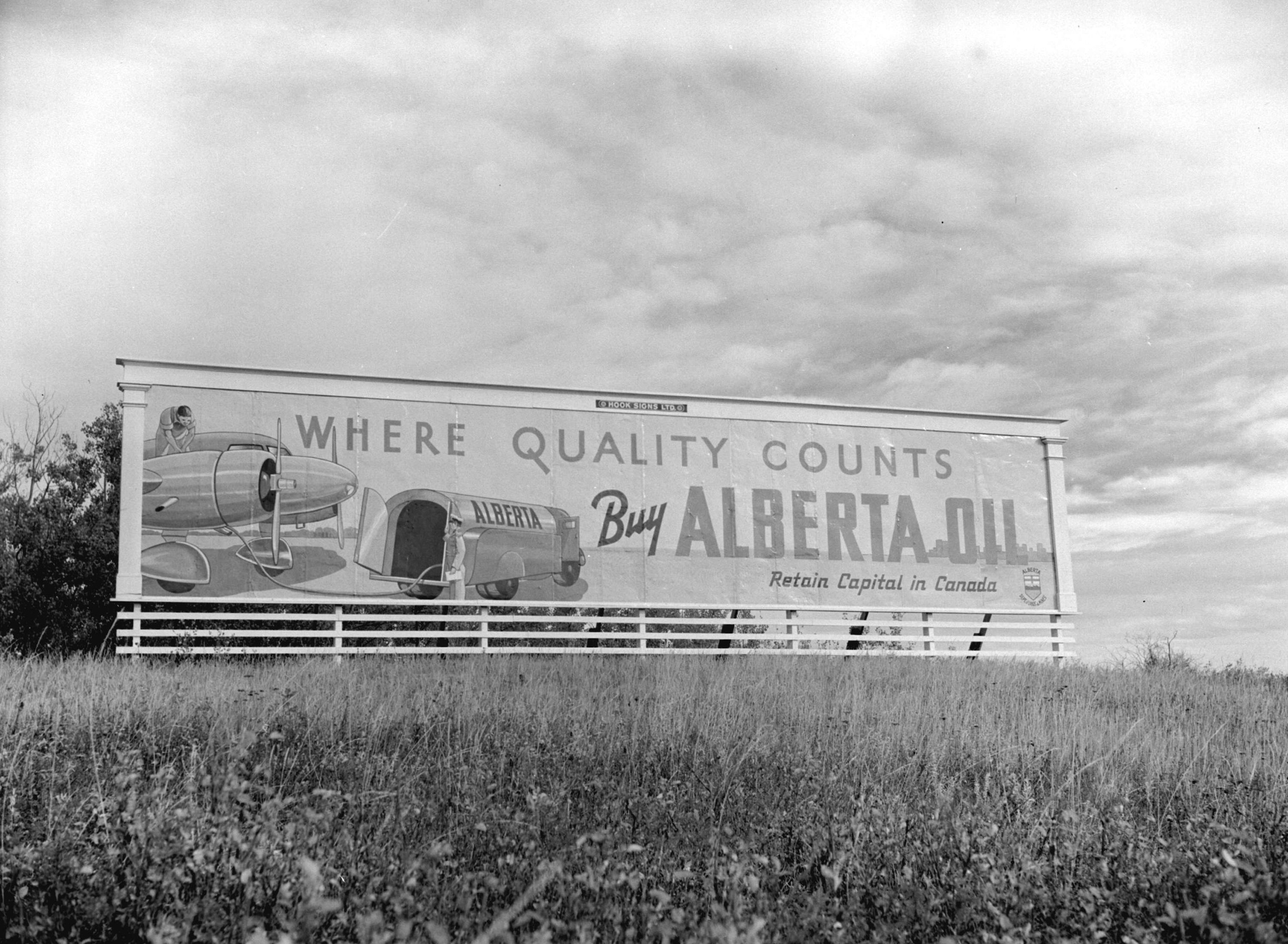
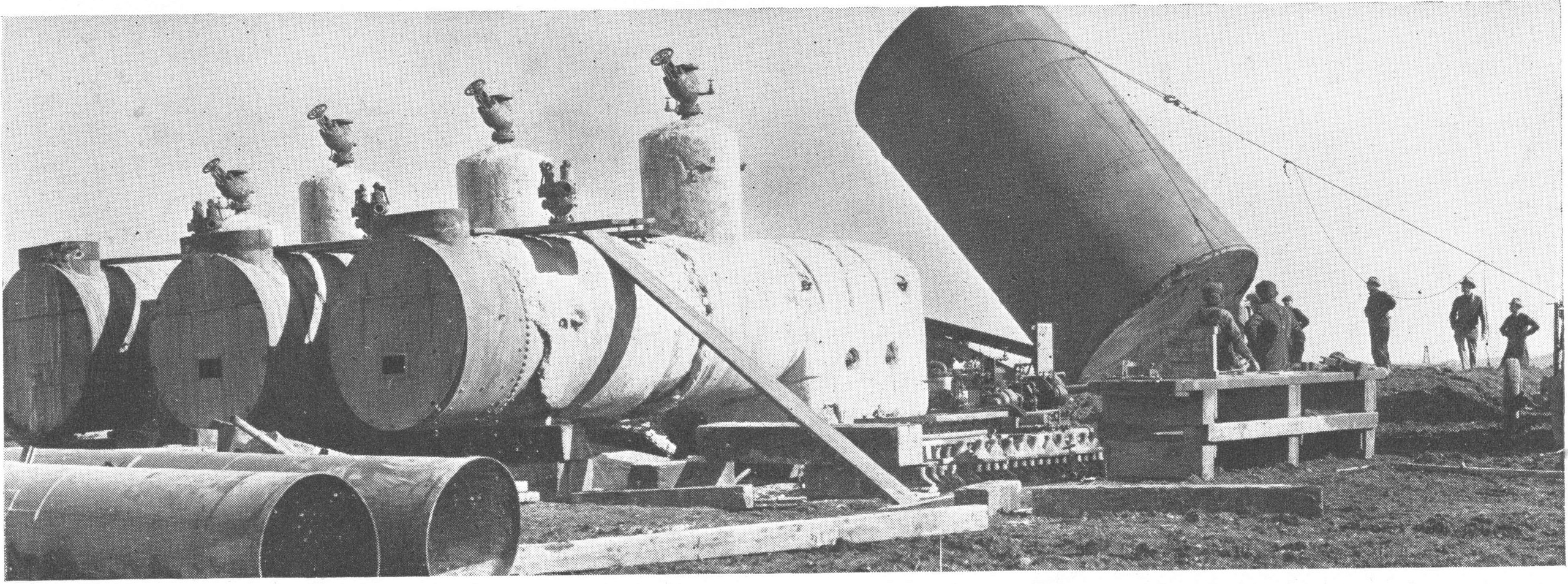
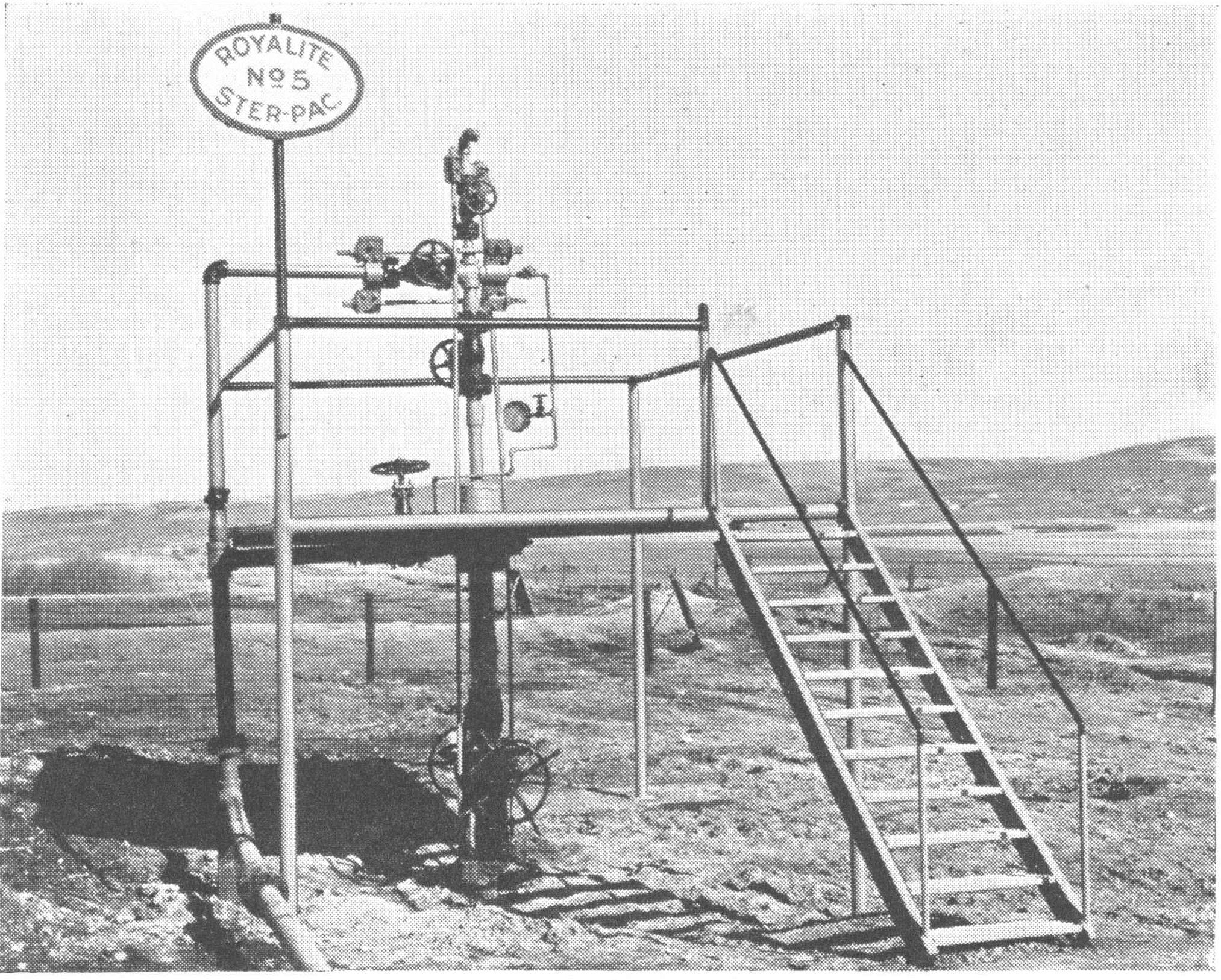
Episode visualPipeline route at Royalite No.4, photographed in original autochrome colour by Frédéric Gadmer on 13 May 1926. Not AI colourization.Frédéric Gadmer / Département des Hauts-de-Seine, musée Albert-Kahn, A49054 · CC BY-SA 4.0 · Image record ↗ · Licence ↗Episode visualA billboard promoting Turner Valley oil, 1940. Exact billboard location has not been independently verified.Don Coltman / Steffens-Colmer Studios; City of Vancouver Archives; original source image A07115. · Wikimedia Commons marks this photograph public domain in Canada (PD-Canada) and the United States (PD-1996). · Image record ↗ · Licence ↗Episode visualBoilers and water tanks arrive. Turner Valley field-development context, published Summer 1938. Exact capture date is unstated; this is not identified as the 1936 discovery well.Imperial Oil Review, Summer 1938, p. 4, figure 8; photographer uncredited. Scan: Alberta’s Energy Heritage. · Public domain in Canada — historical-photograph inference; no worldwide licence asserted · Image record ↗ · Rights basis ↗Episode visualProducing wellhead marked Royalite No. 5, published in the Summer 1938 photo essay. Exact capture date is unstated. This is not Turner Valley Royalties No. 1.Imperial Oil Review, Summer 1938, p. 7, figure 20; photographer uncredited. Scan: Alberta’s Energy Heritage. · Public domain in Canada — historical-photograph inference; no worldwide licence asserted · Image record ↗ · Rights basis ↗
The first discovery created opportunity, but a company still had to survive interruptions, operating costs and a changing market. A flowing well alone did not pay for every piece of infrastructure it required.
In October nineteen twenty, a fire and explosion badly damaged the Calgary Petroleum Products plant. The company lacked the resources to restore the operation on its own. In nineteen twenty-one, Imperial Oil acquired the operation and established Royalite to run the Turner Valley business.
This was a turning point in the company story. Imperial brought financial backing and a connection to a larger petroleum business. Royalite rebuilt processing capacity and developed transport links. Gas from Turner Valley could reach Calgary through a connection with the existing gas system.
The commercial question had changed. It was no longer only whether a driller could find hydrocarbons. It was whether a producer could recover the useful liquids, handle the gas, and deliver saleable products to a customer.
That combination helps explain Royalite's success. Wells, processing, pipelines and market access supported one another. A smaller operator with a promising well could still depend on somebody else's facilities. Geological success and business independence were not necessarily the same thing.
Episode visualEquipment at Royalite No.4, photographed in original autochrome colour by Frédéric Gadmer on 13 May 1926. Not AI colourization.Frédéric Gadmer / Département des Hauts-de-Seine, musée Albert-Kahn, A49056 · CC BY-SA 4.0 · Image record ↗ · Licence ↗Source imageFire at Royalite No. 4, November 1924. Photograph supplied by Glenbow Archives; this is the 1924 fire, not the 1926 operating flare.Glenbow Archives, IP-6e-4-18; reproduced on Alberta’s Energy Heritage. · Public domain in Canada — historical-photograph inference; no worldwide licence asserted · Image record ↗ · Rights basis ↗Conceptual diagramDingman No.1 produced from sandstone. Royalite No.4 entered deeper fractured Mississippian carbonates. Their diagrams are separate rock-type concepts. Rock textures are conceptual and not to scale; no exact formations, depths or well trajectories are drawn.GeoNavigate Industry Chatter — original explanatory diagram · Original GeoNavigate production asset; source references concern the explanation, not ownership of the drawing. · Image record ↗Conceptual diagramA simplified gas/oil/water arrangement is shown inside reservoir rock, with a pore-space inset. Real Turner Valley structure, contacts and connectivity are more complex. Conceptual connected trap, not an actual Turner Valley section; contacts, geometry and scale are illustrative.GeoNavigate Industry Chatter — original explanatory diagram · Original GeoNavigate production asset; source references concern the explanation, not ownership of the drawing. · Image record ↗Episode visualThe literature describes evolving interpretations, from mapped anticlines through thrust-related structures to triangle-zone and faulted-stack models. These cartoons do not reconstruct exact field geometry. Illustrative model families, not reproductions of published cross-sections or the exact geometry of Turner Valley.GeoNavigate Industry Chatter — original explanatory diagram · Original GeoNavigate production asset; source references concern the explanation, not ownership of the drawing. · Image record ↗
Royalite's Number Four well tested older rocks beneath the shallower sandstone section. Earlier gas encountered in the well did not end the search. Drilling continued toward a deeper target.
The important deeper discovery was in fractured Mississippian carbonate. This was a different reservoir setting from Dingman Number One. Carbonate rock can store and transmit petroleum through several kinds of pore space. Fractures can make a major difference to how a well communicates with that storage.
A geological drawing must be careful here. Showing one neat arch and placing every famous well into the same layer creates a misleading picture. The wells tested different intervals, and the field's structural interpretation continued to change as more evidence arrived.
In October nineteen twenty-four, Royalite Number Four blew in. Reports described a very large gas flow accompanied by light liquids. The discovery greatly increased the significance of the deeper carbonate reservoir.
It also turned a drilling achievement into an emergency. The company had reached a powerful petroleum system. Now the surface equipment and the people around it had to deal with flow that was not under control. The value of the discovery and the difficulty of controlling it arrived together.
Episode visualOverall installations at Royalite No.4, photographed in original autochrome colour by Frédéric Gadmer on 13 May 1926. Not AI colourization.Frédéric Gadmer / Département des Hauts-de-Seine, musée Albert-Kahn, A49050 · CC BY-SA 4.0 · Image record ↗ · Licence ↗Source imageFire at Royalite No. 4, November 1924. Photograph supplied by Glenbow Archives; this is the 1924 fire, not the 1926 operating flare.Glenbow Archives, IP-6e-4-18; reproduced on Alberta’s Energy Heritage. · Public domain in Canada — historical-photograph inference; no worldwide licence asserted · Image record ↗ · Rights basis ↗
Royalite Number Four caught fire during the extended effort to bring the well under control. The derrick was destroyed. The event became one of the defining images of the Turner Valley story.
The chronology needs care. Published accounts disagree about the ignition date, the number of fires, and the point at which the incident should be considered over. Some compress the story into a single dramatic extinguishing operation. Others describe repeated difficulties continuing later into the year.
The firm sequence is more useful than a false precision: the well blew in during October, fire followed, and bringing the flow into controlled production took sustained work. Historical accounts describe specialists using steam and explosives against the flames. Those accounts are history, not instructions for handling a modern well.
Putting out a fire and stopping uncontrolled flow are separate achievements. If fuel continues to escape, extinguishment alone does not make the location secure. That is the same distinction we followed in the Atlantic Number Three episode.
Our nineteen twenty-six colour photographs show Royalite Number Four after this emergency. Their pipes and vessels belong to the subsequent operation. They are valuable evidence of the recovery, but they must never be captioned as photographs of the nineteen twenty-four fire.
Walking through a real nineteen twenty-six photograph
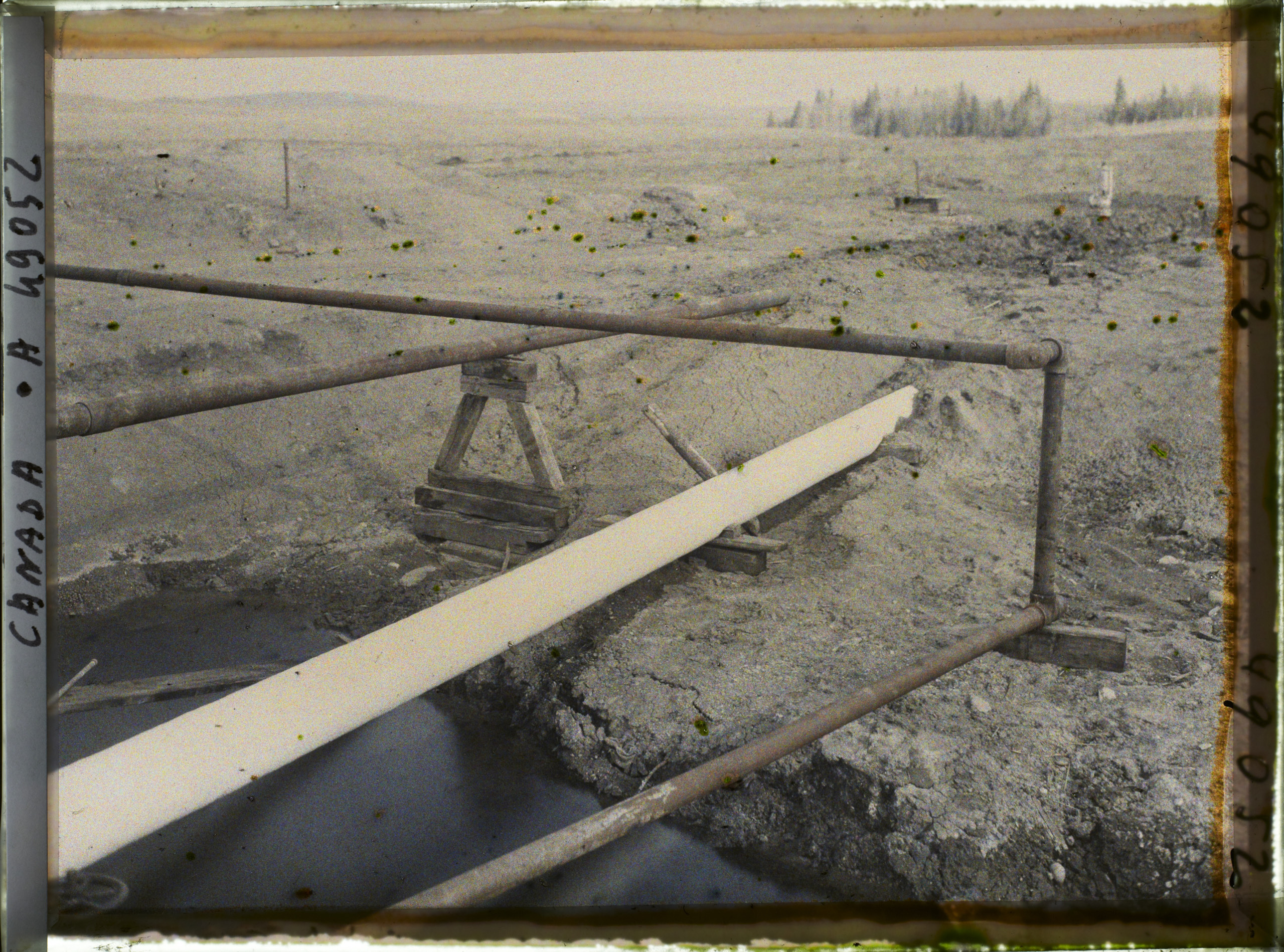
Episode visualWell outlet and natural-gas pipes at Royalite No.4, photographed in original autochrome colour by Frédéric Gadmer on 13 May 1926. Not AI colourization.Frédéric Gadmer / Département des Hauts-de-Seine, musée Albert-Kahn, A49052 · CC BY-SA 4.0 · Image record ↗ · Licence ↗Episode visualEquipment at Royalite No.4, photographed in original autochrome colour by Frédéric Gadmer on 13 May 1926. Not AI colourization.Frédéric Gadmer / Département des Hauts-de-Seine, musée Albert-Kahn, A49056 · CC BY-SA 4.0 · Image record ↗ · Licence ↗Episode visualSmith separator at Royalite No.4, photographed in original autochrome colour by Frédéric Gadmer on 13 May 1926. Not AI colourization.Frédéric Gadmer / Département des Hauts-de-Seine, musée Albert-Kahn, A49058 · CC BY-SA 4.0 · Image record ↗ · Licence ↗Episode visualAnother aspect of the soda-ash purification plant at Royalite No.4, photographed in original autochrome colour by Frédéric Gadmer on 13 May 1926. Not AI colourization.Frédéric Gadmer / Département des Hauts-de-Seine, musée Albert-Kahn, A49062 · CC BY-SA 4.0 · Image record ↗ · Licence ↗Episode visualThe gas outlet draws from the upper gas space, while liquid leaves below the liquid level. This physical separation does not itself sweeten sour gas. Two-phase separator function only; this is neither an engineering design nor an exact historical vessel.GeoNavigate Industry Chatter — original explanatory diagram · Original GeoNavigate production asset; source references concern the explanation, not ownership of the drawing. · Image record ↗
In May nineteen twenty-six, photographer Frédéric Gadmer documented Royalite Number Four on autochrome plates. The collection records several views of the installations, pipework, a Smith separator, purification equipment, and a flare burning surplus gas.
These images allow us to slow down. A valve wheel gives a sense of scale. Platforms and stairs show where workers needed access. Pipes connect the well area to equipment that had to keep operating after the drilling crew's central job was finished.
We can examine those visible features without pretending to know every internal flow path. A photograph does not reveal the design pressure stamped on a vessel, the position of a hidden valve, or the chemistry moving through a pipe at that instant.
The glass-plate edges, wear and subdued colours remain part of the source. The photographs have not been recoloured, reconstructed, or given invented moving machinery.
When the episode switches to a diagram, the change is explicit. The diagram explains a function. The photograph records an object. Keeping those two kinds of evidence separate gives us a much clearer view of how the field actually worked.
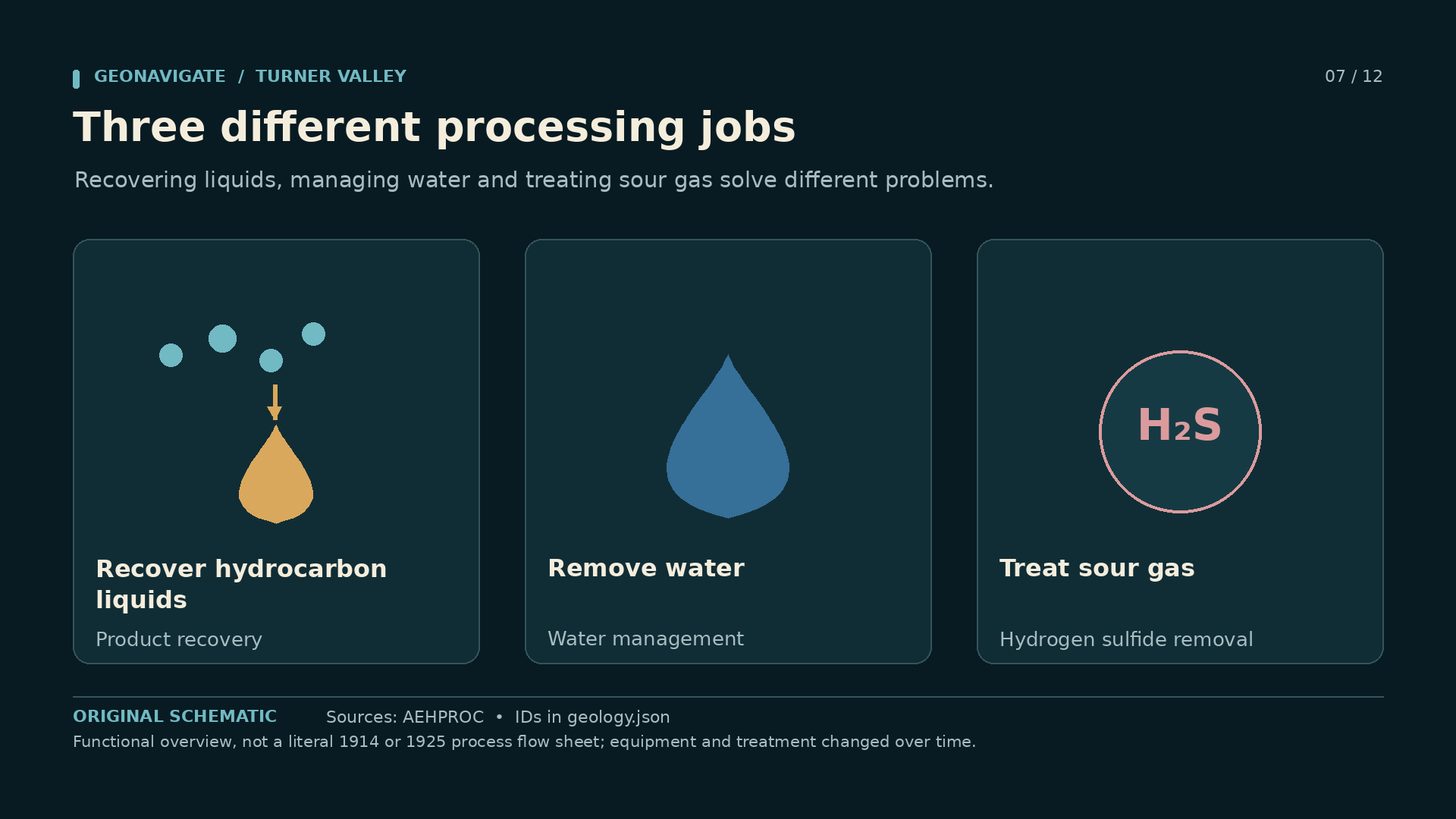
Episode visualEquipment at Royalite No.4, photographed in original autochrome colour by Frédéric Gadmer on 13 May 1926. Not AI colourization.Frédéric Gadmer / Département des Hauts-de-Seine, musée Albert-Kahn, A49056 · CC BY-SA 4.0 · Image record ↗ · Licence ↗Episode visualSmith separator at Royalite No.4, photographed in original autochrome colour by Frédéric Gadmer on 13 May 1926. Not AI colourization.Frédéric Gadmer / Département des Hauts-de-Seine, musée Albert-Kahn, A49058 · CC BY-SA 4.0 · Image record ↗ · Licence ↗Episode visualSoda-ash purification plant at Royalite No.4, photographed in original autochrome colour by Frédéric Gadmer on 13 May 1926. Not AI colourization.Frédéric Gadmer / Département des Hauts-de-Seine, musée Albert-Kahn, A49060 · CC BY-SA 4.0 · Image record ↗ · Licence ↗Episode visualAnother aspect of the soda-ash purification plant at Royalite No.4, photographed in original autochrome colour by Frédéric Gadmer on 13 May 1926. Not AI colourization.Frédéric Gadmer / Département des Hauts-de-Seine, musée Albert-Kahn, A49062 · CC BY-SA 4.0 · Image record ↗ · Licence ↗Episode visualHydrocarbon-liquid recovery, water removal and hydrogen-sulfide treatment are separate processing functions. The three cards do not claim a historical sequence. Functional overview, not a literal 1914 or 1925 process flow sheet; equipment and treatment changed over time.GeoNavigate Industry Chatter — original explanatory diagram · Original GeoNavigate production asset; source references concern the explanation, not ownership of the drawing. · Image record ↗
Royalite's deeper gas brought another problem: hydrogen sulfide. Its toxicity and corrosive behaviour made treatment essential. The commercial value of the hydrocarbon stream did not cancel the hazards mixed into it.
At Turner Valley, Samuel Coultis helped develop the processing response. A sweetening installation using soda ash began operating in the nineteen twenties. Soda ash is sodium carbonate. Later equipment and processes changed as the plant expanded.
Liquid recovery and gas sweetening served different purposes. Recovering natural gasoline captured valuable heavier hydrocarbons. Sweetening reduced hydrogen sulfide. Water handling was another requirement. A general process diagram can separate those jobs without claiming that every vessel followed one unchanged sequence throughout the plant's history.
Royalite also developed high-pressure absorption facilities for recovering natural gasoline. The plant became a place where engineering knowledge, operating experience and commercial decisions accumulated together.
That is why the machinery deserves more than a background shot. A discovery had to become a dependable stream of useful products. The separator, the treatment vessels, the compressors and the pipeline were part of that transformation. Companies able to finance and operate those systems had an advantage that extended well beyond the geology of any single lease.
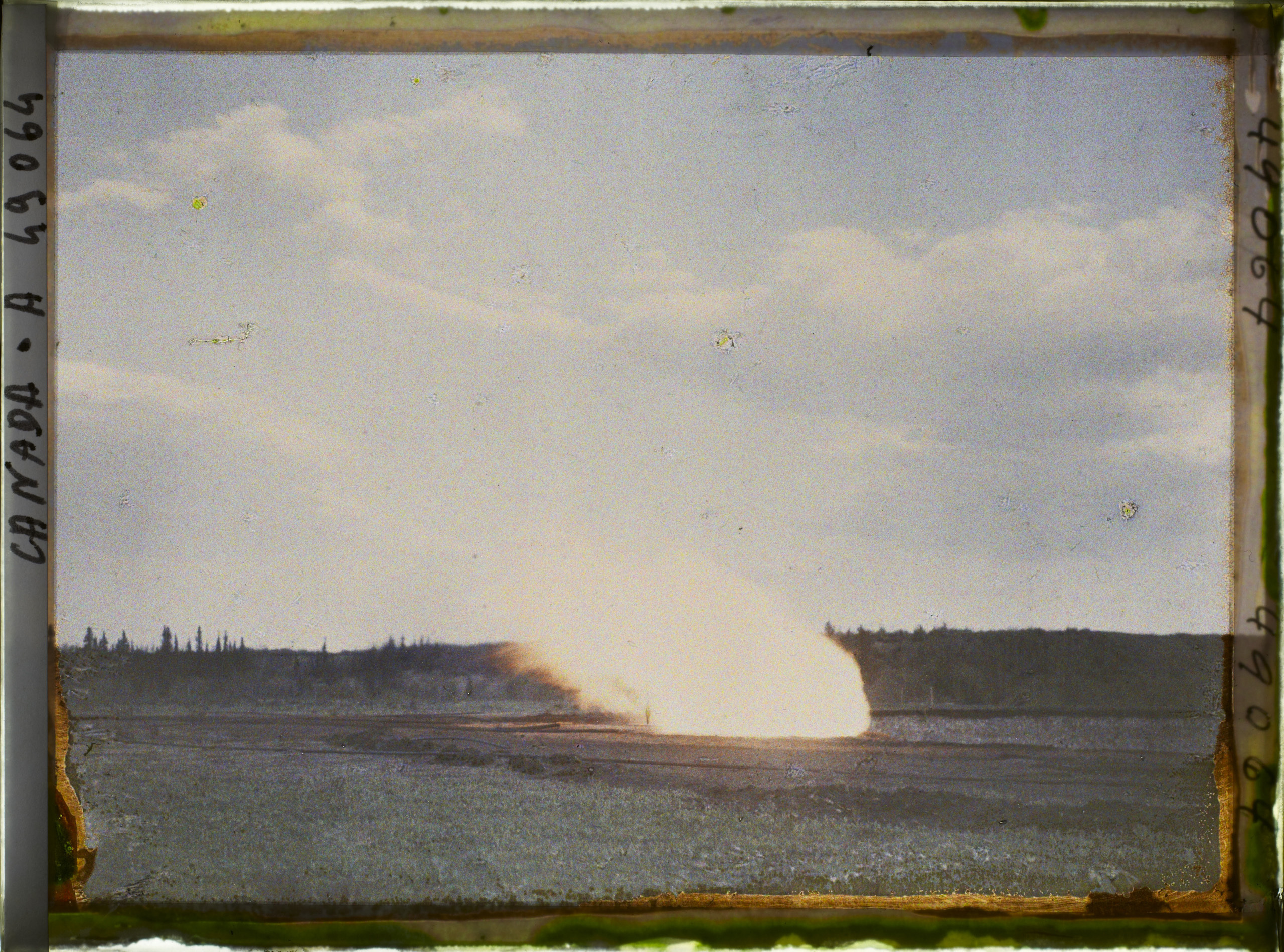
Source imageAn oil well in Turner Valley, circa 1940; the archive does not identify the well.Provincial Archives of Alberta, P1765 · No known copyright restrictions — official institution on Flickr Commons · Image record ↗ · Licence ↗Episode visualExcess-gas flare at Royalite No.4, photographed in original autochrome colour by Frédéric Gadmer on 13 May 1926. Not AI colourization.Frédéric Gadmer / Département des Hauts-de-Seine, musée Albert-Kahn, A49064 · CC BY-SA 4.0 · Image record ↗ · Licence ↗Episode visualReservoir gas can provide expansion energy for oil production. Excess gas withdrawal can spend useful energy. Arrow widths are qualitative symbols, not production rates. Concept of reservoir energy, not a Turner Valley simulation, pressure measurement or quantified oil-loss estimate.GeoNavigate Industry Chatter — original explanatory diagram · Original GeoNavigate production asset; source references concern the explanation, not ownership of the drawing. · Image record ↗Conceptual diagramA simplified gas/oil/water arrangement is shown inside reservoir rock, with a pore-space inset. Real Turner Valley structure, contacts and connectivity are more complex. Conceptual connected trap, not an actual Turner Valley section; contacts, geometry and scale are illustrative.GeoNavigate Industry Chatter — original explanatory diagram · Original GeoNavigate production asset; source references concern the explanation, not ownership of the drawing. · Image record ↗
One of Gadmer's photographs records a flare burning gas that the operation did not use. Other historical photographs show how thoroughly flares became part of Turner Valley's landscape.
The economics could favour recovering valuable liquids while leaving more gas than local markets and transport could absorb. The flame made the surplus visible. It also represented petroleum that would no longer be available for another use.
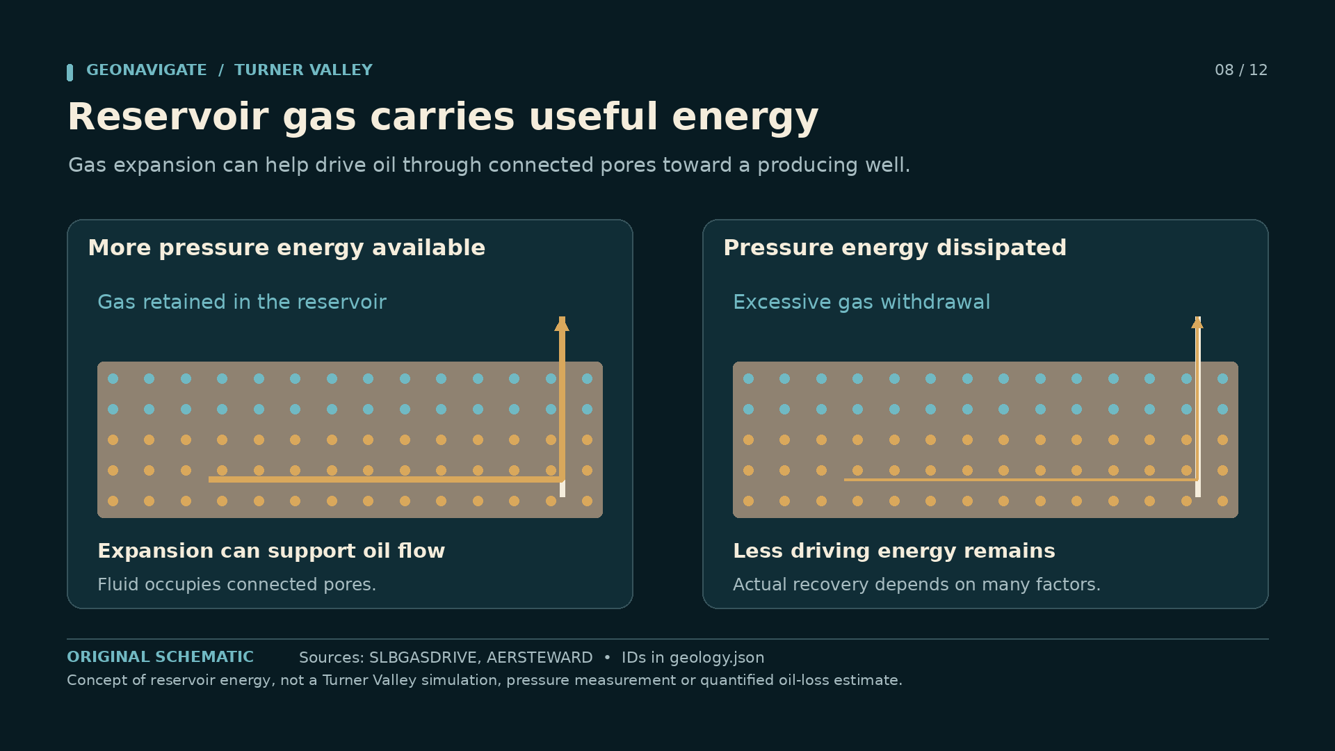
There was a reservoir consequence as well. In a connected gas-and-oil system, withdrawing gas changes pressure and can change the energy available to move oil toward wells. The size of that effect depends on the actual reservoir, its connectivity, production history and other sources of pressure support.
A simple gas-cap diagram helps explain the mechanism. It cannot tell us exactly how many barrels were lost at Turner Valley, and it must not imply that every well and every producing interval shared one perfectly connected tank.
Conservation therefore became more than an argument about a conspicuous flame. It concerned the way many separate operators were drawing from a petroleum resource whose behaviour crossed lease lines. Producing the most attractive stream today could make the remaining resource harder to recover tomorrow.
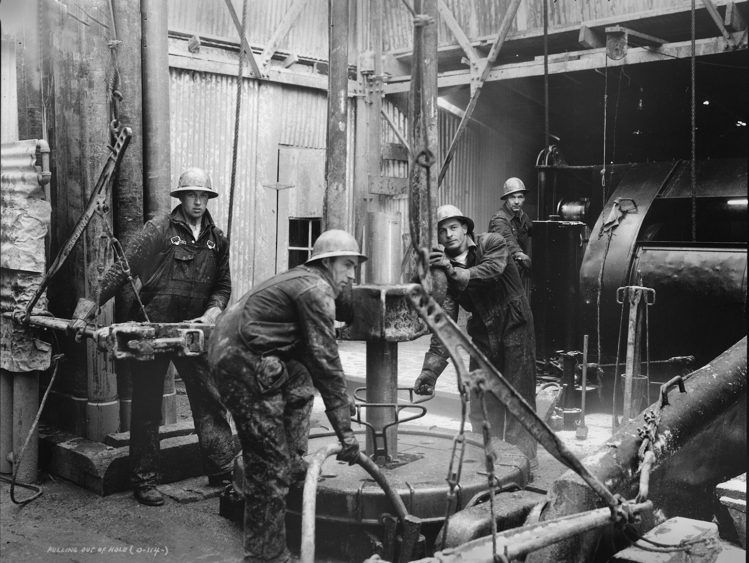
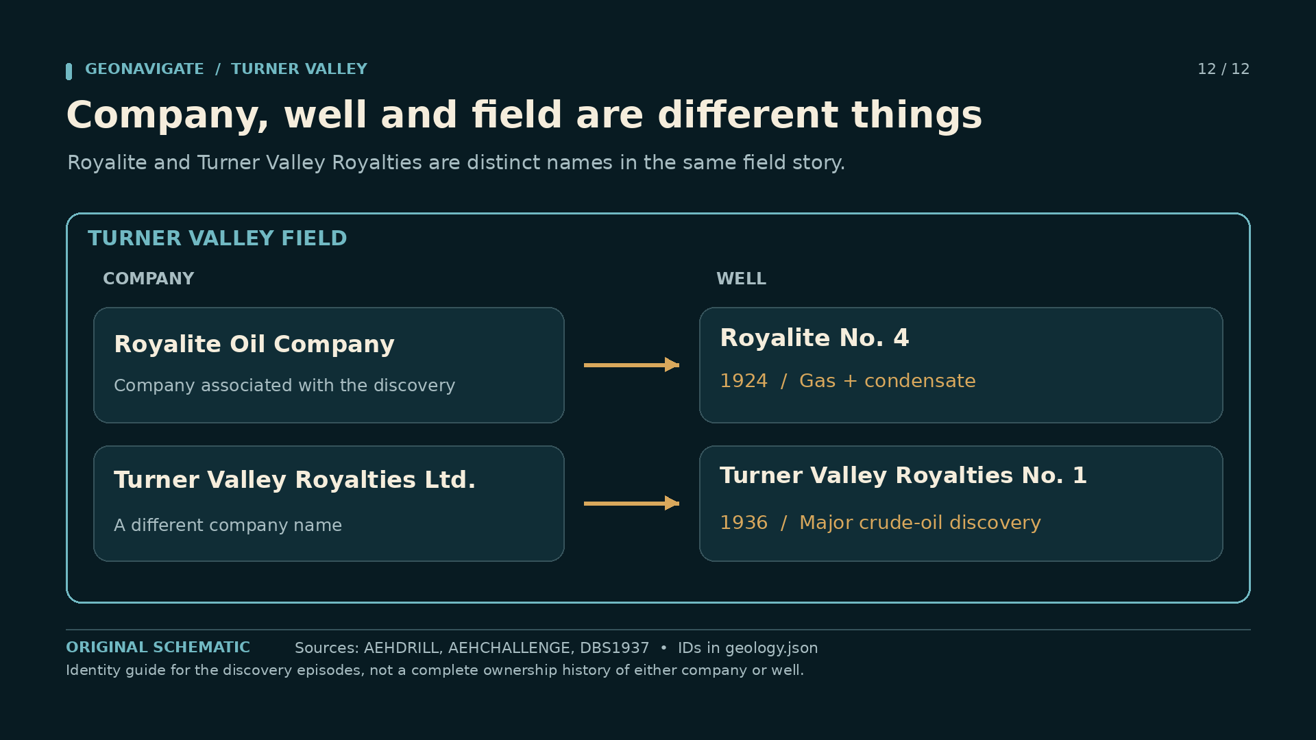
Episode visualPulling out of a drill hole in Turner Valley, circa 1940; later field-development context.Provincial Archives of Alberta, P1983 · No known copyright restrictions — official institution on Flickr Commons · Image record ↗ · Licence ↗Episode visualWorkers assemble derrick base. Turner Valley field-development context, published Summer 1938. Exact capture date is unstated; this is not identified as the 1936 discovery well.Imperial Oil Review, Summer 1938, p. 3, figure 4; photographer uncredited. Scan: Alberta’s Energy Heritage. · Public domain in Canada — historical-photograph inference; no worldwide licence asserted · Image record ↗ · Rights basis ↗Episode visualTurner Valley Royalties No. 1 as a gusher in 1936; the official heritage caption identifies the June 16 discovery. The separate shutter date has not been verified.Glenbow Archives, NA-2335-2; reproduced on Alberta’s Energy Heritage. · Public domain in Canada — historical-photograph inference; no worldwide licence asserted · Image record ↗ · Rights basis ↗Episode visual1914 sandstone gas and light liquids, 1924 deep carbonate gas and condensate, and 1936 major crude-oil development mark different chapters. Selected turning points in a longer field history; these were not the only discoveries.GeoNavigate Industry Chatter — original explanatory diagram · Original GeoNavigate production asset; source references concern the explanation, not ownership of the drawing. · Image record ↗Episode visualRoyalite Oil Company and Turner Valley Royalties Ltd. are distinct corporate names. Their named discovery wells belong to the broader Turner Valley field story. Identity guide for the discovery episodes, not a complete ownership history of either company or well.GeoNavigate Industry Chatter — original explanatory diagram · Original GeoNavigate production asset; source references concern the explanation, not ownership of the drawing. · Image record ↗
Turner Valley had produced liquid petroleum for years, and earlier wells had encountered crude oil. The nineteen thirty-six discovery was not the first appearance of oil molecules in the valley.
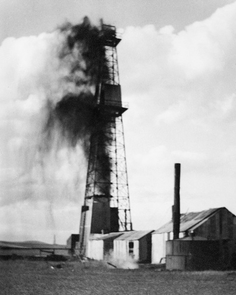
Its importance was the scale of development it opened. On June sixteenth, Turner Valley Royalties Number One came in near the southern part of the field. The success helped launch the major crude-oil phase of Turner Valley's history.
Robert Arthur Brown had pursued the idea of a substantial oil accumulation associated with the field. He did not do it entirely alone. Accounts describe financial and equipment support involving Imperial Oil and British American Oil. The result depended on investors, a drilling crew, equipment and a test in the ground.
The company name needs special attention. Turner Valley Royalties was a different company from Royalite. Similar names do not make their wells or ownership interchangeable.
For people looking for work during the Depression, the discovery mattered immediately. More drilling meant more demand for crews, services, accommodation and transport. For geologists, it expanded the practical meaning of a field that had already been productive for more than twenty years. Turner Valley was being understood again through a different part of its petroleum system.
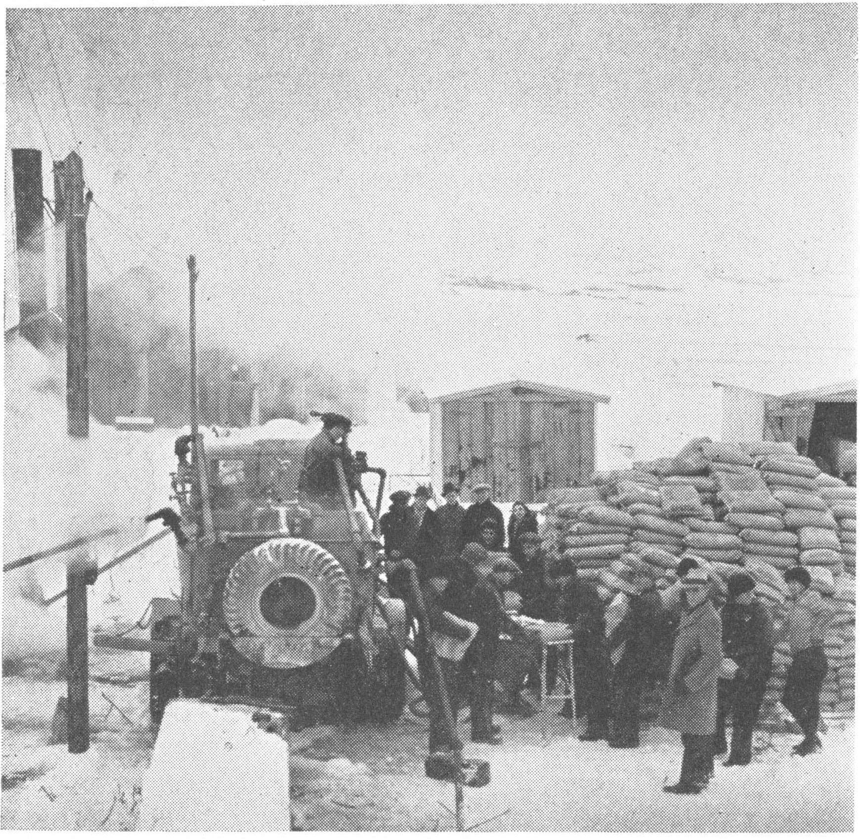
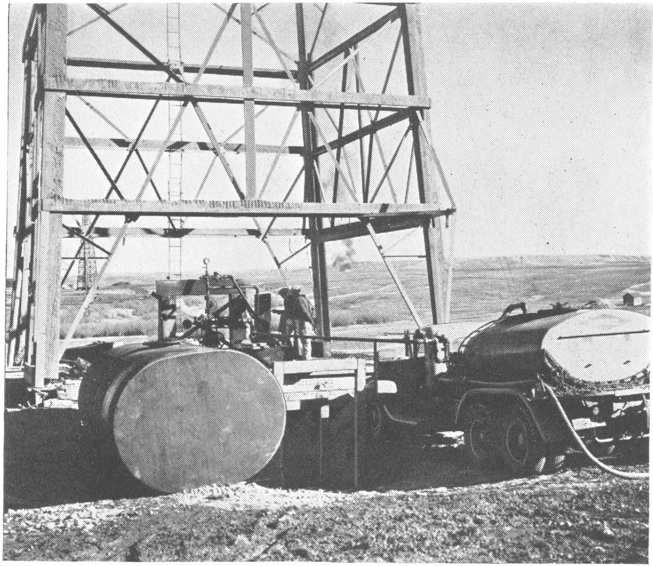
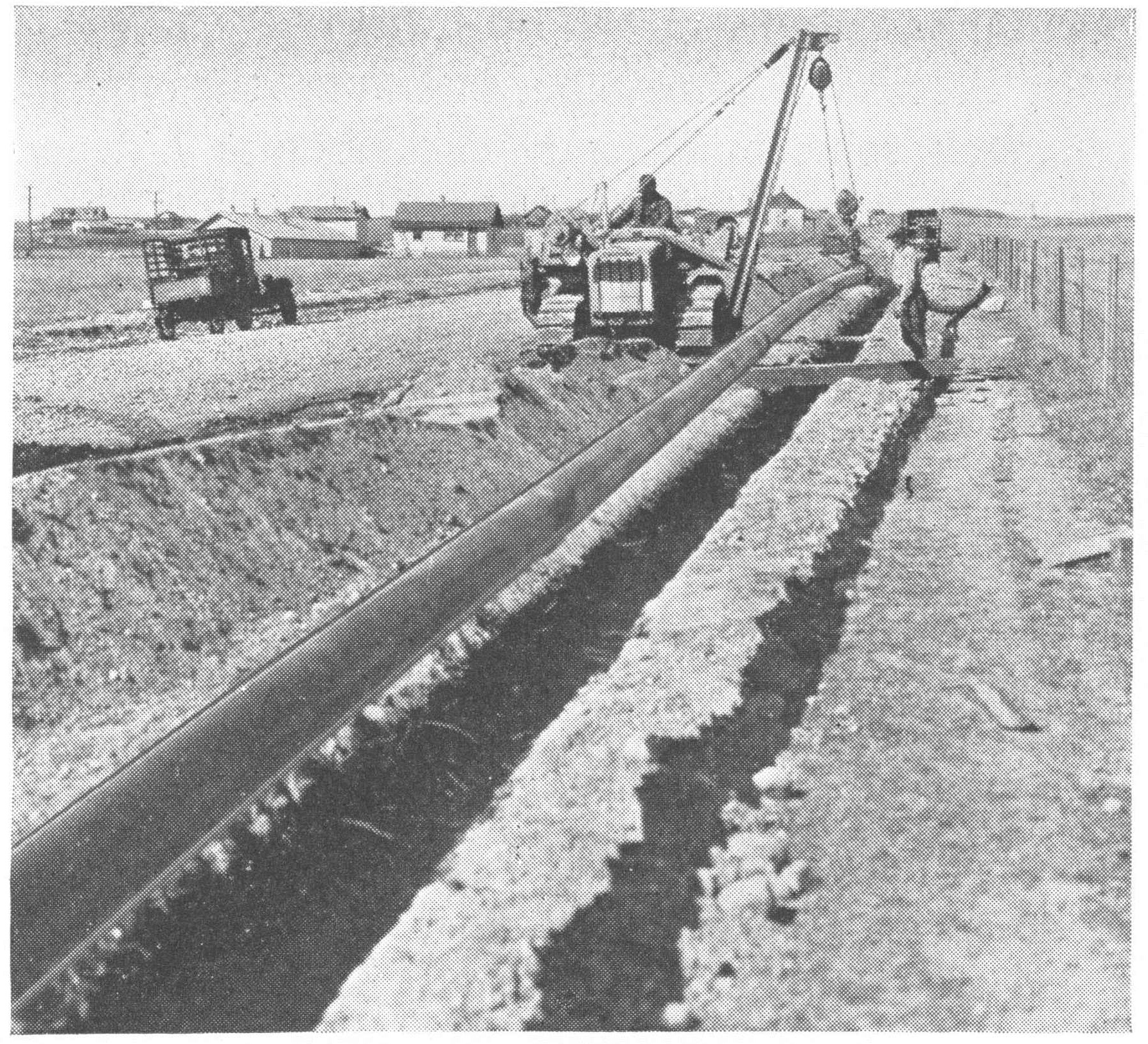
Episode visualCement and equipment surround crew. Turner Valley field-development context, published Summer 1938. Exact capture date is unstated; this is not identified as the 1936 discovery well.Imperial Oil Review, Summer 1938, p. 6, figure 16; photographer uncredited. Scan: Alberta’s Energy Heritage. · Public domain in Canada — historical-photograph inference; no worldwide licence asserted · Image record ↗ · Rights basis ↗Episode visualTank trucks deliver acid. Turner Valley field-development context, published Summer 1938. Exact capture date is unstated; this is not identified as the 1936 discovery well.Imperial Oil Review, Summer 1938, p. 7, figure 18; photographer uncredited. Scan: Alberta’s Energy Heritage. · Public domain in Canada — historical-photograph inference; no worldwide licence asserted · Image record ↗ · Rights basis ↗Episode visualPipeline laid toward Calgary. Turner Valley field-development context, published Summer 1938. Exact capture date is unstated; this is not identified as the 1936 discovery well.Imperial Oil Review, Summer 1938, p. 7, figure 21; photographer uncredited. Scan: Alberta’s Energy Heritage. · Public domain in Canada — historical-photograph inference; no worldwide licence asserted · Image record ↗ · Rights basis ↗Conceptual diagramA simplified gas/oil/water arrangement is shown inside reservoir rock, with a pore-space inset. Real Turner Valley structure, contacts and connectivity are more complex. Conceptual connected trap, not an actual Turner Valley section; contacts, geometry and scale are illustrative.GeoNavigate Industry Chatter — original explanatory diagram · Original GeoNavigate production asset; source references concern the explanation, not ownership of the drawing. · Image record ↗Episode visualThe literature describes evolving interpretations, from mapped anticlines through thrust-related structures to triangle-zone and faulted-stack models. These cartoons do not reconstruct exact field geometry. Illustrative model families, not reproductions of published cross-sections or the exact geometry of Turner Valley.GeoNavigate Industry Chatter — original explanatory diagram · Original GeoNavigate production asset; source references concern the explanation, not ownership of the drawing. · Image record ↗
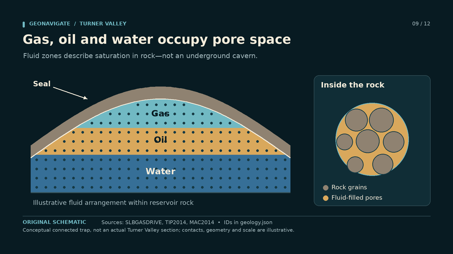
Imagine a connected reservoir containing a gas cap above an oil zone, with water below. The fluids occupy pore space within rock. They are not stacked in a vast empty cavern beneath the field.
That picture explains a possibility, not a surveyed cross-section of Turner Valley. Real contacts, fault relationships and reservoir connections must be established from wells and other evidence. A producing gas well near the crest does not, on its own, map the oil-bearing rock farther down the structure.
An oil discovery therefore changes the next drilling questions. How far does the productive interval extend? Which parts of the carbonate have useful storage and permeability? Where are the contacts? What rate can a well sustain, and what happens as pressure changes?
Production also has to leave the field. Pipeline capacity expanded during the late nineteen thirties as the crude-oil business grew. A barrel measured at the wellhead was only part of the journey to a refinery and a market.
The dramatic discovery date is easy to remember. Appraisal is slower. It turns an exciting result from one well into a defensible understanding of an accumulation. That is the work that lets a discovery become a producing field.
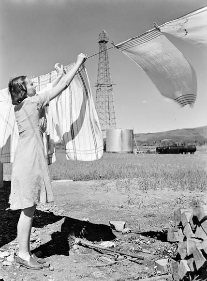
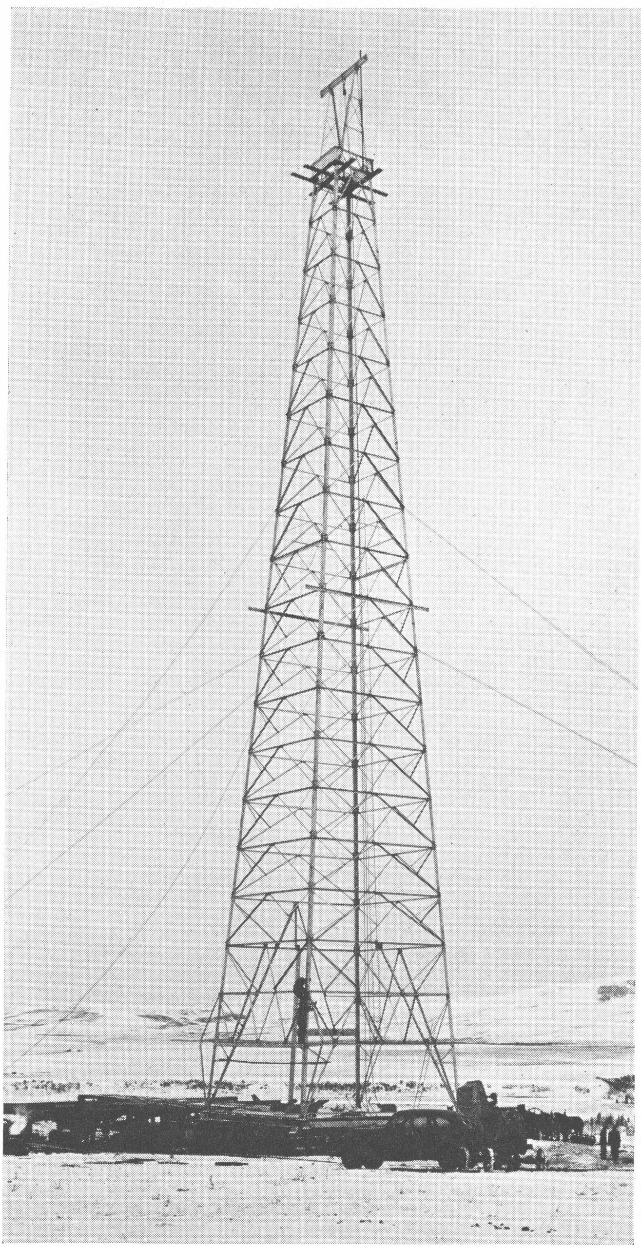
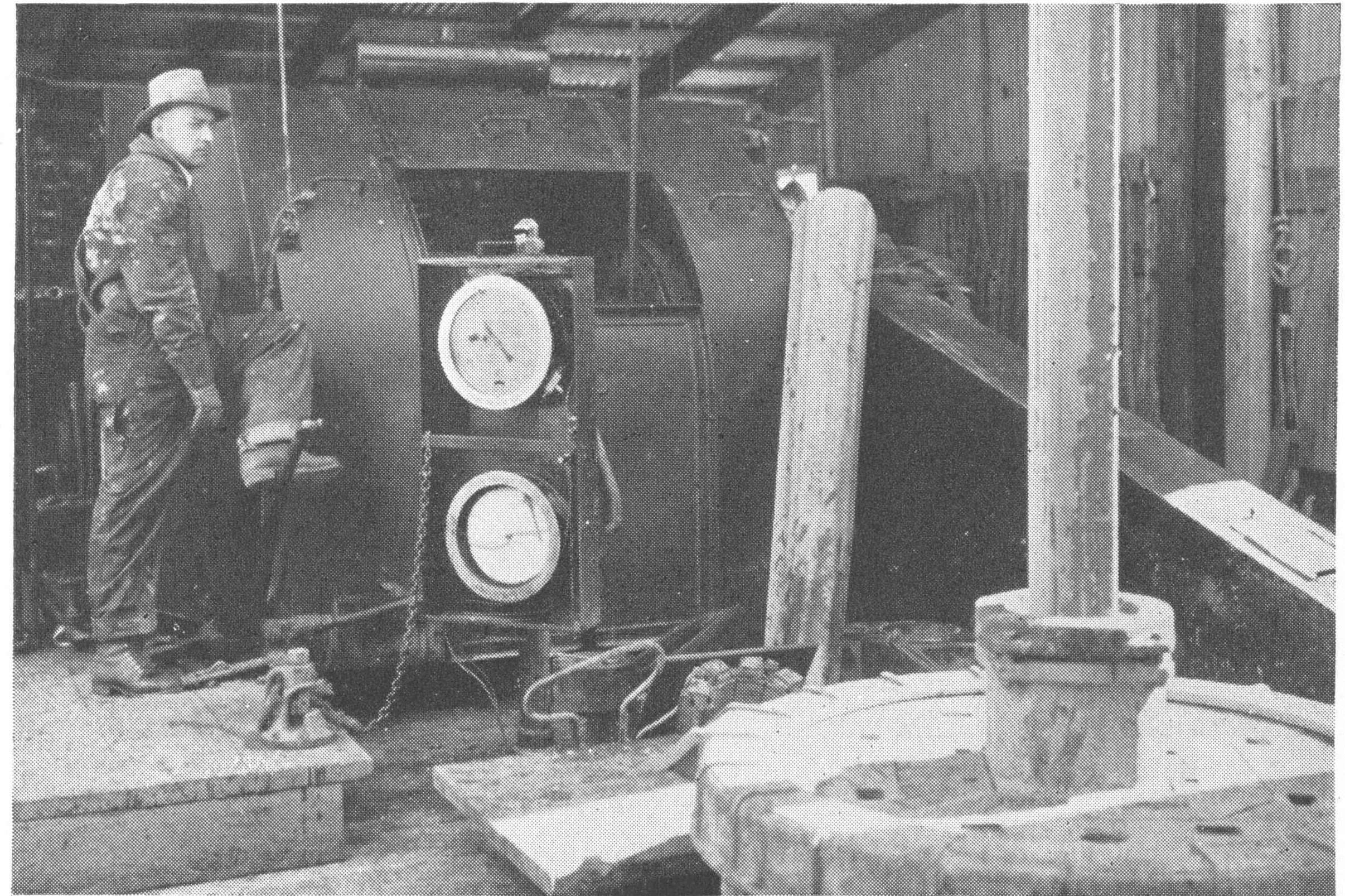
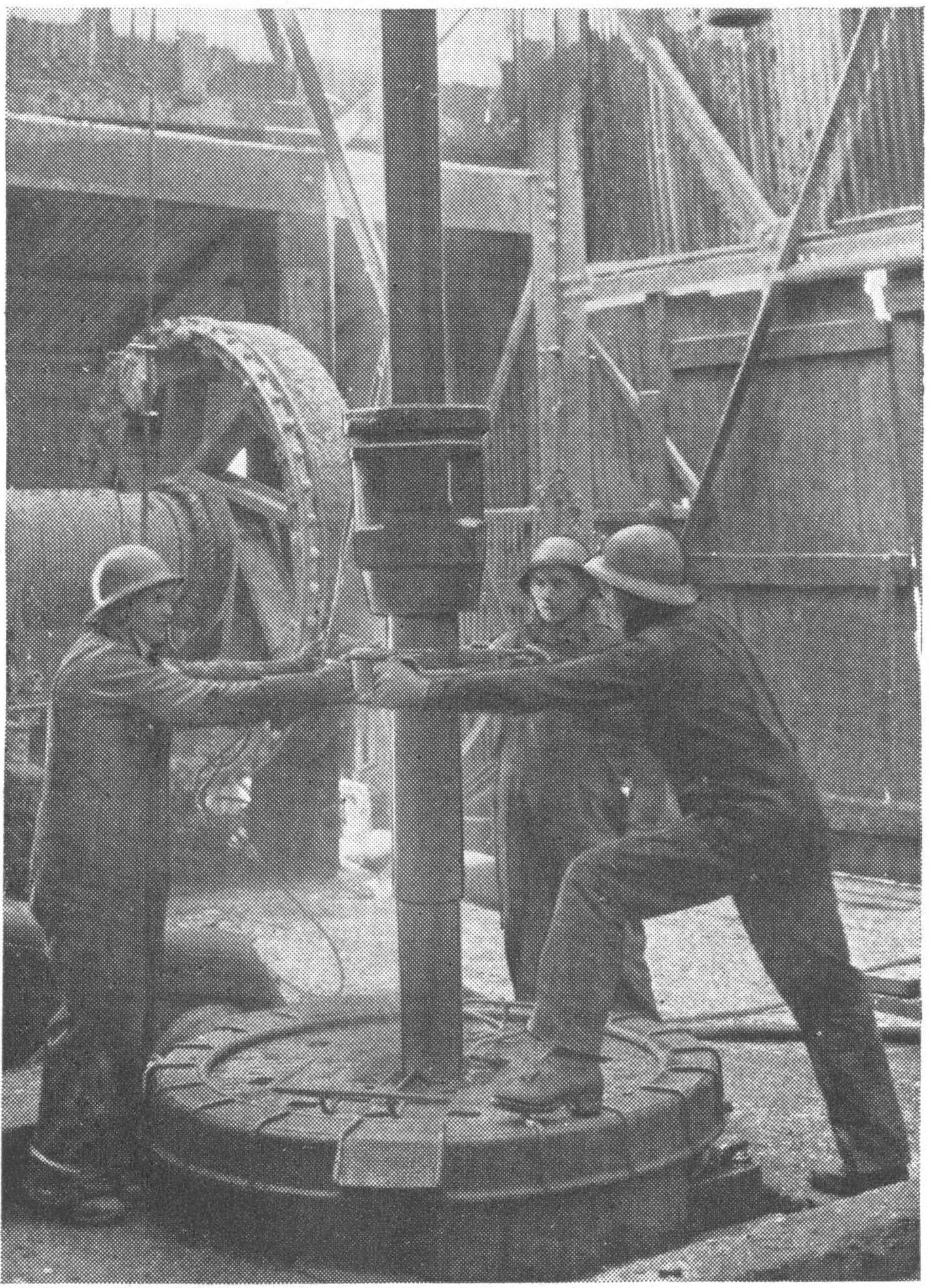
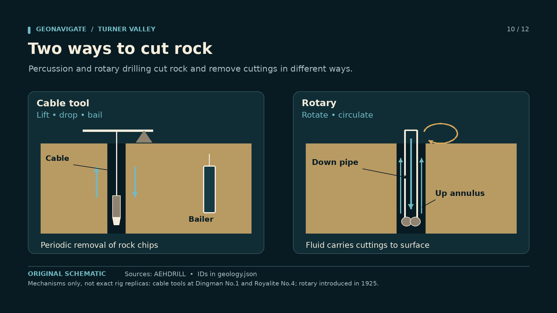
Episode visualMrs. Don Carr hangs washing with an oil derrick behind her in Turner Valley, June 1945. Photograph by Ronny Duke.Ronny Duke / National Film Board of Canada / Library and Archives Canada, PA-184544 · CC BY 2.0 — official Library and Archives Canada Flickr · Image record ↗ · Licence ↗Episode visualCompleted derrick awaits crown block. Turner Valley field-development context, published Summer 1938. Exact capture date is unstated; this is not identified as the 1936 discovery well.Imperial Oil Review, Summer 1938, p. 3, figure 5b; photographer uncredited. Scan: Alberta’s Energy Heritage. · Public domain in Canada — historical-photograph inference; no worldwide licence asserted · Image record ↗ · Rights basis ↗Episode visualDriller operates gauges and draw-works. Turner Valley field-development context, published Summer 1938. Exact capture date is unstated; this is not identified as the 1936 discovery well.Imperial Oil Review, Summer 1938, p. 5, figure 10; photographer uncredited. Scan: Alberta’s Energy Heritage. · Public domain in Canada — historical-photograph inference; no worldwide licence asserted · Image record ↗ · Rights basis ↗Episode visualCrew couples drill stem. Turner Valley field-development context, published Summer 1938. Exact capture date is unstated; this is not identified as the 1936 discovery well.Imperial Oil Review, Summer 1938, p. 5, figure 11; photographer uncredited. Scan: Alberta’s Energy Heritage. · Public domain in Canada — historical-photograph inference; no worldwide licence asserted · Image record ↗ · Rights basis ↗Episode visualCable tools repeatedly lift and drop a heavy bit, with cuttings removed by bailing. Rotary drilling turns a bit and circulates fluid down the pipe and back up the annulus. Mechanisms only, not exact rig replicas: cable tools at Dingman No.1 and Royalite No.4; rotary introduced in 1925.GeoNavigate Industry Chatter — original explanatory diagram · Original GeoNavigate production asset; source references concern the explanation, not ownership of the drawing. · Image record ↗
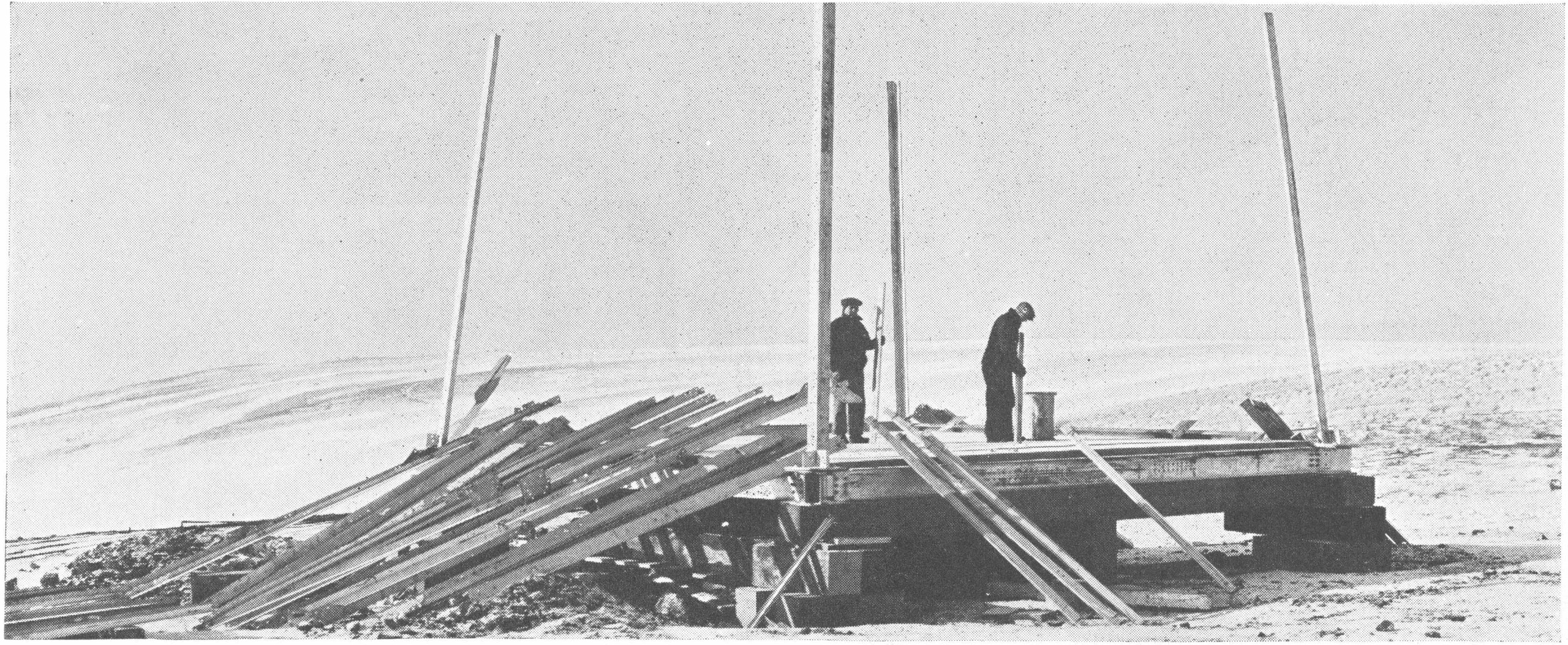
A nineteen thirty-eight photographic essay follows the construction and operation of a Turner Valley well. It begins with work on the location and the derrick, then brings us closer to the machinery and the crew.
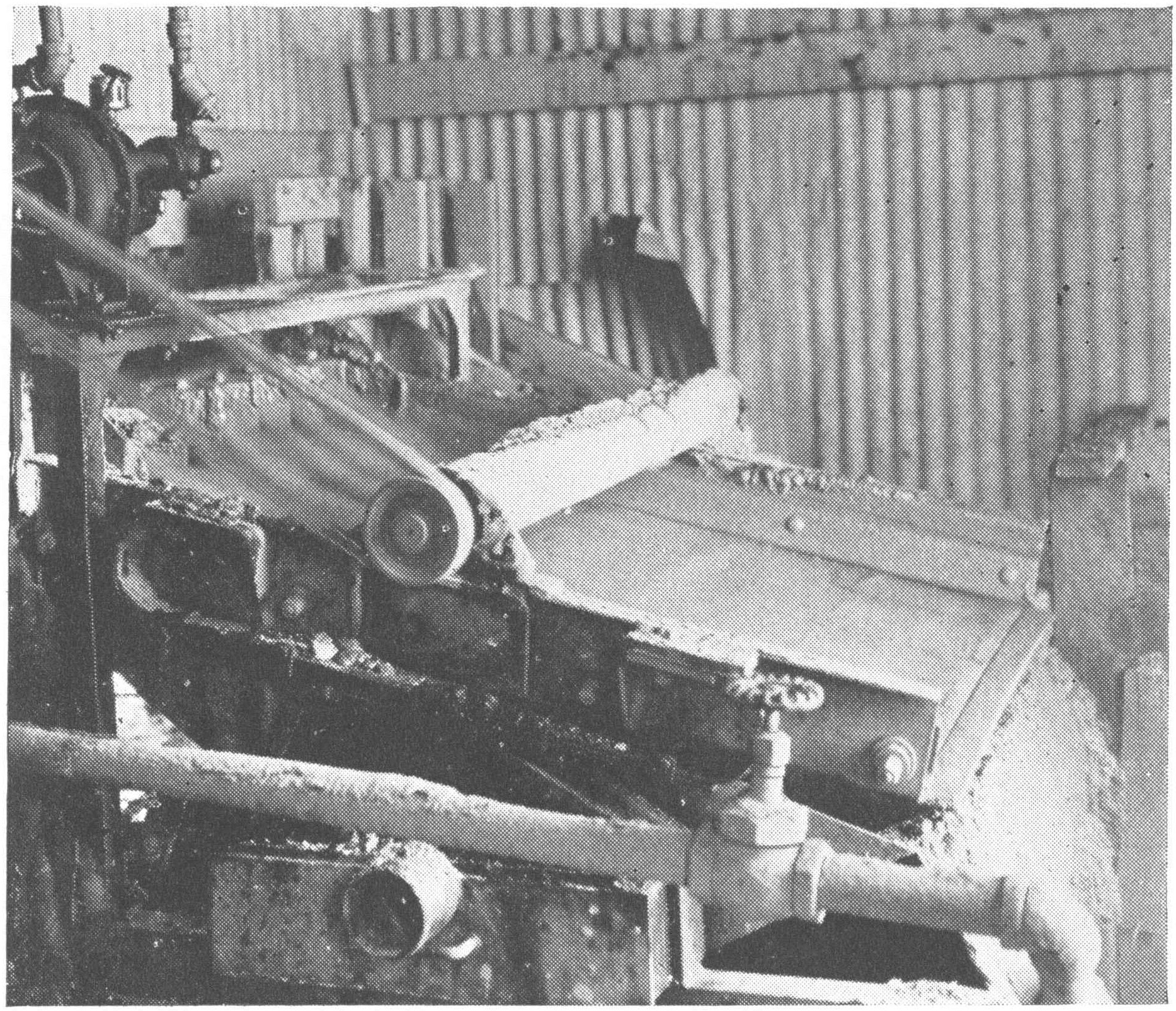
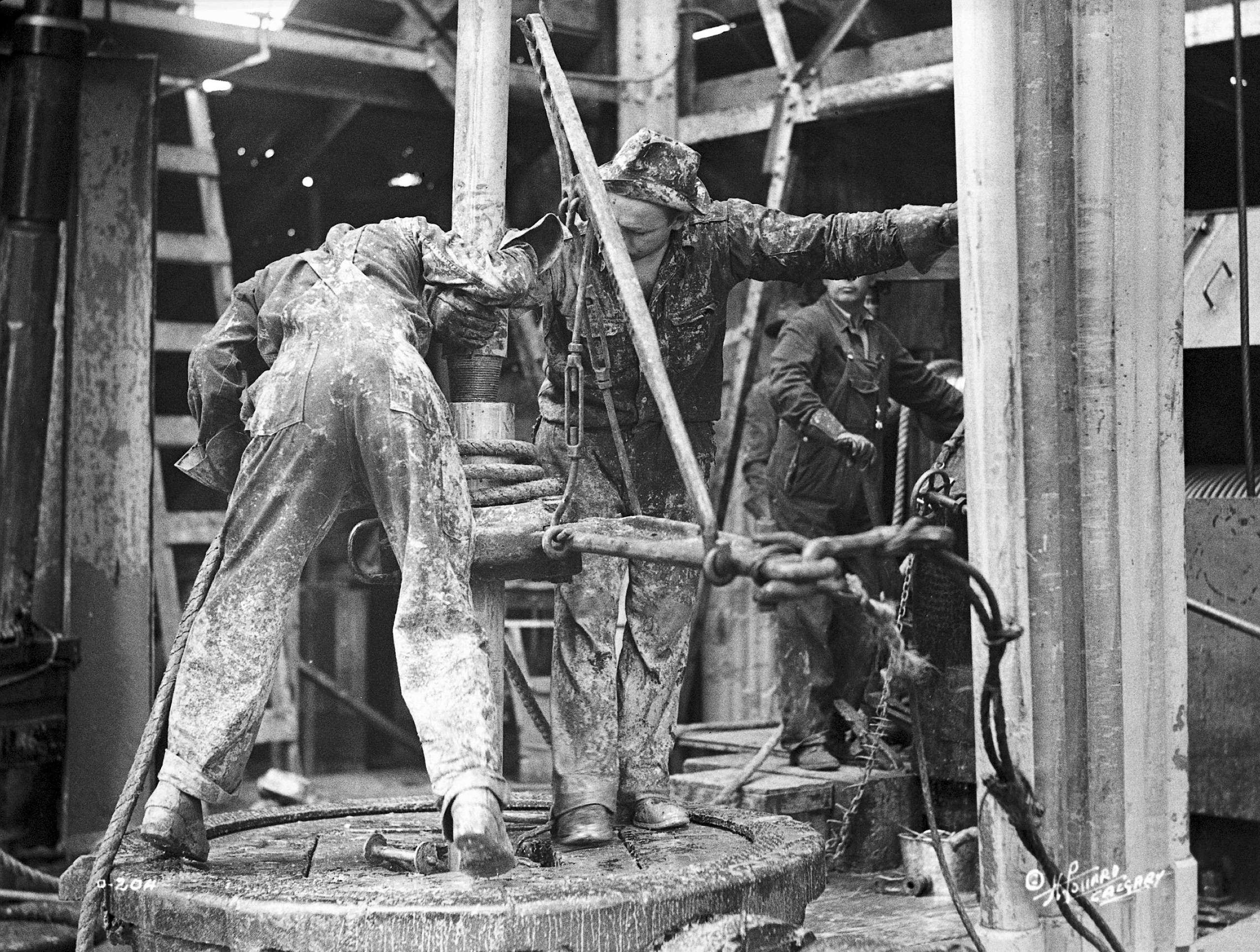
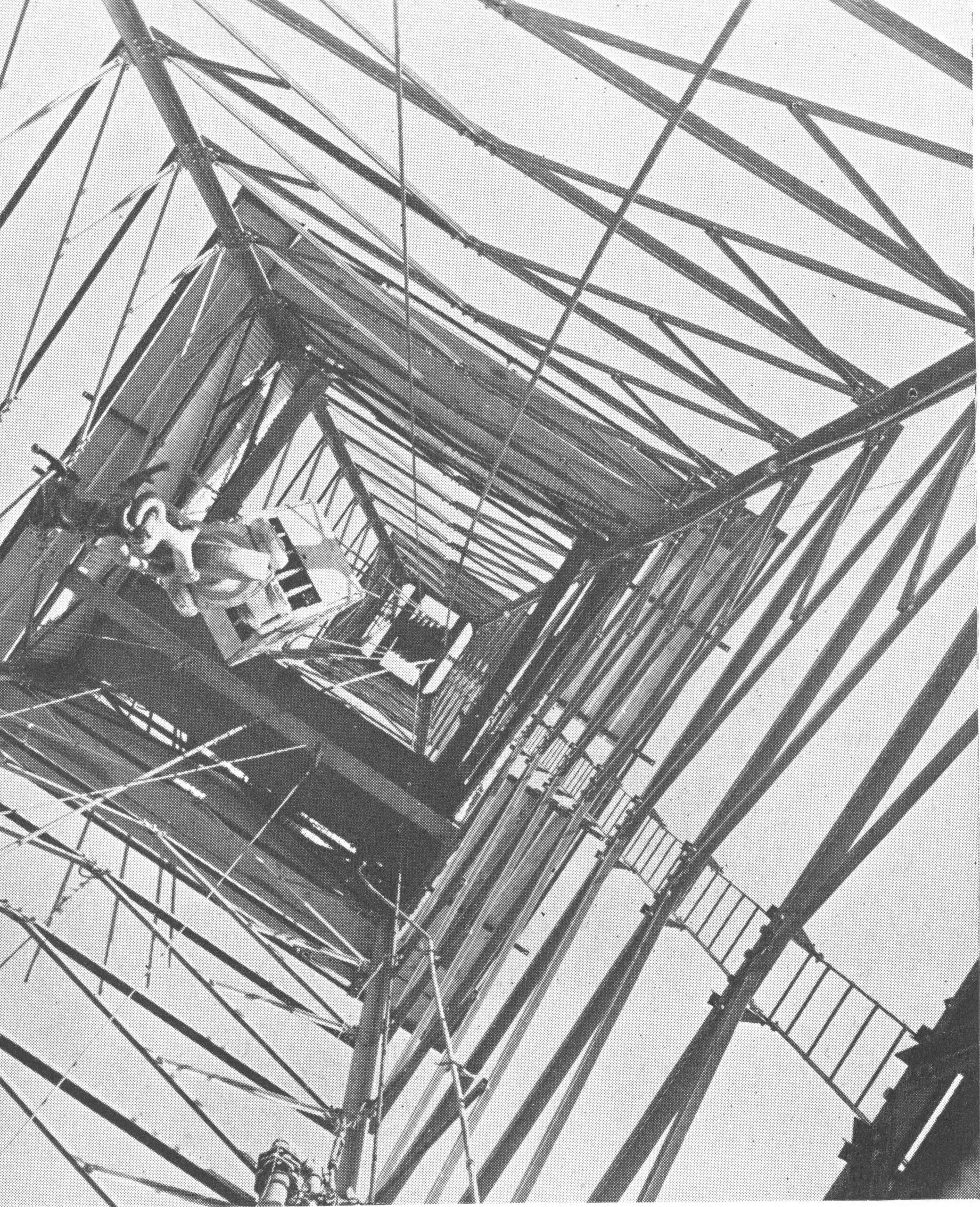
The photographs include hoisting equipment, boilers and pumps, drawworks, men working with tongs, mud-handling equipment, cementing and production facilities. These are development scenes from the field. The essay does not establish that every photograph shows the nineteen thirty-six discovery well.
Each view makes a different piece of work visible. Hoisting equipment handles the drill string. The drilling system turns mechanical energy into progress through rock. Circulating fluid carries cuttings, while casing and cement help form the completed well's barriers and support.
No single photograph shows all those functions operating together. Seen as a sequence, however, they reveal how many people and systems stood behind the word discovery.
The wider community changed with the work. Boarding houses, shops and services grew around renewed drilling. Families experienced the uncertainty of the field through wages, employment and whether a settlement would last. A successful company could report production in barrels. The people who lived there measured success in more immediate ways.
Episode visualPulling out of a drill hole in Turner Valley, circa 1940; later field-development context.Provincial Archives of Alberta, P1983 · No known copyright restrictions — official institution on Flickr Commons · Image record ↗ · Licence ↗Episode visualShaker removes drilling debris. Turner Valley field-development context, published Summer 1938. Exact capture date is unstated; this is not identified as the 1936 discovery well.Imperial Oil Review, Summer 1938, p. 6, figure 15; photographer uncredited. Scan: Alberta’s Energy Heritage. · Public domain in Canada — historical-photograph inference; no worldwide licence asserted · Image record ↗ · Rights basis ↗Episode visualThe literature describes evolving interpretations, from mapped anticlines through thrust-related structures to triangle-zone and faulted-stack models. These cartoons do not reconstruct exact field geometry. Illustrative model families, not reproductions of published cross-sections or the exact geometry of Turner Valley.GeoNavigate Industry Chatter — original explanatory diagram · Original GeoNavigate production asset; source references concern the explanation, not ownership of the drawing. · Image record ↗
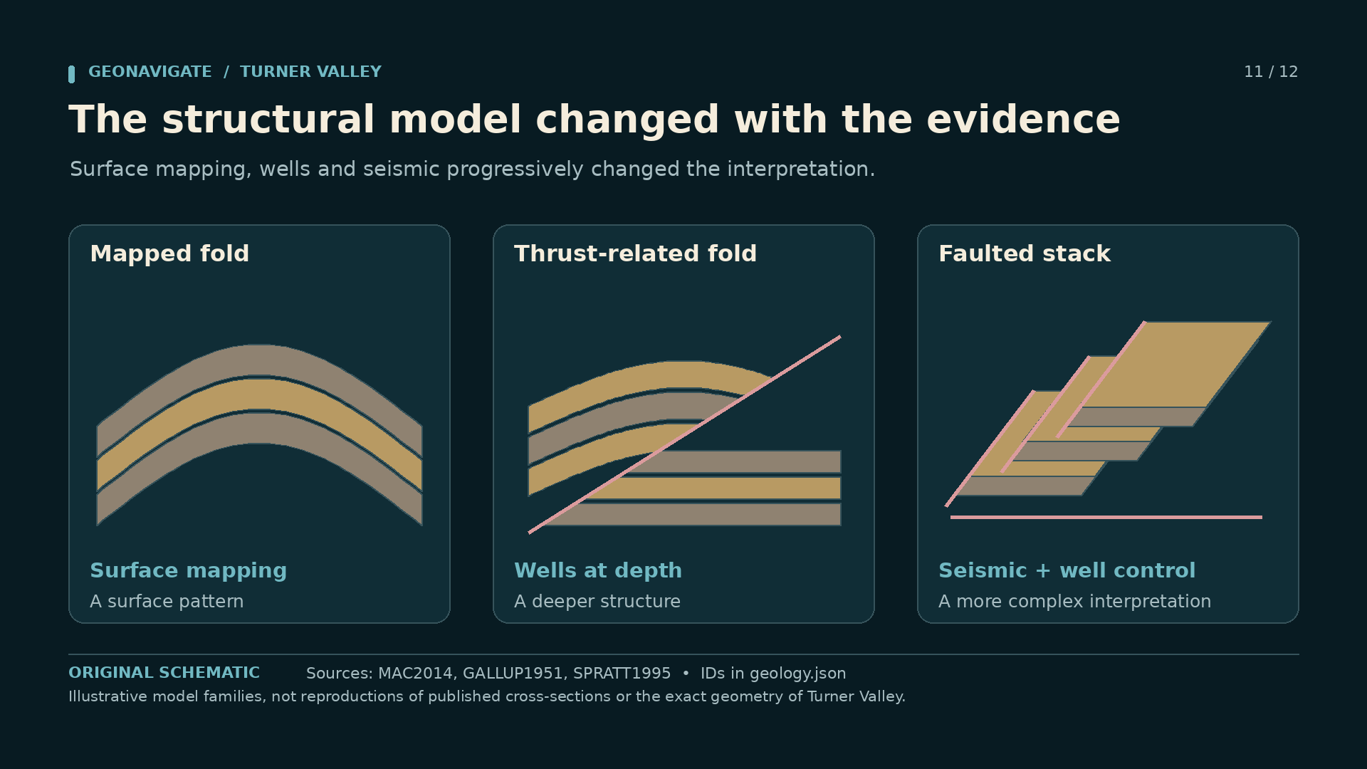
The surface rocks suggested a fold. Early maps gave explorers an anticline to investigate: strata arching upward through the foothills landscape. But a surface fold was not a complete picture of the structure at drilling depth.
As wells and later seismic information accumulated, geologists revised their interpretations. Turner Valley became important to the study of thrust faults, hanging-wall folds, structural wedges and faulted stacks of rock.
Those changes matter because faulting can repeat layers, shift their apparent position, and complicate the path from a surface observation to a subsurface target. Two similar rock intervals in a well are not automatically two different depositional packages. Structure may be part of the explanation.
Our drawings show successive ways of thinking about a folded and faulted system. They are conceptual comparisons, not a claim to reproduce every fault beneath Turner Valley. Exact geometry belongs to the interpreted geological section and its supporting evidence.
For anyone working on a well today, the lesson is familiar. A model earns confidence by explaining observations and surviving new tests. When the drill, the logs or the seismic disagree with it, the useful response is to improve the model. Turner Valley supplied generations of evidence for that process.
Episode visualOperations on a Turner Valley drilling floor, circa 1930; not identified as any of the three discovery wells.Provincial Archives of Alberta, P1233 · No known copyright restrictions — official institution on Flickr Commons · Image record ↗ · Licence ↗Episode visualExcess-gas flare at Royalite No.4, photographed in original autochrome colour by Frédéric Gadmer on 13 May 1926. Not AI colourization.Frédéric Gadmer / Département des Hauts-de-Seine, musée Albert-Kahn, A49064 · CC BY-SA 4.0 · Image record ↗ · Licence ↗Episode visualCrown/travelling blocks viewed from below. Turner Valley field-development context, published Summer 1938. Exact capture date is unstated; this is not identified as the 1936 discovery well.Imperial Oil Review, Summer 1938, p. 4, figure 7; photographer uncredited. Scan: Alberta’s Energy Heritage. · Public domain in Canada — historical-photograph inference; no worldwide licence asserted · Image record ↗ · Rights basis ↗Episode visual1914 sandstone gas and light liquids, 1924 deep carbonate gas and condensate, and 1936 major crude-oil development mark different chapters. Selected turning points in a longer field history; these were not the only discoveries.GeoNavigate Industry Chatter — original explanatory diagram · Original GeoNavigate production asset; source references concern the explanation, not ownership of the drawing. · Image record ↗Episode visualRoyalite Oil Company and Turner Valley Royalties Ltd. are distinct corporate names. Their named discovery wells belong to the broader Turner Valley field story. Identity guide for the discovery episodes, not a complete ownership history of either company or well.GeoNavigate Industry Chatter — original explanatory diagram · Original GeoNavigate production asset; source references concern the explanation, not ownership of the drawing. · Image record ↗
By nineteen thirty-eight, Alberta had established a new conservation board with stronger authority after years of disputed rules and court fights. That did not mean all flaring stopped overnight. It meant that the way the resource was developed was becoming a matter of enforceable public regulation.
The three discoveries had changed more than production. Dingman Number One made the initial petroleum opportunity tangible. Royalite Number Four expanded the deeper gas-and-liquid business and forced advances in processing. Turner Valley Royalties Number One opened the major crude-oil development.
Calgary Petroleum Products made the early breakthrough but could not finance recovery from its plant disaster. Imperial-backed Royalite combined wells with processing and transportation. Turner Valley Royalties added another decisive discovery through a different company and a different venture.
Return now to the nineteen twenty-six colour photographs. Their pipes and vessels are evidence of the work between the famous dates. So are the crew portraits, the drilling scenes, the town photographs and the equipment pictured in the nineteen thirty-eight essay.
Turner Valley's story lives in those details: a seep worth testing, a well that changed the target, a difficult fluid made useful, and a geological interpretation that kept changing. Three discoveries frame the episode. The field they helped reveal was always larger than any one of them.
Reconstructions and conceptual diagrams are identified in their captions.
Episode visualEpisode artwork featuring the original-colour 13 May 1926 autochrome of Royalite No. 4. The photograph is framed within original GeoNavigate typography.Frédéric Gadmer / Département des Hauts-de-Seine, musée Albert-Kahn, A49050; editorial artwork: GeoNavigate Industry Chatter · Source photograph: CC BY-SA 4.0; original GeoNavigate editorial artwork. · Image record ↗ · Licence ↗
THE MOVING IMAGE RECORD
Historical films to explore
Contemporary films, later documentaries and archive records are dated separately. These links open the original sources; reuse status is noted for each.
Turner Valley oil production from exploration through finished products. Strong historical process footage. Later operating context; do not label as the 1914, 1924 or 1936 discovery event. Free streaming does not grant the right to download, edit into a podcast video, or host a copy.
NFB archive/film licensing applies. No redistribution or incorporation permission acquired.
Derricks, rotary equipment, roughnecks handling drill pipe, gas separators, flaring, and oil-sample testing. Later operating context. Source HTML saved; direct web-search renderer could not open the stock page. Catalogue identifies a silent historical sequence; no claim of discovery-event footage.
NFB archive/film licensing applies. No redistribution or incorporation permission acquired.
High River aviation activity followed by aerial views of Turner Valley oil fields and mountains. Catalogue includes aircraft and mountain footage outside Turner Valley. Exact useful in/out points need a licensed viewing copy review. A 1930 field overview, not an aerial of the 1936 discovery.
NFB archive/film licensing applies. No redistribution or incorporation permission acquired.
1939 in stock catalogue; release/capture-date relationship unresolved
Mixed locations; Turner Valley establishing shots, derricks, tanks, roughnecks, and burn-off sequences. Contains New York, pipeline and convoy scenes as well as Turner Valley. Do not display a precise shooting date until the archive resolves the catalogue dating.
NFB archive/film licensing applies. No redistribution or incorporation permission acquired.
Primary mapped reference for script source AK1926; chapters 1, 8, 9, 10, 15. Also see document records DOC008, DOC009, DOC010, DOC011, DOC012, DOC013, DOC014. Research access: Downloaded and inspected by photo researcher; metadata crosschecked in archive_assets.json. Separate from John Allan's1926 photograph used in Langenberg2014.
Primary mapped reference for script source BROWN; chapters 11. Research access: Web text read. Do not adopt universal no-geologist-agreed lone-hero claim; original earlier oil wells and Sanderson analysis complicate it.
Primary mapped reference for script source CAM1914; chapters 3. Also see document records DOC017, DOC018. Research access: Latest archival asset ledger inspected; full scan and Commons metadata verified by photo researcher.. Full unmodified archival scan includes border and original print damage.
Primary mapped reference for script source CHALLENGING; chapters 5, 6, 7, 15. Research access: Web text read. Spud 1923 conflicts other accounts; ignition Oct 19 differs other secondary sources. Do not narrate exact ignition date. Incident includes flow, fire and control stages. Avoid a single unqualified 21-day duration.
Primary mapped reference for script source COMMUNITY; chapters 11, 13, 15. Also see document records DOC021. Research access: Growth and Decline full page inspected, especially lines171–181; Housing indexed text inspected..
Primary mapped reference for script source CONSERVATION; chapters 10, 15. Also see document records DOC023. Research access: Web text read. Incorrectly puts Social Credit's election in 1936; it was 1935, as AER account correctly states. Avoid copying wholesale.
Primary mapped reference for script source COULTIS; chapters 9. Research access: Web text read. Late Royalite dates differ other sources; use early engineering contribution only.
Primary mapped reference for script source DRILLING; chapters 7. Research access: Web text read. Contains Oct 4 Royalite discovery date conflicting with Oct 14 period press; gas-show depth differs from AAPG. Its October 4 date for Royalite No. 4 conflicts with contemporary newspaper evidence supporting October 14; use the history ledger for dates.
Primary mapped reference for script source EARLY; chapters 2, 3, 5. Also see document records DOC029. Research access: Web text read. Its Alberta-first-productive-well claim is overbroad and should not be repeated.
Primary mapped reference for script source GEOLOGY; chapters 3, 12, 14. Also see document records DOC001. Research access: Full page inspected. Detailed page distinguishes shallow sandstone from deeper Mississippian limestone, but its field geometry is simplified. A different overview page assigns Dingman to a Devonian reef; do not repeat that conflict.
Primary mapped reference for script source IOR1938; chapters 13. Research access: Scanned PDF downloaded by photo researcher; photographic interpretation and rights handled in photo ledger.
Primary mapped reference for script source NEWS1924; chapters 7. Research access: Search-index text inspected; whole 14.6 MB PDF cannot be opened by web tool; direct download returned 403. Report says blew in at 5 pm yesterday, establishing Oct 14. Flow estimate is an early news report, not stabilized production.
Primary mapped reference for script source NEWS1936; chapters 11. Research access: Full one-page PDF opened. Preliminary report says about 1000 barrels/day and >500 barrels in <12 hours; do not combine this with later 850 barrels/day as one precisely measured test. Baumé is not API.
Primary mapped reference for script source OILCOLUMN; chapters 11. Research access: Search-index main text inspected; original source identified.. Do not use the apparent 10 million barrels each day unit error elsewhere on this page.
Primary mapped reference for script source PAA1914; chapters 2, 3. Also see document records DOC040. Research access: Catalogue metadata and original image downloaded/inspected by photo researcher; see archive_assets.json for local file, dimensions, credit and rights..
Primary mapped reference for script source PAAWORK; chapters 13. Also see document records DOC042, DOC043. Research access: Catalogue metadata and original image downloaded/inspected by photo researcher; see archive_assets.json for local file, dimensions, credit and rights..
Primary mapped reference for script source PHASETWO; chapters 9. Research access: Web text read. Royalite cumulative naphtha amounts and 1962 BA purchase require separate verification. Do not use late acquisition date.
Primary mapped reference for script source PROCESS; chapters 9. Research access: Full page inspected. Its parenthetic identification of Na2CO3 as baking soda is wrong. Na2CO3 is sodium carbonate/soda ash; NaHCO3 is baking soda.
Primary mapped reference for script source SLBWET; chapters 4. Research access: Full page inspected. Wet has both a hydrocarbon-rich meaning and, in facilities contexts, a water-content meaning. Define the intended usage on screen.
Primary mapped reference for script source TAYLOR1939; chapters 3, 6. Research access: Publisher abstract indexed in web search; full paper not obtained.
Primary mapped reference for script source YEARBOOK1941; chapters 11, 12. Research access: Full one-page PDF opened. Documents Model No.1 in 1930 and Century No.1 in 1934 before the large 1936 crude-oil discovery.
Additional source-register document; supports AER1938, AERSTEWARD. Research access: PDF inspected, especially printed pp.33–38. Reserve, recovery and waste estimates differ between publications and dates. Do not interpret original oil minus produced oil as a measured flaring loss.
Additional source-register document; supports AK1926. Research access: Catalogue metadata and original image downloaded/inspected by photo researcher; see archive_assets.json for local file, dimensions, credit and rights..
Additional source-register document; supports AK1926. Research access: Catalogue metadata and original image downloaded/inspected by photo researcher; see archive_assets.json for local file, dimensions, credit and rights..
Additional source-register document; supports AK1926. Research access: Catalogue metadata and original image downloaded/inspected by photo researcher; see archive_assets.json for local file, dimensions, credit and rights..
Additional source-register document; supports AK1926. Research access: Catalogue metadata and original image downloaded/inspected by photo researcher; see archive_assets.json for local file, dimensions, credit and rights..
Additional source-register document; supports AK1926. Research access: Catalogue metadata and original image downloaded/inspected by photo researcher; see archive_assets.json for local file, dimensions, credit and rights..
Additional source-register document; supports AK1926. Research access: Catalogue metadata and original image downloaded/inspected by photo researcher; see archive_assets.json for local file, dimensions, credit and rights..
Additional source-register document; supports AK1926. Research access: Catalogue metadata and original image downloaded/inspected by photo researcher; see archive_assets.json for local file, dimensions, credit and rights..
Additional source-register document; supports CAM1914. Research access: Latest archival asset ledger inspected; full scan and Commons metadata verified by photo researcher.. Full unmodified archival scan includes border and original print damage.
Additional source-register document; supports CAM1914. Research access: Latest archival asset ledger inspected; full scan and Commons metadata verified by photo researcher.. Full unmodified archival scan includes border and original print damage.
Additional source-register document; supports COMMUNITY. Research access: Growth and Decline full page inspected, especially lines171–181; Housing indexed text inspected..
Additional source-register document; supports CPP1940. Research access: Indexed excerpts inspected; large PDF full download not verified. This is Canada Official Handbook, not Canada Year Book. Avoid treating indexed text as visually verified facsimile.
Additional source-register document; supports EARLY. Research access: Web text read. 780 m / 2718 ft conversion is wrong. Company counts and time windows vary in other accounts.
Additional source-register document; supports PAA1914. Research access: Catalogue metadata and original image downloaded/inspected by photo researcher; see archive_assets.json for local file, dimensions, credit and rights.. DATE CONFLICT: PAA Flickr caption says May 1914; the original image inscription reads Hovis–Brown 1914.10.23 (the final day digits appear 23). Use 1914 without a month/day until the archive resolves this.
Additional source-register document; supports PAAWORK. Research access: Catalogue metadata and original image downloaded/inspected by photo researcher; see archive_assets.json for local file, dimensions, credit and rights..
Additional source-register document; supports PAAWORK. Research access: Catalogue metadata and original image downloaded/inspected by photo researcher; see archive_assets.json for local file, dimensions, credit and rights..
Additional source-register document; supports SLBSOUR. Research access: Full glossary definition opened; broader terminology noted.. SLB uses a broader sour-gas definition including CO2/mercaptans. For the script's H2S-specific Alberta usage, prefer AERSOUR below.