Short feature · 2:42
Fernie’s Forgotten Oil Frontier — Short Feature
1080p · English captions in video
A 2:42 documentary short using a primary historical report, original diagrams and labelled AI recreations. AI narration: Dorian.
Drilling history / GEONAVIGATE INDUSTRY CHATTER
A documented journey from the Fernie derrick to the Akamina and Sage Creek oil frontier: conflicting well dates, lost tools, a geologist’s skepticism, and a 1915 account of oil shows, water entry and casing failure. Original government reports distinguish what was observed, what was claimed and what remained untested.
Prepared
A FIRST LOOK
Start with a short film, then explore the full episode below.
Short feature · 2:42
1080p · English captions in video
A 2:42 documentary short using a primary historical report, original diagrams and labelled AI recreations. AI narration: Dorian.
Trailer · 0:48
1080p · English captions in video
A short introduction with an imagined mountain camp clearly labelled as an AI recreation. AI narration: Dorian.
THE ILLUSTRATED EPISODE
15:52 · 1080p · English captions
An illustrated history with source notes, explanatory diagrams and a labeled AI recreation. AI narration: Dorian.
CHAPTER 01
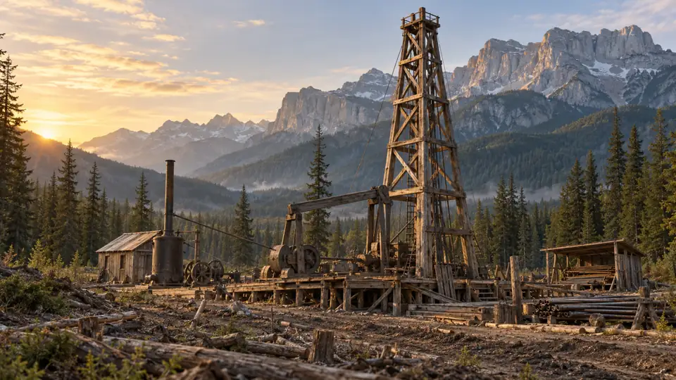
Imagine a cable-tool rig in a mountain clearing. A heavy steel bit rises, falls, and strikes rock. The engine keeps its rhythm. Then the tool string fails to come back.
That opening is an imagined reconstruction, not a recording of a particular shift. But the predicament is real. The historical record of the Akamina wells includes lost tools, abandoned holes, encouraging oil reports, and geologists who did not believe all the encouraging reports.
Today, a wooden derrick stands beside the visitor centre at Fernie, British Columbia. It points toward an oil story that unfolded farther south, in the Akamina and Sage Creek country of the Flathead region. Metal components recovered from those early operations became part of the Fernie landmark.
This is GeoNavigate Industry Chatter. I’m your AI narrator, Dorian. Our story is Fernie’s Forgotten Oil Frontier: The Derrick, the Seep and the Lost Tools.
The question behind it is familiar to anyone who has watched an oil show come across a wellsite desk. What have we actually found? A trace? A fracture carrying migrated oil? A reservoir that can sustain a rate? Or a promise that will become more expensive with every extra metre?
We have contemporary reports to work with, including a remarkable account published in British Columbia’s nineteen fifteen mining report. It describes oil and gas surging during casing work, a failed packer, casing pulled apart, and replacement equipment waiting for winter roads.
The story is dramatic enough without adding a fictional blowout or putting invented words into a driller’s mouth.
Chapter sources1
CHAPTER 02
First, let’s put the places in order. Fernie is where we encounter the reconstructed derrick. The early Akamina wells were in British Columbia, in the headwaters of the Kishinena drainage. Sage Creek was another exploration area, with its own seeps, wells, and structural setting.
Across the provincial divide, the Oil City story belongs to the Waterton area of Alberta. Parks Canada records that the Rocky Mountain Development Company began drilling there in nineteen oh one and struck oil in nineteen oh two. That brief success became the First Oil Well in Western Canada National Historic Site.
These stories are connected, but their well names and results cannot be shuffled together. A photograph of the Waterton rig is not automatically a photograph of Akamina Number One. A casing incident at Sage Creek is not evidence of a blowout beneath the Fernie visitor centre.
Even the name Akamina can mislead. A modern geological review points out that an early description used Akamina Brook for a stream now called Kishinena Creek. A historical place-name can move your imagined seep kilometres away from the actual observation.
And this was never an empty landscape waiting for oilmen to discover it. BC Parks describes the established routes used by Ktunaxa people through this mountain country. The drilling chapter came much later than that history.
For our purposes, keep three working labels in mind: Akamina for the lost-tool wells; Sage Creek for the more convincing seep trend and the nineteen fifteen operations; Waterton for the separate Alberta discovery.
CHAPTER 03
In the provincial report for nineteen oh three, the mineralogist described a visit to the Big Oil Spring on Sage Creek. The oil was difficult to locate until its smell gave it away. Dark green oil floated on pools near a water spring.
But the appearance was deceptive. The pools looked as though they contained much more oil than could actually be collected. The investigator described laying cloth over the surface, soaking up oil and water, wringing it into a container, and separating the two.
That is an extraordinary image: a future petroleum prospect being sampled with a cloth.
It also captures the central trap in the story. A thin film can spread over a large area of water. The visible footprint and the recoverable volume are different measurements. The sheen proves something is present. It does not measure the size of a reservoir.
The same report revisited an earlier seep description on another creek. This time the investigator could not reproduce the observation, even after camping at the described location. He considered the possibility that the seep was slight or only visible at particular water levels.
That is useful uncertainty. A missing show on one visit does not prove that an earlier observer lied. A reported show also does not become stronger simply because several later accounts repeat it.
The field question is what was observed, by whom, where, and under what conditions. Was it oil emerging from bedrock? Oil floating on water over covered ground? A sample from a well? A statement from a promoter?
Those distinctions mattered at Sage Creek. They still matter when a striking photograph is easier to circulate than the measurements behind it.
Chapter sources4
CHAPTER 04
The geology made the surface evidence especially puzzling. The exposed rocks were hard and compact. Early investigators saw shale, slate, quartzitic rocks and carbonate beds. They did not see an obvious, thick, porous oil sand beside every seep.
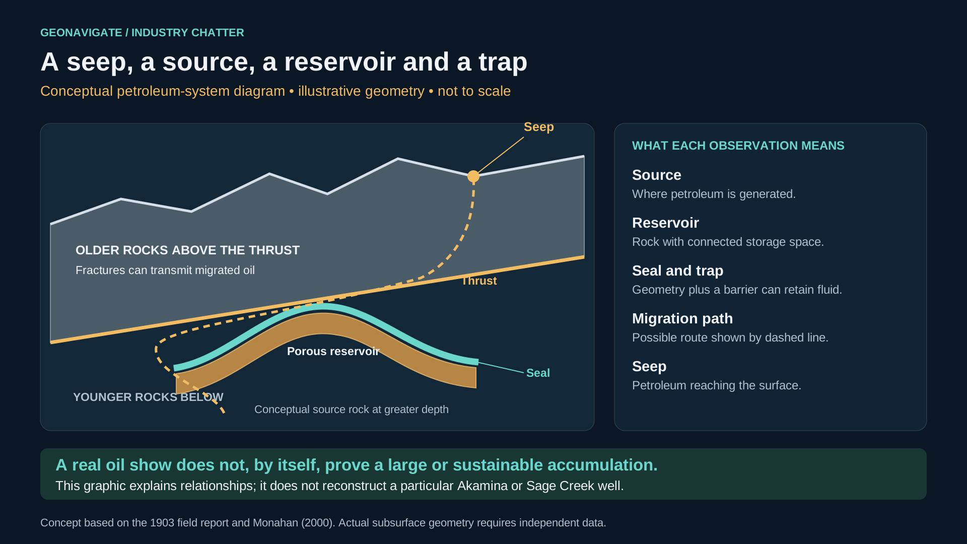
The nineteen oh three report explained an emerging answer: large thrust faults could place older rocks above much younger formations. Oil might have come from deeper rocks and migrated upward into fractures in the overlying mountain mass.
Think of a stack of pages pushed sideways until one thick packet rides over another. The page on top is no longer a reliable guide to the age of the page immediately beneath it. In a thrust belt, a drill can pass through old rock and eventually enter younger rock below a fault.
That is a conceptual explanation, not a surveyed cross-section through an Akamina well. The exact geometry must come from mapping, seismic interpretation and borehole evidence.
Modern work places the relevant ancient metasedimentary rocks in the Precambrian Purcell Supergroup. Some early reports called them Cambrian. When we read those reports, we have to preserve what the writers observed while updating the stratigraphic language.
The useful distinction is between where petroleum was generated and where it was found. Oil in a fracture does not require the surrounding rock to have generated it. Nor does a fracture containing oil necessarily connect to a large, replenishing volume.
A driller could encounter a real show, recover real oil, and still have no commercial well. The task was to discover whether the seep was the edge of a substantial petroleum accumulation or the leakage from a much less useful system.
CHAPTER 05
Now to the wells most closely associated with the Fernie derrick.
Local heritage accounts place Akamina Number One in nineteen oh seven and give a depth of about twelve hundred feet. The provincial geological compilation is less tidy. It lists the Royal Canadian Oil Company Number One, probably the same well as Akamina Number One, as nineteen oh eight or nineteen oh nine, with a total depth of three hundred and eighty-three metres.
Its entry records a reported oil-bearing interval at one hundred and eighty-two metres, a second reported oil zone near total depth, and tools lost in the hole. It also records that other geologists discounted the favourable reports. Number Two is listed at approximately one hundred and eighty metres, again with lost tools.
The dates remain uncertain. The historical compilation itself warns about possible duplicate well names and conflicting drilling years. We should not polish that uncertainty into a precise anniversary we cannot defend.
A cable-tool rig repeatedly lifts and drops a heavy cutting assembly. Broken rock and fluid are removed with a bailer. If equipment remains downhole, the drilling problem becomes a recovery problem: can you engage what is left, free it, and bring it back?
Every recovery attempt consumes time while the hole remains unfinished. Continuing depends on the obstruction, the condition of the hole, the equipment available, and the money behind the operation. Those are general engineering considerations; the surviving summaries do not tell us the exact failure mechanism in either Akamina hole.
We know the tools were lost. We do not know enough to invent a snapped cable, a particular fishing tool, or the conversation when the decision to abandon was made.
CHAPTER 06
In nineteen fourteen, geologist Ralph Arnold spent eight days investigating the district. His report, published by the province the following year, is valuable because it mixes encouragement with skepticism.
He described three approaches to the exploration country: from Belton in Montana, from Corbin to the north, and from the Oil City direction. He considered the Belton route the best available, but said it was suitable for wagons and pack animals rather than automobiles.
That logistical detail belongs beside the geology. A drilling prospect had to support equipment transport, fuel, supplies, repairs, and eventually a route out for any oil produced. A rich-looking show did not erase those costs.
Arnold was interested in the Sage Creek–Kishinena anticline, an arch in the strata along which seeps occurred. He thought there were plausible places to drill there. At Akamina, however, he described the wells associated with Gloyn in a syncline, a downward fold, and doubted reports of significant oil.
An anticline is not automatically a reservoir, and a syncline is not automatically barren. Arnold was judging the particular evidence and the petroleum model available to him. His report should be read as a contemporary interpretation, not a universal rule about where oil can occur.
He also described an oil-bearing Sage Creek well that had never been properly tested. He would not assign it a dependable capacity from appearance alone.
That restraint gives the episode its tension. The region contained enough evidence to keep attracting effort. It did not contain enough evidence to justify every claim being made about its future.
Chapter sources5
CHAPTER 07
The next document takes us much closer to the rig.
The provincial mining report for nineteen fifteen printed a letter from the manager of the Flathead Oil Syndicate’s operations. It is an operator’s account, reproduced by the government, rather than an independent production audit.
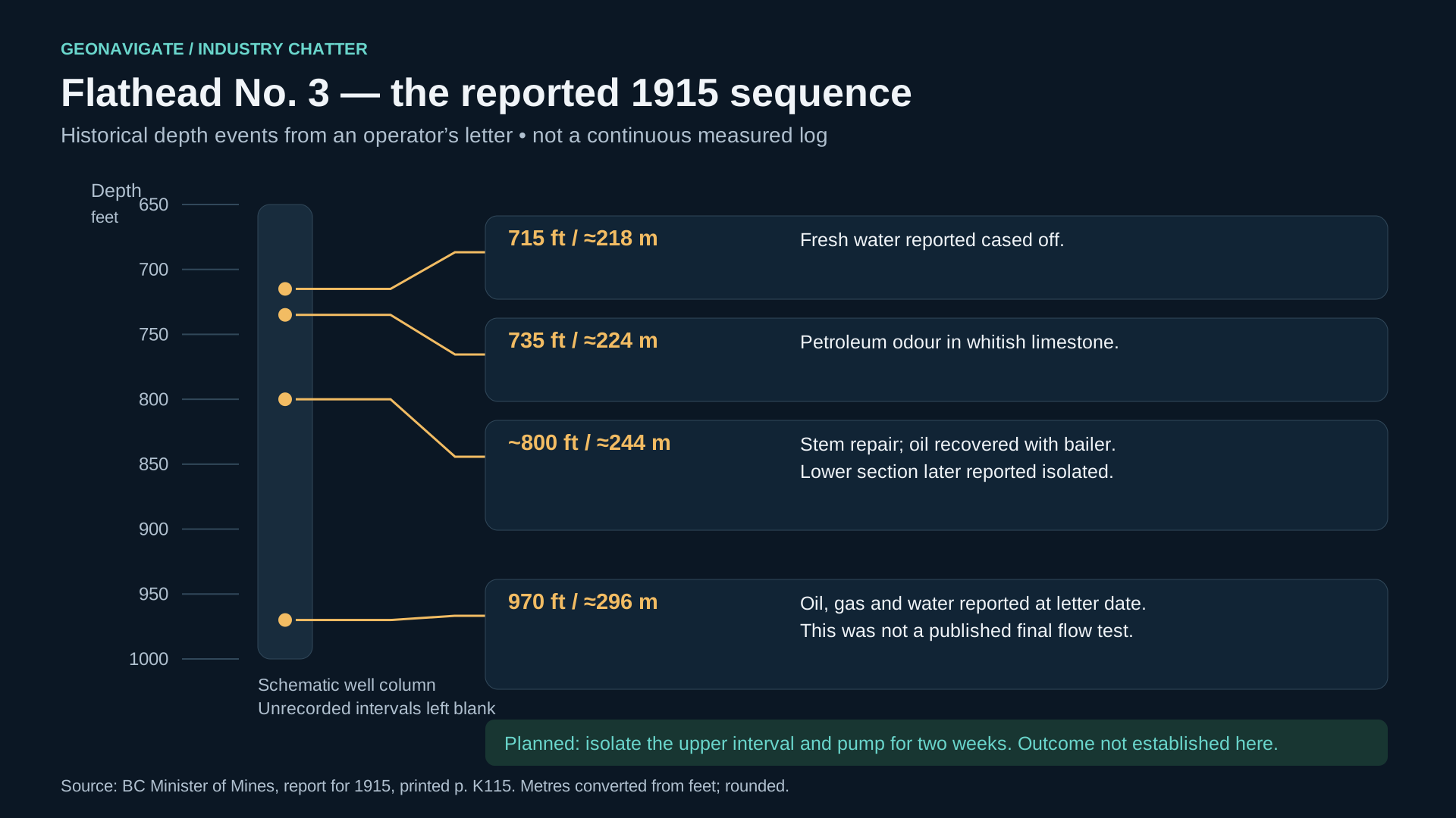
The manager reported that Number Three had reached nine hundred and seventy feet in badly broken bluish-grey limestone. He believed the drill was still in the overthrust formation, with more of that section below.
The sequence is specific. Fresh water had been cased off at seven hundred and fifteen feet. Twenty feet deeper, a whitish limestone carried a strong petroleum odour. The rock became darker and somewhat grainy, and oil was reported.
At around eight hundred feet, drilling stopped to weld the stem. When work resumed, the crew recovered oil with the bailer. According to the letter, a few runs filled a fifty-four-gallon drum about two-thirds full.
Then the well went deeper. By nine hundred and seventy feet, the reported influx included larger quantities of water, oil and gas.
The manager wanted to evaluate the upper oil-bearing interval. The account says material below the eight-hundred-foot level was cemented off, and a pump and storage tanks were ordered from Pittsburgh. The plan was to pump continuously for two weeks.
The drillers estimated two to ten barrels a day. The manager added four words that deserve to survive the century: “only test will tell.”
That test was a plan in the letter. The letter does not establish that the test achieved the estimated rate. It records what the operator wanted to determine.
For a modern listener, this is a recognisable evaluation problem: isolate an interval, separate the fluids, measure the rate over time, and find out whether the early excitement survives sustained observation.
Chapter sources6
CHAPTER 08
The same letter describes Number Two, also called the Davenport well. This is a Flathead operation at Sage Creek. It is not Akamina Number Two, even though the repeated numbering makes the stories easy to mix up.
The crew was trying to shut off artesian water. While seating casing, the manager reported two surges of oil, gas and water powerful enough to force the drillers away from their work. Some oil was caught after the flow subsided.
The report then turns from excitement to equipment trouble. The available casing was described as light. Another water flow appeared after a little more drilling. The crew pulled the casing and tried to reset it. A bottom-hole packer failed to do its job. During another attempt to pull the casing, it separated.
The well was shut down pending heavier casing and another packer.
We can describe that as a reported uncontrolled flow during casing work. We cannot assign a measured pressure, claim a fire, add fatalities, or turn it into a sustained gusher. None of those details is established by this account.
The practical difficulty is vivid enough. Water entry complicated the evaluation. The equipment needed to isolate it was failing. Replacement material was not sitting on a nearby service truck.
The manager expected the pump, tanks and casing to reach Belton, then be freighted into camp after the first snow. The operation had stocked provisions, coke and horse feed to get through the seasonal period of bad roads.
Here, snow was part of the supply plan. A mechanical failure could be tied to an entire transport season. The well’s next decision depended on rock, steel, weather, money, and the condition of a trail through the mountains.
Chapter sources6
CHAPTER 09
If these observations arrived at a geology desk today, the first job would be to preserve their sequence.
Where was the first water entry? What changed before the oil appeared? What happened after the stem repair? What entered the hole deeper down? What was isolated, and what remained open?
Those questions help separate a promising interval from everything else occurring in the wellbore. A bailer can recover oil without establishing a sustainable producing rate. A vigorous mixed-fluid flow can make a spectacular report while leaving the proportion of oil unresolved.
We would also want to know how the observations were measured. Was a volume gauged, estimated, or recalled later? Did the reported rate come from a timed test or from projecting a brief recovery? Were later writers describing the same event under a different well name?
The absence of a modern GR log is another limit. These early records do not give us a continuous electronic curve to recreate. We can draw a factual depth column from the reported events, with uncertain intervals left uncertain. Filling the gaps with invented log wiggles would make the picture more detailed and the evidence worse.
For the video accompanying this episode, an oil show, a casing depth and an abandoned hole should each look different. A conceptual thrust diagram should be labelled conceptual. An AI scene should be labelled a reconstruction. An original page should retain its date and attribution.
That approach allows the story to become visual without making the visuals pretend to be measurements. The record can be incomplete and still teach us something precise about how geological confidence is earned.
Chapter sources6
CHAPTER 10
The early campaigns did not establish the lasting commercial oilfield their backers hoped for. Later drilling revisited the region, and modern work investigated very different objectives beneath the Lewis thrust. The old seep hunt became part of a much longer effort to understand a difficult mountain petroleum system.
The equipment also acquired a second life. The Fernie Derrick Society describes the recovery of metal components in nineteen eighty-four. Local preservation accounts describe the later work that created and maintained the roadside landmark. That heritage history has its own chronology; recovery and reconstruction should not automatically be treated as the same event.
What remains compelling is the evidence left behind: the cloth used to collect an oil sheen; the ancient rock above younger strata; the optimistic show report beside a skeptical geological opinion; the lost tools; the parted casing; and the manager who insisted a proper test had to decide.
When you next pass the derrick at Fernie, imagine the distance between that landmark and the remote holes whose metal it preserves. Then imagine the larger distance between finding oil and proving an oilfield.
This has been GeoNavigate Industry Chatter. Our original reports, source notes and visual evidence are linked with the episode. The frontier left us more than an abandoned drilling story. It left a practical question for every generation of geologists: what does the evidence support, and what must the next observation settle?
THE VISUAL STORY
Reconstructions and conceptual diagrams are identified in their captions.
FOLLOW THE EVIDENCE
Local heritage account of the derrick, salvaged equipment and early Akamina exploration. Its first-well claim and drilling dates differ from government compilations; the episode identifies those differences rather than treating one account as settled.
F01Geological assessment published in 2000, used for the regional structure and exploration history. Its assessment reflects knowledge at that date; statements about resource potential or mineral rights are not presented as current determinations.
F02A compiled well table with conflicting dates and probable duplicate names. Although its title gives 1913–1952, some entries concern earlier drilling. The episode retains the uncertainty when comparing early Akamina accounts.
F03Report for 1903, published in 1904. It documents early observations and geological reasoning. Formation names reflect the terminology of the period and are distinguished from modern stratigraphic assignments.
F04Arnold’s assessment is dated 1914 and appeared in the report published in 1915. His conclusions are attributed to him and considered in the context of the geological interpretation and terminology available at the time.
F05The provincial report reproduces an operator’s letter describing shows, water entry and casing difficulties. This is operator testimony rather than an independently audited production test. The proposed test is not treated as a test known to have occurred.
F06Federal commemoration of the Cameron Creek well at Waterton, used to distinguish the Alberta story from the Akamina and Flathead wells in British Columbia. Historical flow-rate accounts are not presented as verified sustained production.
F07BC Parks provides geographical and historical context for Akamina-Kishinena and its established routes. The episode does not expand colonial hearsay into claims about Indigenous petroleum practices.
F08Mary Giuliano’s local history, dated June 1, 2021, describes the modern derrick project. The 1984 recovery of components and the 1986 construction work are retained as separate stages.
F09